May 15 ,2025.
Italy , Campi Flegrei :
Weekly Bulletin, from May 5, 2025 to May 13, 2025. (Issue date May 13, 2025)
SUMMARY OF ACTIVITY STATUS
Based on monitoring data, the following is highlighted:
1) SEISMOLOGY: During the week of May 5 to 11, 2025, 46 earthquakes with magnitude Md≥0.0 (Mdmax=2.3 ± 0.3) were located in the Campi Flegrei region. Since 12:06 local time on 13.05.2025, a seismic swarm has been in progress which, at the time of publication of this press release (16:00), has been characterized by 32 earthquakes of magnitude ≥0.0 and Mdmax equal to 4.4 ± 0.3, located in the coastal area of Pozzuoli.
During the swarm, other major events were of magnitude 3.5 ± 0.3 and 3.3 ± 0.3.
2) DEFORMATIONS: Since early April 2025, ground uplifts have continued to be recorded, with a monthly average value of approximately 15 ± 5 mm/month.
3) GEOCHEMISTRY: No significant variations were reported in the geochemical parameters monitored during the reference week compared to the already known trends of increased flow rates and warming of the hydrothermal system. The temperature sensor installed in a fumarolic outlet 5 meters from the main Pisciarelli fumarole last week showed an average value of approximately 97°C.
Source : INGV
Photo : Oibafa
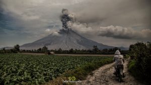
Indonesia , Marapi :
An eruption of Mount Marapi occurred on Wednesday, May 14, 2025, at 09:42 WIB with an observed ash column height of ± 1600 m above the peak (± 4491 m above sea level). The ash column was observed to be gray in color with a thick intensity, oriented toward the northeast. This eruption was recorded on a seismograph with a maximum amplitude of 30.4 mm and a duration of 62 seconds.
VOLCANO OBSERVATORY NOTICE FOR AVIATION – VONA
Issued : May 14 , 2025
Volcano : Marapi (261140)
Current Aviation Colour Code : ORANGE
Previous Aviation Colour Code : yellow
Source : Marapi Volcano Observatory
Notice Number : 2025MAR042
Volcano Location : S 0 deg 22 min 52 sec E 100 deg 28 min 23 sec
Area : West Sumatra, Indonesia
Summit Elevation : 9251 FT (2891 M)
Volcanic Activity Summary :
Eruption with volcanic ash cloud at 02h42 UTC (09h42 local).
Volcanic Cloud Height :
Best estimate of ash-cloud top is around 14371 FT (4491 M) above sea level or 5120 FT (1600 M) above summit. May be higher than what can be observed clearly. Source of height data: ground observer.
Other Volcanic Cloud Information :
Ash cloud moving to northeast. Volcanic ash is observed to be gray. The intensity of volcanic ash is observed to be thick.
Remarks :
Eruption recorded on seismogram with maximum amplitude 30.4 mm and maximum duration 62 second. Tremor recorded on seismogram with maximum amplitude 2 mm.
Source : Magma Indonésie .
Photo : Capture d’écran via Alex Terry / FB
Philippines , Kanlaon :
The Philippine Institute of Volcanology and Seismology (PHIVOLCS) reported continuing eruptive activity at Kanlaon during 6-13 May. Daily sulfur dioxide emissions ranged from 554 to 3,055 tonnes per day. Gas-and-steam plumes with occasional ash content rose as high as 1 km above the crater rim and drifted NW, W, SW, and SE. Periods of ash emissions were noted on 8 May (5 minutes) and 11 May (27 minutes). The seismic network recorded 5-10 daily volcanic earthquakes during 6-10 May and 63 volcanic earthquakes on 11 May. A total of 135 volcanic earthquakes were detected by the seismic network from 00h00 on 11 May to 12h00 on 12 May, including relatively strong volcanic-tectonic earthquakes, indicating rock fracturing due to rising magma or gases. A total of 72 volcanic earthquakes (M 0.3-3.1) recorded during 00h00-12h00 on 12 May were located 0-8 km beneath the N and NW flanks. PHIVOLCS issued an advisory at 13h30 on 12 May noting increased seismicity.
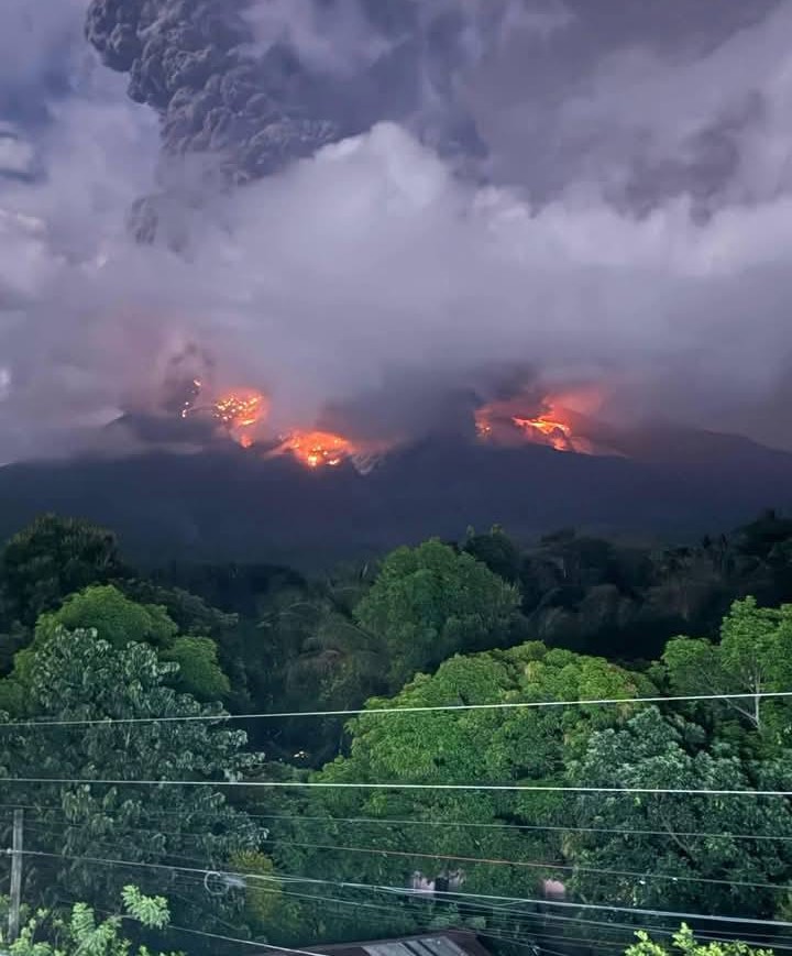
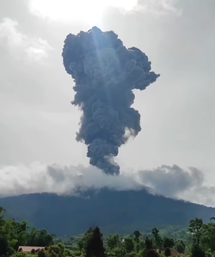
A moderately explosive eruption began at 02h55 on 13 May and lasted for five minutes based on seismic and infrasound data. Audible rumbling sounds were heard in barangays in Negros Oriental, including Pula and Canlaon City (10 km ESE), and in La Castellana (16 km SW) in Negros Occidental. A voluminous grayish ash plume rose about 4.5 km above the summit and drifted SW. Incandescent pyroclastic density currents descended the S flanks as far as 2 km based on visual and thermal camera monitoring. Large fragments were ejected from the crater a few hundred meters and set vegetation near the summit on fire. Minor ashfall was reported in the barangays of Yubo and Ara-al (La Carlota City, 14 km W), in Ilijan and Binubuhan (Bago City, 30 km NW), and in Biak-na-Bato, Sag-ang, and Mansalanao (La Castellana). According to news articles additional reports of ashfall came from San Carlos City (31 km ENE) and Bacolod (35 km NW), as well from the municipalities of Murcia (24 km NW), San Enrique (29 km W), Valladolid (34 km W), Pontevedra (29 km WSW), Hinigaran (35 km SW), and Binalbagan (38 km SW). A sulfur odor was also reported in several localities. According to the Tokyo VAAC the ash plume rose to 7.9 km (26,000 ft) a.s.l., or 5.5 km above the summit. Dozens of flights in and out of the affected areas were cancelled, and others delayed or rerouted, during 13-14 May. The Alert Level remained at 3 (on a scale of 0-5); the public was warned to stay 6 km away from the summit and pilots were warned not to fly close to the volcano.
Sources: Philippine Institute of Volcanology and Seismology (PHIVOLCS), Philippine News Agency (PNA), Air Asia, Cebu Pacific, Philippine Airlines, Tokyo Volcanic Ash Advisory Center (VAAC), GVP
Photo : Noelreels-on Rillon / FB .
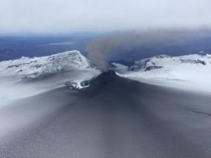
Costa Rica , Poas :
Latitude: 10.2
Longitude: -84.233
Height: 2,687 meters
Observed Activity:
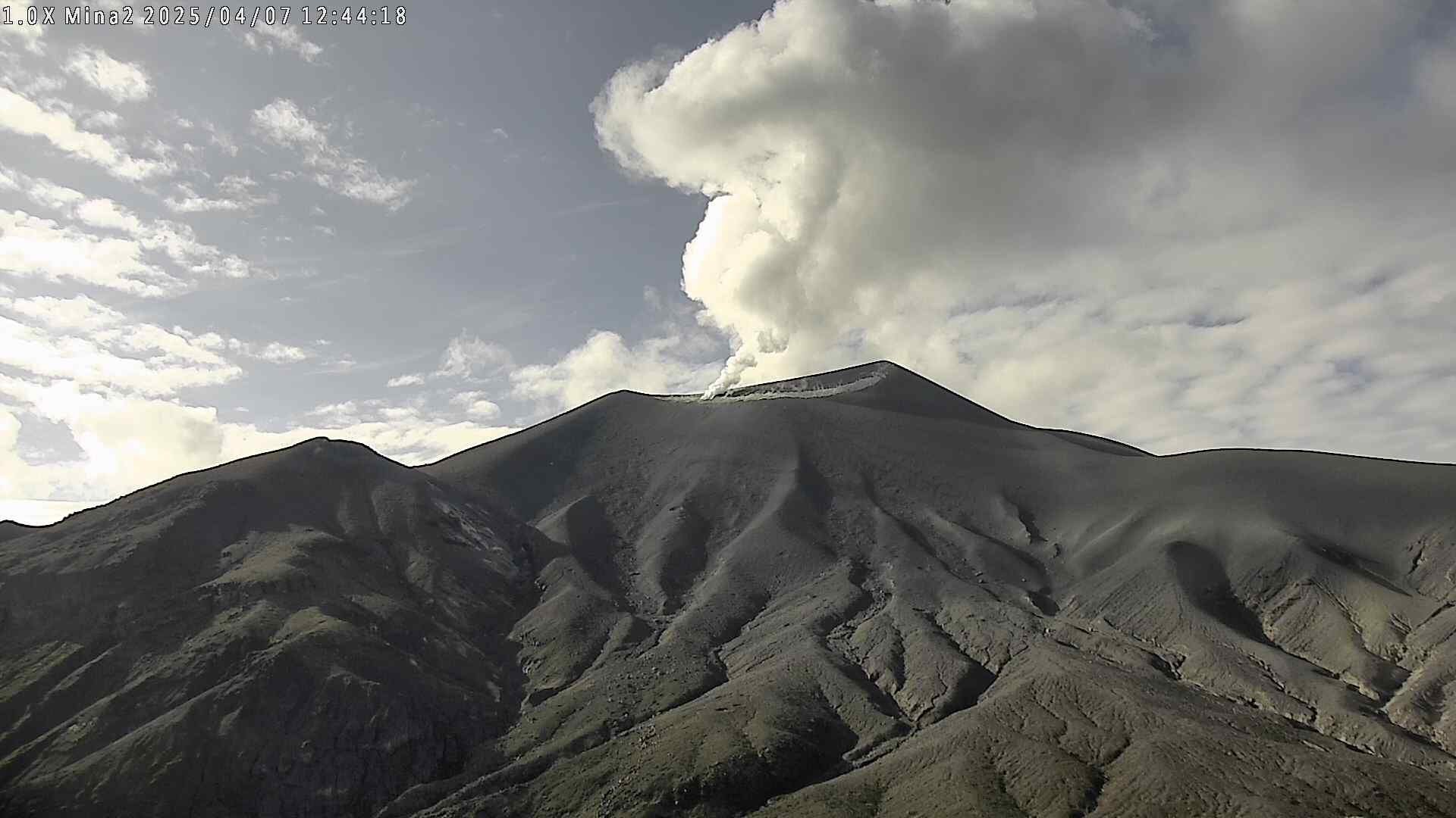
Seismographs and infrasound sensors do not record any energetic eruptions, although vigorous degassing of water vapor and SO2 has been recorded, primarily from Vent A, as well as frequent gurgling of fluids from Vent C. No ash emissions have been observed. Water from the torrential rains of the last two days is beginning to accumulate at the crater floor, increasing the flow of rivers flowing from the volcanic edifice, carrying significant amounts of ash emitted between March and April 2025. Infrared sensors on webcams detect thermal radiation at Vent A and reflected by water vapor and gas plumes during the night. Tremor has a frequency range of 1 to 7 Hz. On May 12, a maximum flux of 1,676 tons of SO2 per day was measured at ground level using the DOAS system. On the same day, the European SENTINEL satellite detected a mass of 305 tons of SO2.
Environmental conditions:
Cloudy conditions at the summit, with a prevailing southwesterly wind speed of 7 m/s (IMN).
Activity level: Caution (3)

The Observatorio Vulcanológico y Sismológico de Costa Rica-Universidad Nacional (OVSICORI-UNA) reported continuing gas-and-steam emissions that occasionally contained ash Poás during 6-13 May. Inflation continued to be detected. Sulfur dioxide emissions were as high as 1,703 tons per day (t/d) on 6 May. Some water had pooled at Boca C and was bubbling based on a drone observation that same day. Ash was very low or not detected in the steam-and-gas plumes during 5-7 May. Overnight during 7-8 May incandescence reflected in the emissions from sulfur combustion suggested temperatures less than 300 degrees Celsius. A significant eruptive event was detected in seismic and acoustic data at 14h04 on 8 May and lasted for two minutes. Weather conditions prevented direct visual observations of the event, though the seismic and acoustic data suggested an ash-and-gas plume rising into the 1-4 km high range; wind direction was to the SW. Bubbling at Boca C was again observed. Overnight during 8-9 May intense incandescence emanated from Boca A and a dense steam plume with minor ash content was observed. Continuous gas-and-steam plumes drifted SW during 12-13 May; the plumes were more intense from Boca A, where overnight incandescence was also observed. The volcano’s Alert Level remained at 3 (the second highest level on a four-level scale) and the Aviation Color Code remained at Orange (the second highest color on a four-color scale).
Sources : Ovsicori , GVP .
Photo : RSN / UCR
Colombia , Puracé – Los Coconucos volcanic chain.:
Popayán, May 13, 2025, 2:00 p.m.
According to monitoring of the activity of the Puracé volcano – Los Coconucos volcanic chain, the Colombian Geological Survey (SGC), an entity affiliated with the Ministry of Mines and Energy, reports that:
During the week of May 6-12, seismic activity showed a slight decrease compared to the previous week, both in the number of events recorded daily and in the energy levels released.
Earthquakes associated with rock fracturing occurred mainly between the Puracé and Piocollo volcanoes, at depths less than 5 km, and reached a maximum magnitude of 1.9. Fluid dynamic events were concentrated mainly beneath the crater of the Puracé volcano, at depths less than 3 km, and were characterized by their low energy input. Moderate values of sulfur dioxide (SO2) and carbon dioxide (CO2) emissions were recorded by satellite and field instruments. In addition, the slow deformation process continued between the volcanic edifices of Puracé, Piocollo and Curiquinga.
In images captured by visible and infrared webcams, degassing processes continued to be observed in the lateral fumarole and within the crater of Puracé Volcano, characterized by gas columns reaching heights of up to 1.5 km above the summit of the volcanic chain.
In conclusion, continuous degassing from the lateral fumarole and crater of Puracé Volcano continued throughout the week, accompanied by moderate SO₂ and CO₂ emissions, with localized seismic activity beneath the structures of Puracé and Piocollo Volcanoes, as well as slow ground deformation, indicating the persistence of an active volcanic system.
Under Yellow alert status, phenomena such as sporadic ash emissions (minor eruptions of limited magnitude and impact, whose dispersion depends on wind direction), the presence of incandescence, small explosions in the crater, low-energy thermal anomalies, noise, felt earthquakes, odors, precipitation of elemental sulfur near the crater and in hot springs and fumaroles, as well as degassing in areas outside the crater, may occur. Fissure formation and the occurrence of minor lahars, among other things, are also observed.
Based on the above, the SGC recommends closely monitoring the evolution of volcanic activity through weekly bulletins and other information published on official channels, as well as heeding the instructions of local and departmental authorities and the National Disaster Risk Management Unit (UNGRD). The alert status for volcanic activity remains at yellow alert: active volcano with changes in the behavior of the base level of monitored parameters and other manifestations
Source et photo : SGC .