June 11 , 2022.
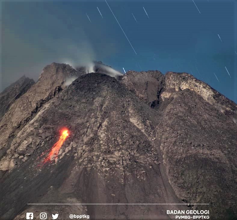
Indonesia , Merapi :
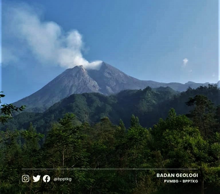
Mount Merapi activity report from June 3 to 9, 2022
– This week, 75 lava avalanches were observed in a southwesterly direction, descending the Bebeng River with a maximum sliding distance of 2,000 m.
– For the southwest dome, there is no change in the height of the dome. For the central dome, no significant morphological change was observed. According to photo analysis, the volume of the Southwest lava dome is 1,551,000 m3 and that of the central dome is 2,582,000 m3.
Seismicity:
This week, the seismicity of Mount Merapi recorded:
2 low frequency earthquakes (LF)
84 shallow volcanic earthquakes (VTB),
283 multi-phase earthquakes (MP),
666 avalanche earthquakes (RF),
23 emission earthquakes (DG),
9 tectonic earthquakes (TT).
– The intensity of seismicity this week is still quite high.
Mount Merapi’s deformation, which was monitored using EDM this week, showed a distance shortening rate of 1.5 cm/day.
A precipitation intensity of 21 mm/hour is recorded for 35 minutes at Pos Ngepos on June 8, 2022. No reports of lahars or additional flow in the rivers that originate on Mount Merapi.
Conclusion:
1. Merapi volcanic activity is still quite high in the form of effusive eruption activity. The state of the activity is defined at the « SIAGA » level.
2. The current potential danger is lava avalanches and hot clouds in the South-South-West sector covering the Boyong River for a maximum of 5 km, the Bedog River, Krasak, Bebeng for a maximum of 7 km. The Southeast sector covers the Woro River for a maximum of 3 km and the Gendol River for a maximum of 5 km. Meanwhile, the ejection of volcanic material in the event of an explosive eruption can reach a radius of 3 km around the summit.
The public should not carry out any activity in potentially dangerous areas, anticipate disturbances due to volcanic ash from the Merapi eruption and be aware of the dangers of lahars, especially when it rains around Merapi.
Source et photos: BPPTKG
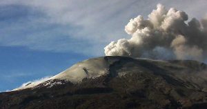
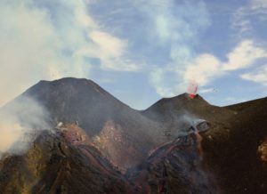
Chile , Lascar :
Seismology
The seismological activity of the period was characterized by the recording of:
5 VT-type seismic events, associated with rock fracturing (Volcano-Tectonics). The most energetic earthquake presented a value of Local Magnitude (ML) equal to 2.5, located 1.2 km south-south-east of the volcanic edifice, at a depth of 4.5 km from the crater.
6 LP-type seismic events, associated with fluid dynamics within the volcanic system (Long Period type). The size of the largest earthquake estimated from the reduced displacement parameter (RD) was equal to 7 cm2. No event presented the minimum energy to locate it
Fluid Geochemistry
Data on sulfur dioxide (SO2) emissions obtained by means of Differential Absorption Optical Spectroscopy (DOAS) equipment, corresponding to the Emu station, located 6 km to the East-South-East (ESE ) from the active crater, showed an average value of 780 ± 99 t / d, with a maximum daily value of 1207 t / d on May 27, observing similar rates of SO2 as during the previous period. The values are in low ranges for the Láscar volcano.
No anomalies were reported in the emissions of sulfur dioxide (SO2) into the atmosphere in the area near the volcanic complex, according to data published by the Tropospheric Monitoring Instrument.
Satellite thermal anomalies
20 thermal alerts were recorded in the area associated with the volcanic edifice during the period, with a maximum Volcanic Radiative Power (VRP) of 4 MW on May 20 and 27, a value considered low according to the data processed by the ‘Middle Infrared Observation of Volcanic Activity (MIROVA (http://www.mirovaweb.it/). Meanwhile, according to the analytical processing of satellite images (Sentinel 2-L2A in combination of false color bands), anomalies of luminance were observed on days 3, 8, 13, 18, 23, 28 and 31, with an estimated maximum luminance area of 7200 m2 on May 31.
Geodesy
From the data provided by 2 GNSS stations installed on the volcanic edifice, during the month evaluated, a period of stability was recorded compared to the previous month, presenting slight variations in position, reaching a maximum rate not exceeding 0 .1 cm/month on the tracking line. Therefore, no sign of volcano deformation associated with volcanic activity was observed.
Surveillance cameras
Thanks to the analysis of the images from the fixed cameras, periods of degassing were observed, with columns composed mainly of gas and water vapour. The maximum height of the columns reached 360 m on May 8, 2022.
Regarding incandescence, there was an increase in episodes of incandescence during the month (02, 03, 08, 09, 10, 20, 21, 22, 27, 29 and 31), highlighting the episode occurred on the 20th with an incandescence that lasted a few hours (01:40 – 07:00 UTC).
GREEN TECHNICAL ALERT: Active volcano with stable behavior – There is no immediate risk
Source : Sernageomin.
Photo : 80 jours voyages / Sylvain Chermette.
Alaska , Pavlof :
55°25’2″ N 161°53’37 » W,
Summit Elevation 8261 ft (2518 m)
Current Volcano Alert Level: WATCH
Current Aviation Color Code: ORANGE
Pavlof Volcano continues to erupt from the active vent on the east flank just below the volcano’s summit. Seismic tremor and elevated surface temperatures were observed throughout the week. These are associated with low-level eruption and formation of short lava flows extending up to 500 m (1640 ft) long on the upper flank. No explosions or ash emissions were observed in satellite or webcam images this week.

Periods of lava spatter and fountaining from the vent on the volcano’s upper east flank have been occurring since mid-November 2021. This activity has built a small cone and sent flows down the flank that melt the snow and ice and produce variable amounts of meltwater. The meltwater typically incorporates loose debris on the flank of the volcano and forms thin (less than 2 m thick) lahars. The lahar deposits extend down the east-southeast flank for several kilometers, not quite to the base of the volcano.
Previous eruptions of Pavlof indicate that the level of unrest can change quickly and the progression to more significant eruptive activity can occur with little or no warning.
Pavlof is monitored by local seismic and infrasound sensors, satellite data, web cameras, and remote infrasound and lightning networks.
Source : AVO.
Photo : Loewen, Matt / Alaska Volcano Observatory / U.S. Geological Survey.
La Martinique , Montagne Pelée :
Weekly report on the activity of Mount Pelee for the period from June 03, 2022 to June 10, 2022.
Between May 27, 2022 at 4 p.m. (UTC) and June 3, 2022 at 4 p.m. (UTC), the OVSM recorded at least 4 volcano-tectonic earthquakes including:
-2 Earthquakes of magnitude less than or equal to 0.1. These earthquakes were located inside the volcanic edifice between 0.5 and .9 km deep below the surface. This superficial volcano-tectonic seismicity is associated with the formation of micro-fractures in the volcanic edifice.
-2 earthquakes with a magnitude of 0.2 and 1.9, located respectively at 8.6 and 13.5 km deep below the surface, about 1 km away to the southwest and northwest of the volcano. These earthquakes could be associated with fracturing inside the Caribbean plate located under the volcanic edifice.
None of these earthquakes were felt by the population.

The zone of degassing at sea at shallow depth between St Pierre and le Prêcheur is still observed. The IGP took fluid samples in order to understand the origin of this degassing and to assess its possible relationship with the Mount Pelée hydrothermal system.
An extension of two areas of degraded vegetation located between Morne Plumé and the Rivière Chaude was observed during a helicopter flight carried out on February 9, with the support of the Dragon 972, and confirmed by analysis of satellite images.
The alert level remains YELLOW: vigilance.
Source : Direction de l’OVSM IPGP.
Photo : cntraveler.com
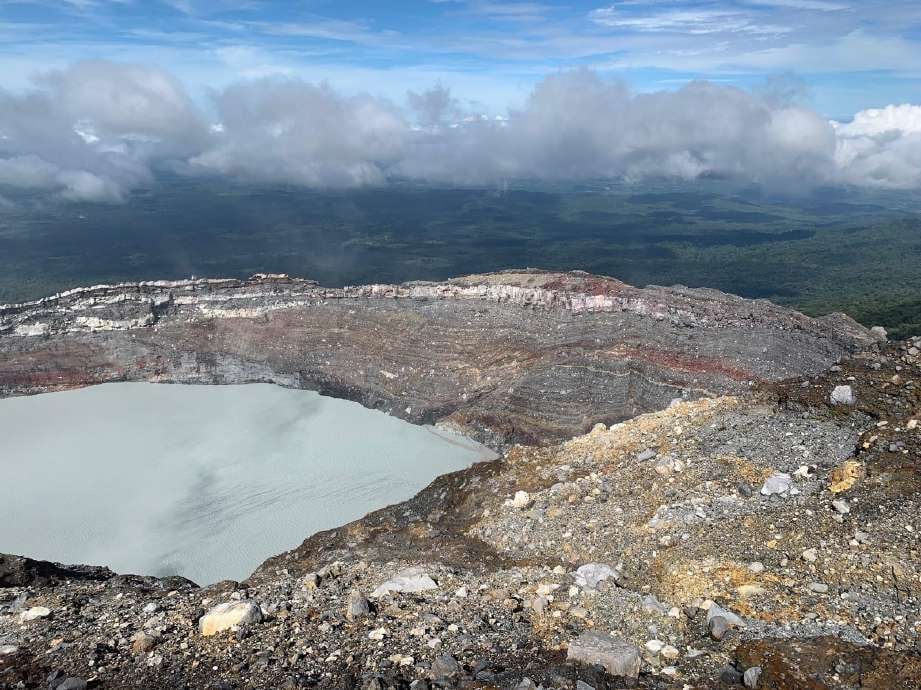
Costa Rica , Rincon de la Vieja :
On 06/10/2022 at 4:52 p.m. local time, an eruption was recorded at the level of the Rincón de la Vieja volcano, the height reached by the column is unknown due to the visibility conditions of the site.
Duration of the activity: 1 minute.
Ash fall: No ash fall reported
Sulfur Odor: No sulfur odor reported
Comments: A small eruption was detected in seismic and infrasound recordings.
Seismic activity is similar, compared to yesterday.
At the time of this report, the winds are blowing westerly.
Yesterday a small hydrothermal eruption was recorded at 12:48 p.m. The column of gas and water vapor reached a height of 200 meters. Seismicity is maintained with frequent low-frequency volcanic earthquakes, « Tornillos » type earthquakes and low-frequency, short-duration tremors. No significant deformation of the volcanic edifice is recorded.
Source : Ovsicori.
Photo : Juan Carlos López del ICE.