September 17 , 2021.
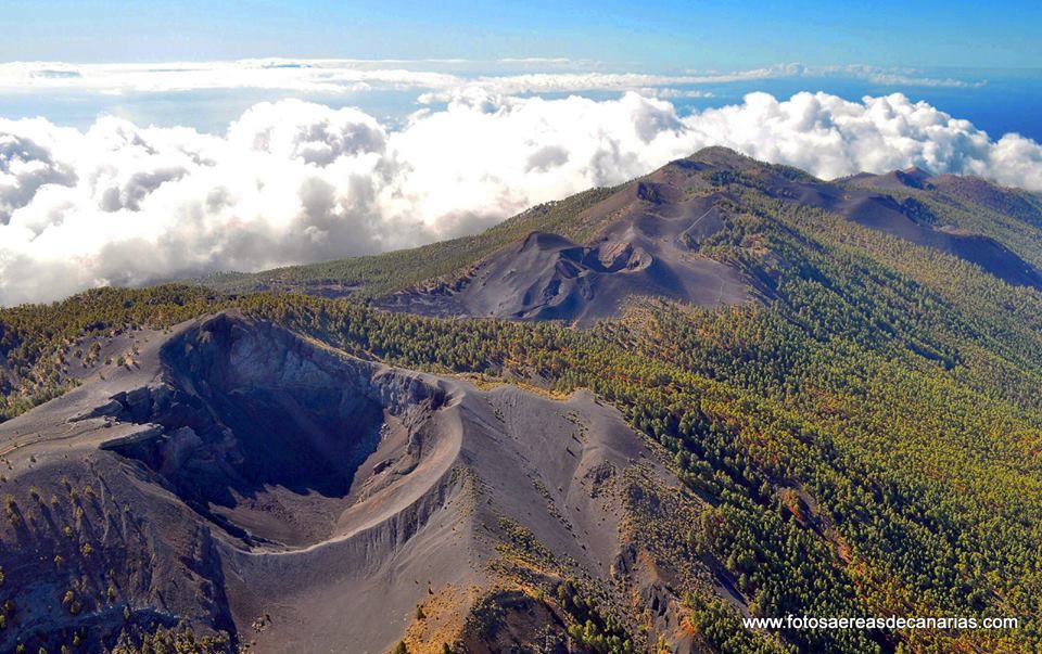
Spain / La Palma , Cumbre Vieja :
Update of information on the seismic-volcanic activity of the Cumbre Vieja volcano (La Palma, Canary Islands): 11 million cubic meters of magma have already been injected.
The geodesic network of the Canary Islands, operated by the Volcanic Institute of the Canary Islands (INVOLCAN), has recorded, in recent days, a significant deformation of the terrain of volcanic origin.
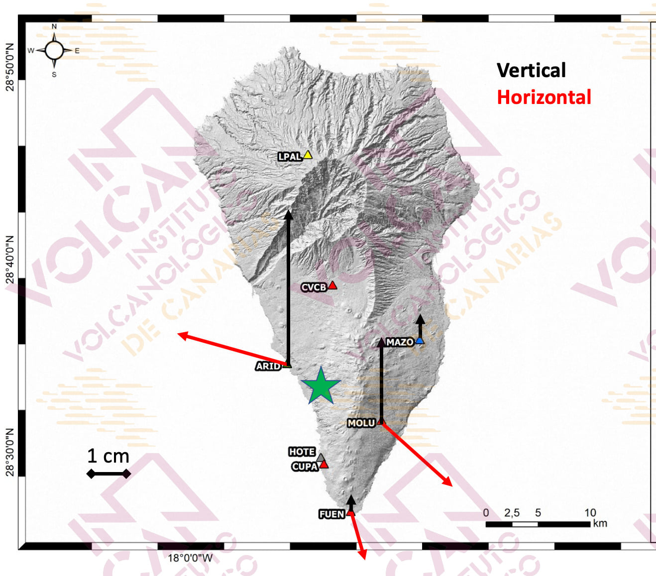
The figure shows the horizontal (red arrows) and vertical (black arrows) movement in some of the GNSS stations that are part of the network. This deformation pattern can be interpreted as the effect of the pressurization of a small magmatic reservoir, with a volume of about 11 million cubic meters, located inside the Cumbre Vieja volcano, in the same area where the Most of the recent swarm’s earthquakes have occurred, and at a depth of about 6-7 km.
This observation confirms that the source of this swarm, which began last Saturday, September 11, 2021, has a magmatic origin and is linked to the intrusion of a small volume of magma inside the Cumbre Vieja volcano.
Updated information on volcanic activity in the south of the island of La Palma. September 16, 2021 13:00 UTC.
Seismic activity continues to migrate slightly to the northwest, at depths of around 8 km, with 50 shallow earthquakes between 1 and 5 km also recorded. The maximum cumulative deformation reaches about 10 cm.
Seismic activity began at 3:18 a.m. (UTC) on September 11. As of 9:30 am (UTC) today, 4,530 earthquakes have been detected in the southern area of the island of La Palma, of which a total of 1,023 have been located. The activity continues to migrate slightly towards the North-West. As of 00:11 (UTC) on September 15, 50 earthquakes have been located at depths between 1 and 5 km. The energy accumulated so far is 2.8 × 10¹¹ Joules.
The maximum cumulative vertical deformation is of the order of 10 cm in the zone close to seismicity and its distribution is still compatible with a center of pressure in this zone. These movements were observed both with the island’s GNSS network and with InSAR data (Sentinel-1).
The earthquakes of this latter swarm are more shallow compared to previous seismic swarms, where the depth varied between 20 and 30 km. The current seismic swarm undoubtedly represents a significant change in the activity of the Cumbre Vieja volcano and is linked to a process of magmatic intrusion under the island of La Palma. The sea centers are found under the Cumbre Vieja volcano, usually at depths between 9 and 12 km, although in recent days some earthquakes have been located at a depth of less than 5 km. The maximum magnitude observed so far was 3.4 on the Richter scale.
The IGN has stepped up the continuous monitoring of the activity.
Source : Involcan , IGN.
Photo : fotosaereasdecanarias.
Japan , Suwanosejima :
The volcano on a southwestern Japan island erupted early Friday, sending large rocks almost 1 kilometer from the crater and prompting the weather agency to raise its alert by one level to restrict entry into the area surrounding the mountain.
The eruption occurred at the crater of Mt. Otake on Suwanose Island of Kagoshima Prefecture at around 2:12 a.m. There were no immediate reports of injuries, according to local authorities.
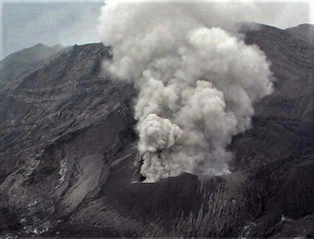
Mt. Otake on Suwanose Island in Kagoshima Prefecture erupted around 12:04 a.m. on June 23, 2021. (Photo courtesy of Kagoshima Meteorological Office) (Kyodo)
The Japan Meteorological Agency raised its alert level to 3 on a scale of 5, meaning that people should not approach the mountain. The agency also warned of the potential for big rocks to be hurled into the air within about a 2-km radius of the crater of the 799-meter mountain in Toshima village.
According to the agency, multiple explosions occurred at the crater on Thursday. Following the eruption early Friday, the government also set up a liaison office at the prime minister’s office to gather information.
Suwanose, a volcanic island with a population of less than 100, is located to the south of Japan’s southernmost main island of Kyushu.
Source : kyodonews.
Photo: Helicopter shot from Kagoshima Prefecture by JMA.
Philippines , Taal :
TAAL VOLCANO BULLETIN 17 September 2021 8:00 AM
In the past 24-hour period, the Taal Volcano Network recorded eighteen (18) volcanic earthquakes, including eight (8) volcanic tremor events having durations of one (1) to three (3) minutes, ten (10) low-frequency volcanic earthquakes, and low-level background tremor that has persisted since 7 July 2021 .
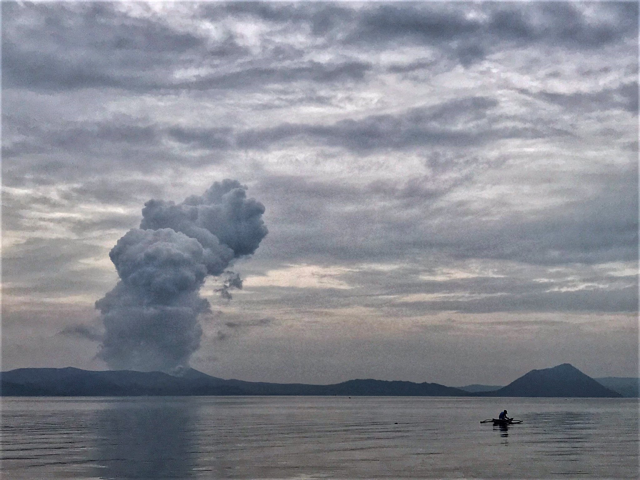
Activity at the Main Crater was dominated by upwelling of hot volcanic fluids in its lake which generated plumes 1,500 meters tall that drifted west-northwest and southwest. Sulfur dioxide (SO2) emission averaged 7, 124 tonnes/day on 16 September 2021. Based on ground deformation parameters from electronic tilt, continuous GPS and InSAR monitoring, Taal Volcano Island has begun deflating in April 2021 while the Taal region continues to undergo very slow extension since 2020.
Source : Phivolcs .
Photo : Rizal M .
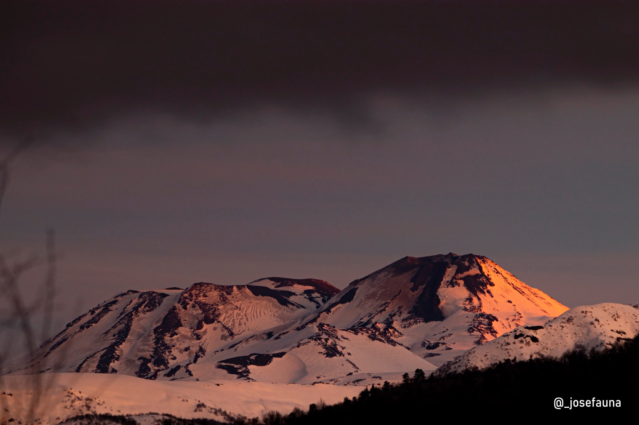
Chile , Nevados de Chillan :
Special Report on Volcanic Activity (REAV), Region of Ñuble, Nevados de Chillán Volcanic Complex. September 16, 2021, 7:45 p.m. Local time (Continental Chile)
The National Service of Geology and Mining of Chile (Sernageomin) publishes the following information obtained through the monitoring equipment of the National Volcanic Monitoring Network (RNVV), processed and analyzed in the Volcanic Observatory of the Southern Andes (Ovdas ):
The eruptive cycle of the Nevados de Chillán volcanic complex (CVNCh) continues to evolve regularly and with some important changes, fundamentally with regard to the deformation and morphology of the effusive body located in the active crater.
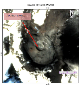
From the photo-interpretation of a very high-resolution SkySat image dated September 15, 2021, the growth of an effusive body attributable to a dome-shaped morphology inside the Nicanor crater is identified. Ellipsoidal in shape, it has a major axis of 40 m and a minor axis of 27 m (Figure 1). It has an elongated shape in a North-West-South-East direction and according to the analysis of Sentinel 2 L2A satellite images of the same date, it is confirmed that it has an abnormal thermal radiation. The evolution of this new morphology in the coming days will allow more complete interpretations as to its dynamics.
In terms of surface activity, the appearance of this new morphology was preceded by a considerable decrease in the extrusion rate of the L5 and L6 castings, the disappearance of the thermal anomalies which explain a decrease in the temperature of these castings of lava, as well as the disappearance of episodes of nocturnal incandescence during most of the first half of September. Regarding the latter, they return with low intensity on the 14th of this month. Explosive activity, on the other hand, is maintained with moderate column heights (<1000 m) and generally low pyroclastic content, with isolated episodes of higher charge.
Regarding the seismicity of September, particularly since the 11th and after a clear decrease in activity observed during the month of August, the Nevados de Chillán volcanic complex exhibited a subtle increase in seismic activity (LP type events and TR) of low energy (<220 cm2) and low rate of occurrence of the number of earthquakes.
Likewise, the recording of an LP-type seismic signal emerges on September 7 associated with an explosion and followed by a “harmonic tremor”; From this day, the amount of signals with this harmonic characteristic has been recorded more frequently until today. Regarding VT-type seismicity, its occurrence is still low, but reaching local magnitudes of up to M 2.4 on September 9. In general, the RSAM of the continuous seismic signal, calculated every 6 hours, shows a gradual increase since yesterday, September 14, coinciding with a greater recording of volcanic seismic signals, in particular of the LP and tremor type.
4 thermal alerts were recorded in the area associated with the volcanic complex during the last 2 days, with a maximum Volcanic Radiative Power (VRP) of 2 MW on September 16, associated with the crater area, a value considered low according to the data processed by mid-infrared observation of volcanic activity (MIROVA (http://www.mirovaweb.it/) Concerning hazard zoning, this is maintained with a radius of 2 km around the active crater.
Source : Sernageomin .
Photos : Skysat , Josefauna .
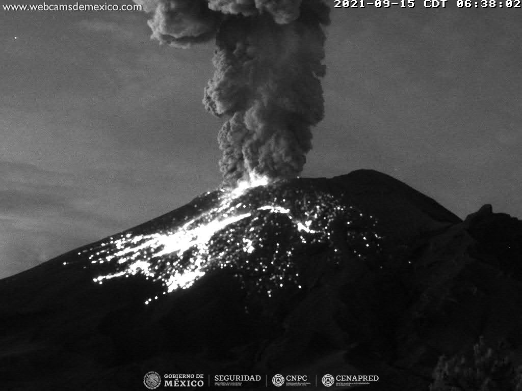
Mexico , Popocatepetl :
Popocatepetl volcano monitoring report, September 16, 2021.
The Popocatépetl volcanic traffic light is in PHASE 2 YELLOW.
During the last 24 hours, according to the monitoring systems of the Popocatépetl volcano, 103 exhalations have been identified, some accompanied by water vapor, volcanic gases and ash. The emissions were mainly dispersed to the northwest (NW). Yesterday at 14:41 a minor explosion was recorded, which produced a column at 1800 m altitude, the emission moved to the North-West (NW). There was also 83 minutes of low to medium amplitude tremor and a volcano-tectonic (VT) earthquake with a calculated magnitude of 1.9 yesterday at 12:10 p.m. (local time).
Based on information from the National Center for Communication and Civil Protection Operations (CENACOM), light ash falls were reported in the municipalities of Valle de Chalco, Chiautla, Ixtapaluca, Nezahualcóyotl, La Paz, Ecatepec, Ayapango, Temamatla, Tenango del Aire, Tlalmanalco, Amecameca, Tepetlixpa, Tlalnepantla and Acolman in the State of Mexico.
At the time of this report, a continuous emission of water vapor, gas is observed. The cloud is moving northwest (NW).
CENAPRED recommends NOT TO APPROACH the volcano and especially the crater, because of the danger of falling ballistic fragments and, in the event of heavy rains, to stay away from the bottom of the ravines because of the danger of mudslides and debris.
Source et photo : Cenapred .