July 01 , 2021.
Italy / Sicily , Etna :
Weekly Bulletin, from June 21, 2021 to June 27, 2021 (issue date June 29, 2021)
SUMMARY STATEMENT OF ACTIVITY
In view of the monitoring data, it is highlighted:
1) VOLCANOLOGICAL OBSERVATIONS: Strombolian activity, episodes of lava fountains, and formation of eruptive columns at the Southeast Crater; occasional ash emission at the Northeast Crater; pulsed degassing with low ash emissions at the Bocca Nuova Crater; ordinary degassing at the Voragine Crater.
2) SEISMOLOGY: Seismic activity of weak fracturing. Large and sudden variations in the amplitude of the tremor are correlated with paroxysmal episodes.
3) INFRASOUND: high infrasound activity in conjunction with the lava fountain episodes at the Southeast Crater, low in the remaining period.
4) DEFORMATIONS: During the last week, the inclinometric network recorded significant changes in correspondence with the events of the lava fountains.
Analysis of the GNSS data acquired at high frequency did not show any significant changes.
5) GEOCHEMISTRY: The flow of SO2 at an average level, with high values during the eruptive phases.
The CO2 flux from the soil showed an increase, the values went from medium to high.
The partial pressure of dissolved CO2 does not show significant changes.
There are no updates for the C / S report.
The isotopic ratio of helium remains stable on average values (last update of 06/21/2021).
6) SATELLITE OBSERVATIONS: The thermal activity in the summit area was high to very high in correspondence with the lava fountains.
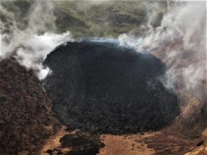
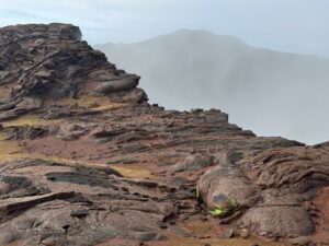
VOLCANOLOGICAL OBSERVATIONS
During the week, the monitoring of the volcanic activity of Etna was carried out by analyzing the images of the network of surveillance cameras of the section INGV Catania, Osservatorio Etneo (INGV-OE), and by the staff of the ‘INGV in the field.
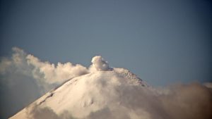
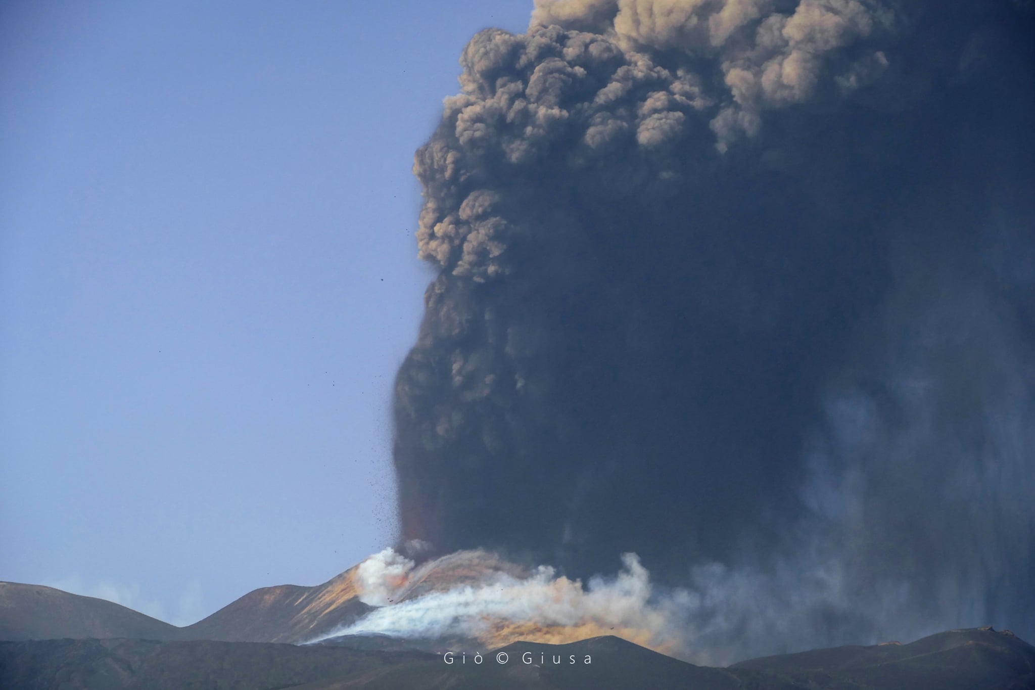
During the week, there were 9 episodes of lava fountains in the Southeast Crater (SEC), with the formation of eruptive columns, which reached heights ranging from a minimum of 5 km to a maximum of 10 km above sea level. All lava fountains were mainly accompanied by lava overflows to the southwest; in certain intervals between eruptive episodes, an effusive vent remained active on the south-eastern flank of the South-eastern Crater. The fallout from products on the ground mainly affected the east, south-east and north-east sectors of the volcano.
The flows emitted from June 22 to 25 and June 26 and 27 were mapped thanks to the analysis of the Sentinel 2 satellite images of June 23, 26 and 28 and by applying an algorithm, to reconstruct the images taken by the thermal camera of the Monte Cagliato on June 23, 24, 25 and 26. It was not possible to distinguish the flow of June 26 towards the southwest from that of June 27.
The eruptive episodes occurred on June 21 (shortly after midnight local time), June 22 (at dawn), June 23 (at dawn and dusk), June 24 (late morning) , June 25 (before sunrise and sunset), June 26 (afternoon) and June 27 (late morning). The explosive activity was concentrated mainly in the western part of the Southeast Crater, in an area also known as the « saddle mouth », where three or four mouths were often active, while the « eastern mouths » area was not. produced only isolated and weak explosions on certain occasions. However, we note the opening of effusive vents on the southeast flank of the cone of the Southeast Crater, on June 23, which represents a partial reactivation of the eastern part of the eruptive system of this crater.
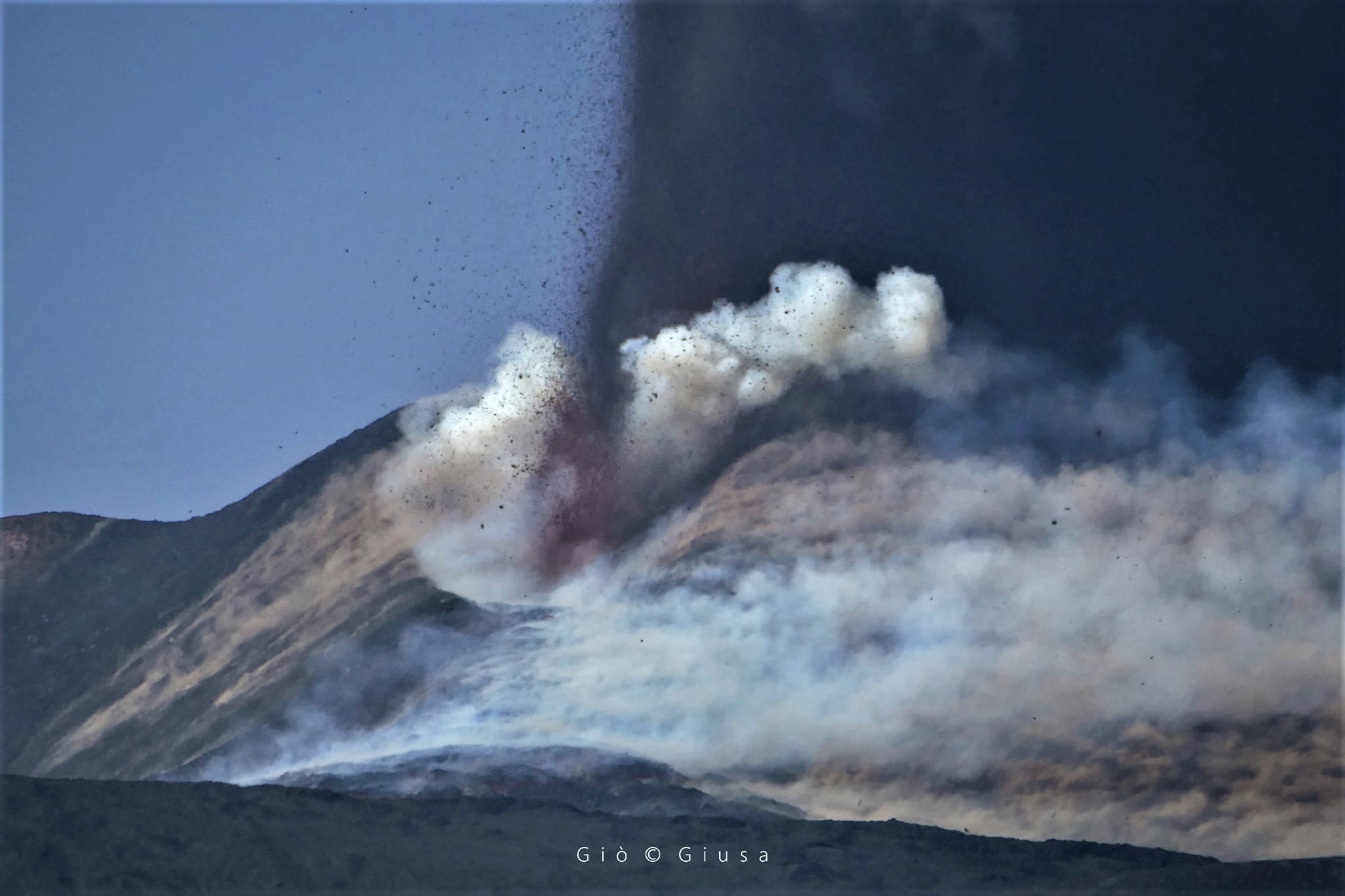
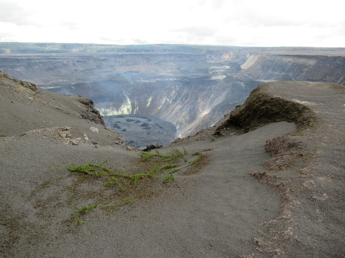
In this week with very frequent paroxysmal episodes, the rapid growth of the cone of the Southeast Crater continued, which strongly altered not only the morphology of the same cone, but the overall silhouette of Etna. Although of the « old » cone of the Southeast Crater (1971-2007) only a sort of inconspicuous bump remains visible, its shape is still well preserved when viewed from the eastern edge of the Bocca Nuova crater. . In the center of the depression of its crater is a fumarole which emits a bluish gas.
Volcanic tremor: The trend of the average amplitude of the volcanic tremor, during the week in question, was conditioned by the occurrence of 8 intense phases of volcanic activity, which evolved into a lava fountain of the South Crater. Is . During these paroxysmal episodes, the mean amplitude of the tremors reached the high range, while in the periods between these episodes, the amplitude of the tremors returned to low and medium-low values. In particular, throughout the week, the source of the tremor was mainly located near the Southeast Crater at a depth between 1,500 and 3,000 m above sea level.
Source : INGV.
Photos : Gio Giusa .
Italy , Stromboli :
Weekly Bulletin, from June 21, 2021 to June 27, 2021 (issue date June 29, 2021).
SUMMARY STATEMENT OF ACTIVITY
In view of the monitoring data, it is highlighted:
1) VOLCANOLOGICAL OBSERVATIONS: Ordinary explosive activity associated with discontinuous and variable splashing, modest short-lived lava overflows and occasional landslides.
2) SEISMOLOGY: The seismological parameters monitored do not show significant variations, with the exception of the modest lava overflow of June 21 and the small lava overflow of June 25.
3) DEFORMATIONS: The island’s soil deformation monitoring networks did not show any significant changes during the period under review.
4) GEOCHEMISTRY: SO2 flux at an average level.
The average weekly value of the C / S ratio (9.73), updated to June 27, 2021, remains at average values.
The isotope ratio of Helium dissolved in the thermal aquifer sampled on June 21, 2021 remains at average values.
5) SATELLITE OBSERVATIONS: The thermal activity in the summit area is moderate to low.
VOLCANOLOGICAL REMARKS
During the period considered, the eruptive activity of Stromboli was observed thanks to the analysis of images from surveillance cameras located at an altitude of 190 m, at Punta Corvi and at an altitude of 400 m and on Pizzo, thanks to on-the-spot inspections by INGV personnel and by means of an overflight carried out on approximately 23 June via the coastguard helicopter. During the observation period, Stromboli activity consisted of ordinary explosive activity associated with discontinuous splash activity and modest short-lived lava overflows from the North Crater area.
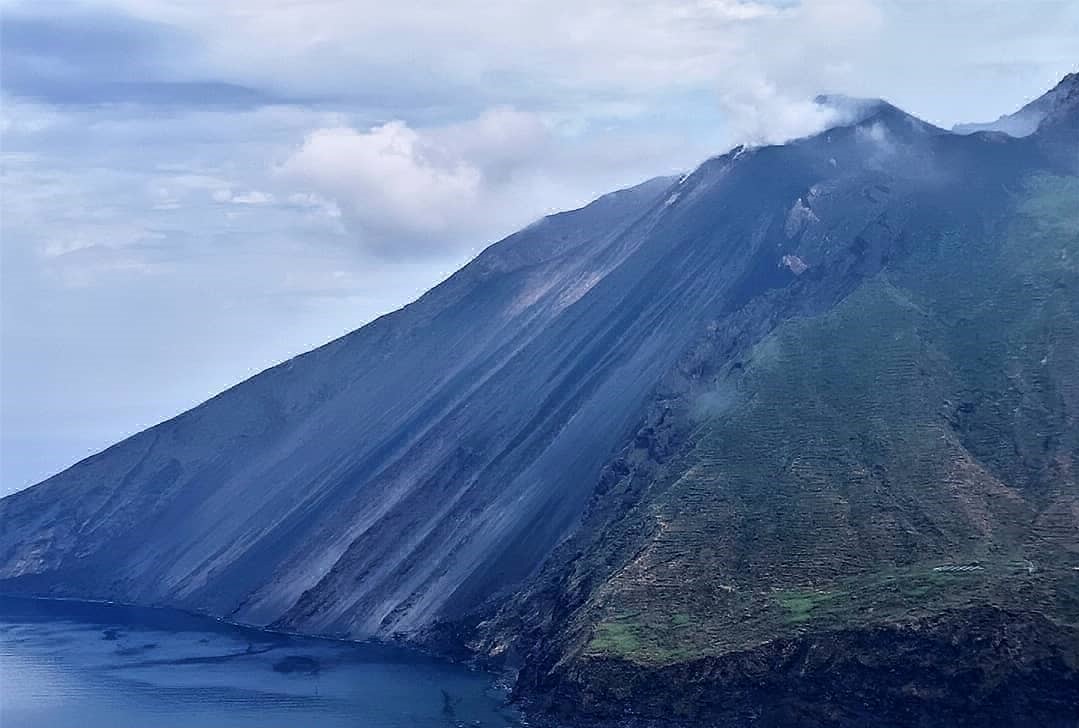
As for the explosive activity, it was produced at the same time by the two zones of the North and Center-South Crater (respectively N and CS) with a prevalence carried by the North zone compared to the Center-South. In detail, in the area of the North Crater (N) the N1 crater, with 2 emission points, produced explosions of varying intensity between high and medium with the launching of lapilli and bombs mixed with ash until at a height of about 200 meters. The N2 zone presented the same typicity in the eruptive style, associating a discontinuous and variable projection activity with episodic lava overflows of short duration. Up to 8 emission points were observed in the Center-South zone (CS), of which 2 were located in the South sector which produced an explosive eruptive activity of medium to high intensity (height of the projections up to approximately 200 m), with a predominant fraction of ash and secondary coarse material and 1 located in the central zone which produced discontinuous explosions of low intensity, but richer in coarse matter. The average weekly frequency of the total number of explosions / hour was about 9.4, with a partial of 6.4 and 3 respectively for zone N and CS.
Coupled with explosive activity, the North Crater area also produced three modest lava overflows from the N2 crater on June 21, 23 and 25 in conjunction with an intense splashing phase of this same N2 area. These phenomena produced lava flows that were no longer fed in a few hours and whose lava front was maintained in the upper part of the Sciara del Fuoco at an altitude of about 700 meters above sea level.
Source : INGV.
Photo : Massimiliano Privitera
Iceland , Geldingadalur / Fagradalsfjall :
The fissure eruption in the W part of the Krýsuvík-Trölladyngja volcanic system, close to Fagradalsfjall on the Reykjanes Peninsula, continued during 23-29 June. Lava fountaining and overflows from the fifth vent were periodically visible, and lava from the crater flowed in tubes as well as on the surface. The Institute of Earth Sciences noted that during 11-26 June the lava effusion rate averaged 13 cubic meters per second, which was high but similar to rates during May.
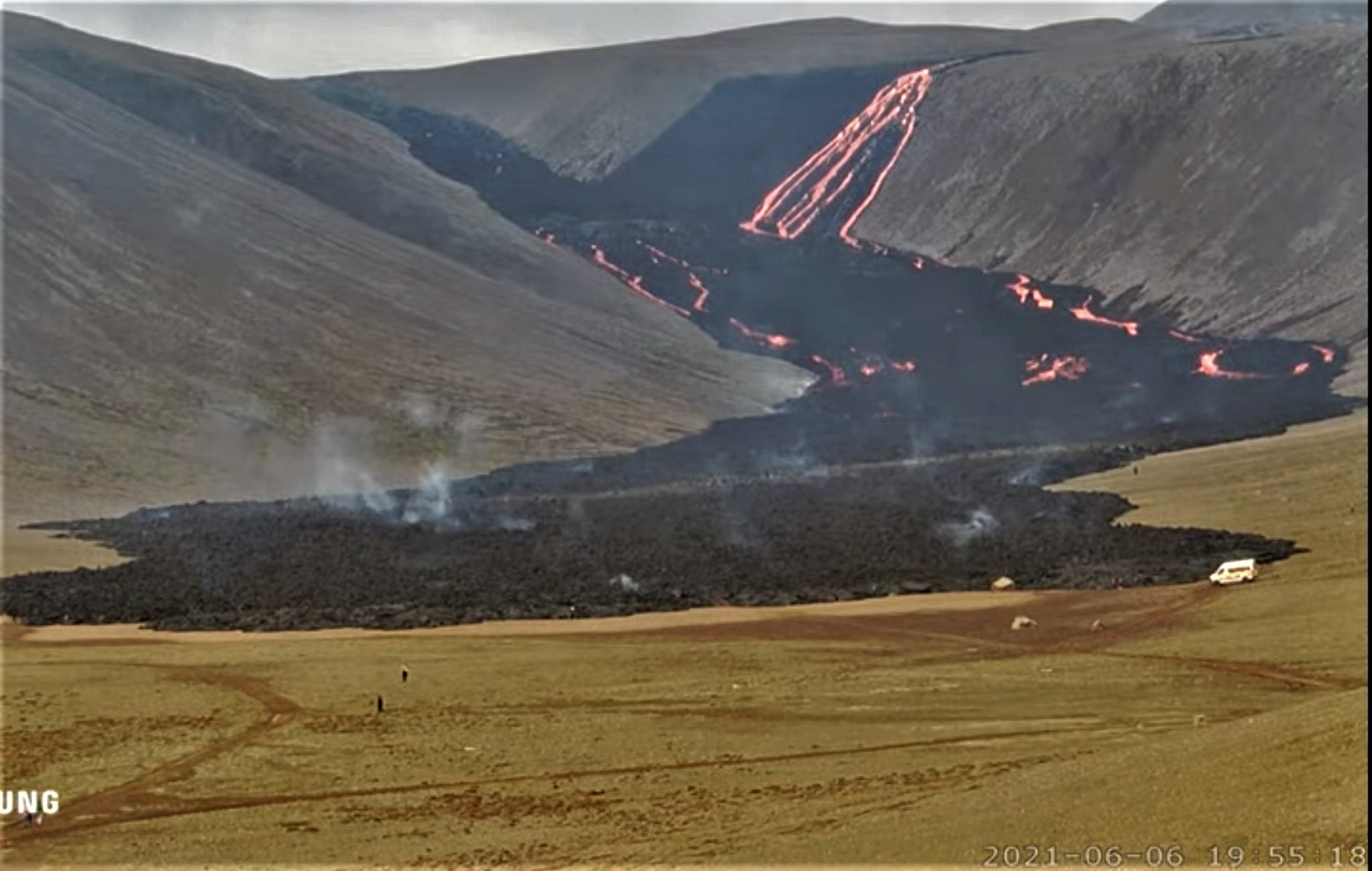
The area of the flow field had grown to 3.82 square kilometers, and the total volume erupted was 80 million cubic meters. Lava flows thickened 10-15 m in the Meradalir Valley, 15 m in the Nátthaga Valley, and 20 m in the S and E part of Geldingadalur. The Aviation Color Code remained at Orange due to the lack of ash and tephra emissions, though IMO warned of the potential for lapilli and scoria fallout within a 650 m radius of the active vent. Authorities warned of increased gas emissions hazards.
Source : GVP.
Photo : UNG
Philippines , Taal :
TAAL VOLCANO BULLETIN: 1 July 2021 08:00 A.M.
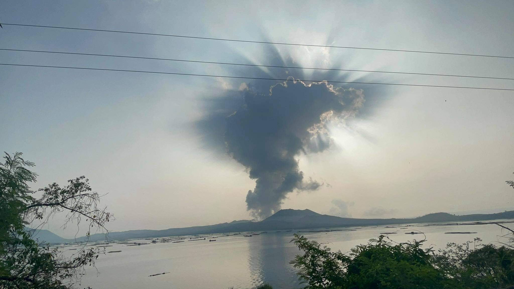
In the past 24-hour period, the Taal Volcano Network recorded ten (10) volcanic earthquakes, including eight (8) low frequency volcanic earthquakes and two (2) volcanic tremor events having durations of forty (40) to one hundred ten (110) seconds, and low-level background tremor that has persisted since 08 April 2021. High levels of volcanic sulfur dioxide or SO2 gas emissions and steam-rich plumes that rose as much as two thousand (2,000) meters high and drifted southwest have been observed from the Taal Main Crater. Sulfur dioxide (SO2) emission averaged 6,685 tonnes/day on 30 June 2021. In addition, vog was observed over Taal Caldera. Based on ground deformation parameters from electronic tilt, continuous GPS and InSAR monitoring, Taal Volcano Island has begun deflating in April 2021 while the Taal region continues to undergo very slow extension since 2020. These parameters indicate overall that magmatic unrest continues to occur at shallow depths beneath the edifice.
Alert Level 2 (Increased Unrest) is currently maintained over Taal Volcano. DOST-PHIVOLCS reminds the public that at Alert Level 2, sudden steam- or gas-driven explosions, volcanic earthquakes, minor ashfall, and lethal accumulations or expulsions of volcanic gas can occur and threaten areas within and around TVI. DOST-PHIVOLCS strongly recommends that entry must be strictly prohibited into Taal Volcano Island, Taal’s Permanent Danger Zone or PDZ, especially the vicinities of the Main Crater and the Daang Kastila fissure, and occupancy and boating on Taal Lake. Local government officials are advised to continuously assess and strengthen the preparedness of previously evacuated barangays around Taal Lake in case of renewed unrest. Civil aviation authorities must advise pilots to avoid flying close to the volcano as airborne ash and ballistic fragments from sudden explosions and wind-remobilized ash may pose hazards to aircraft. DOST-PHIVOLCS is closely monitoring Taal Volcano’s activity and any new significant development will be immediately communicated to all stakeholders.
In a special report issued on 28 June PHIVOLCS warned that public that the high levels of sulfur dioxide, the gas-and-steam plumes rising as high as 3 km above the lake’s surface, and weather conditions had caused vog over the Taal Caldera region. They issued another special statement on 29 June noting that on 28 June sulfur dioxide emissions averaged 14,326 tonnes/day, the highest rate ever recorded at Taal. Voggy conditions persisted, mainly impacting the NE and E lakeshore communities, with some residents reporting adverse effects.
Source : Phivolcs , GVP.
Photo : Seys Marasigan / Seys Channel
Hawaii , Kilauea :
19°25’16 » N 155°17’13 » W,
Summit Elevation 4091 ft (1247 m)
Current Volcano Alert Level: ADVISORY
Current Aviation Color Code: YELLOW
Activity Summary:
Kīlauea Volcano is no longer erupting. No surface activity has been observed by field crews or webcam images since May 23, 2021. Seismicity has slowly increased in recent weeks in the summit region, with continued gradual summit inflation over the past several months. Sulfur dioxide emission rates remain slightly elevated. It is possible that the Halema‘uma‘u vent could resume eruption or that Kīlauea is entering a longer period of quiescence prior to the next eruption.
Summit Observations:
The most recent sulfur dioxide (SO2) emission rates, measured on June 16, 2021, were 70 tonnes per day (t/d) (updated). SO2 emission rates are approaching levels associated with the non-eruptive period from late 2018 to late 2020 (30-35 t/d) and are significantly lower than emission rates that averaged over 800 t/d from mid-February to mid-April. Summit tiltmeters recorded three deflation-inflation cycles over the past week, along with continued gradual inflation in recent months. Seismicity has been slowly increasing in recent weeks, with a small swarm of earthquakes in the summit region on June 23.
Blue-tinged gases are seen above the lava lake in Halema‘uma‘u crater in this image taken from the southwest rim on June 25, 2021, at 12:37 p.m. HST. Although eruptive activity has paused at the summit of Kīlauea, sulfur dioxide-rich gases can still be seen emanating from the lava lake, primarily along the northern margin but also at the west vent and along the southern margin.
Halemaʻumaʻu Lava Lake Observations:
The lake’s surface is completely covered by solidified lava crust. No surface activity or evidence of recent surface activity has been observed over the past week.
East Rift Zone Observations:
No unusual activity noted in the region. Geodetic monitors indicate that the summit and upper East Rift Zone—between the summit and Puʻuʻōʻō—is refilling at rates similar to those measured over the past 2 years and before the December 2020 eruption. SO2 and hydrogen sulfide (H2S) emissions from Puʻuʻōʻō were below instrumental detection levels when last measured on January 7, 2021.
Source : HVO.
Photo: USGS / J.M. Chang.
Japan , Suwanosejima :
JMA reported that eruptive activity at Suwanosejima’s Ontake Crater increased during 21-23 June with multiple events. Eruptive events at 22h54 on 21 June and 00h04 on 23 June ejected large incandescent bombs 900 m NW and SE (respectively) from the crater; eruption plumes rose 1.2 km above the crater rim. The increased activity prompted JMA to raise the Alert Level to 3 at 00h15 on 23 June and warn the public to stay at least 2 m away from the active crater.
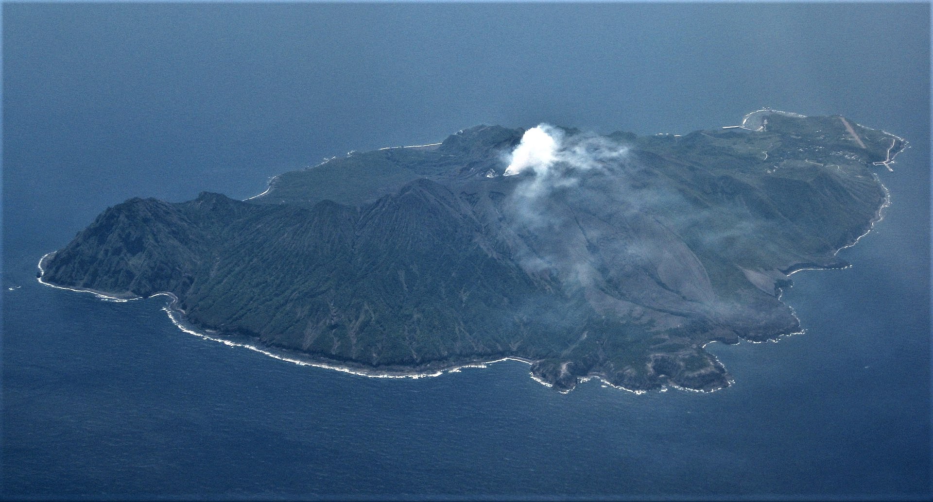
During an overflight on 23 June scientists noted incandescence on the crater floor and that there were several high-temperature deposits scattered in and around the crater. White plumes rose 200-300 m above the crater rim. Multiple eruptive events during 23-28 June ejected bombs 600 m and produced ash plumes that rose as high as 2.3 km.
Source : Japan Meteorological Agency (JMA) , GVP .
Photo : Ray Go.