February 11 , 2021.
Kamchatka , Karymsky :
VOLCANO OBSERVATORY NOTICE FOR AVIATION (VONA).
Issued: February 11 , 2021
Volcano: Karymsky (CAVW #300130)
Current aviation colour code: YELLOW
Previous aviation colour code: orange
Source: KVERT
Notice Number: 2021-22
Volcano Location: N 54 deg 2 min E 159 deg 26 min
Area: Kamchatka, Russia
Summit Elevation: 1486 m (4874.08 ft)
Volcanic Activity Summary:
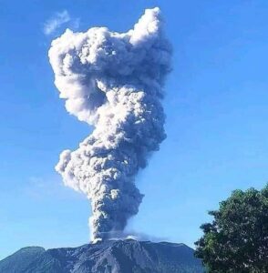
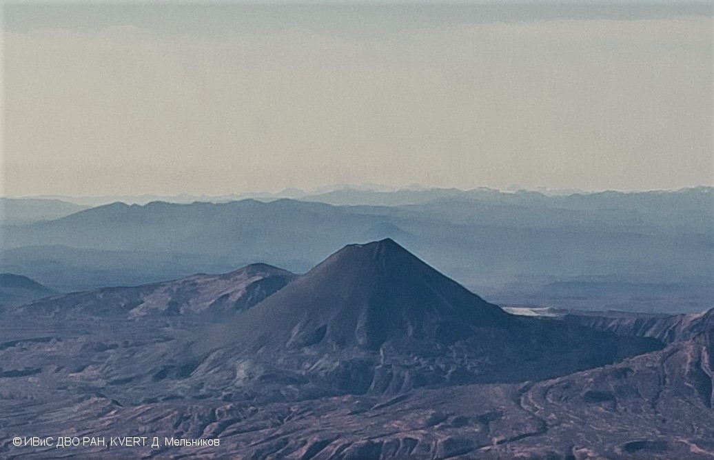
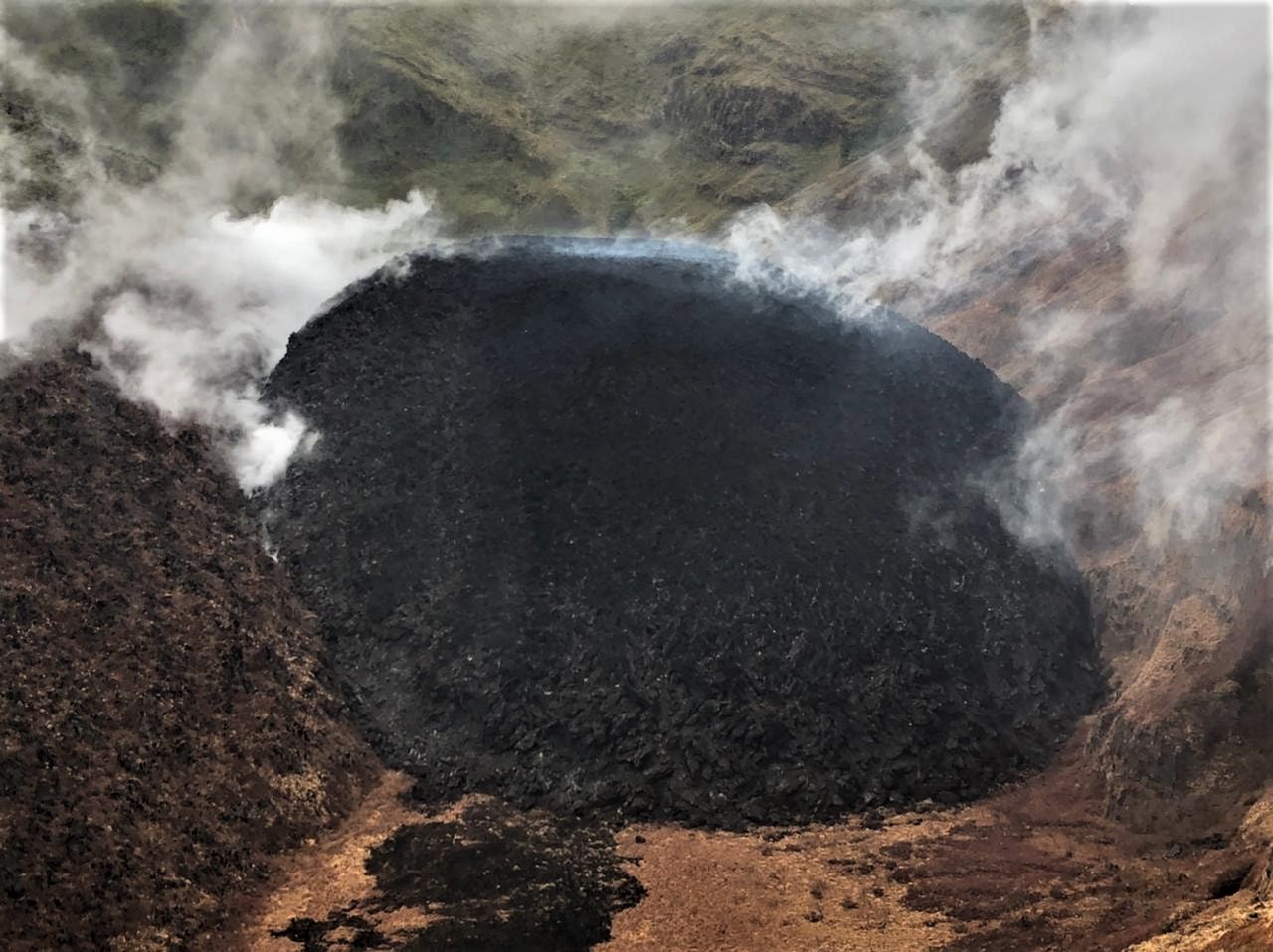
The activity of Karymsky volcano significantly decreased. Last strong ash explosions of the volcano up to 5.5 km a.s.l. were observed on 02 January, 2021. The thermal anomaly over the volcano was noted last time on 05 February, 2021.
A moderate gas-steam activity of the volcano continues. KVERT continues to monitor of Karymsky volcano.
A moderate gas-steam activity of the volcano continues. The danger of ash explosions up to 16,400-23,000 ft (5-7 km) a.s.l. is remains. Ongoing activity could affect low-flying aircraft.
Volcanic cloud height: NO ASH CLOUD PRODUSED
Other volcanic cloud information: NO ASH CLOUD PRODUSED
Source : Kvert.
Photo : D. Melnikov. IVS FEB RAS, KVERT.
Saint Vincent , Soufrière Saint Vincent :
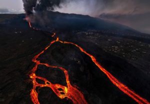
University of the West Indies Seismic Research Centre (UWI-SRC) and National Emergency Management Organisation (NEMO) reported that the lava dome in Soufrière St. Vincent’s main crater continued to grow during 1-9 February. Gas data analysis conducted during a field visit showed that sulfur dioxide emissions were first detected on 1 February, suggesting that ground water was drying up and no longer interacting with the gas species. The dome had an estimated volume of 5.93 million cubic meters. Scientists observed damaged vegetation, likely caused by fire, on the NW part of the crater (just N of the dome). A report on 6 February stated that the dome continued to spread laterally N and S, with N as the dominant growth direction.
Gas-and-steam continued to rise from the top of the dome as well as along the contact of the old and new domes. Scientists visited the Wallibou Hot Spring area on 7 February after a report of anomalously higher temperatures and gas odors; they collected water samples and took temperatures measurements for later analysis. Initial findings suggested the presence of hydrogen sulfide in that area and temperatures that had increased around 5-6 degrees; the lead scientist noted that based on their findings there was no increased risk associated with the hot springs. NEMPO reminded the public to avoid the volcano and that descending into the crater remained extremely dangerous. The Alert Level remained at Orange (the second highest level on a four-color scale).
The deformation network is functional. Successful hits of the Electronic Distance Measurement (EDM) target were recorded on the volcano rim from Richmond Vale, Troumaca, Rose Hall, Belmont, and Cherry Hill Chateaubelair. Base line data is being collected. The EDM Network is used to assist with measurements of deformation associated with the flanks of the volcano.
Sources : GVP , Nemo .
Photo : Nemo .
Japan , Asamayama :
On 5 February JMA lowered the Alert Level for Asamayama to 1 (on a scale of 1-5) noting that no deformation or crater incandescence had been detected since late November 2020, sulfur dioxide emissions had trended downward beginning in December, volcanic earthquakes were recorded only occasionally since mid-December, and the number of small-amplitude volcanic tremors were recorded occasionally and had not increased.

Asamayama, Honshu’s most active volcano, overlooks the resort town of Karuizawa, 140 km NW of Tokyo. The volcano is located at the junction of the Izu-Marianas and NE Japan volcanic arcs. The modern Maekake cone forms the summit and is situated east of the horseshoe-shaped remnant of an older andesitic volcano, Kurofuyama, which was destroyed by a late-Pleistocene landslide about 20,000 years before present (BP). Growth of a dacitic shield volcano was accompanied by pumiceous pyroclastic flows, the largest of which occurred about 14,000-11,000 BP, and by growth of the Ko-Asama-yama lava dome on the east flank. Maekake, capped by the Kamayama pyroclastic cone that forms the present summit, is probably only a few thousand years old and has an historical record dating back at least to the 11th century CE. Maekake has had several major plinian eruptions, the last two of which occurred in 1108 (Asamayama’s largest Holocene eruption) and 1783 CE.
Source: GVP , Japan Meteorological Agency (JMA)
Photo :
Ecuador , Sangay :
DAILY REPORT OF THE STATE OF SANGAY VOLCANO, Wednesday February 10 , 2021.
Surface activity level: High, Surface trend: No change.
Internal activity level: High, Internal trend: No change.
Seismicity: From February 09, 2021, 11:00 a.m. to February 10, 2021, 11:00 a.m .:
Long period type events (LP): 57
Explosions (EXP): 201
Emission tremor (TREMI): 5
Harmonic tremor: (TRARM): 3
Rains / lahars:
No rainy episodes were recorded in the area.
** In the event of heavy rains, they could re-mobilize the accumulated materials, generating mudslides and debris that would descend the sides of the volcano and flow into the adjacent rivers. **
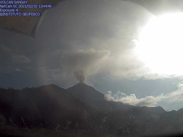
Emission / ash column: Several gas emissions were observed which reached heights of up to 1000 meters above the crater level, the direction of these emissions varied between the North, the South and the South-East. The VAAC recorded 5 ash emission alerts observed by satellites that reached heights of 1,200 and 1,800 meters above crater level, dispersing in south-eastern and north-western directions. There is a report of possible presence of ash in the North and West of Macas.
Other monitoring parameters: FIRMS reported 47 thermal alerts on the Sangay in the last 24 hours.
MIROVA reported 3 thermal alerts (one strong, one moderate and one weak) on the Sangay in the last 24 hours.
Observations: On images shared from ECU911, over the past 24 hours, the volcano has been cleared several times, allowing us to observe the emissions described above. At night, incandescent materials were observed, rolling on the south-eastern side of the volcano. This morning, the possible presence of ash was reported in the environment north and west of Macas.
Alert level: yellow.
Sources : INSTITUT GÉOPHYSIQUE / ÉCOLE NATIONALE DE POLYTECHNIQUE.