April 26 , 2021 .
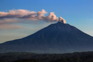
Japan , Sakurajima :
The volcano Sakurajima in southwestern Japan erupted early Sunday, sending a column of smoke over 2.3 kilometers into the air, the weather agency said.
Following the eruption at 1:09 a.m., the Meteorological Agency issued an alert, urging people in the cities of Kagoshima and Tarumizu in Kagoshima Prefecture to protect themselves from any potential impact. There were no reports of injuries or property damage following the eruption, local authorities said.
Although pyroclastic flows were confirmed within 1.8 km of the Minamidake crater, the agency said the likelihood of death or injury is low since people have been prohibited from approaching areas within 2 km of the crater since February 2016.
The agency is maintaining its alert for the volcano at level 3 on a 5-point scale, warning the public not to go near the crater and urging caution against falling rocks and stones and pyroclastic flows beyond the 2-km radius.
The agency later expanded the no-entry zone to a 2.4-km radius from the Minamidake crater. The nearest residential area is about 2.5 km away.
Sakurajima, an area that has one of the most active volcanoes in Japan, is connected to the Osumi Peninsula on Kyushu, the country’s southwestern main island.
A large eruption in 1914 emitted enough lava to close the strait between the Sakurajima volcanic island in Kagoshima Bay and the Osumi Peninsula.
Source : japantimes.co
Photo : Kyodo.
Read the article : https://www.japantimes.co.jp/news/2021/04/25/national/sakurajima-volcano-eruption/?fbclid=IwAR2ZTMoHoR4MA3blMseTonQMWppF0OtS_yJVTws1MKRzcgSmQyULRUqOdUQ
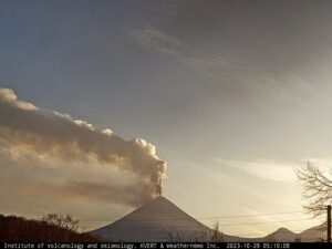
La Réunion Island , Piton de la Fournaise :
Press release of April 25, 2021 – 12:30 p.m.
The eruption that started on 04/09/2021 at 7 p.m. (appearance of the tremor) continues. The intensity of the volcanic tremor (indicator of a surface lava emission) has been stable for ten days.
– No direct observation of the eruptive site could be made today given the very bad weather conditions on the volcano this morning. For additional information, the OVPF rain gauge located north of the summit of Piton de la Fournaise recorded 40 mm of rain this morning between 4 a.m. and 12 p.m. (local time).
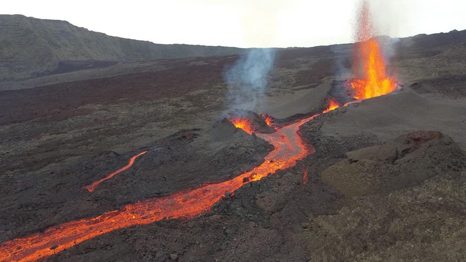
– Over the last 24 hours, 8 superficial volcano-tectonic earthquakes (between sea level and the surface) have been recorded under the summit craters.
– The CO2 fluxes in the soil are still increasing both in the far field (Plaine des Cafres and Plaine des Palmistes) and in the near field (Gîte du volcano).
– Averaged over the past few days, no significant trend can be seen in the deformations of the building (neither in deflation nor in inflation). It could suggest a flow of magma
deep entering the superficial magmatic reservoir equivalent to the outlet flow of the reservoir which feeds the eruptive site.
Source : OVPF.
Read the article: https://www.ipgp.fr/sites/default/files/ovpf_20210425_12h30_communique_eruption.pdf
Photo : OVPF
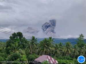
Philippines , Taal :
TAAL VOLCANO BULLETIN 26 April 2021 08:00 A.M.
In the past 24-hour period, the Taal Volcano Network recorded fifty-six (56) volcanic earthquakes, including thirty-five (35) volcanic tremors having durations of one (1) minute to eighteen (18) minutes, twenty-one (21) low frequency volcanic earthquakes, and low-level background tremor that started at 9:05 AM on 08 April 2021. Activity at the Main Crater consisted of weak emission of steam-laden plumes from fumaroles or gas vents that rose to ten (10) meters.
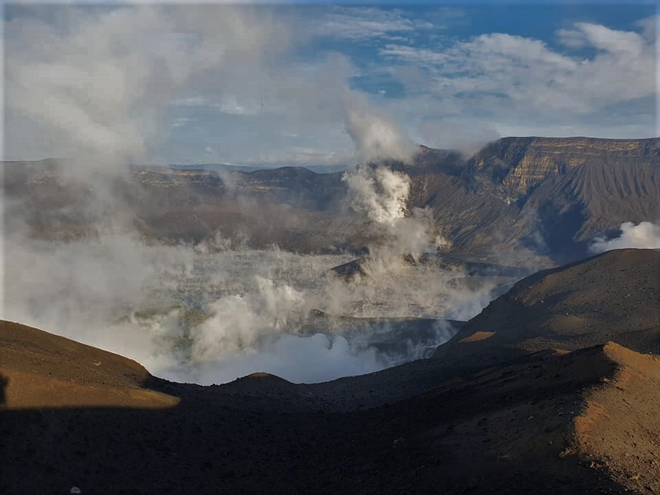
Sulfur dioxide (SO2) emission averaged 701 tonnes/day on 25 April 2021. Temperature highs of 71.8°C and pH of 1.59 were last measured from the Main Crater Lake respectively on 04 March and 12 February 2021. Ground deformation parameters from electronic tilt, continuous GPS and InSAR monitoring continue to record a very slow and steady inflation and expansion of the Taal region that began after the January 2020 eruption. These parameters indicate persistent magmatic activity at shallow depths beneath the edifice.
Source : Phivolcs.
Photo : William Enriquez
Chile / Argentina, Nevados of Chillan :
Seismicity parameters associated with rigid material fracturing (VT) processes showed a slight increase in quantity and energy, as did the energy of events related to fluid dynamics (LP and EX types), while the quantity and energy showed a slight decrease in the case of tremor-type events (TR).
The highest energy VT-type event, with a local magnitude (ML) of 4.1, was located 1.9 km northeast (NNE) of the active crater and at a depth of 3.8 km.
The analysis of the images provided by the surveillance cameras belonging to the OVDAS, as well as the analysis of the satellite images, deduced that the advance of the lava flow, at a speed of 0.1 m / h, had an estimated range of 938 m. The explosive activity exhibited maximum column heights of 760 m, with low particulate content. It is seen that in recent weeks, the growth of the dome nestled in the crater has concentrated its growth towards the edges, showing a depressed morphology in its center.
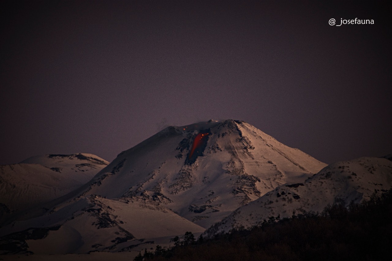
An estimated volume for the dome is estimated at 411,978 m³ and a total extruded volume (June 2020-present) of 2,329,876 m³, calculated based on digital elevation models.
When the weather conditions allowed it, it was possible to record the nocturnal incandescence associated with the explosions in a recurrent and focused manner in the East zone (E) of the crater.
According to data obtained from the network of GNSS stations and inclinometers installed on the volcano, a slight inflationary trend was observed.
Six (6) thermal alerts were recorded in the area with a maximum value of 8 MW, considered moderate for this volcano. In turn, radiation anomalies were detected on April 3, 5, 8, 10, 13 and 15 from Sentinel 2-L2A image analysis.
There was no increase in the mean temperature observed for the lava flow during this period.
Source : Segemar .
Photo : Josefauna.
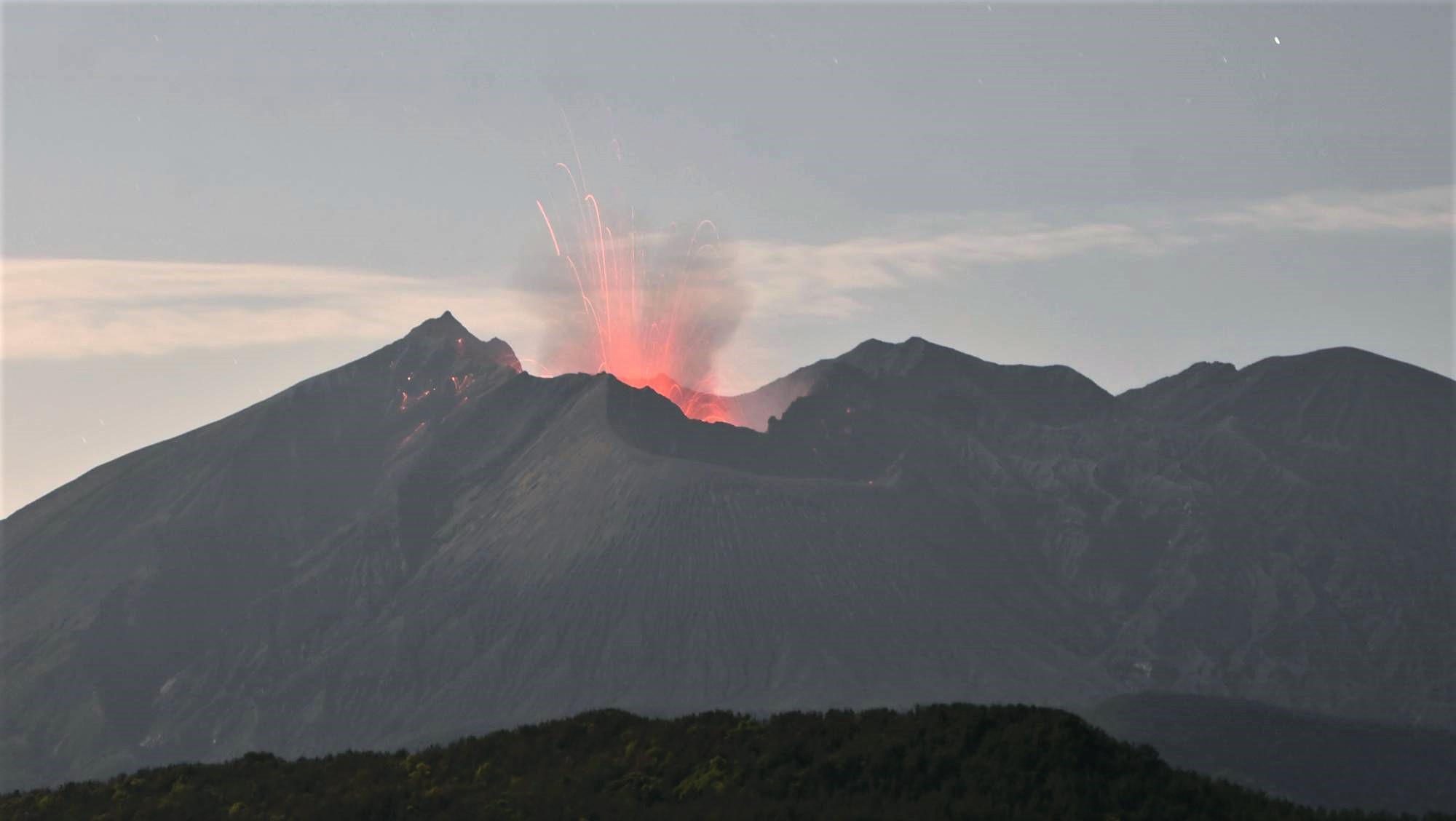
Saint Vincent , Soufrière Saint Vincent :
La Soufrière, St Vincent SCIENTIFIC UPDATE – 25/04/21 6:00PM
– Seismic activity at La Soufrière, has remained low since the tremor associated with the explosion and ash venting around noon on 22 April.
– In the last 24 hours, only a few long-period, hybrid and volcano-tectonic earthquakes have been recorded and there was no further tremor.
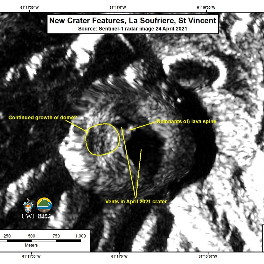
– Satellite radar imagery acquired on 24th April indicates probable continued growth or formation of a lava dome following the explosions on 18 and 22 April.
– The volcano continues to erupt and is still dangerous.
– Its pattern of seismic activity over the last few days is typical of the growth of a lava dome.
– Explosions with accompanying ashfall, of similar or larger size can restart with little or no warning.
– The volcano is at alert level Red.
Evolution of the La Soufriere eruption shown here by the ALOS-2 radar images from January 13th to April 21, 2021. We can see the lava dome that emerged in Dec 2020, elongate to a form a coulee and the last image of it is from April 7th, two days before the 1st explosion was observed.
The April 21st image shows that both the old and new dome have been destroyed and a new crater has formed as shown in previous images.
The eruption continues and we will continue to share the rich satellite imagery we have been able to access to observe the volcano.
Source : UWI