October 30 , 2023.
Iceland , Reykjanes Peninsula :
Ground uplift continues northwest of Þorbjörn . Complex volcano-tectonic unrest is affecting the Reykjanes Peninsula . Updated 29th of October at 2pm
The latest cGPS deformation data around the Þorbjörn and Svartengi area confirm that the deformation, which started 27 October, continues. As initially stated, the ongoing deformation rates are higher than in previous events which occurred in a similar area in 2020 and 2022. Overall, the seismicity north of Grindavík has been declining over the past 24 hours and there are no significant changes in earthquake depths. However, it is important to emphasise that the current deformation may trigger renewed seismicity in the area that could be felt by people.
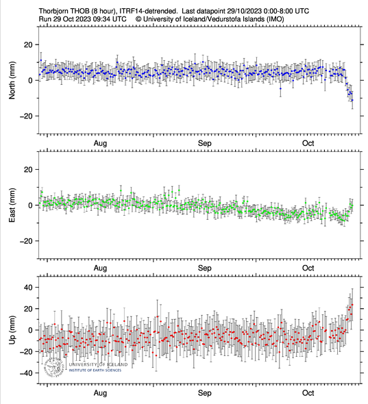
8-hours solution for the cGNSS THOB station in Þorbjörn showing the latest data point updated at 08:00 UTC today, October 29th.
New satellite data are expected to be delivered later today, and a new interferogram will be processed as soon as the data are available. The results will allow us to identify and interpret the deformation processes that have occurred on the peninsula over the past 12 days. We expected to publish the results tomorrow.
An episode of complex volcano-tectonic unrest is currently affecting the Reykjanes Peninsula. It is interpreted to result from multiple deformation sources at depth, which are interacting and affecting a wide area across the peninsula.
Source et photo : IMO.
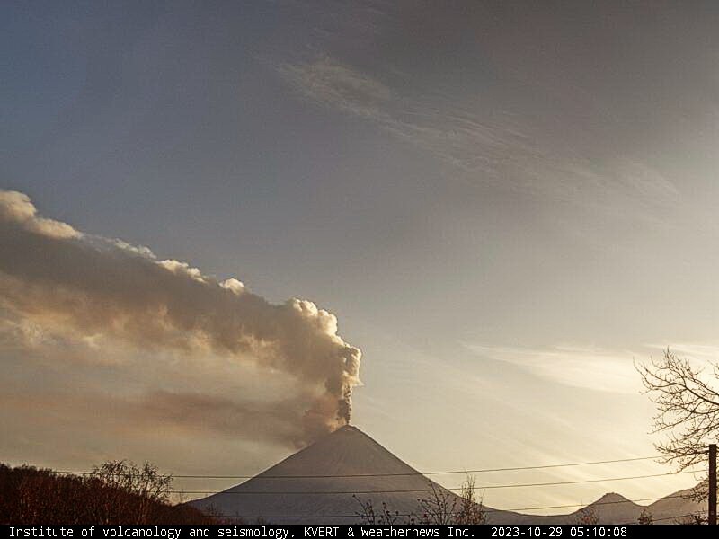
Kamchatka , Klyuchevskoy :
VOLCANO OBSERVATORY NOTICE FOR AVIATION (VONA)
Issued: October 30 , 2023
Volcano: Klyuchevskoy (CAVW #300260)
Current aviation colour code: ORANGE
Previous aviation colour code: orange
Source: KVERT
Notice Number: 2023-135
Volcano Location: N 56 deg 3 min E 160 deg 38 min
Area: Kamchatka, Russia
Summit Elevation: 4750 m (15580 ft)
Volcanic Activity Summary:
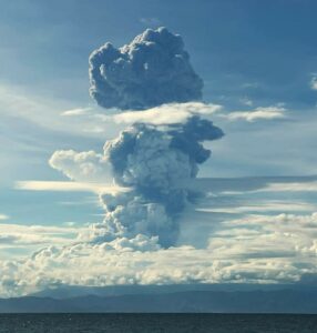
The summit explosive-effusive eruption of the volcano continues. Against the background of explosive activity of the Strombolian type (lava fountaining in the volcanic crater up to 500 m), the lava flow continue to effuse alternately along the Apakhonchichsky chute on the southern slopes of the volcano. Satellite data by KVERT showed an ash plume, containing mainly old deposits from collapses in Apakhonchichsky chute, is extending for 32 km to the north-east of the volcano.
The summit explosive-effusive eruption of the volcano continues. Ash explosions up to 7-8 km (23,000-26,200 ft) a.s.l. could occur at any time. Ongoing activity could affect international and low-flying aircraft.
Volcanic cloud height:
7500-8000 m (24600-26240 ft) AMSL Time and method of ash plume/cloud height determination: 20231029/2350Z – Video data
Other volcanic cloud information:
Distance of ash plume/cloud of the volcano: 32 km (20 mi)
Direction of drift of ash plume/cloud of the volcano: NE / azimuth 37 deg
Time and method of ash plume/cloud determination: 20231029/2350Z – Himawari-9 14m15
Source et photo : Kvert
Hawaii , Kilauea :
Sunday, October 29, 2023, 9:02 AM HST (Sunday, October 29, 2023, 19:02 UTC)
19°25’16 » N 155°17’13 » W,
Summit Elevation 4091 ft (1247 m)
Current Volcano Alert Level: ADVISORY
Current Aviation Color Code: YELLOW
Activity Summary:
Kīlauea volcano is not erupting. The unrest to the south-southwest of Kīlauea’s summit has continued over the past 24 hours, with a slight decrease in seismicity, in association with an intrusive event that began in early October. Unrest may continue to wax and wane with changes to the input of magma into the area. The summit of Kīlauea remains at a high level of inflation and eruptive activity is possible in the coming weeks or months. No unusual activity has been noted along Kīlauea’s East Rift Zone or the Southwest Rift Zone.
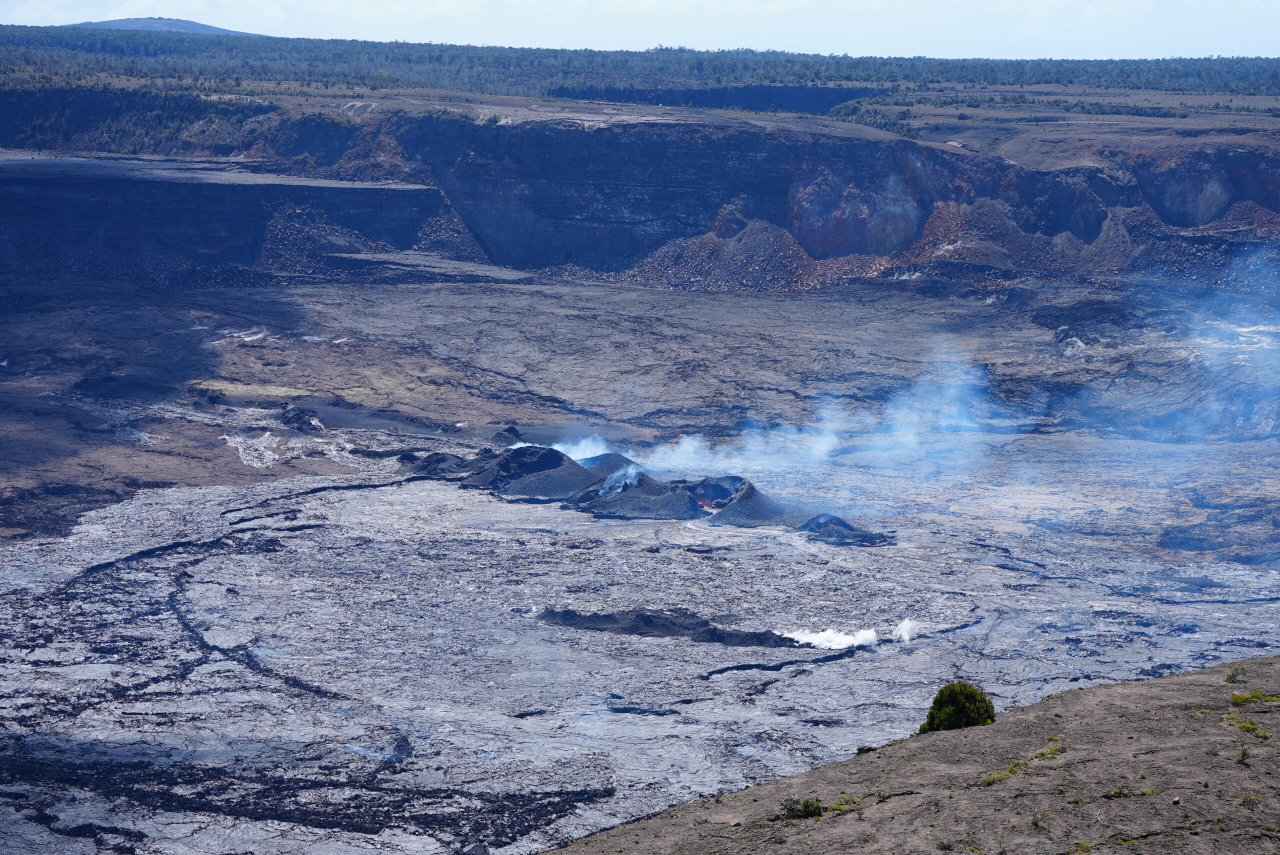
Summit Observations:
Unrest to the south and southwest of the summit area of Kīlauea continued over the past day with a slight decrease in seismicity. Waxing and waning of unrest may continue.
Elevated seismicity (a seismic swarm) associated with an intrusion beneath the south-southwest region of Kīlauea’s summit began in early October. Since then, swarm activity has varied, with the greatest number of earthquakes occurring on October 4-6, 16-18, 21-23, and 26-28. Over the past 24 hours, swarm activity continued to slightly decrease, with approximately 74 earthquakes recorded in Kīlauea’s summit region, a decrease from 89 over the previous 24 hours. Most of the earthquakes related to this unrest have been smaller than magnitude-2 and have occurred at depths of around 1–3 km (0.6–2 mi) below the surface.
The Uēkahuna summit tiltmeter, located northwest of the caldera, has been mostly stable over the past 24 hours. The Sand Hill tiltmeter, located southwest of the caldera, has been mostly stable over the past 24 hours, and continues to record gradual yet sustained uplift. Overall, inflation at the summit of Kīlauea remains high and has surpassed the level seen just before the most recent eruption on September 10. However, the current rate of inflation in the region has diminished significantly since October 4-6.
Sulfur dioxide (SO2) emission rates remain low and were measured at a rate of about 100 tonnes per day on October 19.
Source : HVO
Photo : USGS/ M. Patrick.
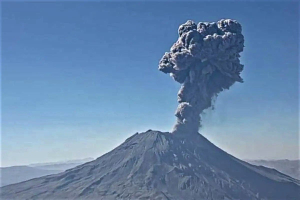
Peru , Ubinas :
ACTIVITY OF THE DAY
Low to moderate level eruptive process:
Gas emissions up to 100 m high above the summit of the volcano.
6 earthquakes linked to the movement of magma and gases.
Slight swelling of the volcano surface (5 mm).
SCOPE OF VOLCANIC PRODUCTS
Dispersion of gases towards the Northeast sector, towards the district of Ubinas and the populated centers of said sector, as well as ranches and grazing areas.
The approximate impact radius after today’s broadcasts is less than 5 km from the crater, i.e. within the range of the volcano.
RECOMMENDATIONS
Adopt preventive measures according to the orange volcanic alert level in which the Ubinas volcano is located.
Do not approach within 4 km of the crater.
The population must remain vigilant in the face of possible ash falls and follow the recommendations made by the Civil Defense authorities.
Source : Cenvul
Photo : ingemmet
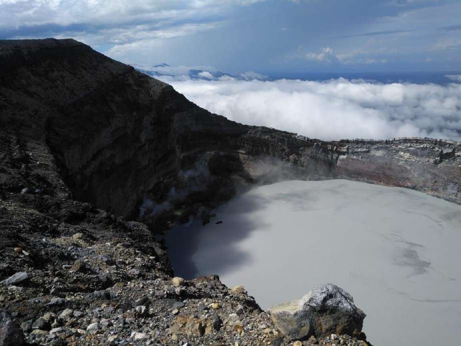
Costa Rica , Rincon de la Vieja , Poas :
Rincon de la Vieja Volcano:
Latitude: 10.83°N;
Longitude: 85.34°W;
Altitude: 1916 m above sea level.
Current activity level: Caution
Possible manifestations: Small eruptions, bubble or geyser, significant gas emission, temperature rise (incandescence), seismic swarms or volcanic tremor, slight inflation-extension of the volcanic structure, hot springs.
The predominantly exhalatory phreatic activity continues during this week. 23 exhalations and three small eruptions were recorded. None of them were associated with a lahar or ash emission. The appearance of long period (LP) type signals continues, some of them being intense in seismic energy, in addition to the background tremor, which is observed mostly continuous and variable in amplitude, with a wide range of frequencies (0.5 – 8 Hz). Signals associated with fractures (VT) near the summit and base of the volcano are also recorded. Regarding the deformation detected by GNSS equipment, the elevation of the volcano’s summit continues to be observed, accumulating 2.5 cm since August, which is relatively high. On a global scale, higher inflation has been observed in recent months, higher than that in the first months of the year. Based on data from December 2022 to date, a source can be located, approximately 5 km ± 2.5 km below sea level, with an accumulation of magmatic fluids of several million cubic meters. It should be noted, however, that these models carry significant uncertainty.
The CO2/SO2 ratio measured in the plume remains low with a weekly average of 1.9 ± 0.19 and the H2S/SO2 ratio is 0.31 ± 0.30. These values suggest a shallow magma source and open conduits. Since the previous week, a significant increase in SO2 flow was observed up to 257 ± 45 t/d as the average SO2 flow.
Poas Volcano:
Latitude: 10.20°N;
Long: 84.23°W;
Altitude: 2687 m above sea level.
Current activity level: Warning
Possible manifestations: Small eruptions, bubble or geyser, significant gas emission, temperature rise (incandescence), seismic swarms or volcanic tremor, slight inflation-extension of the volcanic edifice.
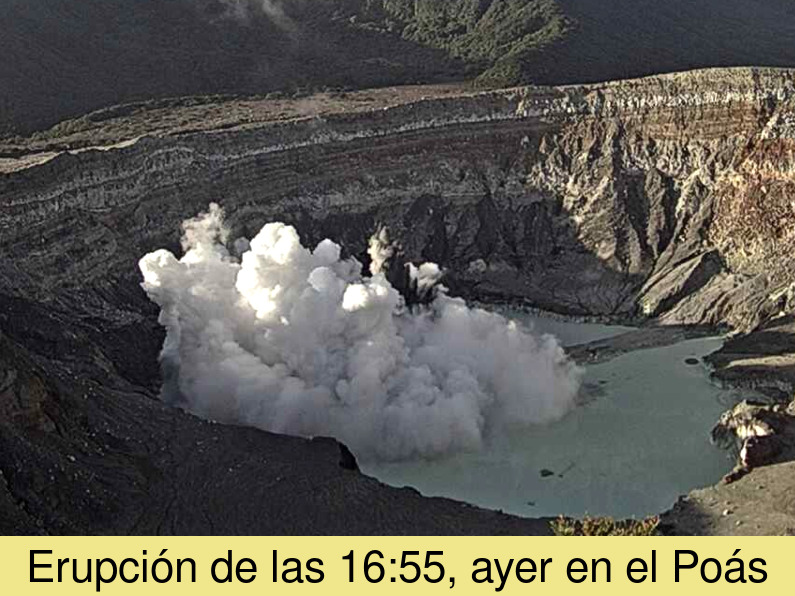
Seismographs continue to record a continuous background volcanic tremor signal with amplitude variations, in the form of spasmodic tremors, in a band of dominant frequencies between 2 and 6 Hz, and occasionally with tremors of frequencies close to 8 and 10 Hz. They also recorded low frequency volcanic earthquakes. On October 26, at 4:55 p.m., a small hydrothermal eruption was recorded, located in the center of the lagoon, which lifted material from the bottom of the lake to a height of 50 meters. The previous week, the SO2 flow showed a value of 75 ± 92 t/d. This has remained consistent over the past two weeks. The gas ratios measured in the plume remain within normal ranges with weekly averages of SO2/CO2 = 0.76 ± 0.13 and H2S/SO2 <0.01, values similar to the previous week. The ExpoGAS gas sensor located at Visitor Viewpoint detected a maximum of 5.5 ppm SO2 this week, with a weekly average of 0.2 ppm. The lake level has fallen by 40 cm this week.
Source : Ovsicori
Photos : Waldo Taylor/ ICE. , Ovsicori ( archive 2023.)