February 28 , 2021 .
Italy / Sicily , Etna :
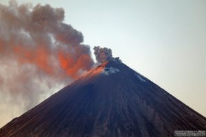
Etna serial , continuation: new climax.
COMMUNICATION ON THE ACTIVITY OF ETNA, February 28, 2021, 09:10 (08:10 UTC)
The National Institute of Geophysics and Volcanology, Osservatorio Etneo, announces that from 7:39 GMT there is an increase in Strombolian activity at the Southeast Crater.
In particular, there are two active vents where Strombolian activity is concentrated. The activity is presented with a single continuous jet, passing through a lava fountain, the height reached by this activity is about 300 m.
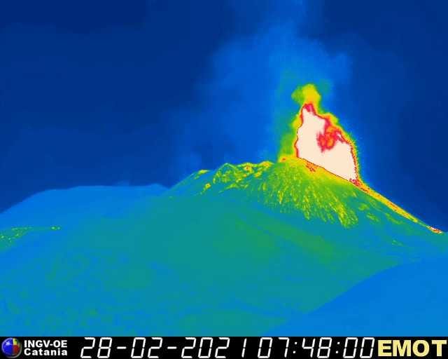
COMMUNICATION ON THE ACTIVITY OF ETNA, February 28, 2021, 09:30 (08:30 UTC)
The National Institute of Geophysics and Volcanology, Osservatorio Etneo, announces that in addition to the previous press release, the amplitude of the tremor has reached high values. The sources are located under the Southeast Crater at a depth of about 2500 m above sea level. The infrasound activity is also high both in terms of the rate of occurrence and the energy of events. The sources of the events are located in correspondence with the Southeast Crater. Analysis of the data from the Etna GNSS network does not show any significant variations.
VOLCANO OBSERVATORY NOTICE FOR AVIATION (VONA).
Issued: February 28 , 2021
Volcano: Etna 211060
Current Color Code: RED
Previous Color Code: red
Source: Etna Volcano Observatory
Notice Number: 2021/0027/06C06
Volcano Location: 3744N 01500E
Area: Italy
Summit Elevation: 3300 m
Volcanic Activity Summary:
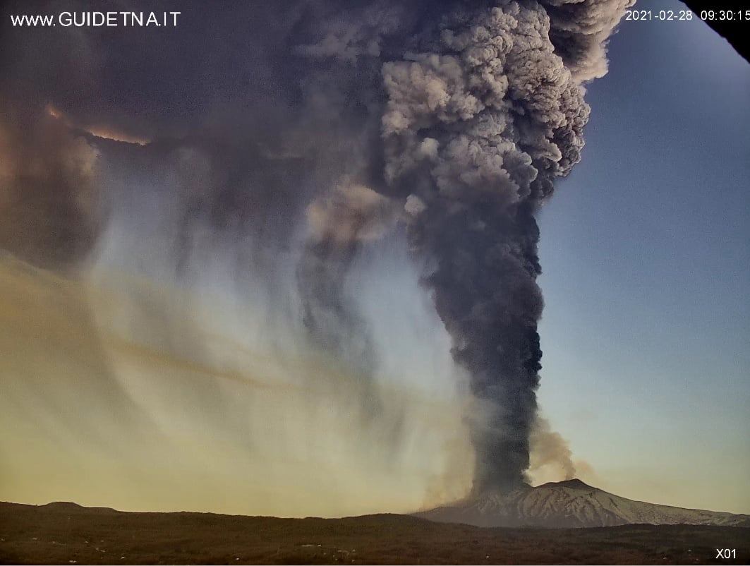
LAVA FOUNTAIN IS OBSERVED AT SUMMIT CRATERS
Volcanic cloud height:
EXTIMATED VOLCANIC CLOUD HEIGHT IS MORE THAN 9 KM AT THE TOP; DATA FROM SURVEILLANCE CAMERA
Other volcanic cloud information: ASH CLOUD MOVES TOWARD E
Remarks: THE PHENOMENON IS OBSERVED BY VISIBLE AND THERMAL SURVEILLANCE CAMERAS
Source : INGV .
Kamchatka , Ebeko :
VOLCANO OBSERVATORY NOTICE FOR AVIATION (VONA).
Issued: February 27 , 2021
Volcano: Ebeko (CAVW #290380)
Current aviation colour code: ORANGE
Previous aviation colour code: orange
Source: KVERT
Notice Number: 2021-32
Volcano Location: N 50 deg 41 min E 156 deg 0 min
Area: Northern Kuriles, Russia
Summit Elevation: 1156 m (3791.68 ft)

Volcanic Activity Summary:
A moderate eruptive activity of the volcano continues. According to visual data by volcanologists from Severo-Kurilsk, explosion sent ash up to 2.5 km a.s.l., an ash cloud is drifting to the southwest of the volcano.
A moderate eruptive activity of the volcano continues. Ash explosions up to 6 km (19,700 ft) a.s.l. could occur at any time. Ongoing activity could affect low-flying aircraft and airport of Severo-Kurilsk.
Volcanic cloud height:
2500 m (8200 ft) AMSL Time and method of ash plume/cloud height determination: 20210227/0204Z – Visual data
Other volcanic cloud information:
Distance of ash plume/cloud of the volcano: 3 km (2 mi)
Direction of drift of ash plume/cloud of the volcano: SW
Time and method of ash plume/cloud determination: 20210227/0204Z – Visual data
Source : Kvert .
Photo : S. Lakomov.
Indonesia , Merapi :
Mount Merapi Activity Report, February 19-25, 2021.
I. OBSERVATION RESULTS
Visual
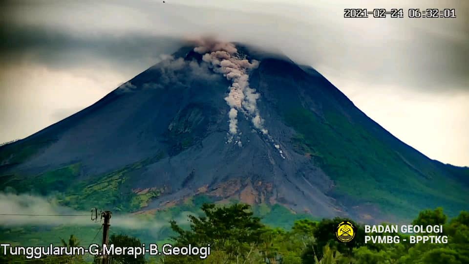
The weather around Mount Merapi is generally sunny in the morning, while the afternoon until evening is foggy. The smoke emitted is white, weak to thick with low pressure. A maximum smoke height of 400 m was observed from the Ngepos observation post on February 19, 2021 at 6:40 a.m. WIB.
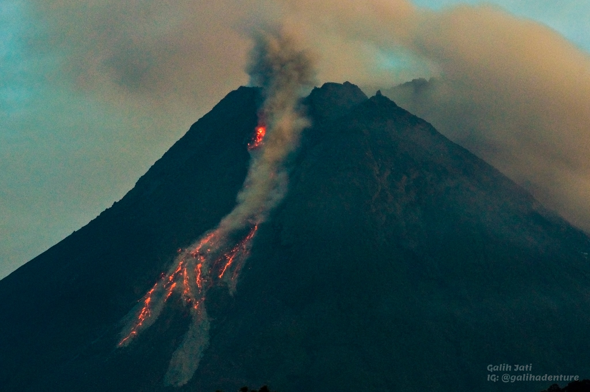
Hot cloud avalanches occurred 3 times with a maximum slide distance estimated at 1900 m to the southwest and recorded on a seismogram with a maximum amplitude of 51 mm and a duration of 175 seconds. The hot cloud avalanche on February 25, 2021 at 4:52 p.m. WIB caused a light shower of ash in Kali Tengah Lor, Kali Tengah Kidul, Deles and Tlukan. A clear visual of avalanche clouds was observed on February 24 at 06:31 WIB.
Morphological analysis of the peak area based on photos of the southwest sector from February 25 to February 17, 2021 showed a change in the morphology of the peak area due to effusion activity and growth. of the dome. The volume of the lava dome in the southwest sector is 618,700 m3 with a growth rate of 13,600 m3 / day.
Seismicity
This week, the seismicity of Mount Merapi recorded:
3 hot cloud avalanches (AP),
14 multi-phase earthquakes (MP),
985 avalanche earthquakes (RF),
37 emissions earthquakes (DG)
5 tectonic earthquakes (TT).
In general, internal seismicity this week has been lower than last week, while surface earthquakes such as avalanche earthquakes have increased and hot clouds are emerging from avalanches.
Deformation
The deformation of Mount Merapi which was monitored using EDM and GPS this week showed no significant changes.
Rain and lahars
This week there was rain at the Mount Merapi observation post with the highest rainfall intensity of 15mm / hour for 40 minutes at the Ngepos post on February 19, 2021. There were no lahars or additional flow in the rivers that descend from Mount Merapi.
Conclusion
Based on the results of visual and instrumental observations, it is concluded that:
The volcanic activity of Mount Merapi is still quite high in the form of effusive eruption activity. The status of the activity is defined at the “SIAGA” level.
Source : BPPTKG.
Photos : BPPTKG , Yohannes Tyas Galih Jati .
Hawaii , Kilauea :
19°25’16 » N 155°17’13 » W,
Summit Elevation 4091 ft (1247 m)
Current Volcano Alert Level: WATCH
Current Aviation Color Code: ORANGE
Activity Summary:
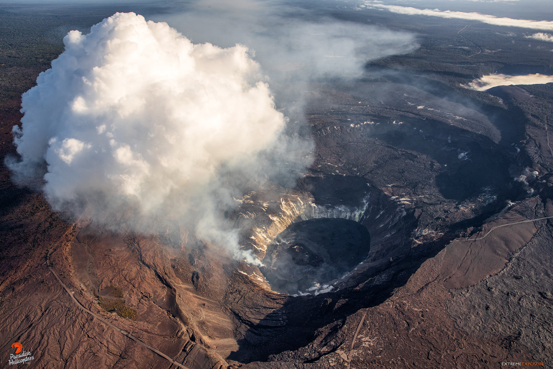
Kīlauea Volcano is erupting. Lava activity is confined to Halemaʻumaʻu with lava erupting from a vent on the northwest side of the crater. Laser rangefinder measurements as of this morning, February 27, indicate the lava in the western (active) portion of the lake in Halema‘uma‘u is 217 m (715 ft) deep. Webcams show intermittent crustal foundering. The eastern portion of the lava lake has a stagnant and solidified surface crust. SO2 emission rates remain elevated; measurements on February 26 were 700 t/day.
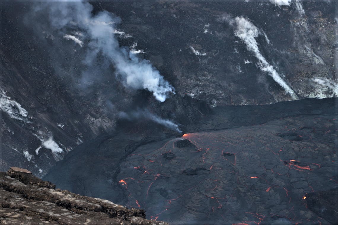
The lava lake in Halema‘uma‘u crater, at the summit of Kīlauea, remains active. Active surface lava remains limited to the western portion of the lake, shown here as seen from the south rim of the crater and looking towards the northwest. The western fissure cone is in the center of the photo. The top of the main cone is obscured by volcanic gases, and a small glow area is visible at the tip of a vent slightly north (right) of the main cone. Lava enters the lake at the base of the western fissure cone in incandescent area.
Summit Observations:
The most recent sulfur dioxide emission rate measurements from February 26 are about 700 t/d — this rate is lower than the emission rates from the pre-2018 lava lake (around 5,000 t/d). The summit tiltmeters continue to show deflation after the start of a DI event on 2/24 with only minor deflation since midnight. Seismicity remains stable, with elevated tremor.
As hot gases rise from Halema‘uma‘u’s west vent, the cooler temperatures of the atmosphere causes the water vapor to condense, creating a vapor cloud over the Kīlauea’s lava lake.
Halemaʻumaʻu lava lake Observations:
Lava from the west vent continues to supply the lava lake within Halema‘uma‘u crater.
The active western half of the lava lake was approximately 217 m (715 ft) deep as measured by remote laser rangefinder on the morning of February 27, 2021.
Observations yesterday afternoon indicated lava effusion continues at the western fissure. The lava rapidly develops a thin crust while flowing outwards towards the east with occasional crustal foundering between the vent and main island, but not beyond the island.
Stagnant (i.e. solidified) lake crust covers the eastern half of the lake and is slowly growing westward around the main island. The position and dimensions of the main island and smaller islands have not changed due to the solidified crust. Some minor talus debris is accumulating on the lava surface around one or two of the islands as their edges cool, crack, and begin to crumble.
Source : HVO .
Photos : USGS / N. Deligne. Bruce Omori / Paradise Helicopters ( 06/2/2021) .
Costa Rica , Turrialba / Poas / Rincon de la Vieja / Irazu :
Volcanic vigilance program weekly bulletin, February 23, 2021
Turrialba volcano
Lat: 10.025 ° N; Long: 83.767 ° W;
Height: 3340 m.s.n.m.
Current activity level: 2 (active volcano)
Potentially associated hazards: gas, ash emission, Proximal ballistic projections.
No ash emission was observed. The number of daily earthquakes remains stable. Few distal VT-type events are recorded. No significant deformation is observed. The CO2 / SO2 and H2S / SO2 ratios do not show significant changes (weekly averages of 25.7 + – 5.7 and 0.43 + – 0.17, respectively). The flow of SO2 shows a slight downward trend with a weekly average of 104 + – 80 T / d. No thermal anomaly was detected by the MODIS analysis.
Poas volcano
Lat: 10.2 ° N; Long: 84.233 ° W;
Height: 2780 m.s.n.m.
Current activity level: 2 (active volcano)
Potentially associated hazards: gas, phreatic eruptions, Proximal ballistic projections.

No eruption was detected. Seismicity remains at a low level similar to the previous week. No significant deformation is observed. The SO2 / CO2 and H2S / SO2 ratios did not show significant changes (weekly averages of 0.64 + – 0.24 and 0.09 + – 0.02, respectively). The SO2 flux remains stable, on average 133 + – 39 T / d. The SO2 concentration at watchtower a did not exceed 4 ppm during the previous week. The level of the lake has dropped by 20 cm. No thermal anomaly was detected by the MODIS analysis.
Rincon de la Vieja volcano
Lat: 10.83 ° N; Long: 85.324 ° W;
Height: 1895 m.s.n.m.
Current activity level: 2 (active volcano)
Potentially associated hazards: gas, phreatic eruptions, Proximal ballistic projections.
No eruption has been detected since early December. The seismic activity remains low and the RSAM has a low value. Small VT-type events were recorded in the Las Pailas sector. There are few « Tornillos » and LP type events. The frequencies of « Tornillos » type events and tremors remain stable. There is no significant deformation. The parameters monitored at the Ojo de Sensoria hot spring are stable. A thermal anomaly was detected by the MODIS analysis on February 21 but cannot be associated with the volcano.
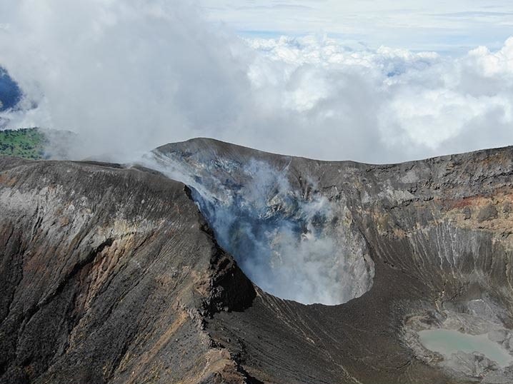
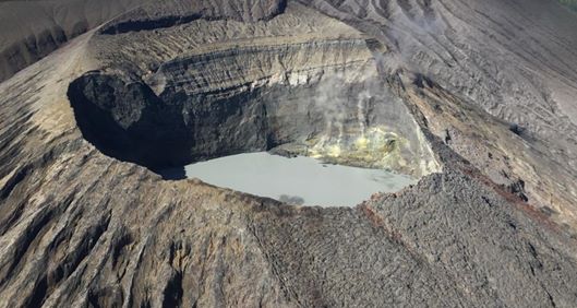
Irazu volcano
Lat: 9.979 ° N; Long: 83.852 ° W;
Altitude: 3432 m.s.n.m.
Current activity level: 1 (active)
Potentially associated hazards: landslides.
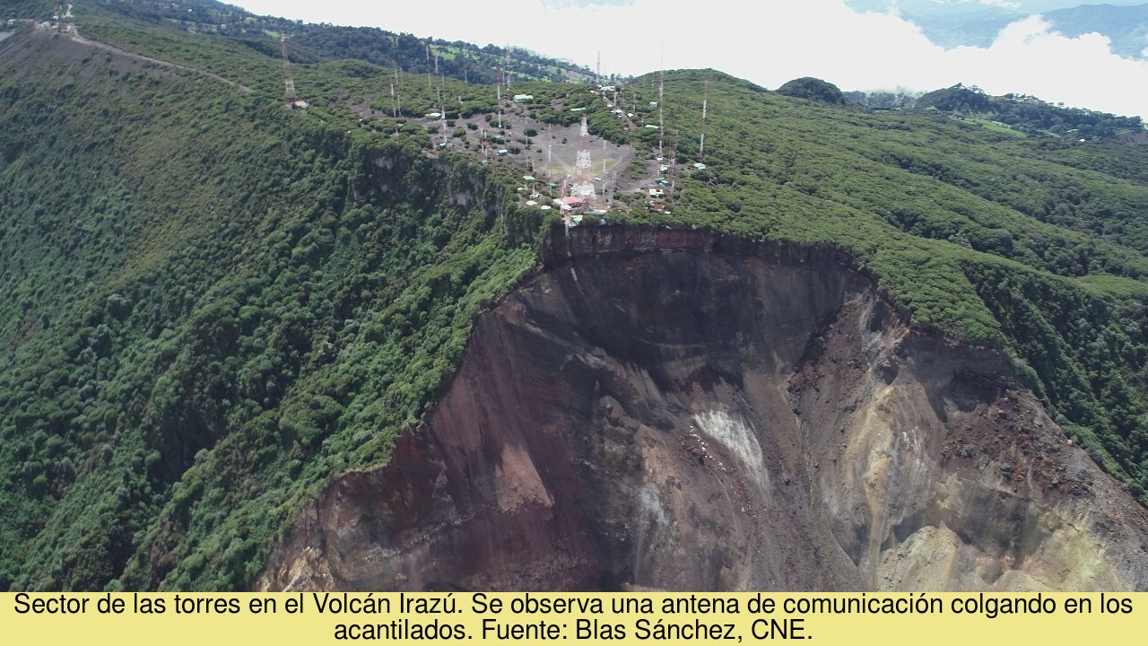
No seismic activity associated with the Irazú volcano was detected during the week. The concentration of CO2 on the northern flank of the volcano remains stable (weekly average of 509 + – 8 ppm). The main landslide in the western sector of the volcano continues with low horizontal and vertical speed. Photogrammetric drone flights made it possible to quantify in approx. 40,000 m3 is the volume of material that fell into the main crater from the western edge between February 2020 and February 2021. We could compare this volume of material with the size of the Buenaventura Corrales school in San José. (Metal building).
Source : Ovsicori .
Photos : G. Avard / Ovsicori , Jean Paul Calvo , Chris Allen / Sunquest Helitours , Blas Sanchez / CNE.