February 05 , 2021 .
Saint Vincent , Soufrière Saint Vincent :
LA SOUFRIÈRE BULLETIN , FEBRUARY 3, 2021 8:00 PM
The results of some of the tasks carried out during the trip to the summit of the La Soufriere Volcano on Monday 1st February 2021 are as follows:
Some gas measurements were done on Monday using a Multi-Gas Instrument and a filter pack. The Multi-Gas measurements were successful and showed the presence of Sulfur dioxide (SO2 gas coming out of the volcano. The filter packs used to measure gas species such as hydrogen chloride (HCl), Hydrogen fluoride (HF), Sulfur dioxide (SO2) and Hydrogen Sulfide (H2S) will need to be sent abroad for analyses.
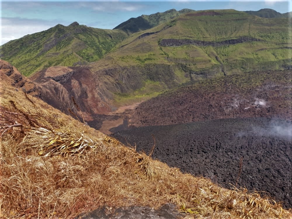
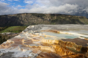
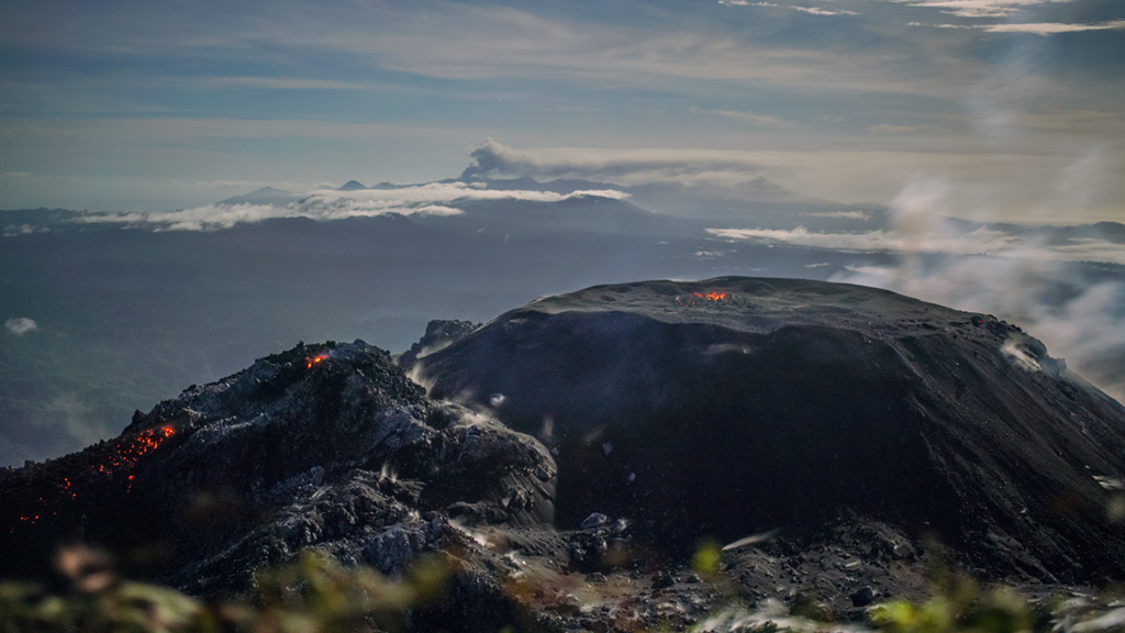
Latest view of the new dome. The dome is currently spreading laterally (sideways) along the crater floor.
Monday February 1, 2021 was the first day that Sulfur dioxide (SO2) gas was detected in the eruption.
The absence of Sulfur dioxide in the early stages of the eruption was due to the interaction of sulfur dioxide with the ground water (Sulfur dioxide was dissolving in the ground water.
The fact that Sulfur dioxide (SO2) gas is now coming out of the volcano suggests that the ground water is drying up.
The dome survey produced a volume of 5.93 million cubic meters
Observations made of the crater floor suggest that another fire occurred in the north western region of the crater (to the immediate north of the dome) which affected vegetation on vertical face of the crater.
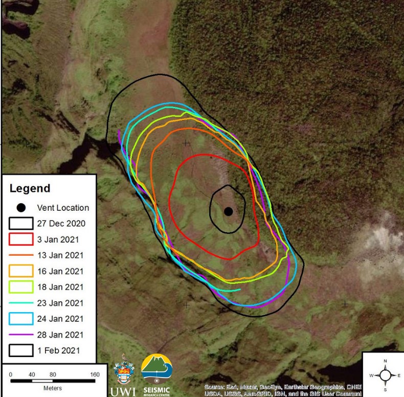
New lava dome footprint (surface area) derived from various sources including oblique photographs, aerial photogrammetry and satellite imagery.
Electronic Distance Measurement (EDM) target was hit from the Chateaubelair area using a total station on Monday while the team was on the summit. This is good news for the establishment of the EDM network on the western flank of the volcano. (The EDM Network is used to assist with measurements of deformation associated with the flanks of the volcano).
The National Emergency Management Organisation is reminding the public that no evacuation order or notice has been issued.
Source : Nemo .
Photos : UWI-SRC/MVO / Adam Stinton.
Kamchatka , Klyuchevskoy :
56.06 N, 160.64 E;
Elevation 4750 m (15580 ft)
Aviation Colour Code is ORANGE
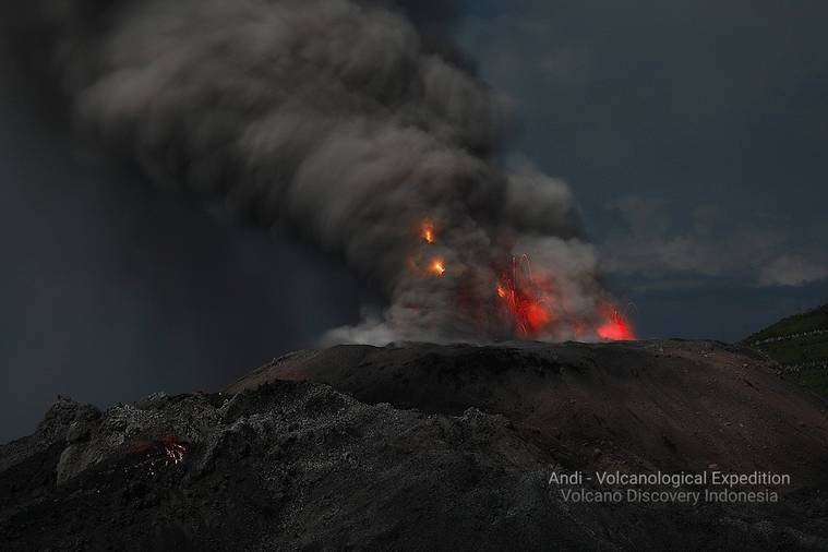
A moderate explosive-effusive eruption of the volcano continues. Ash explosions up to 9-10 km (29,500-32,800 ft) a.s.l. could occur at any time. Ongoing activity could affect international and low-flying aircraft.
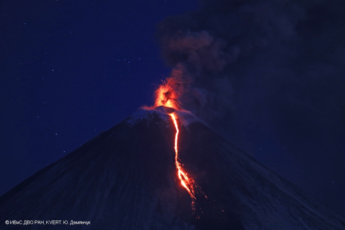
A moderate explosive-effusive eruption of the volcano continues, the Strombolian, gas-steam and sometimes Vulcanian activity is observing. The lava flow continues to move along Apakhonchichsky chute on the southeastern volcanic flank. Satellite data showed a large thermal anomaly in the area of the volcano all week; gas-steam plumes containing some amount of ash rose up to 6 km a.s.l., and extended for 92 km to the different directions of the volcano.
Source : Kvert
Photo : Yu Demyanchuk. IVS FEB RAS, KVERT
Indonesia , Ibu :
Level of activity at level II (WASPADA). Mount Api Ibu (1340 m above sea level) has been in continuous eruption since 2008. The eruption produced ash and blocks which accumulated in the crater. The last eruption took place on December 24, 2020, resulting in a column height of 800 m above the summit. The color of the ash column was white / gray.
The volcano was clearly visible until it was covered in fog. The smoke from the crater was observed to be white / gray with low intensity, medium to thick, about 200 to 800 meters above the summit. The weather is sunny to rainy, with light to moderate winds to the south and west.
According to the seismographs of February 4, 2021, it was recorded:
74 eruption / explosion earthquakes
138 avalanche earthquakes
37 emissions earthquakes
73 harmonic tremors
1 deep volcanic earthquake
1 local tectonic earthquake
4 distant tectonic earthquakes.
VOLCANO OBSERVATORY NOTICE FOR AVIATION – VONA.
Issued : February 04 , 2021
Volcano : Ibu (268030)
Current Aviation Colour Code : ORANGE
Previous Aviation Colour Code : orange
Source : Ibu Volcano Observatory
Notice Number : 2021IBU02
Volcano Location : N 01 deg 29 min 17 sec E 127 deg 37 min 48 sec
Area : North Maluku, Indonesia
Summit Elevation : 4240 FT (1325 M)
Volcanic Activity Summary :
Eruption with volcanic ash-cloud at 22h28 UTC (07h28 local)
Volcanic Cloud Height :
Best estimate of ash-cloud top is around 6800 FT (2125 M) above sea level, may be higher than what can be observed clearly. Source of height data: ground observer.
Other Volcanic Cloud Information :
Grey ash-cloud moving to west
Remarks :
Eruption and ash emission is continuing
Source : PVMBG, Magma Indonésie.
Photos : Martin Rietze . Andi Rosati / Volcanodiscovery.
Ecuador , Sangay :
DAILY REPORT OF THE STATE OF THE SANGAY VOLCANO, Friday 04 February 2021.
Surface activity level: High, Surface trend: Increasing.
Internal activity level: High, Internal trend: Increasing.
Seismicity: From February 03, 2021, 11:00 a.m. to February 04, 2021, 11:00 a.m .:
Long period type events (LP): 20
Explosions (EXP): 122
Emission tremor (TREMI): 2
Rains / lahars:
No rainy episodes were recorded in the area.
** In the event of heavy rains, they could re-mobilize the accumulated materials, generating mudslides and debris that would descend the sides of the volcano and flow into the adjacent rivers. **
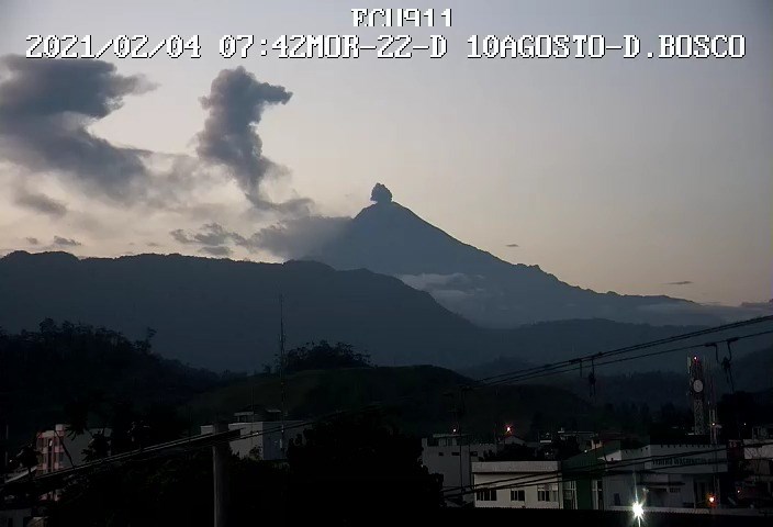
Emission / ash column: In the institute’s camera and on the images shared by the ECU911, several gas emissions were observed which reached heights of up to 1500 meters above the crater level, the direction of these emissions were oriented towards the southwest. The VAAC recorded 6 ash emission alerts observed by satellites at altitudes between 900 and 1800 meters above the crater level in the West, South-West and South directions.
Other monitoring parameters: FIRMS reported 15 thermal alerts on the Sangay in the last 24 hours.
MIROVA reported 1 low thermal alert on the Sangay in the last 24 hours.
Observations: On the images shared by the ECU911, the emissions described above were observed. The rest of the time the volcano was cloudy. There is no report of ash fall.
Alert level: yellow.
Sources : INSTITUT GÉOPHYSIQUE / ÉCOLE NATIONALE DE POLYTECHNIQUE.
Photo : igepn.
Guatemala , Pacaya :
Weather conditions: Clear weather
Wind: north
Precipitation: 0.0 mm.
Activity:
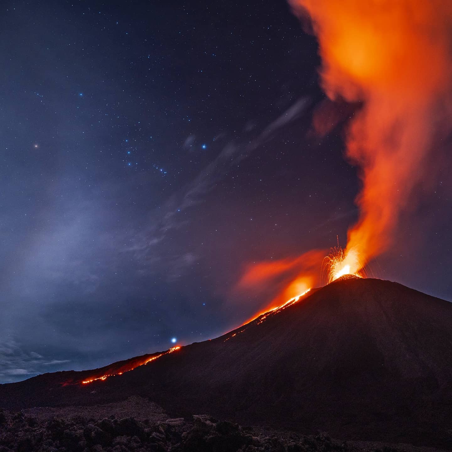
Strombolian type explosions are recorded, mostly weak to moderate, which expel incandescent materials up to a height of 225 meters above the crater. Simultaneously, periods of continuous incandescence with white and blue degassing come out of the crater, which disperses over several kilometers to the south. Ashes are projected at an altitude of 100 to 300 meters above the Mackenney crater and scatter southwards. Lava flow activity continues on the southern flank. The length of the lava flow is about 900 meters. INSIVUMEH seismic stations constantly record tremors, associated with the rise of magma, as well as the continuous degassing observed in the crater. The appearance of more lava flows on other flanks or the generation of degassing columns with abundant ash is not excluded, the recommendations of the special BEPAC bulletin n ° 003-2021 therefore remain in force.
Source : Insivumeh .
Photo : Diego Rizzo via Sherine France.