December 07 , 2020.
La Réunion , Piton de la Fournaise :
Activity bulletin from Monday December 7 at 03:00 (local time)
Alert level: Alert 1
Since 02:28 local time, a new seismic crisis has been recorded on the instruments of the Volcanological Observatory of Piton de la Fournaise. This seismic crisis is accompanied by rapid deformation.
This indicates that the magma is leaving the magma reservoir and is spreading towards the surface. An eruption is likely shortly within the next few minutes or hours.
Additional information will follow concerning the sector impacted by this magmatic propagation towards the surface.
Activity bulletin from Monday December 7 at 05:00 (local time)
Recommended alert level: Alert 2-2
Following the seismic crisis which began at 02:28 local time today, the volcanic tremor synonymous with the arrival of magma near the surface has been recorded since approximately 04:40 local time.
Analysis of the data and observations from our cameras show that the eruptive fissure (s) opened on the western flank of the volcano and that the first lava poured out around 4:55 am to 5:00 am local time.
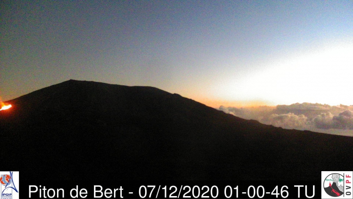
Figure 1: Shot of the eruption site from the OVPF Piton de Bert camera at 5:00 a.m. (local time, 1:00 a.m. UT).
Eruption in progress.
Activity bulletin from Monday December 7 at 09:15 (local time)
Alert level: Alert 2-2
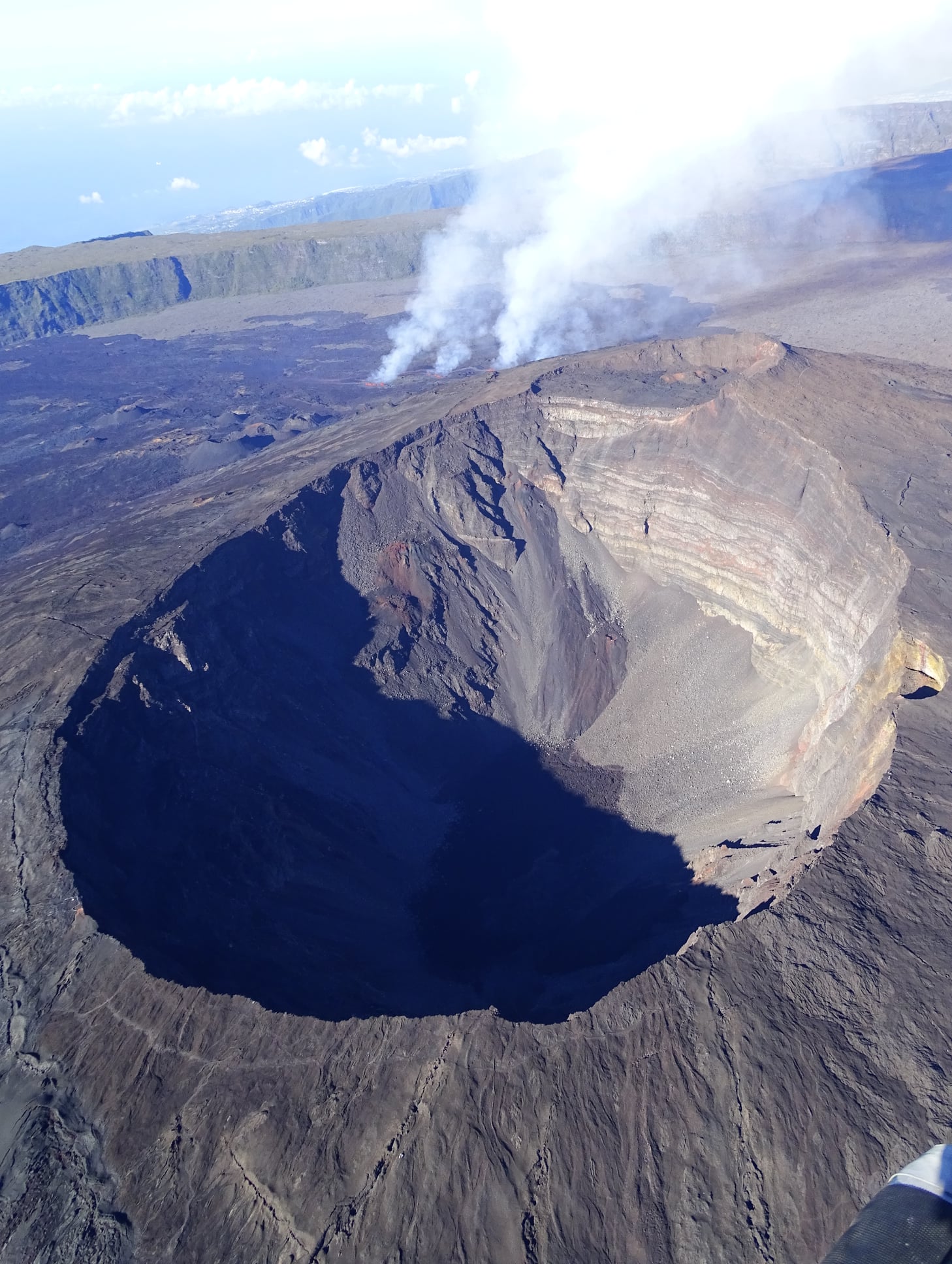
The eruption that started on 12/07/2020 around 4:40 am (appearance of the volcanic tremor) continues. Following an overview of the eruptive site carried out with the assistance of SAG and PGHM, the cracks could be precisely located (Figure 1).
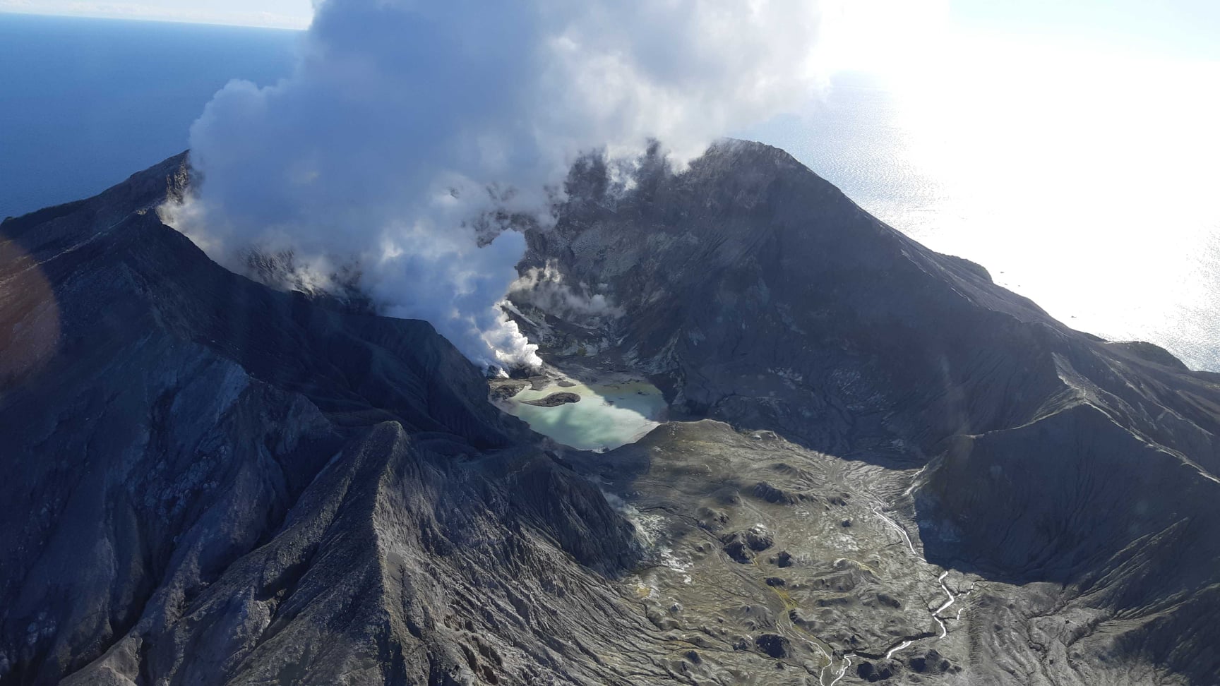
Three fissures opened on the west southwest flank of the volcano, at an altitude of between 2300 and 2190 m and a total distance of about 700 m.
During the overflight, between 7 a.m. and 7:30 a.m. local time, the three cracks were active, throwing lava fountains about fifteen meters high (Figure 2). The flow front was propagating very slowly and was located at an altitude of approximately 2120 meters (Figure 1).
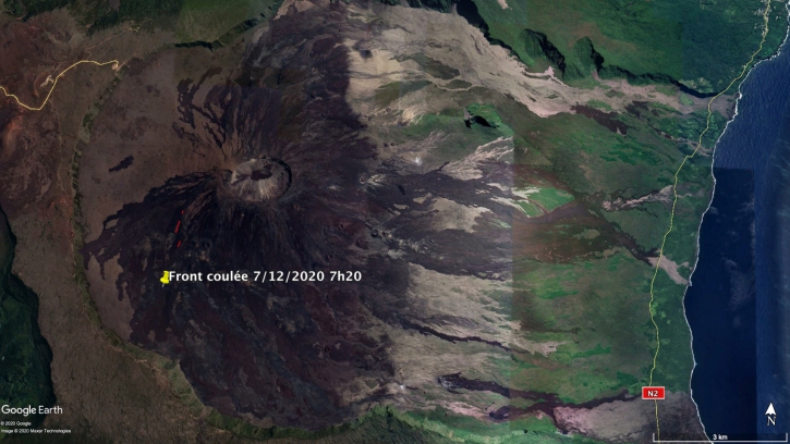
Figure 1: Mapping of eruptive cracks (in red) which opened on 12/7/2020 and location of the flow front at 7:30 am (local time; in yellow) © OVPF / IPGP.
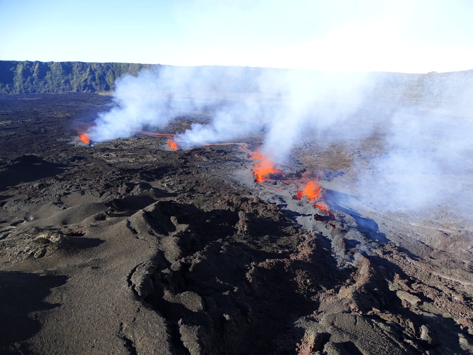
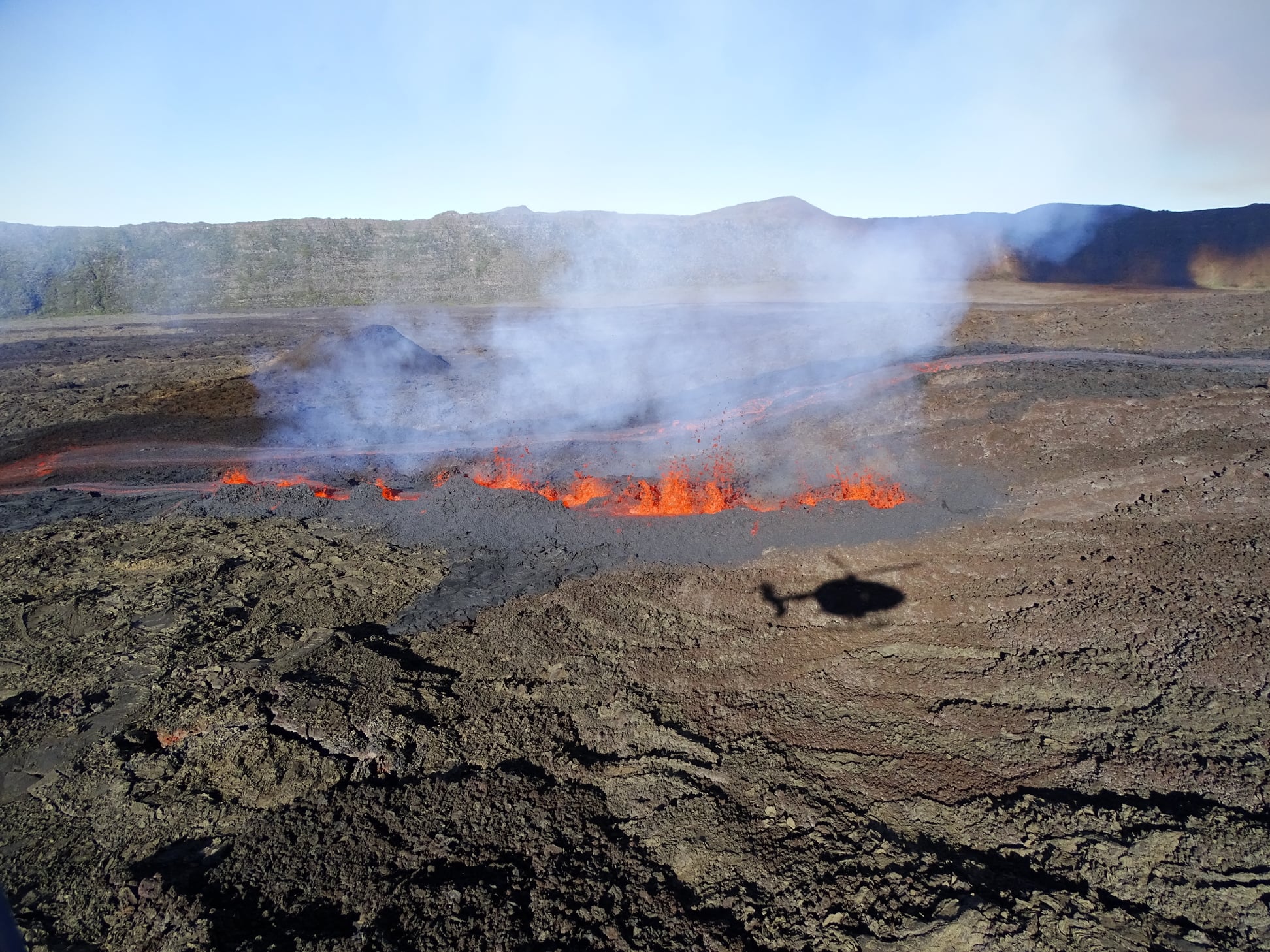
Figures 2: shots of the eruptive site at 7:30 a.m. (local time) on 12/7/2020 © OVPF / IPGP.
Source : OVPF.
Read the article : http://www.ipgp.fr/fr/ovpf/bulletin-dactivite-lundi-7-decembre-a-0300-heure-locale
Photos : OVPF
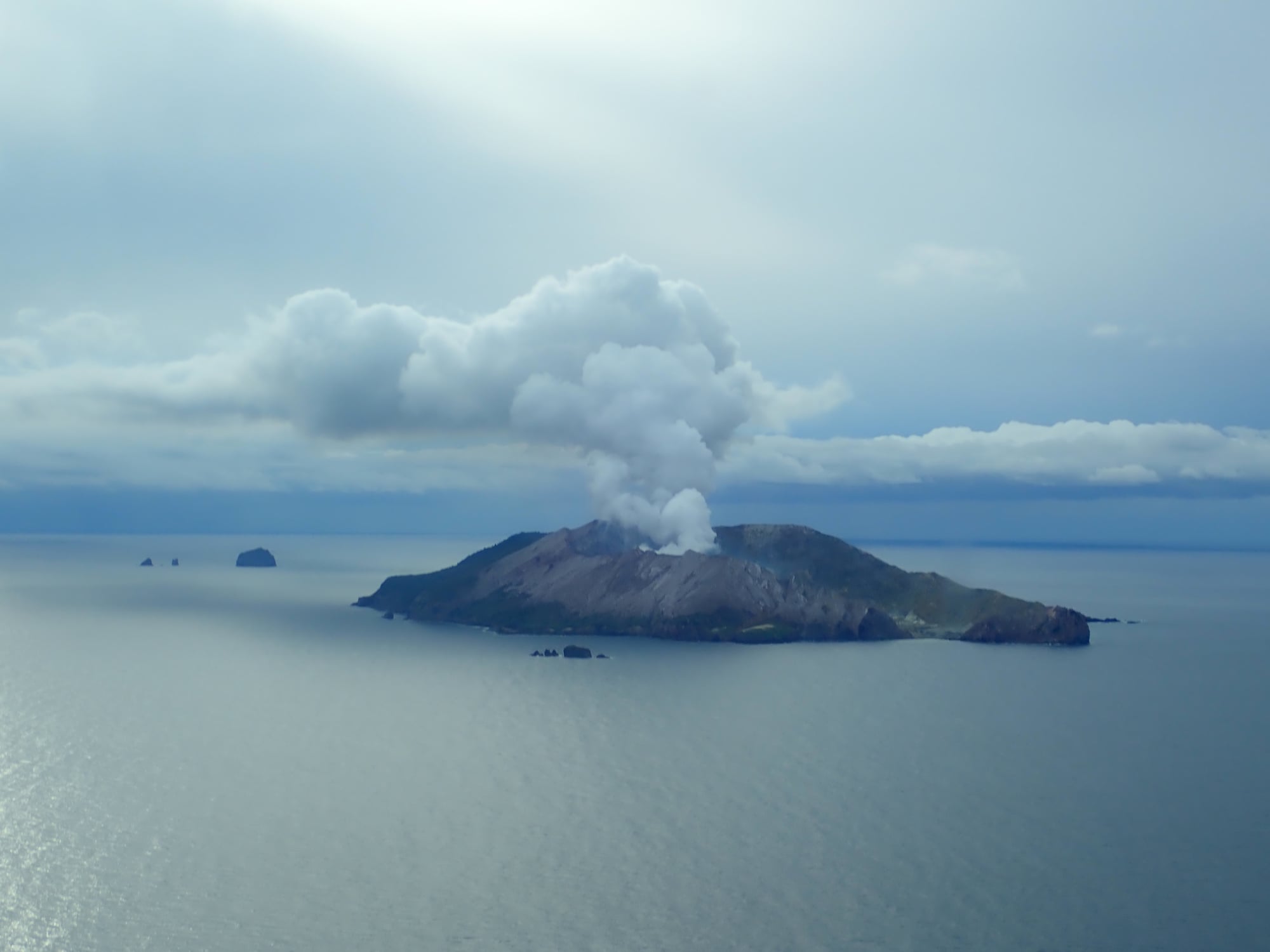
New Zealand , White Island :
Ash emission has stopped at Whakaari/White Island. Volcanic Alert Level is lowered to Level 1. Published: Mon Dec 7 2020 2:30 AM
Volcanic Alert Level is lowered to 1
Aviation Colour Code is lowered to Green
Observations in the last week show that ash is no longer being emitted from Whakaari. Levels of gas emission have also decreased, and other monitoring indicators remain low. The Volcanic Alert Level is lowered to Level 1.
Observations and monitoring data over the last 2 weeks indicate that Whakaari/White Island has been progressing on a gradual trend back to lower levels of volcanic unrest that are typical of the long-term behaviour of this volcano. An observation flight on 2nd December confirmed that ash emission from the volcano has now stopped. Satellite observations in the last week have also not detected any ash in the steam plume. Hot steam and gas emissions continue from the active vents.
A gas measuring flight on 2nd December showed that the main volcanic gases, Carbon dioxide (CO2) and Sulphur dioxide (SO2) have returned to lower levels, like those seen in September 2020. The level of volcanic seismic tremor and the number of local earthquakes remain low. Ground deformation data from satellite measurements indicate continued subsidence around the active vent area at the back of the crater lake as well as ongoing local subsidence of the Main Crater wall, south and west of the 2019 active vents.
These observations indicate that Whakaari/White Island is now back at a low level of unrest. The Volcanic Alert Level is lowered to Level 1 (from 2) and the Aviation Colour Code is lowered to Green (from Yellow).
Recent heavy rain has improved the camera views from the Factory camera, however other cameras remain affected by ash covering. All other monitoring instrumentation is currently operational.
The Volcanic Alert Level reflects the current level of volcanic unrest or activity and is not a forecast of future activity. Volcanic Alert Level 1 indicates the primary hazards are those expected during volcanic unrest; including discharge of steam and hot volcanic gases, earthquakes, landslides and hydrothermal activity. While Volcanic Alert Level 1 is mostly associated with environmental hazards, eruptions can still occur with little or no warning. The main plausible triggers for a sudden eruption remain the collapse of unstable material in an active vent and the possible ingress of water underground onto the shallow magma body.
GNS Science and our National Geohazards Monitoring Centre continuously monitor Whakaari/White Island for changes in activity. Further updates will be provided as needed.
Source : Geonet / Craig Miller / Volcanologue de service.
Photos : Geonet .
Read the article : https://www.geonet.org.nz/vabs/4MMUZ3YemGddtzbN8rAnXc
Nicaragua , Telica :
NICARAGUENSE INSTITUTE OF TERRITORIAL STUDIES (INETER)
VOLCANIC ACTIVITY REPORT OF DECEMBER 03, 2020
VOLCANO TELICA
The Telica volcano continues with gas emissions and the expulsion of ash, recording a total of 396 small explosions in the last 24 hours, for a total of 775 explosions since the start of this activity (Monday, November 30).
The ashes of these 24 hours reached heights of between 50 and 300 meters, above the level of the crater, most of which was deposited on the southwest side of the slopes of the volcano.
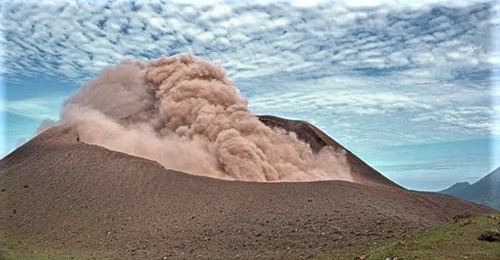
This type of activity is called « low energy volcanic activity », which is normal for an active volcano.
A thin layer of ash has fallen in the communities: Zarandaj, Cristo Rey, Las Colinas, Garrobo Empinado, El Panal, Canta Rana, Ceibo Chachagua, Las Mercedes, Punta Arena, La Virgen, Filiberto Morales.
Source et photo : Ineter .
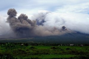
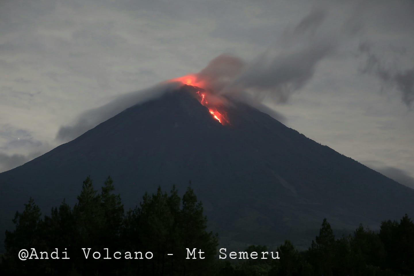
Indonesia , Semeru :
Level of activity at level II (WASPADA). G. Semeru (3,676 m above sea level) is continuously erupting. There are explosive and effusive eruptions, causing lava flows towards the southern and southeastern slopes, as well as explosions which project incandescent rocks around the summit crater.
The volcano was clearly visible until it was covered in fog. A thin white smoke from the crater was observed, 50-100 meters above the summit. There was a lava avalanche with a sliding distance of 200 to 750 meters towards Besuk Kobokan. An incandescence was observed at a height of 50 to 100 meters above the summit. The weather is sunny to rainy, with light to moderate winds in the North, North-East, East, South and South-West. Air temperature 22-26 ° C.
According to the seismographs of December 6, 2020, it was recorded:
6 eruption / explosion earthquake
26 avalanche earthquake
3 emission earthquakes
8 Harmonic tremors
1 deep volcanic earthquake
3 distant tectonic earthquakes
1 lahar signal
Recommendation:
In Level II (Waspada) status, people / visitors / tourists must not have activities within a radius of 1 km around the crater / summit of Mt Semeru and a distance of 4 km in the direction of opening of the crater in the South-South-East sector, as well as to be sensitized to the current of hot avalanche clouds, lava avalanches and lahars along the river / valley which originates at the top of the Mount Semeru. The recommended radius and distance will be continuously evaluated in anticipation of any change in hazard symptoms.
People should stay away from the hot cloud affected area because the temperature is still high.
Be careful of potential slips along the valley of the hot cloud path of Besuk Kobokan.
VONA: The latest VONA message received the color code ORANGE, published on December 5, 2020 at 23:28:00 WIB. Volcanic ash was observed at an altitude of 4676 m above sea level or about 1000 m above the summit.
Source : PVMBG.
Photo : Andi Volcanist