July 07 , 2024.
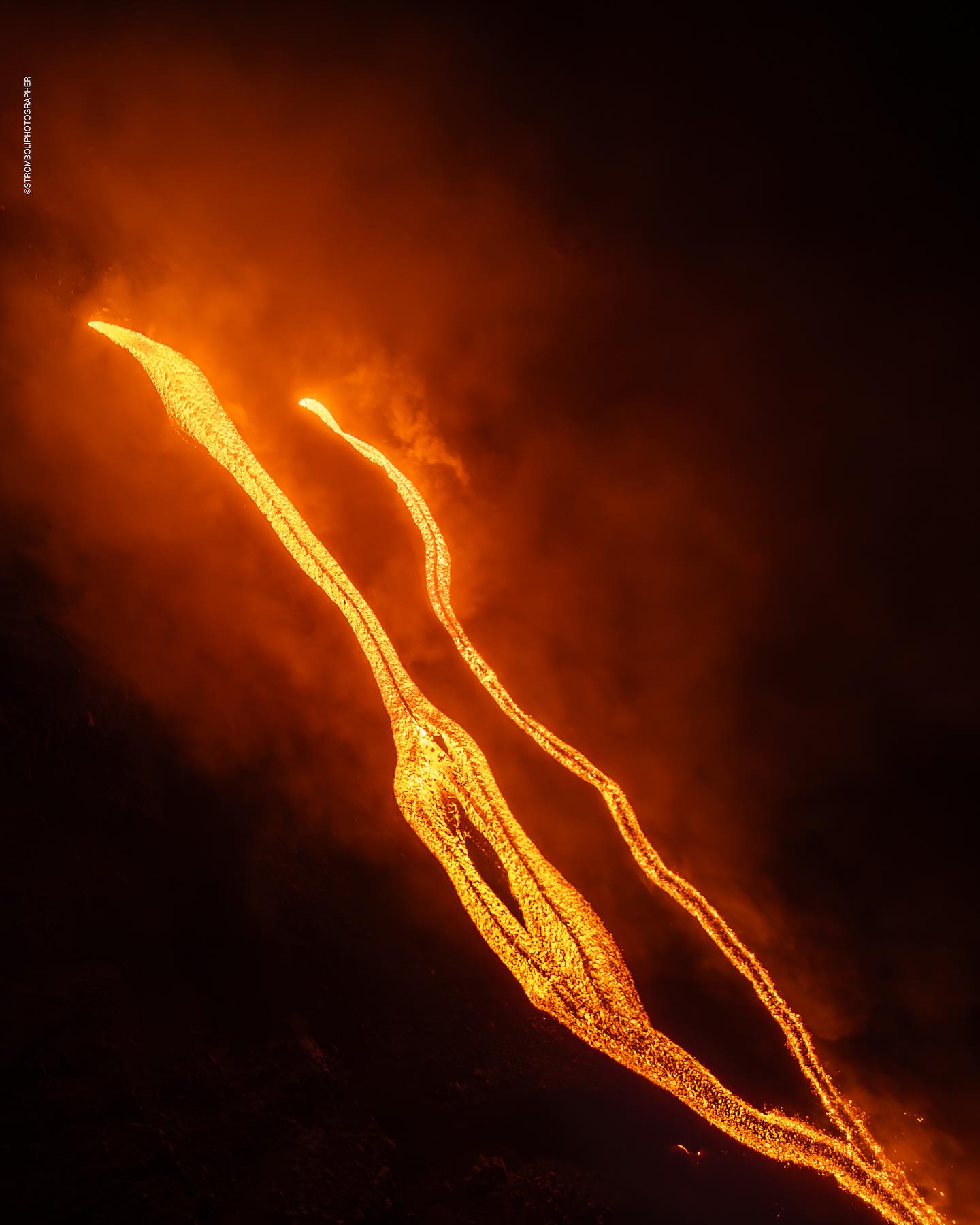
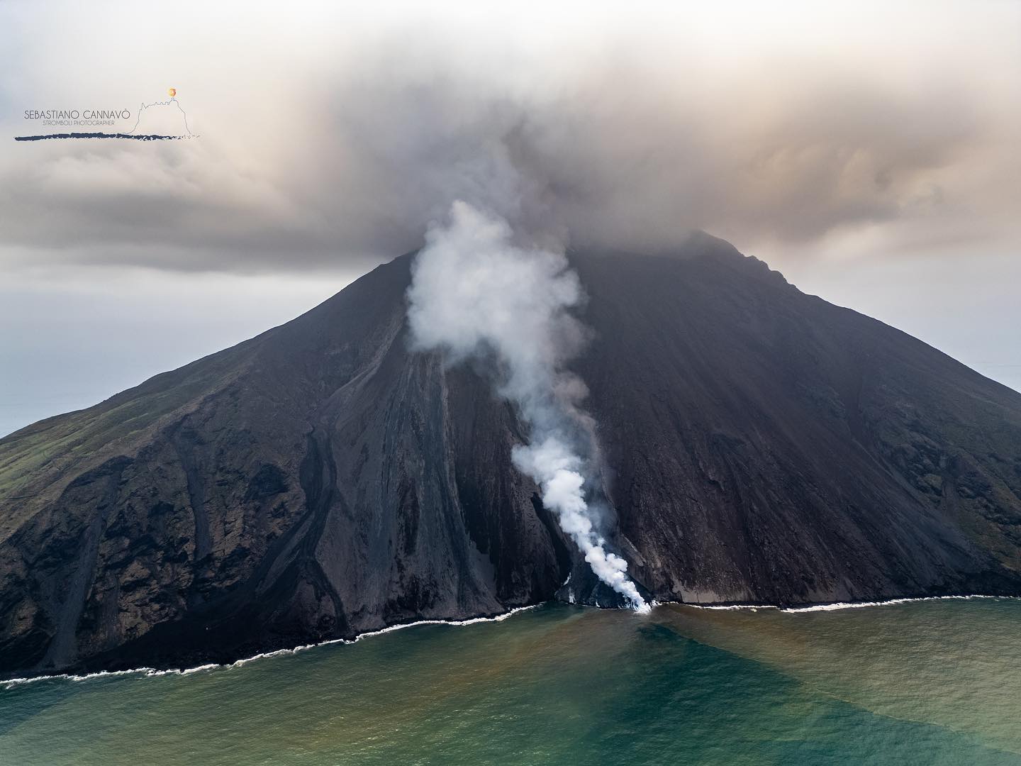
Italy , Stromboli :
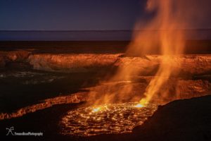
Press release on Stromboli activity, July 6, 2024, 11:59 (09:59 UTC).
The National Institute of Geophysics and Volcanology, Osservatorio Etneo, communicates that from the analysis of images from the cameras of the monitoring network and INGV personnel in the field, it is possible to observe that the flow on the Sciara del Fuoco generated by the outpouring the activity recorded yesterday at 6:55 p.m. UTC stopped a few dozen meters from the coast without reaching the sea.
There are currently no active flows. The average amplitude of the seismic signal, after what was reported in previous releases, continued to show a stability of values which are at a low level with peaks on the average values.
Analysis of seismograms continues to highlight a low level of activity, no evidence of explosion earthquakes and continued episodes of rock rolling.
The analysis of ground deformations highlights oscillations of approximately 0.4 microradians at the Timpone del Fuoco inclinometer station during the day. No significant changes to GNSS network stations.
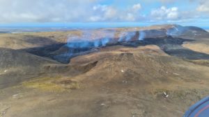
Press release on Stromboli activity, July 6, 2024, 1:21 p.m. (11:21 UTC).
The National Institute of Geophysics and Volcanology, Osservatorio Etneo, communicates that INGV staff on the ground observed that effusive activity has resumed from the vent previously located at 510 m altitude on the Sciara del Fuoco. The altitude of the mouth has currently fallen to 485 m above sea level and the flow front is located at around 200 m above sea level. We observe the detachment of blocks from the lava front which, rolling towards the coast, reach the sea.
The average amplitude of the seismic signal continues to show stability of values which are at a low level with peaks at the average values. Analysis of seismograms continues to highlight a low level of activity, no evidence of explosion earthquakes and continued episodes of rock rolling.
No updates or significant changes to the analysis of ground deformation monitoring networks.
Further updates will be communicated shortly.
Source : INGV
Photos : Stromboli stati d’animo / Sebastiano Cannavo.
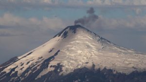
Italy / Sicily , Etna :
Press release on the activity of Etna, July 7, 2024, 02:36 (00:36 UTC).
The National Institute of Geophysics and Volcanology, Osservatorio Etneo, communicates that according to the analysis of images from surveillance cameras, a progressive increase in Strombolian activity in the Voragine crater was observed from 10 p.m. UTC approximately, which resumed in the afternoon of yesterday July 6. The forecast model for the dispersion of the possible eruptive cloud indicates an East-South-East direction.

The average amplitude of the volcanic tremor from 22:30 UTC presents a rapid increase that reached high values around 23:20 UTC, where it still remains with an increasing trend. The center of gravity of the volcanic tremor sources is located in the east of Voragine, at an altitude of approximately 2,800 m above sea level. Infrasound events recorded an increase in activity from 22:30 UTC, characterized by infrasound events and tremors located at the level of the Voragine crater.
The amplitude of events is average with an increasing trend.
The analysis of ground deformation data does not highlight significant variations at the GNSS, inclinometer and dilatometric network stations, with the exception of a weak transient in compression of 3 nano-strain at the Monte Ruvolo dilatometer (DRUV ) and less than 0.1 microradians from the Piano Crater Inclinometer (ECP) between 1:30 p.m. UTC and 2:00 p.m. UTC on July 6.
Press release on the activity of Etna, July 7, 2024, 04:28 (02:28 UTC).
The National Institute of Geophysics and Volcanology, Osservatorio Etneo, communicates that according to the analysis of images from the surveillance camera network, it is possible to observe that the Strombolian activity in the Voragine crater has further intensified and a lava fountain is currently underway. This activity produces ash emissions which, in accordance with the forecast model, disperse in the East-South-East direction.
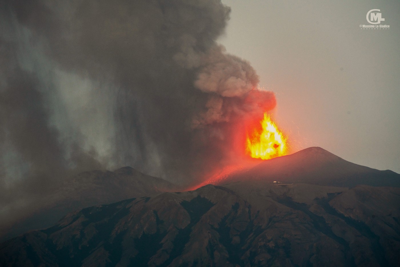
The average amplitude of the volcanic tremor continues to present an increase in values and has currently reached a very high level. The center of gravity of the sources of volcanic tremors is located in the East of Voragine, at an altitude of about 2,800 m above sea level. There is a further increase in the frequency of occurrence and of the amplitude of infrasound events located in the Voragine crater. The amplitude of the infrasound tremor increases.
Ground deformation networks begin to show variations from 01:00 UTC. In particular, a deformation begins which, for the moment, reaches a little more than 0.1 microradians at the ECP summit inclinometer and around 5 nano-deformation in decompression at the DRUV dilatometer. The GNSS network shows no variation apart from background noise.
Further updates will be communicated shortly
Source : INGV
Photos : Massimo Lo Giudice via FB.
Russia / Kuril Islands , Ebeko :
VOLCANO OBSERVATORY NOTICE FOR AVIATION (VONA)
Issued: July 07 , 2024
Volcano: Ebeko (CAVW #290380)
Current aviation colour code: ORANGE
Previous aviation colour code: orange
Source: KVERT
Notice Number: 2024-37
Volcano Location: N 50 deg 41 min E 156 deg 0 min
Area: Northern Kuriles, Russia
Summit Elevation: 1156 m (3791.68 ft)
Volcanic Activity Summary:
A moderate explosive eruption of the volcano continues. According to visual data from Severo-Kurilsk, an explosion sent ash up to 2 km a.s.l., and ash cloud drifted to the north of the volcano.
A moderate explosive eruption of the volcano continues. Ash explosions up to 6 km (19,700 ft) a.s.l. could occur at any time. Ongoing activity could affect low-flying aircraft and airport of Severo-Kurilsk.
Volcanic cloud height:
2000 m (6560 ft) AMSL Time and method of ash plume/cloud height determination: 20240707/0215Z – Visual data
Other volcanic cloud information:
Distance of ash plume/cloud of the volcano: 5 km (3 mi)
Direction of drift of ash plume/cloud of the volcano: N
Time and method of ash plume/cloud determination: 20240707/0230Z – Visual data
Source : Kvert
Photo : Yuri Demyanchuk. (archive).
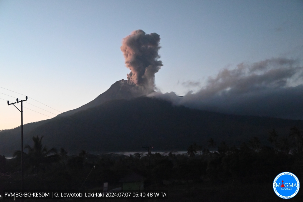
Indonesia , Lewotobi Laki-laki :
An eruption of Lewotobi Laki-laki occurred on Sunday July 7, 2024 at 05:37 WITA with an ash column height observed at ± 300 m above the summit (± 1884 m above sea level). The ash column was observed to be gray with thick intensity, oriented towards the South-West and West. This eruption was recorded on a seismograph with a maximum amplitude of 10.5 mm and a duration of 173 seconds.
VOLCANO OBSERVATORY NOTICE FOR AVIATION – VONA
Issued : July 06 , 2024
Volcano : Lewotobi Laki-laki (264180)
Current Aviation Colour Code : ORANGE
Previous Aviation Colour Code : orange
Source : Lewotobi Laki-laki Volcano Observatory
Notice Number : 2024LWK180
Volcano Location : S 08 deg 32 min 20 sec E 122 deg 46 min 06 sec
Area : East Nusa Tenggara, Indonesia
Summit Elevation : 5069 FT (1584 M)
Volcanic Activity Summary :
Eruption with volcanic ash cloud at 21h37 UTC (05h37 local).
Volcanic Cloud Height :
Best estimate of ash-cloud top is around 6029 FT (1884 M) above sea level or 960 FT (300 M) above summit. May be higher than what can be observed clearly. Source of height data: ground observer.
Other Volcanic Cloud Information :
Ash cloud moving from southwest to west. Volcanic ash is observed to be gray. The intensity of volcanic ash is observed to be thick.
Remarks :
Eruption recorded on seismogram with maximum amplitude 10.5 mm and maximum duration 173 second.
Source et photo : Magma Indonésie.
Hawaii , Kilauea :
Saturday, July 6, 2024, 8:27 AM HST (Saturday, July 6, 2024, 18:27 UTC)
19°25’16 » N 155°17’13 » W,
Summit Elevation 4091 ft (1247 m)
Current Volcano Alert Level: ADVISORY
Current Aviation Color Code: YELLOW
Activity Summary:
Kīlauea volcano is not erupting. Earthquake counts in the upper East Rift Zone remain above background levels following the seismic swarm that took place from June 27–July 1. Longer-term, gradual inflation of the summit and upper rift zones has persisted since the end of the June 3, 2024, eruption. Any substantial increases in seismicity and/or deformation could result in a new eruptive episode, but there are no signs of an imminent eruption at this time.
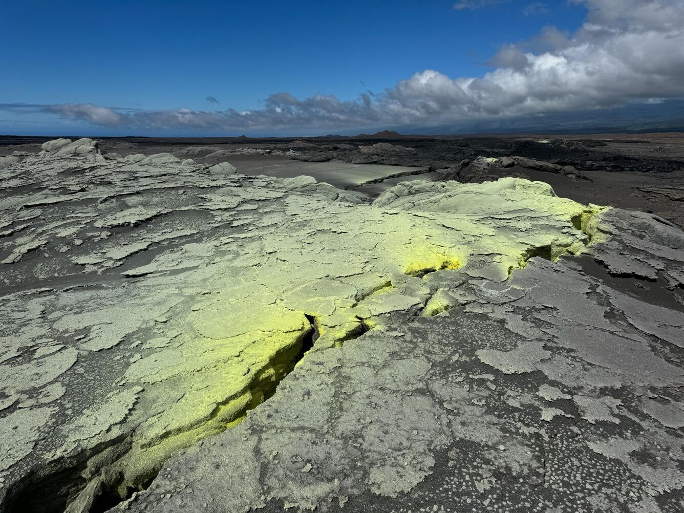
While HVO geologists were moving temporary webcams, they revisited the site of the June 3 eruption. This photo looks downrift, with the June 3 pad of lava in the upper right. Extensive cracking uprift of the fissure had weak residual outgassing and vibrant sulfur deposits.
Summit and Upper Rift Zone Observations:
Over the past 24 hours, there were approximately 12 earthquakes detected beneath Kaluapele (Kīlauea caldera) and 20 earthquakes detected beneath the upper East Rift Zone, mostly at depths of 1–3 km (0.6–1.8 mi) beneath the ground surface. These counts are similar to the past couple of days, and similar to daily counts recorded prior to the June 27–July 1 swarm. In the past day, the SDH instrument southwest of the summit recorded approximately 4 microradians of inflationary tilt. The UWE instrument northwest of the summit was serviced on July 2, and data qualitatively show minor inflationary tilt over the past 24 hours (about a microradian – see the monitoring notice below). GPS instruments around the summit region continue to show longer-term, gradual inflation since the end of the June 3, 2024, eruption. The most recent measurement of the summit’s SO2 emission rate was approximately 75 tonnes per day on June 28, 2024.
Middle and Lower Rift Zone Observations:
Rates of seismicity and ground deformation beneath the middle and lower East Rift Zone and lower Southwest Rift Zone remain low. Recent eruptive activity and ongoing unrest have been restricted to the summit and upper rift zone regions. Measurements from continuous gas monitoring stations downwind of Puʻuʻōʻō in the middle East Rift Zone—the site of 1983–2018 eruptive activity—remain below detection limits for SO2, indicating that SO2 emissions from Puʻuʻōʻō are negligible.
Source : HVO
Photo : USGS / M. Patrick.