October 21 , 2020.
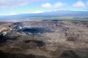
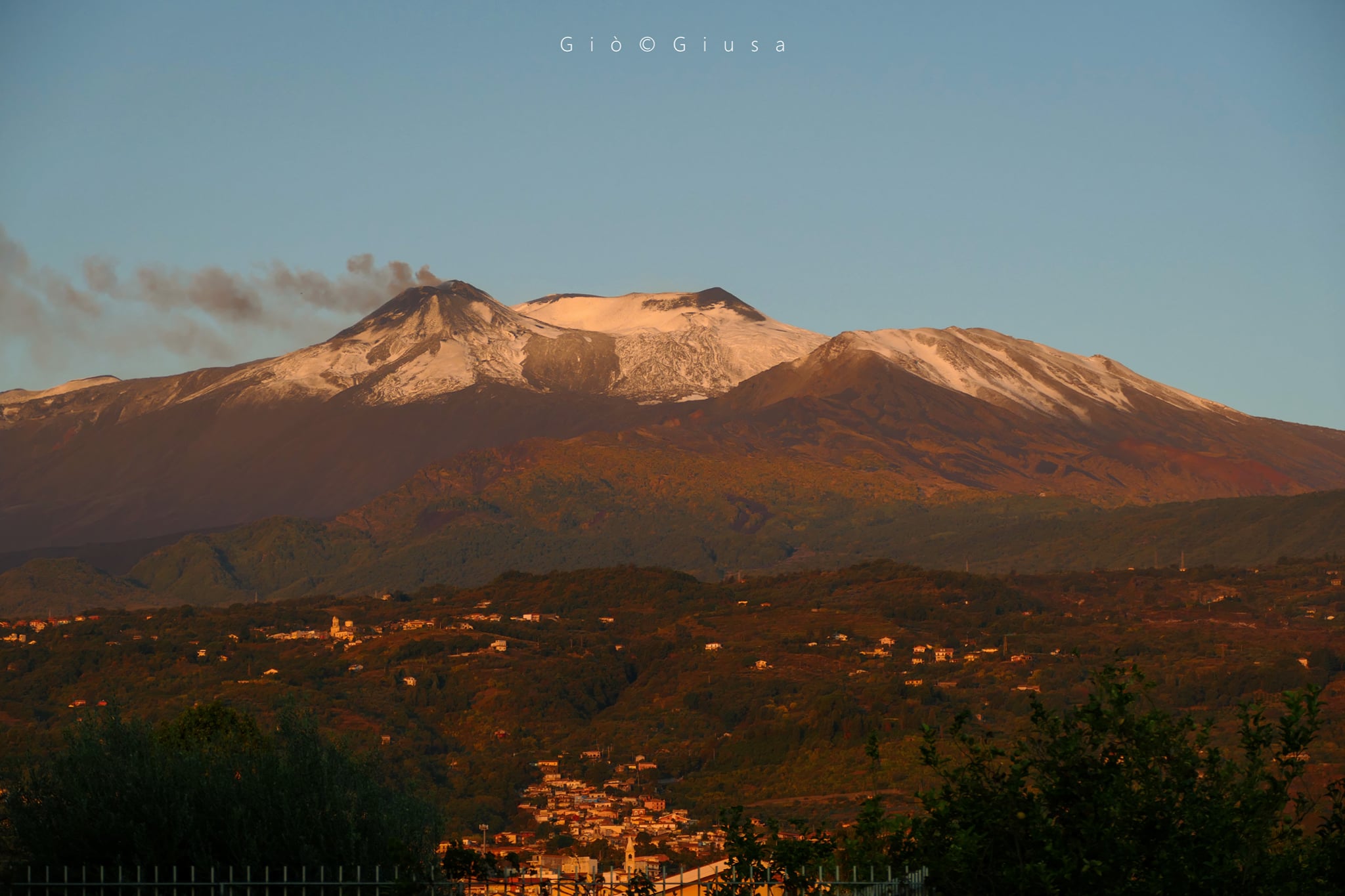
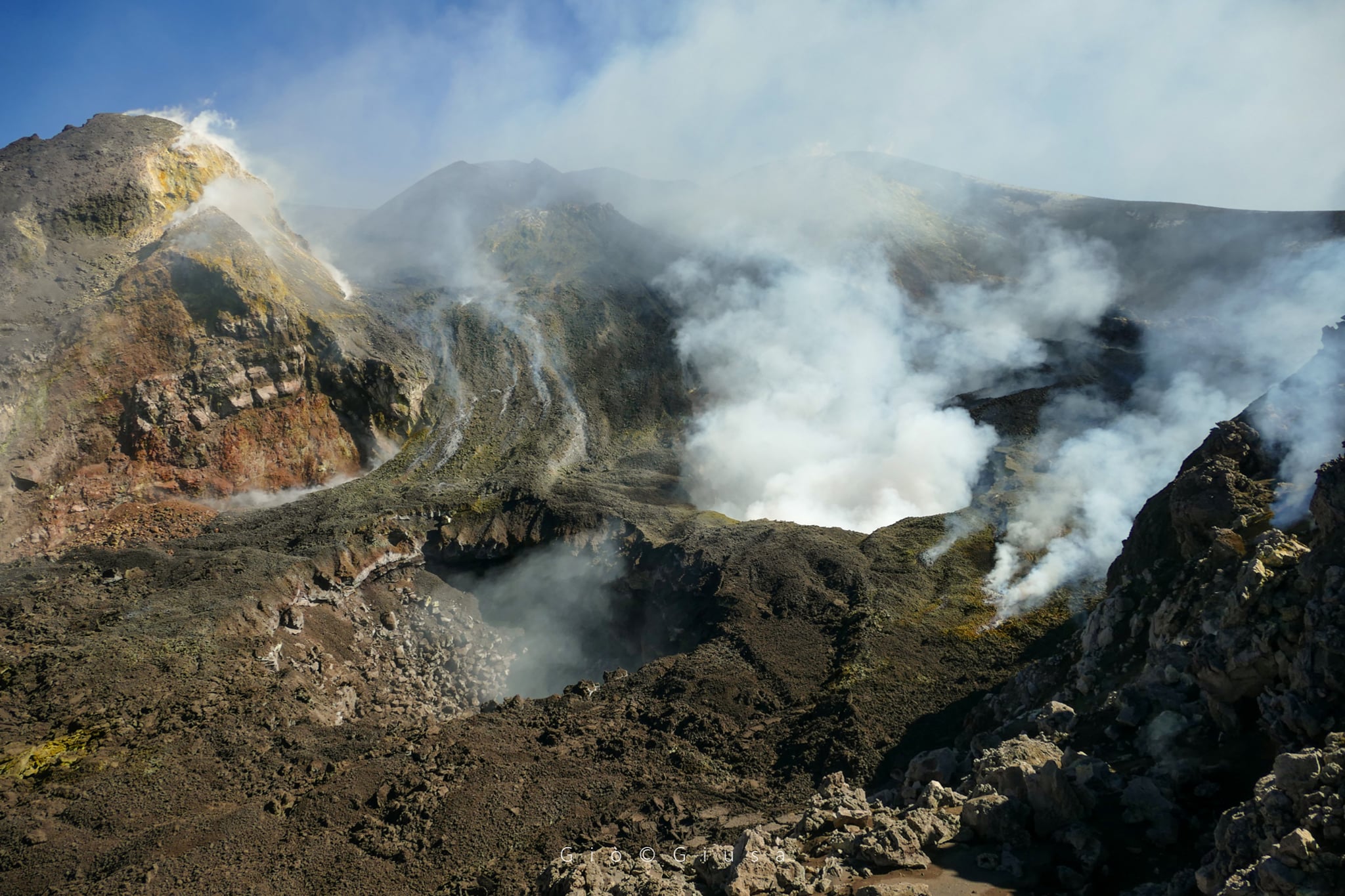
Italy / Sicily , Etna :
Weekly Bulletin, October 12, 2020 – October 18, 2020
(issue date 20 October 2020)
SUMMARY OF THE STATE OF ACTIVITY
In the light of surveillance data, it is highlighted:
1) VOLCANOLOGICAL OBSERVATIONS: Variable strombolian activity with emission of ash at the New Southeast Crater; Strombolian activity within the deep crater at the northeast crater; degassing activity of the craters of Voragine and Bocca Nuova.
2) SEISMOLOGY: low seismic activity of fracturing; stationarity of the parameters of the volcanic tremor mainly on the average values.
3) INFRASOUND: Modest infrasound activity.
4) DEFORMATIONS: The Etna soil deformation monitoring networks have not shown significant changes over the past week
5) GEOCHEMISTRY: The flow of SO2 occurs at a medium-low level.
HCl flow occurs at an average level.
6) SATELLITE OBSERVATIONS: The thermal activity in the summit area is at a low level.
VOLCANOLOGICAL OBSERVATIONS
The monitoring of the volcanic activity of Etna, during the week in question, was carried out by analyzing the images of the network of surveillance cameras of the INGV, Osservatorio Etneo (INGV-OE), and through various observations made by INGV-OE staff. Bad weather conditions have repeatedly limited the observation of eruptive phenomena.
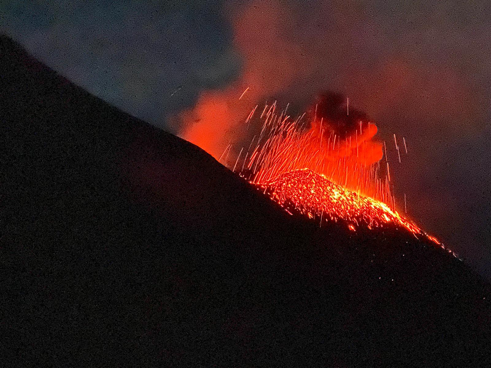
During the week under review, the activity of the summit craters of Etna continued in a manner similar to what had been observed in the previous weeks. This activity consisted of episodic Strombolian activity with periodic ash emissions at the New Southeast Crater (NSEC), deep intracrater Strombolian activity at the Northeast Crater (NEC) and degassing at the Voragine craters ( VOR) and Bocca Nuova (BN).
In particular, the “saddle cone” of the New Southeast Crater continued its episodic Strombolian activity, sometimes accompanied by modest emissions of ash. This activity has continued since mid-July without significant changes. During the phases of more intense activity, the pyroclastic products launched from the mouth fell on the external faces of the cone.
The intracrater Strombolian activity of the various vents at the bottom of the Northeast crater continues, without significant changes. Some nights, the gleams of the North-East crater were visible on the images of the surveillance cameras of the INGV-OE.
At the level of the Voragine and Bocca Nuova craters, activity was limited to degassing.
Volcanic tremor:
The temporal trend of the mean amplitude of the volcanic tremor showed large fluctuations, mainly at an average level, throughout the week and rarely such fluctuations reached a high level. The source of the tremor was constantly located in the New Southeast Crater (NSEC) area, at a depth of about 2900-3000 meters above mean sea level
Source : INGV.
Photos : Gio Giusa.
Italy , Stromboli :
Weekly Bulletin, October 12, 2020 – October 18, 2020
(issue date 20 October 2020)
SUMMARY OF THE STATE OF ACTIVITY:
In the light of surveillance data, it is highlighted:
1) VOLCANOLOGICAL OBSERVATIONS: Normal explosive volcanic activity of Strombolian type at low and medium-low levels (4-10 events / h) and with a medium-low intensity in the North zone and medium-high in the Center-South zone.
2) SEISMOLOGY: The seismological parameters do not show significant variations.
4) DEFORMATIONS: The island’s soil deformation monitoring networks did not show any significant changes to report for the period under review.
5) GEOCHEMISTRY: Medium-low SO2 flux.
6) SATELLITE OBSERVATIONS: The thermal activity in the summit area is at a low level.
Stromboli at nightfall on September 2, 2020, activity seen by the northern ridge of the Sciara del Fuoco at about 700 m. The photos were taken by Alessandro Gattuso (INGV-Palermo).
VOLCANOLOGICAL OBSERVATIONS
In the period under observation, the eruptive activity of Stromboli was characterized by the analysis of the images recorded by the surveillance cameras of the INGV-OE located at an altitude of 190 m, in Punta dei Corvi and at 400 m from ‘altitude.
In the area of the North crater, the N1 crater, with three emission points, produced explosions of low intensity (less than 80 m high) to medium (less than 150 m high) emitting coarse materials (lapilli and bombs) sometimes mixed fine materials (ash). Vent N2, with two emission points, showed mainly low to medium intensity explosive activity, emitting coarse material mixed with fine material. The average frequency of the explosions varied from 3 to 9 events / h.
In the Center-South zone, the explosions mainly emitted fine materials sometimes mixed with coarse materials with a medium-high intensity (the products emitted often exceeded 250 m in height).
The low explosive activity showed a maximum frequency of 1 event / h.
The amplitude of the volcanic tremor had generally low values, with some oscillations on medium-low values.
Source : INGV.
Photo : Alessandro Gattuso (INGV-Palerme).
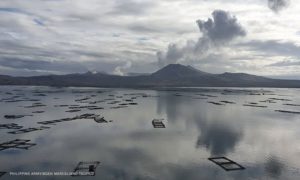
Iceland , Reykjanes Peninsula :
M5.6 at the Reykjanes peninsula , The largest earthquake measured since 2003, October 20 , 2020.
At 13:43 today (20th of October) an earthquake of M5.6 occurred in Núpshlíðarháls, about 5 km west of the geothermal area in Seltún on the Reykjanes peninsula. The earthquake was felt widely around the country, especially the southern part of the Reykjanes peninsula and in the capital area, which is some 25 km from the epicenter. At this time over 250 aftershocks have been detected, the largest ones in the period between 15:27 and 15:32. The largest was of M4.1, other earthquakes between 3.0 and 3.8. There are no signs of volcanic unrest in the area.
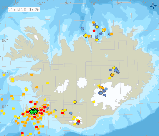
The earthquake today is the largest earthquake measured in the Reykjanes peninsula since 2003.
“There is an active long-term process ongoing in the area and we can expect that there will be more earthquakes in the coming hours that will be felt all the way to the capital area”, says Kristín Jónsdóttir, Earthquake hazards coordinator at the Icelandic Met Office, in an interview with RÚV today.
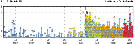
A great deal of earthquake activity has been ongoing in the peninsula in 2020. Earthquakes of M5 were recorded in July this year, by Fagradalsfjall, just west of where the epicenter of the M5.6 earthquake today was. Earthquake history of the Reykjanes Peninsula shows that large earthquakes have occurred in the past in connection with large earthquake swarms. Therefore, there is the possibility of large aftershocks occurring in this swarm. Largest earthquakes in the area can possibly reach M5.5-6. Those types of earthquakes can cause damages within the capital area.
The current earthquake activity in the Reykjanes peninsula that started today can cause increased risk of rockfall. Travellers are urged to show caution beneath steep hills.
Source : Vedur is .
Kamchatka , Karymsky :
VOLCANO OBSERVATORY NOTICE FOR AVIATION (VONA).
Issued: October 21 , 2020
Volcano: Karymsky (CAVW #300130)
Current aviation colour code: ORANGE
Previous aviation colour code: green
Source: KVERT
Notice Number: 2020-189
Volcano Location: N 54 deg 2 min E 159 deg 26 min
Area: Kamchatka, Russia
Summit Elevation: 4874.08 ft (1486 m)
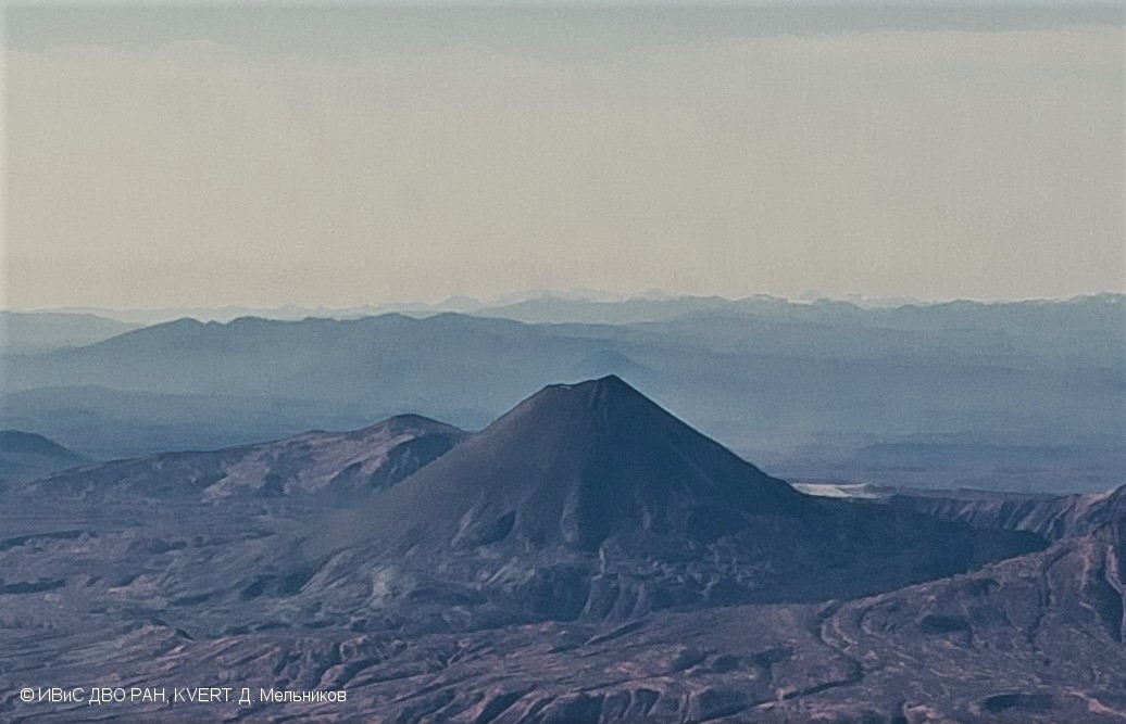
Karymsky volcano fumarole activity on October 13, 2020.
Volcanic Activity Summary:
According to data by AMC Elizovo (from pilots), explosions sent ash up to 4 km a.s.l. about 0230 UTC on 21 October. Ash plume continues to drift to the south-east of the volcano. Last esplosions of Karymsky was noted on 29 July, 2020. KVERT continues to monitor the volcano.
A moderate eruptive activity of the volcano continues. Ash explosions up to 19,700-23,000 ft (6-7 km) a.s.l. could occur at any time. Ongoing activity could affect low-flying aircrafts.
Volcanic cloud height:
13120-16400 ft (4000-5000 m) AMSL Time and method of ash plume/cloud height determination: 20201021/0220Z – Himawari-8
Other volcanic cloud information:
Distance of ash plume/cloud of the volcano: 25 mi (40 km)
Direction of drift of ash plume/cloud of the volcano: SE / azimuth 134 deg
Time and method of ash plume/cloud determination: 20201021/0220Z – Himawari-8
Start time of explosion and how determined: 20201021/0215Z – Satellite data
Source : Kvert.
Photo : D. Melnikov. IVS FEB RAS, KVERT.
Colombia , Doña Juana / Las Ánimas :
Activity bulletin of the Doña Juana and Las Ánimas volcanoes
Volcanic activity continues at: GREEN LEVEL ■ (IV): ACTIVE VOLCANO AND STABLE BEHAVIOR.
From the monitoring of the activity of the VOLCANOES DOÑA JUANA Y LAS ÁNIMAS, the COLOMBIAN GEOLOGICAL SERVICE (SGC) reports that:
From the publication of the bulletin of extraordinary activities of the volcanoes Doña Juana and Las Ánimas (October 16), a daily peak of maximum occurrence of 272 events was highlighted on October 17; After that and until now, there has been a considerable decrease in the occurrence and the energy released, today until 4.30 p.m. 15 earthquakes. It is pointed out that since October 13, there has been an accumulation of 625 events.
Most of these earthquakes are associated with rock fractures, and are preferably located southwest of the Las Ánimas volcano, at epicentral distances of between 2 and 5 km from its summit, at depths of between 3 and 6 km (reference level 4200 m), with magnitudes less than 3.2 on the Richter scale. No relevant change was observed in the other parameters of the monitoring carried out on these volcanoes.
The COLOMBIAN GEOLOGICAL SERVICE remains attentive to the evolution of the volcanic phenomenon and will continue to report the observed changes in due course.
Source et photo : SGC