May 14 , 2020.
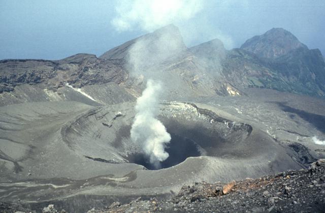
Italy , Stromboli :
Weekly bulletin from May 04, 2020 to May 10, 2020 (issue date May 12, 2020)
SUMMARY OF THE STATUS OF THE ACTIVITY
In light of the monitoring data, it is underlined:
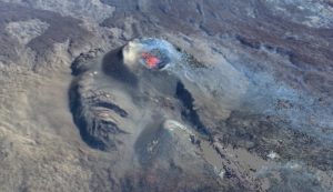
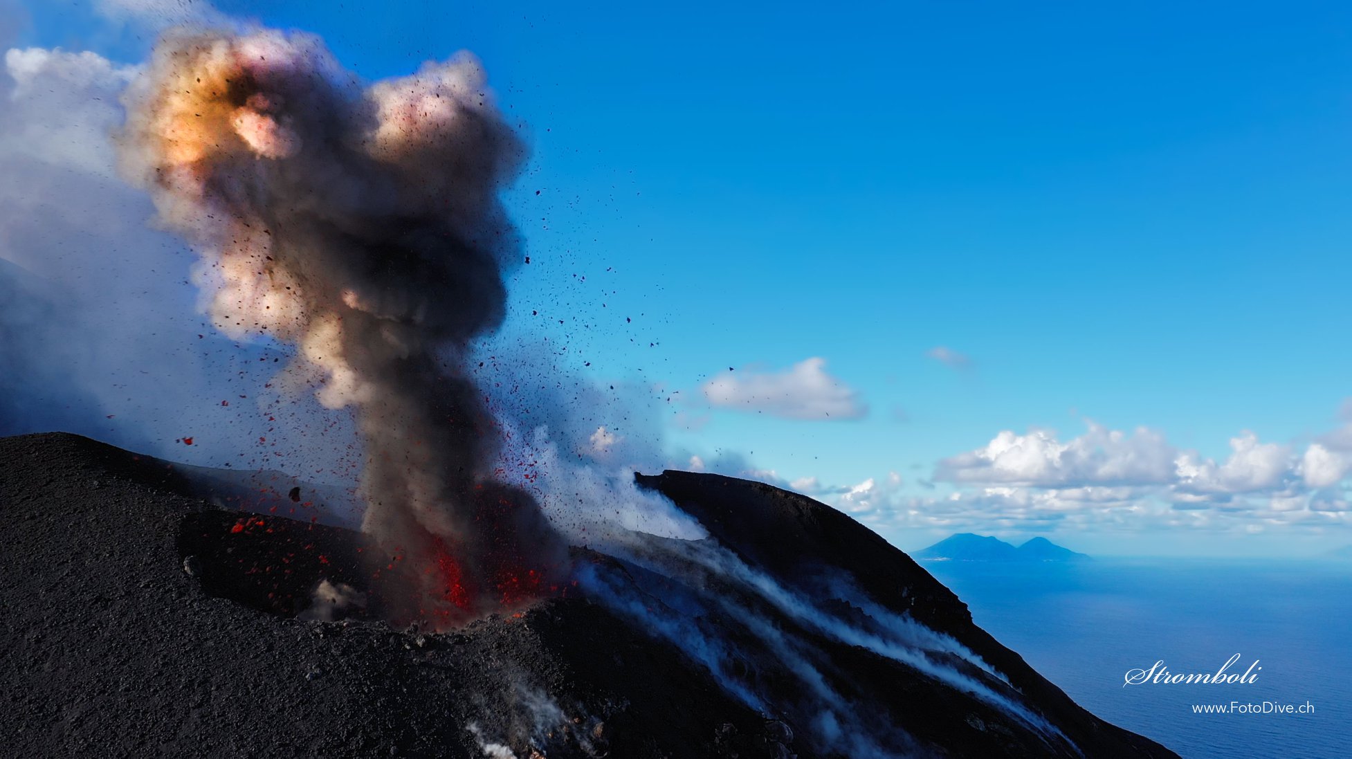
1) VOLCANOLOGICAL OBSERVATIONS: During this period, a normal explosive activity of strombolian type was observed accompanied by degassing activities. The hourly frequency of explosions oscillated between average values (11 events / h on May 6) and average-low values (8 events / h on May 8), except for the first day of observation (May 4) where the frequency was medium-high (16 events / h). The intensity of the explosions was mainly low in the area of the North crater and medium in the area of the Center-South crater.
2) SEISMOLOGY: The seismological parameters do not present significant variations.
4) DEFORMATIONS: Data from the Stromboli soil deformation monitoring networks did not show any significant changes last week.
5) GEOCHEMISTRY: The flow of SO2 is at an average level. The last measurement of the CO2 / SO2 ratio is at an average value (last update on 02/09/2020). The isotopic ratio of helium remains on average values (last update of 09/03/2020). There is no update on the CO2 released by the soil.
6) SATELLITE OBSERVATIONS: The thermal activity in the summit area is at a medium-low level.
The analysis of the images recorded by the cameras placed at an altitude of 400 m, at an altitude of 190 m and at Punta dei Corvi made it possible to characterize the eruptive activity of Stromboli. During the reporting period, the explosive activity was mainly produced by at least 3 (three) eruptive vents located in the area of the North crater and by at least 2 (two) eruptive vents located in the area of the Center-South crater . All the vents are located inside the depression which occupies the crater terrace. Due to an interruption in the video signal, the images were not observed from 04:34 UTC on May 09, 2020 to 06:57 UTC on May 10, 2020.
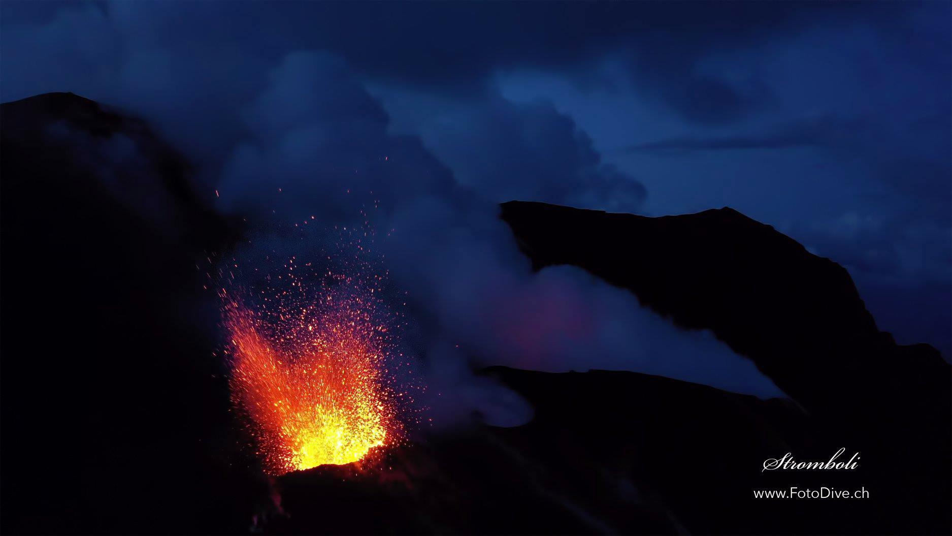
In the North zone, the explosions were mainly of low intensity (less than 80 m in height) emitting coarse materials (lapilli and bombs). During some explosions, the fallout covered the outer slopes of the area overlooking the Sciara del Fuoco. The average frequency of explosions in the North zone varied between 4 and 12 events / h. The explosive activity of the Center-South zone produced explosions of mainly fine materials (ashes) mixed with coarse materials of medium intensity (less than 150 m in height). The frequency of explosions in the Center-South zone varied between 2 and 5 events / h.
The amplitude of the volcanic tremor went from low to medium-low values, at the beginning of the week, to generally low values from 8/05. … / …
Source : INGV.
Read the whole article : file:///C:/Users/Utilisateur/AppData/Local/Packages/Microsoft.MicrosoftEdge_8wekyb3d8bbwe/TempState/Downloads/BollettinoStromboli20200512%20(1).pdf
Photos : Willie FotoDive ,
Philippines , Mayon :
LAHAR ADVISORY FOR MAYON VOLCANO 13 May 2020 15:00 PM
Based on its Severe Weather Bulletin # 8 issued at 11:00 AM today (May 13, 2020), the Philippine Atmospheric Geophysical and Astronomical Services Administration (PAGASA) forecasts that Albay will be experiencing moderate to heavy rains tomorrow, 14 May 2020, due to Tropical Storm “AMBO”.
Due to this development, DOST-PHIVOLCS strongly recommends increased vigilance and readiness of communities in pre-determined zones of lahar hazards in Mayon Volcano. Prolonged and heavy rainfall may generate post-eruption lahars on major channels draining the Mayon Volcano edifice by incorporating loose material from thick pyroclastic density current (PDC) deposits and remnant ashfall from the January-March 2018 eruption. The bulk of erodible PDC deposits occupy the watershed areas of the Miisi, Mabinit, Buyuan and Basud Channels.
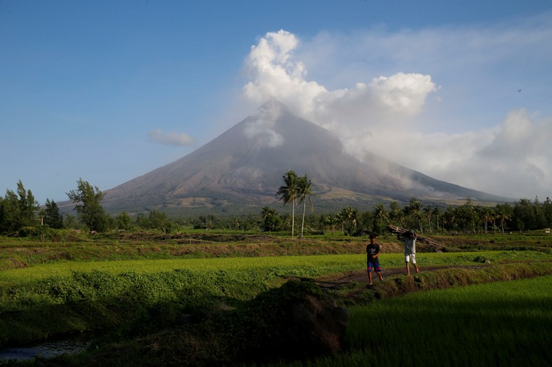
In addition, older and erodible eruption deposits occupy the watershed areas on the eastern and western slopes of the edifice and can be remobilized as non-eruption lahars by erosion of banks and channel beds. Mayon lahars can threaten communities along the middle and lower slopes and downstream of these channels with inundation, burial and wash away.
DOST-PHIVOLCS, therefore, warns of potential lahars and sediment-laden streamflows on all river channels draining the slopes of Mayon Volcano, particularly the Miisi, Binaan, Anoling, Quirangay, Maninila, Masarawag, Muladbucad, Nasisi, Mabinit, Matan-ag, and Basud Channels, that may be generated by heavy rainfall brought about by Tropical Storm “AMBO”. Communities and local government units beside these drainages are advised to be additionally vigilant and to move residents to high ground should heavy rains occur.
Source : Phivolcs.
Photo : Czar Dancel / Manila Bulletin
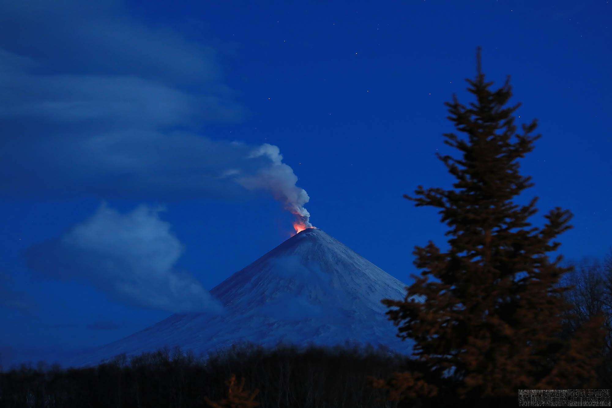
Kamchatka , Klyuchevskoy :
56.056°N, 160.642°E
Elevation 4754 m
KVERT reported that Strombolian activity at Klyuchevskoy was visible during 1-8 May along with a bright thermal anomaly identified in satellite images. A lava flow continued to advance down the Apakhonchich drainage on the SE flank. An ash plume drifted 22 km SE on 2 May. The Aviation Color Code remained at Orange.
VOLCANO OBSERVATORY NOTICE FOR AVIATION (VONA).
Issued: May 13 , 2020
Volcano: Klyuchevskoy (CAVW #300260)
Current aviation colour code: ORANGE
Previous aviation colour code: orange
Source: KVERT
Notice Number: 2020-83
Volcano Location: N 56 deg 3 min E 160 deg 38 min
Area: Kamchatka, Russia
Summit Elevation: 15580 ft (4750 m)
Volcanic Activity Summary:
A moderate explosive-effusive eruption of the volcano continues. The Strombolian and sometimes Vulcanian types of volcanic activity is observing. The lava flow continues to move on the southeastern flank of the volcano (the Apakhonchich chute), phreatic bursts and collapse of loose slag material accompany this process. According to visual and satellite data, a gas-steam plume containing some amount of ash is extending about 25 km to the south-south-east of the volcano.
A moderate explosive eruption of the volcano continues. Ash explosions up to 16,400-23,000 ft (5-7 km) a.s.l. could occur at any time. Ongoing activity could affect low-flying aircraft.
Volcanic cloud height:
16400-18040 ft (5000-5500 m) AMSL Time and method of ash plume/cloud height determination: 20200513/2035Z – Video data
Other volcanic cloud information:
Distance of ash plume/cloud of the volcano: 16 mi (25 km)
Direction of drift of ash plume/cloud of the volcano: SSE / azimuth 167 deg
Time and method of ash plume/cloud determination: 20200513/1957Z – NOAA 19 (4m5)
Sources: KVERT , GVP .
Photos : Volkstat ru .
Japan , Sakurajima ( Aira) :
31.593°N, 130.657°E
Elevation 1117 m
JMA reported that during 4-11 May incandescence from Minamidake Crater (at Aira Caldera’s Sakurajima volcano) was visible nightly. There were four eruptive events with plumes rising as high as 2.3 km above the crater rim.
Three explosions were recorded; an explosion at 0531 on 9 May produced an ash plume that rose 4.2 km and ejected material 600-900 m away from the crater. JMA noted that ash plumes had not risen higher than 4 km since 8 November 2019. The Alert Level remained at 3 (on a 5-level scale).
Source: Japan Meteorological Agency (JMA) , GVP.
Video : 桜島
Japan , Suwanosejima :
29.638°N, 129.714°E
Elevation 796 m
JMA reported that during 1-8 May explosions occurred twice a day at Suwanosejima’s Ontake Crater and produced plumes that rose as high as 1 km above the crater rim. Material was ejected 400 m from the crater. Crater incandescence was visible nightly. Rumbling sounds were noted in a village 4 km SSW. The Alert Level remained at 2 (on a 5-level scale).
Source: Japan Meteorological Agency (JMA) , GVP .
Photo : Yukio Hayakawa, 1998 (Gunma University).