July 19 , 2020.
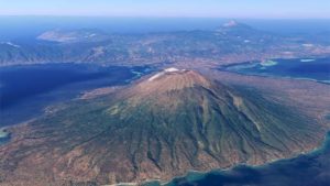
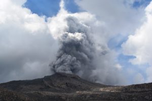
Italy , Stromboli :
PRESS RELEASE STROMBOLI [n. 1]
The National Institute of Geophysics and Volcanology, Etneo Observatory, reports that the monitoring networks recorded an explosion of strong intensity at 06:23 (04:23 UTC).
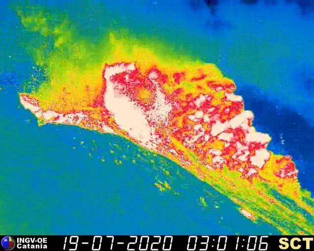
At 3:00 UTC, according to the surveillance cameras , an explosion of major intensity was observed. The products generated by the explosion fell on the crater terrace and along the Sciara del Fuoco. From a seismic point of view, the phenomenon was characterized by a short sequence of explosive events and by an increase in the amplitude of the tremor until 03:10 UTC.
Further updates will be communicated shortly.
Source : INGV.
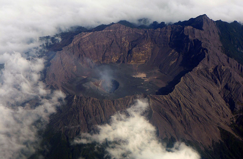
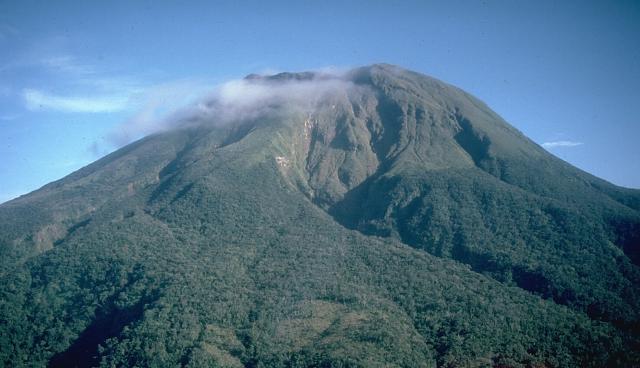
Indonesia , Raung :
Press release . Increase of the activity status of G. Raung, East Java from level I (normal) to level I (alert), July 17, 2020.
G. Raung (other name: Rawon) is one of the active volcanoes in East Java, with a maximum height reaching 3332 meters above sea level. This volcano is a stratovolcano with a main crater in the Raung caldera and other craters namely Tegal Alun-alun and Tegal Brungbung. The Raung caldera has an elliptical shape with a size of 1750 x 2250 m, a depth of 400 to 550 m from the edge of the mountain.
The activity level of G. Raung has been at level I (normal) since October 24, 2016.
Surveillance data:
Visual: From January 1 to July 16, 2020 at. 07.52 WIB, the volcano was clearly visible until it was covered in fog. The smoke from the crater is white with medium / high intensity about 50 meters above the summit. On July 16, 2020 at 10:52 a.m. PST, we observed an increase in the height of the smoke emitted at 100 m over the top of the peak accompanied by a color change to brownish white. At 1:56 p.m. West Indonesian Time, there was a color change in the emission column, turning white / gray, with a height of 100 m from the top of the peak. 60 emissions / eruptions have been observed since 10:52 a.m. WIB, in the form of columns of gray and reddish ash, from a height of 50 to 200 m.
On July 17, 2020, between 12 a.m. and 6 a.m., emissions still occur (26 times), resulting in a column of brown ash with low to moderate intensity and a height of 50 to 200 m above the peak / crater.
Seismicity:
The number and type of earthquakes recorded from January 1 to July 16, 2020 at 10:00 a.m., were dominated by distant tectonic earthquakes, local tectonics, an earthquake felt on March 19, 2020, and earthquakes since July 13, 2020. Earthquakes continued and increased in number since July 16, 2020 10:52 a.m., followed by the emergence of non-harmonic tremors and emission earthquakes. On July 17, 2020, until 06:00 WIB, 26 emission earthquakes and 20 non-harmonic tremor vibrations were recorded.

Analysis:
The height of the gas / ash emission column and the color of the column began to change on July 16, 2020. The color of the emission column indicates the presence of ash returned to the surface.
The amount of earthquake increased and followed by the appearance of other types of volcanic earthquakes (tremor and emission), thus indicating the existence of a magma supply deep below the summit crater of Mount Raung
Potential danger:
The distribution of materials from the ashes released on July 16 and 17, 2020 is still around Mount Raung crater / peak, which is a disaster prone area III. However, ash dispersal can go to more distant areas depending on the direction and speed of the wind.
Conclusion:
The volcanic activity of Mount Raung both in terms of visual observation data and seismicity, began to show an increase, and then the level of volcanic activity of Mount Raung increased from level I (normal) to level II (Vigilant), since July 17, 2020, at 2:00 p.m. WIB.
Recommendation:
At level II activity level (watchful) so that people / visitors / tourists must not have activities within a radius of 2 km around the crater / peak.
Source : PVMBG.
Photos : Volcanohotspot , Wikimapia .
Philippines , Bulusan :
BULUSAN VOLCANO BULLETIN: 19 July 2020 08:00 A.M.
Bulusan Volcano’s monitoring network recorded forty-eight (48) volcanic earthquakes during the 24-hour observation period. Ground deformation data from continuous GPS measurements indicate a cycle of inflation followed by deflation of the edifice beginning late February 2020, while the long-term trend since May 2019 denote that the edifice is still deflated. These parameters indicate that volcanic processes are underway beneath the edifice that may be caused by deep-seated degassing or hydrothermal activity or magmatic intrusion.
Alert Level 1 (Abnormal) status prevails over Bulusan Volcano, which means that it is currently in an abnormal condition. Local government units and the public are reminded that entry into the four-kilometer radius Permanent Danger Zone (PDZ) is strictly prohibited and that vigilance within the two-kilometer Extended Danger Zone (EDZ) on the southeastern sector must be exercised due to the increased possibilities of sudden and hazardous phreatic eruptions. Civil aviation authorities must also advise pilots to avoid flying close to the volcano’s summit as ash from any sudden phreatic eruption can be hazardous to aircraft. Furthermore, people living within valleys and along river/stream channels especially on the southeast, southwest and northwest sector of the edifice should be vigilant against sediment-laden stream flows and lahars in the event of heavy and prolonged rainfall. DOST-PHIVOLCS is closely monitoring Bulusan Volcano’s condition and any new development will be communicated to all concerned stakeholders.
Source : Phivolcs .
Photo : Wikipedia .
Mexico , Popocatepetl :
July 17, 11:00 a.m. (July 17, 4:00 p.m. GMT).
In the past 24 hours, 94 exhalations accompanied by water vapor, volcanic gases and small amounts of ash have been identified through the Popocatépetl volcano monitoring system. The ash emissions were dispersed in the West, Northwest (W-NW) sector. In addition, 136 minutes of tremors were recorded.
An incandescence was observed at night in the crater.
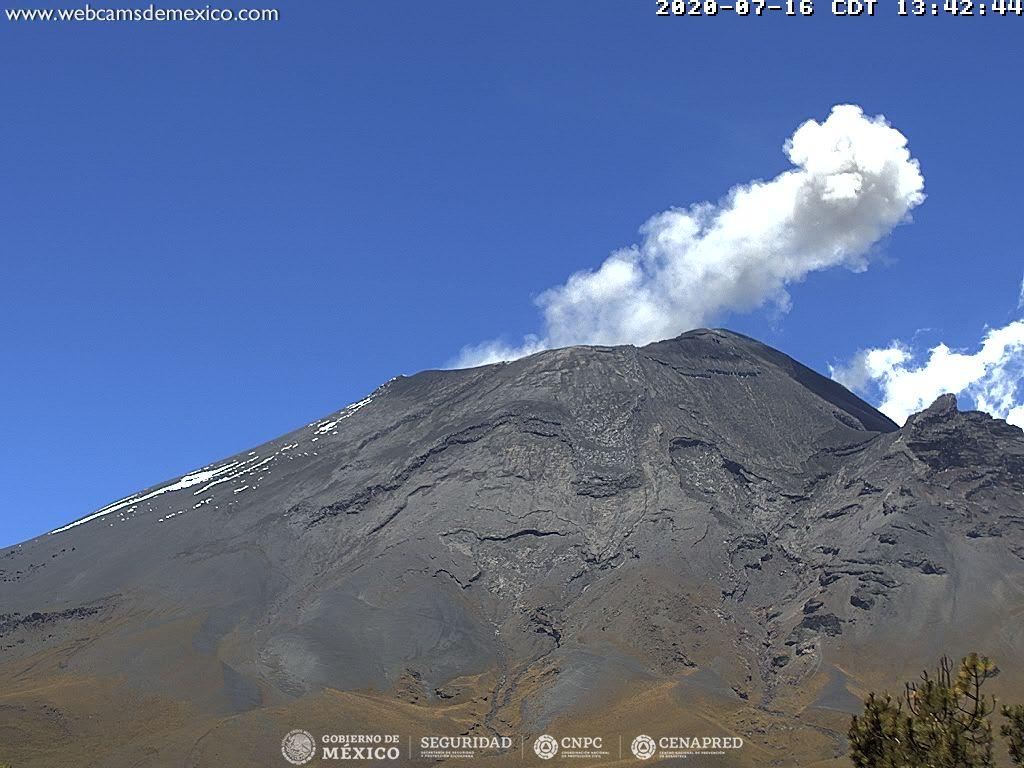
At the time of this report, there is visibility. During the morning there were volcanic gas emissions and small amounts of ash scattered west (W).
CENAPRED urges NOT TO APPROACH the volcano and especially the crater, because of the danger involved by the fall of ballistic fragments and, in the event of heavy rains, to move away from the bottom of the ravines because of the danger of lava flows. mud and debris.
The Popocatépetl volcanic alert signal light is in YELLOW PHASE 2.
Source et photos : Cenapred
Russia / Kuril Islands , Ebeko :
VOLCANO OBSERVATORY NOTICE FOR AVIATION (VONA).
Issued: July 19 , 2020
Volcano: Ebeko (CAVW #290380)
Current aviation colour code: ORANGE
Previous aviation colour code: orange
Source: KVERT
Notice Number: 2020-161
Volcano Location: N 50 deg 41 min E 156 deg 0 min
Area: Northern Kuriles, Russia
Summit Elevation: 3791.68 ft (1156 m)
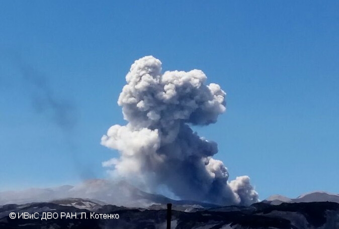
Volcanic Activity Summary:
A moderate eruptive activity of the volcano continues. According to visual data by volcanologists from Severo-Kurilsk, explosions sent ash up to 2.6 km a.s.l., an ash cloud is drifting to the southeast of the volcano.
This activity of the volcano continues. Ash explosions up to 19,700 ft (6 km) a.s.l. could occur at any time. Ongoing activity could affect low-flying aircraft and airport of Severo-Kurilsk.
Volcanic cloud height:
8528 ft (2600 m) AMSL Time and method of ash plume/cloud height determination: 20200719/0024Z – Visual data
Other volcanic cloud information:
Distance of ash plume/cloud of the volcano: 2 mi (3 km)
Direction of drift of ash plume/cloud of the volcano: SE
Time and method of ash plume/cloud determination: 20200719/0024Z – Visual data
Source : Kvert.
Photo : L. Kotenko, IVS FEB RAS , 2017.