Avril 19 , 2020.
Alaska , Great Sitkin :
52°4’35 » N 176°6’39 » W,
Summit Elevation 5709 ft (1740 m)
Current Volcano Alert Level: ADVISORY
Current Aviation Color Code: YELLOW
Small earthquakes have continued to occur at Great Sitkin over the last week, at a rate above the background level. Satellite and web camera views were obscured by clouds for most of the week, but rare clearer views showed no sign of activity at the surface. AVO is closely monitoring the volcano for other signs of unrest that may indicate increased activity or likelihood of an eruption.
Great Sitkin Volcano is monitored with a local real-time seismic network, which will typically allow AVO to detect changes in unrest that may lead to an explosive eruption. Rapid detection of an ash-producing eruption would be accomplished using a combination of seismic, infrasound, lightning, and satellite data.
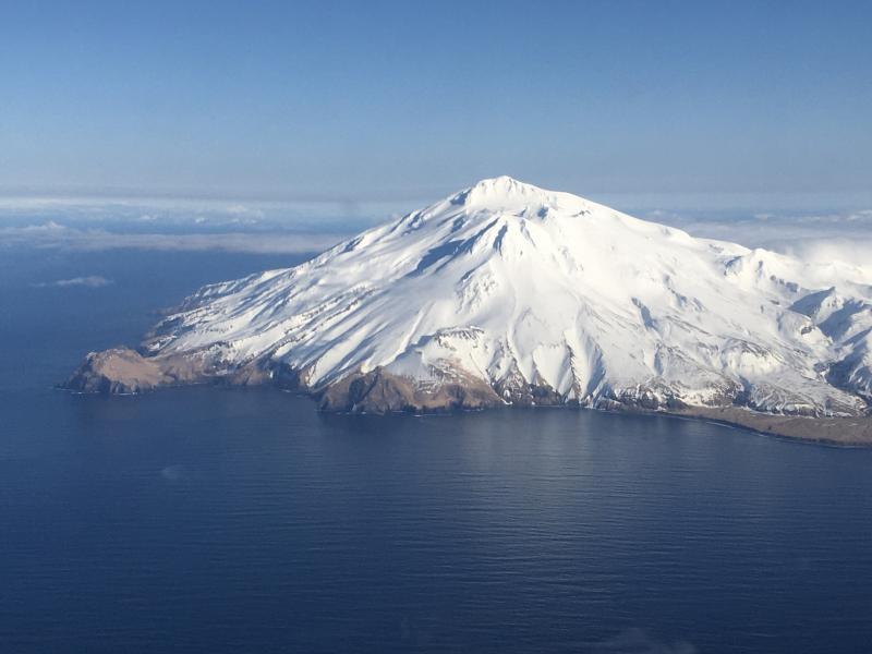
Great Sitkin Volcano is a basaltic andesite volcano that occupies most of the northern half of Great Sitkin Island, a member of the Andreanof Islands group in the central Aleutian Islands. It is located 43 km (26 miles) east of the community of Adak. The volcano is a composite structure consisting of an older decapitated volcano and a younger parasitic cone with a 2-3 km diameter summit crater. A steep-sided lava dome, emplaced during an eruption in 1974, occupies the center of the crater. Great Sitkin erupted at least three times in the 20th century, most recently in 1974. That eruption produced a lava dome and at least one ash cloud that likely exceeded an altitude of 25,000 ft above sea level. A poorly documented eruption occurred in 1945, also producing a lava dome that was partially destroyed in the 1974 eruption. Within the past 280 years a large explosive eruption produced pyroclastic flows that partially filled the Glacier Creek valley on the southwest flank.
Source : AVO
Photo : Fischer, Ed
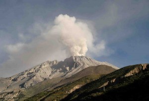
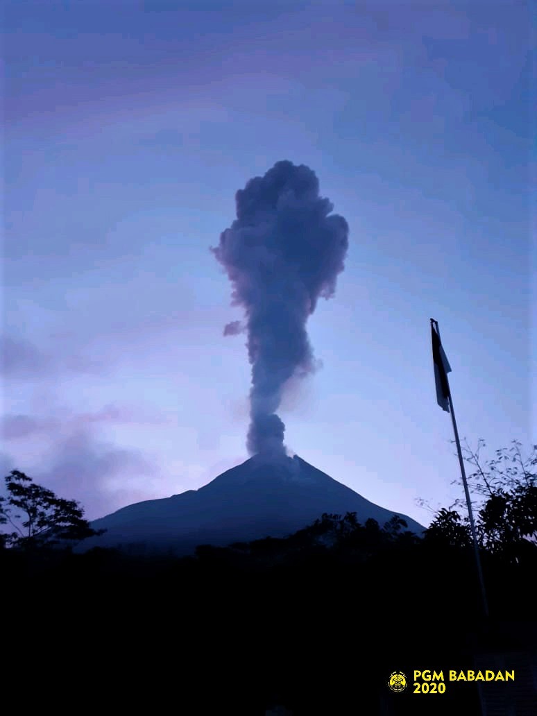
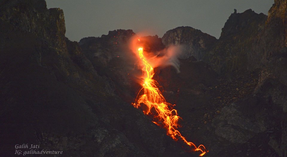
Indonesia , Merapi :
Activity report of the Merapi volcano from April 10 to 16, 2020
OBSERVATION RESULTS
Visuals
The weather around Mount Merapi is generally sunny in the morning and at night, while the day until evening is foggy. There is white smoke, from thin to thick with a low pressure. The maximum smoke height of 450 m was observed from the observation post of Mount Merapi Babadan on April 16, 2020 at 6:10 am.
At 9:10 a.m. on April 10, 2020, an eruption occurred with a column of eruption smoke reaching 3,000 m. The eruption was recorded on a seismogram with an amplitude of 75 mm and a duration of 103 seconds. The wind direction was to the northwest when the eruption occurs.
Morphological analysis of the crater area based on photos of the Southeast sector did not show any change in the morphology of the dome. The volume of the lava dome based on measurements using aerial photos with drones on February 19, 2020 was 291,000 m3.
Seismicity:
This week, the seismicity of Mount Merapi showed:
1 eruption earthquake
42 emission earthquakes (DG),
1 deep volcanic earthquake (VTA),
2 shallow volcanic earthquakes (VTB),
67 multiple phase earthquakes (MP),
16 avalanche earthquakes (RF),
13 low frequency earthquakes (LF)
16 tectonic earthquakes (TT).
The intensity of the seismicity this week is higher than last week.
Deformation
The RK2 and RK3 reflectors cannot be measured due to the impact of the March 3, 2020 eruption. The GPS Selo – Market Disbanded distance is not measurable because the equipment is under maintenance.
Rain and lahars:
This week, April 12, 2020, there was rain at the Mount Merapi observation post with the highest rainfall intensity of 20 mm / hour at the Kaliurang post. There were no lahars or additional flows in the rivers that descend from Mount Merapi.
Conclusion:
Based on the results of the visual and instrumental observations, it was concluded that:
1. The lava dome is currently in a stable state.
2. The volcanic activity of Mount Merapi is still quite high and is determined by the level of activity « WASPADA ».
3. The current potential danger is in the form of hot clouds from the collapse of the lava dome and emissions of volcanic materials resulting from explosive eruptions.
Source : BPPTKG
Photos : bpptkg , Yohannes Tyas Galih Jati.
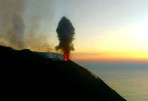
Kamchatka , Klyuchevskoy :
VOLCANO OBSERVATORY NOTICE FOR AVIATION (VONA).
Issued: 20200418/2243Z
Volcano: Klyuchevskoy (CAVW #300260)
Current aviation colour code: ORANGE
Previous aviation colour code: orange
Source: KVERT
Notice Number: 2020-53
Volcano Location: N 56 deg 3 min E 160 deg 38 min
Area: Kamchatka, Russia
Summit Elevation: 15580 ft (4750 m)
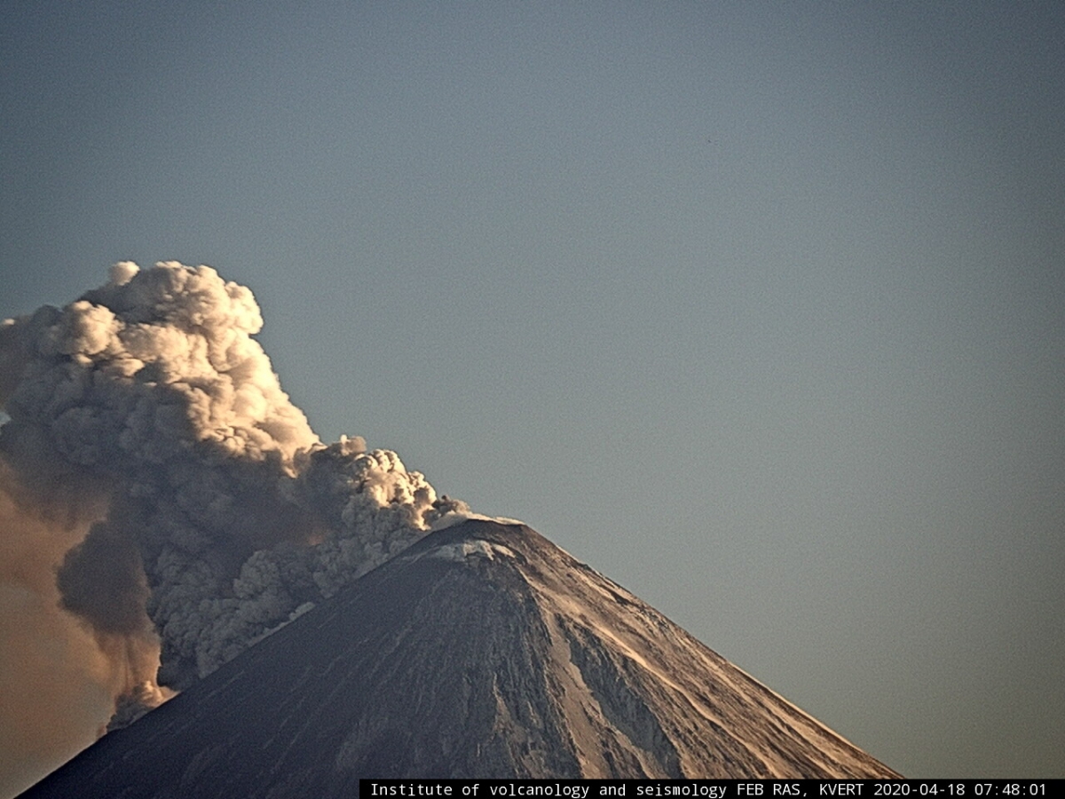
Volcanic Activity Summary:
A moderate explosive eruption of the Strombolian and sometimes Vulcanian types of the volcano continues. The lava flow began to move on the southeastern flank of the volcano. According to satellite data, a gas-steam plume containing some amount of ash is extending about 100 km to the north-east of the volcano.
A moderate explosive eruption of the volcano continues. Ash explosions up to 16,400-23,000 ft (5-7 km) a.s.l. could occur at any time. Ongoing activity could affect low-flying aircraft.
Volcanic cloud height:
16400-18040 ft (5000-5500 m) AMSL Time and method of ash plume/cloud height determination: 20200418/2210Z – Himawari-8
.
Other volcanic cloud information:
Distance of ash plume/cloud of the volcano: 62 mi (100 km)
Direction of drift of ash plume/cloud of the volcano: ENE / azimuth 77 deg
Time and method of ash plume/cloud determination: 20200418/2210Z – Himawari-8
Source : Kvert .
Photos : IVS FEB RAS, KVERT , Volkstat ru .
Costa Rica , Turrialba / Poas / Rincon de la Vieja / Irazu :
Turrialba volcano:
Lat: 10.025 ° N; Long: 83,767 ° W;
Height: 3340 m above sea level
Current activity level: 2 (active volcano)
Potentially associated hazards: gas, ash emission, proximal ballistic emissions.
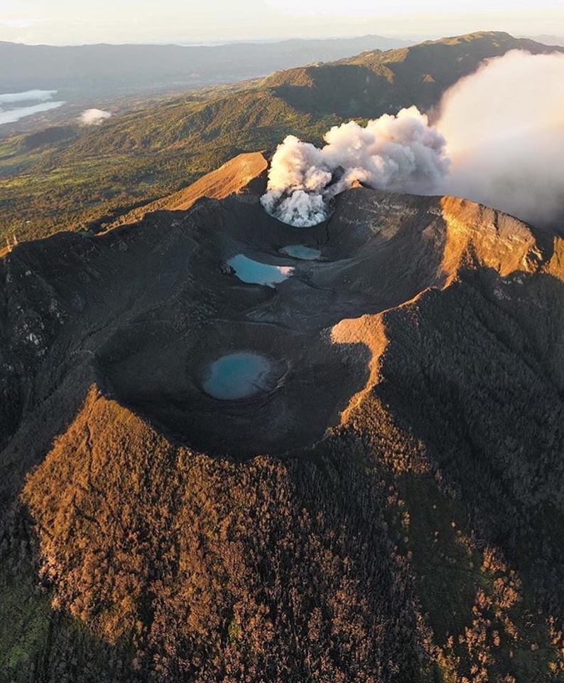
No ash emission was detected. Seismicity remains stable with few TV type events, short tremors and frequent LP type events but without significant pattern. Geodetic measurements show a tendency to contract the Irazú-Turrialba massif and the summit of the Turrialba volcano, a trend unchanged from the previous months. The CO 2 / SO 2 and H 2 S / SO 2 gas ratios show an increase which suggests a greater interaction with the hydrothermal system. The flow of SO 2 remains stable and low (<200 t / d).
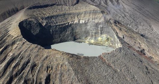
Poás Volcano:
Lat: 10.2 ° N; Long: 84 233 ° W;
Height: 2780 m above sea level
Current activity level: 3 (active volcano)
Potentially associated hazards: gas, ash emission, phreatic eruptions, proximal ballistic emissions.
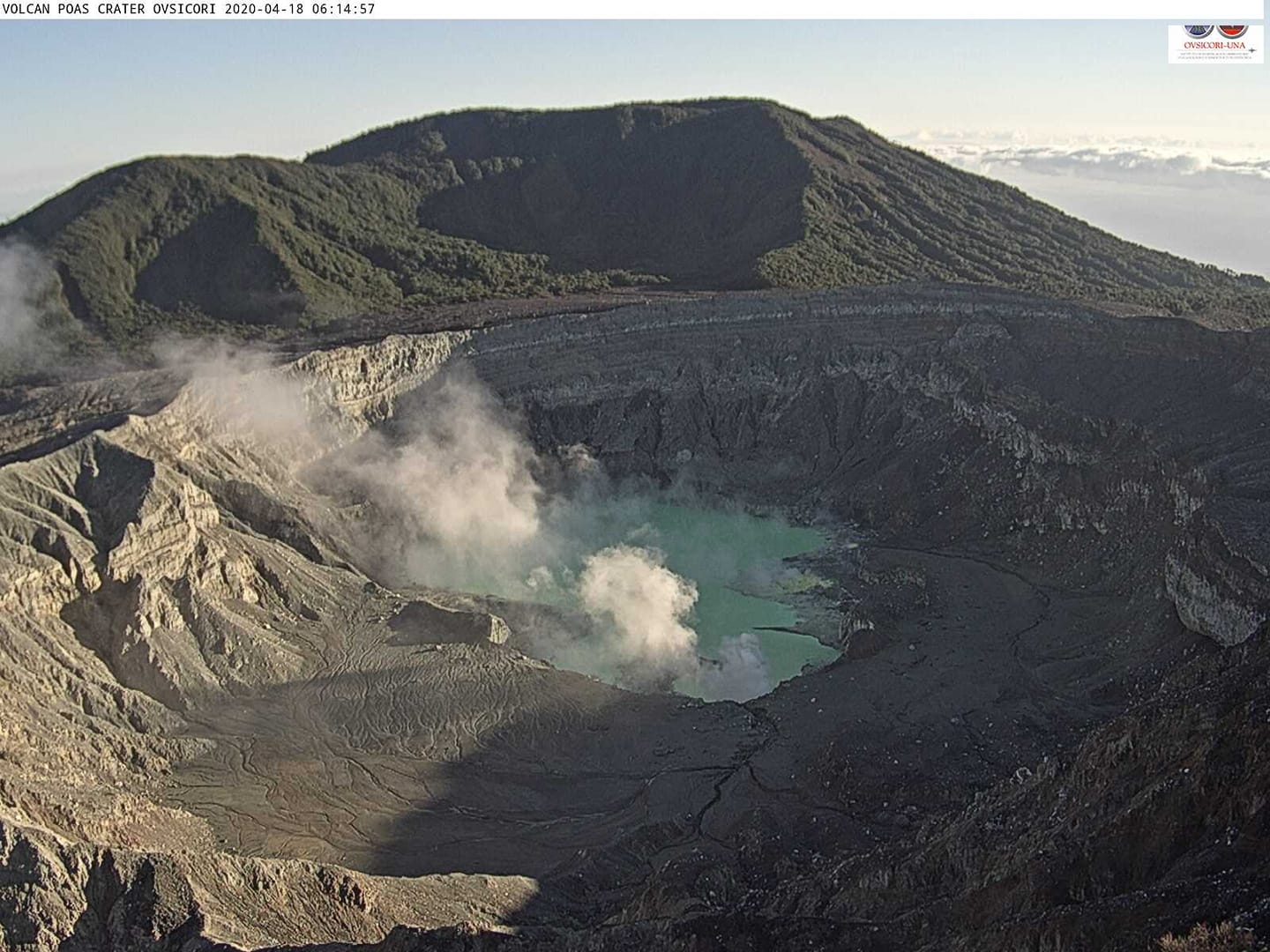
No eruption was detected. Seismic activity is maintained with a variable number of LP type events within a stable range. Up to 300 short tremors were recorded daily between April 5 and 6 before disappearing on April 9, there is a background tremor that varies in amplitude, very few TV-type events occur. There is no significant deformation. The CO 2 / SO 2 ratio is stable despite a peak on April 9. The H 2 S / SO 2 ratio remains stable with low values. The SO 2 flow peaked on April 1 (> 1,300 t / d) but quickly returned to normal values between 100 and 300 t / d. High concentrations of SO 2 have been recorded at the national park level with several peaks> 10 ppm. The level of the lake continues to drop.
Rincon de la Vieja volcano:
Lat: 10.83 ° N; Long: 85.324 ° W;
Height: 1895 m above sea level
Current activity level: 3 (erupting volcano)
Potentially associated hazards: gas, phreatic eruptions, proximal ballistic emissions, lahars.
Small, frequent eruptions have been detected, up to several per day. Some were able to reach the edge of the crater but without generating lahars (for example April 4, 6 or April 13). The number of LP type events is stable, there are no « Tornillos » type events. Most of the time, the tremor is continuous until a small eruption occurs, then it disappears for an indefinite interval, sometimes short, but some eruptions also occur without stopping the tremor. It is observed that the acoustic energy is greater than the seismic energy for the eruptions in 2020 compared to the eruptions in 2019, which suggests more superficial events or that the environment where these eruptions are generated is largely fractured. The geodetic measurements show a stability with a certain extension and inflation but in the range of uncertainty. The redox potential of a hot spring in the North shows a rapid decrease.
https://www.facebook.com/OVSICORI/videos/655294085253740/
At 09:29:00 local time on April 18, 2020, an eruption was recorded on the Rincon de la Vieja volcano, with a column that rose 200 meters above the height of the crater and 2116 meters above above sea level. (6,940.48 ft).
Duration of activity: less than a minute.
Seismic activity is similar to that of yesterday.
The wind direction is unknown at this time.
When conditions allow, a plume is observed sporadically from the crater. At 9:29 a.m., a plume of vapor without solid matter was observed and could be linked to an intracrater phreatic eruption. The tremor with a frequency of about 1 Hz is semi-continuous and of low amplitude.
Irazú Volcano:
Lat: 9.979 ° N; Long: 83.852 ° W;
Altitude: 3432 m above sea level
Current activity level: 1 (active)
Potentially associated hazards: landslides.
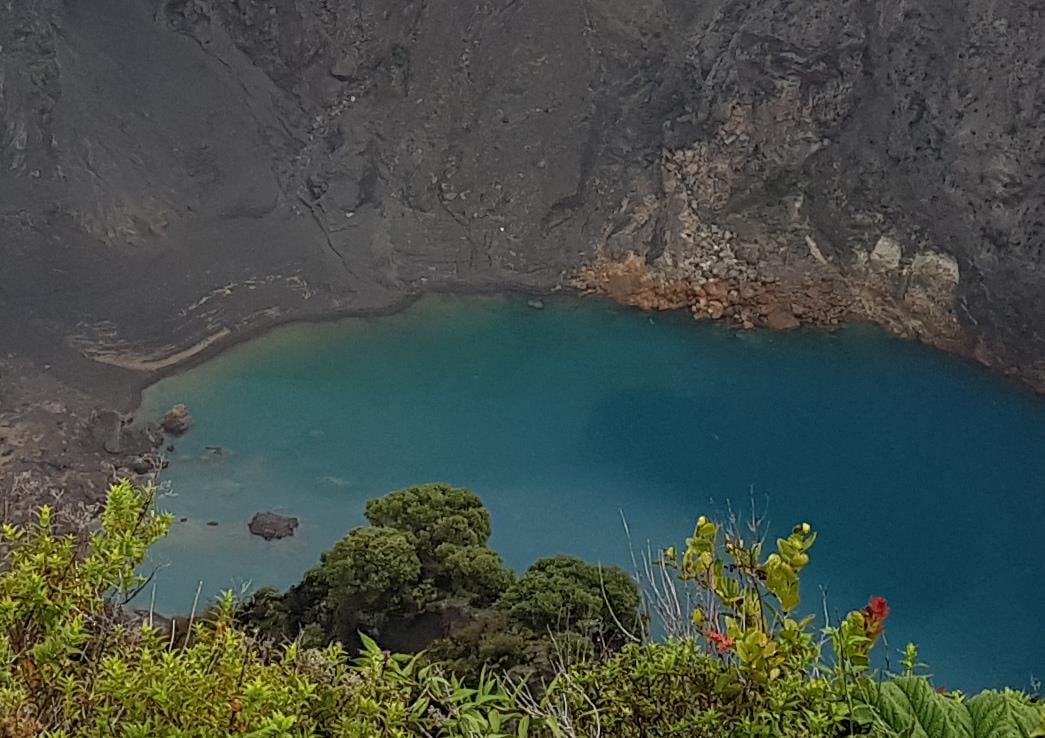
Seismic activity is low with some sporadic distal VT type events, some LP type events and smaller landslides over time and less frequent. GPS measurements show a stable sliding speed in the tower sector. A 1.1 magnitude shallow earthquake was reported on April 11, which did not affect the speed of the slide.
Source : Ovsicori .
Photos : jcarvaja17 , Chris Allen de Sunquest Helitours , Theresa Lopez , rsn .
Video : Ovsicori .