Mach 09 , 2020.
Indonesia , Dukono :
VOLCANO OBSERVATORY NOTICE FOR AVIATION – VONA.
Issued: March 08 , 2020.
Volcano: Dukono (268010)
Current Aviation Colour Code: ORANGE
Previous Aviation Colour Code: orange
Source: Dukono Volcano Observatory
Notice Number: 2020DUK11
Volcano Location: N 01 deg 41 min 35 sec E 127 deg 53 min 38 sec
Area: North Maluku, Indonesia
Summit Elevation: 3933 FT (1229 M)
Volcanic Activity Summary:
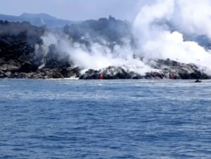
Eruption with volcanic ash cloud at 00h31 UTC (09h31 local).
Volcanic Cloud Height:
Best estimate of ash-cloud top is around 5853 FT (1829 M) above sea level, may be higher than what can be observed clearly. Source of height data: ground observer.
Other Volcanic Cloud Information:
Ash-cloud moving to south
Remarks:
Eruption and ash emission is continuing.
Source : Magma Indonésie .
Photo : Rainwater Media via Sherine France.
Indonesia , Semeru :
Press release on the activity of Mount Semeru, March 8, 2020.
Mount Semeru is one of the active volcanoes in Indonesia. Geographically, the peak is located at 08 ° 06’30 « South latitude and 112 ° 55’00 » East longitude with the height of the peak (Mahameru) at 3676 m above sea level. The level of activity of G. Semeru since May 2, 2012 is at level II (Waspada).
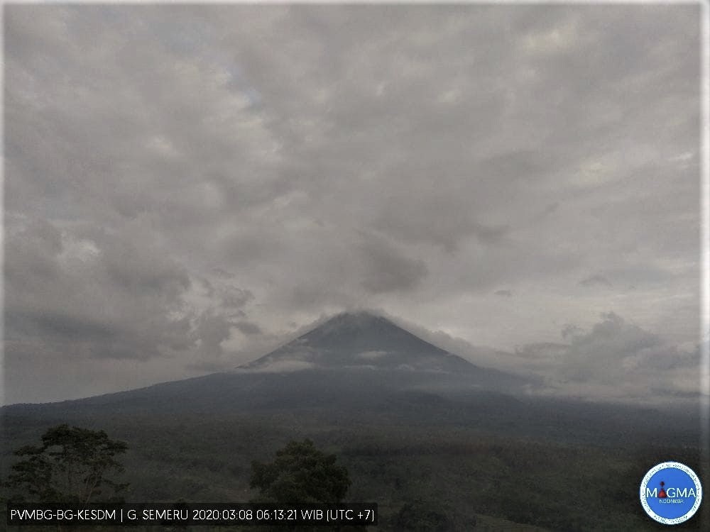
Visual observation by G. Semeru, 3/8/2020 at 06.13. A white gas emission of high intensity and a height of 50 to 100 m is observed above the top of the crater.
Monitoring data:
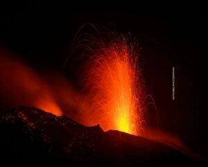
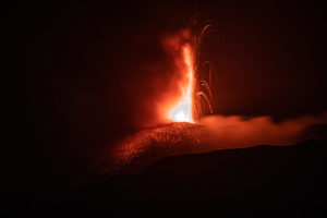
1) Visual: visually at the beginning of March 2020, this eruption took place continuously producing a column of eruption with a maximum height of 200 meters above the crater. The eruption column is gray / black in color. During periods of calm, a thin continuous column of white gas with a maximum height of 100 m was observed accompanied by a silent glow from a height of 10 to 50 m in the crater Jonggring Seloko. An incandescent lava flow activity began to be observed since the end of February 2020 with a sliding distance of 500-1000 m towards Besuk Kembar, Besuk Bang and Besuk Kobokan. On March 3, 2020, a hot cloud descended from the end of the lava flow towards Besuk Kembar and Besuk Bang to 2250 m or 3 km under the summit crater. On March 8, 2020, avalanche activities still take place with a maximum sliding distance of 700 m towards Twin Besuk and Besuk Kobokan with a fluctuating number of events.
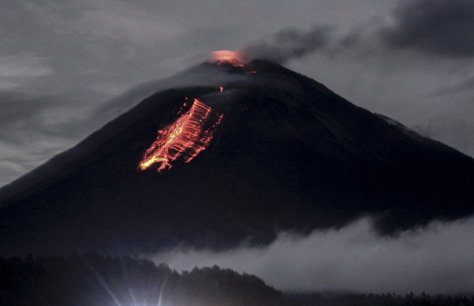
The lava flows from the crater of Mount Semeru, seen from the village of Pranajiwo near Lumajang in eastern Java. (Photo Antara / Umarul Faruq)
2) Seismicity: The seismic activity of Mount Semeru is always high, dominated by earthquakes of eruption, avalanche and emission type. On March 5, 2020, the number of eruption-type earthquakes increased, and then decreased the following day. Avalanche earthquakes increased at the end of February and lava flows were recorded on February 26, 2020. The interval of eruption earthquakes occurs once every hour and still has the potential for an eruption . The recorded harmonic earthquakes have fluctuated.
Until the beginning of March 2020, the number of eruption earthquakes was higher than that of the avalanche earthquakes, which indicates that G. Semeru is currently in a constructive phase (formation of volcanic bodies by materials erupting).
Analysis:
The eruptive activity and the puffs of gas continue from the Jonggring Seloko crater. This shows that the supply or pressure of magma continues to occur accompanied by an increase in fluid (gas, liquid and solids) to a shallower depth, as the lava flows. Hot avalanche clouds occur due to gravity at the end of the unstable lava flow. The appearance of harmonic tremors without accompanying volcanic earthquakes (shallow volcanic or deep volcanic) shows that the system is now open. The current eruption is the eruptive character of G. Semeru. The fairly close interval of earthquakes of eruptions shows that there has so far been no accumulation of energy capable of causing more intense eruptions.
Source : PVMBG.
Photos : Magma Indonésie , Antara / Umarul Faruq .
Philippines , Taal / Mayon :
TAAL VOLCANO BULLETIN: 09 March 2020 8:00 A.M.
Activity in the Main Crater in the past 24 hours has been characterized by moderate emission of steam-laden plumes rising 300 to 500 meters high before drifting southwest. The Taal Volcano Network recorded nineteen (19) volcanic earthquakes that are associated with rock fracturing processes beneath and around the edifice.
MAYON VOLCANO BULLETIN: 09 March 2020 08:00 A.M.
Mayon Volcano’s seismic monitoring network recorded ten (10) volcanic earthquakes during the 24-hour observation period. Moderate emission of white steam-laden plumes that crept downslope before drifting east-northeast, west-northwest, and north-northeast to north-northwest was observed. Sulfur dioxide (SO2) emission was measured at an average of 478 tonnes/day on 23 February 2020. Recent electronic tilt data showed inflation of the middle to upper portions of the volcanic edifice that began in the last quarter of 2019. This follows an inflationary trend that began in February 2019 as recorded by continuous GPS monitoring.
Source : Phivolcs.
Photo : Taal / William Enriquez .
Guatemala , Fuego :
Type of activity: Vulcanian
Morphology: composite stratovolcano
Atmospheric conditions: clear.
Wind: North at 8 km / h
Precipitation: 0.4 mm.
Activity:
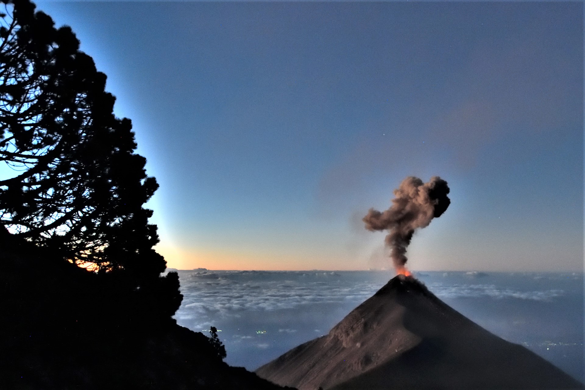
The Fuego Volcano Observatory reports that there are small, moderate and some strong explosions, in a range of 10 to 14 per hour, accompanied by columns of gray ash, at a height of 4,500 to 4,800 meters d ‘altitude (14,763 to 15,748 feet) which disperses west and southwest, over twenty kilometers. Fine ash falls are reported in San Pedro Yepocapa, Morelia, Panimache, Sangre de Cristo, La Cruz, Santa Sofía, Palo Verde and others in this area. The explosions generate moderate to loud rumblings with shock waves, which vibrate the roofs and windows of the houses of the villages located up to 6 to 8 kilometers from the crater. Noises similar to those of a train locomotive are also heard at intervals of 3 to 5 minutes. At night, the crater was observed with incandescent pulses 300 and 500 meters high, accompanied by avalanches of boulders, moderate to strong, towards the ravines of Taniluyá. , Ceniza, Las Lajas, Trinidad, Seca and Honda, in some of them the blocks reach the vegetation.
Source : Insivumeh .
Photo : Thomas Jøhnk