October 24 , 2019.
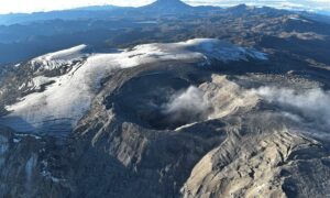
Fiji Archipelago / Kadavu Island : Nabukelevu :
Kadavu Provincial Administrator and officials warn nearby villages to avoid landslide areas of Mt Washington.
The Kadavu Provincial Administrator and his officials are on the ground advising nearby villages and communities to avoid the landslide areas of Mount Washington in Kadavu and refrain from going out diving until further advise is issued by the National Disaster Management Office.
This has been confirmed by the Acting Commissioner Eastern, Inoke Tuiwainunu.
NDMO says the continuous seismic activity experienced in Kadavu since Sunday is currently being monitored by NDMO, the Mineral Resources Department and the Commissioner Eastern Division officials through the Provincial Administrator Kadavu.
Fijivillage has also received on the ground reports of aftershocks being felt by villagers in the area up until this morning.
Acting Director NDMO, Litiana Bainimarama says the safety of villagers and communities nearby is paramount and they will work closely with the Mineral Resources Department to assess the situation on the ground.
Mineral Resources Department Principal Technical Officer, Sakaraia Vunisa confirms they have been receiving reports of explosion-like noises and tremors through the media but will have to verify whether its happening throughout the island of Kadavu or only within the vicinity of Mt Washington.
Vunisa says it is best to get the actual assessment before a way forward is explored.
The Eliki Memorial School management has decided to close the school as they can see dust from the mountain.
Eliki Memorial School Head Teacher, Josua Rasoki says he closed the school from Monday for safety precautions and also because of the water pipes for the school was damaged during the earthquake.
Rasoki says they have felt tremors up until 7 o’clock this morning and this is a risk for students as it is the closest school to the mountain.
https://www.facebook.com/fijivillage/videos/410183949667304/
The andesitic-to-dacitic Nabukelevu lava-dome complex occupies the SW end of Kadavu Island at the S end of the Fiji archipelago. The high point of the complex is Mt. Washington, an andesitic lava dome. Flat-lying dacitic lava flows are found at Cape Washington along the W coast and at Talaulia Bay on the NE coast. NNE-trending faults cut the complex in several locations and define its E boundary. The dome complex is cut by several collapse scarps, which were the source of debris avalanches that have incorporated human artifacts and remains. Debris avalanches have entered the sea on the both the N and S sides of the volcano. Onshore and offshore deposits as well as native legends indicate that several eruptions have occurred during the Holocene. Block-and-ash flows related to dome growth have occurred within the past few hundred years.
Source : Fidjivillages. GVP.
Video : Fidjivillages via Sherine France.
Lire l’article en entier : https://fijivillage.com/news/-Kadavu-Provincial-Administrator-and-officials-warn-nearby-villages-to-avoid-landslide-areas-of-Mt-Washington-kr25s9/
Photos : Kaiviti Diver.
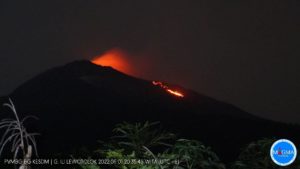
Kamchatka , Klyuchevskoy :
VOLCANO OBSERVATORY NOTICE FOR AVIATION (VONA).
Issued: October 24 , 2019
Volcano: Klyuchevskoy (CAVW #300260)
Current aviation colour code: ORANGE
Previous aviation colour code: yellow
Source: KVERT
Notice Number: 2019-163
Volcano Location: N 56 deg 3 min E 160 deg 38 min
Area: Kamchatka, Russia
Summit Elevation: 15580 ft (4750 m)
Volcanic Activity Summary:
A moderate gas-steam with some amount of ash activity of the volcano continues. According to video data, ash plume is extending for 40 km to the north-east of the volcano.
A moderate gas-steam with some amount of ash activity of the volcano continues. Ash explosions up to 16,400-23,000 ft (5-7 km) a.s.l. could occur at any time. Ongoing activity could affect low-flying aircraft.
Volcanic cloud height:
18040-19680 ft (5500-6000 m) AMSL Time and method of ash plume/cloud height determination: 20191024/0115Z – Video data
Other volcanic cloud information:
Distance of ash plume/cloud of the volcano: 25 mi (40 km)
Direction of drift of ash plume/cloud of the volcano: ENE / azimuth 60 deg
Time and method of ash plume/cloud determination: 20191024/0050Z – Himawari-8
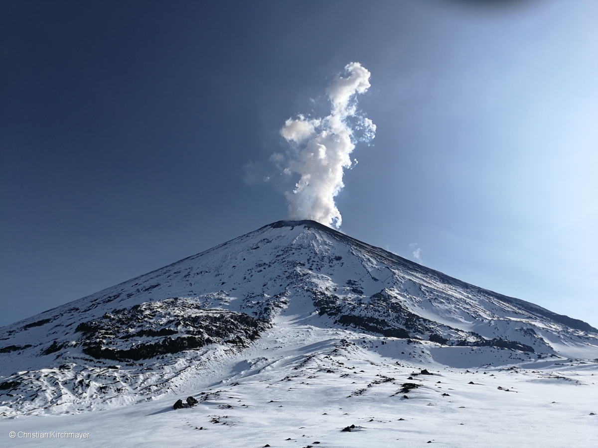
On October 24, on the Klyuchevskoy volcano, in Kamchatka, ash discharges were recorded. The volcano is assigned an « orange » code of danger for aviation, says the regional department responsible for the Ministry of Emergency Situations.
« The height of the ash column was 6,000 meters and that of the volcano itself, 4,750 meters, » says the report.
A plume of ash moves to the northeast. At present, no ash falls in settlements in Kamchatka territory have been recorded. However, as noted by the Ministry of Emergency Situations, in the event of a change of wind direction, the possibility that a small amount of ash falls on the villages of the Oust-Kamchatsky municipal area is not excluded.
Source : Kvert . eadaily.com/ru/
Photo : Christian Kirchmayer via Kvert .
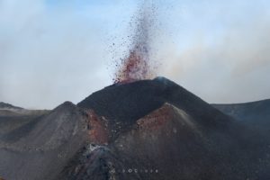
Chile , Nevados of Chillan :
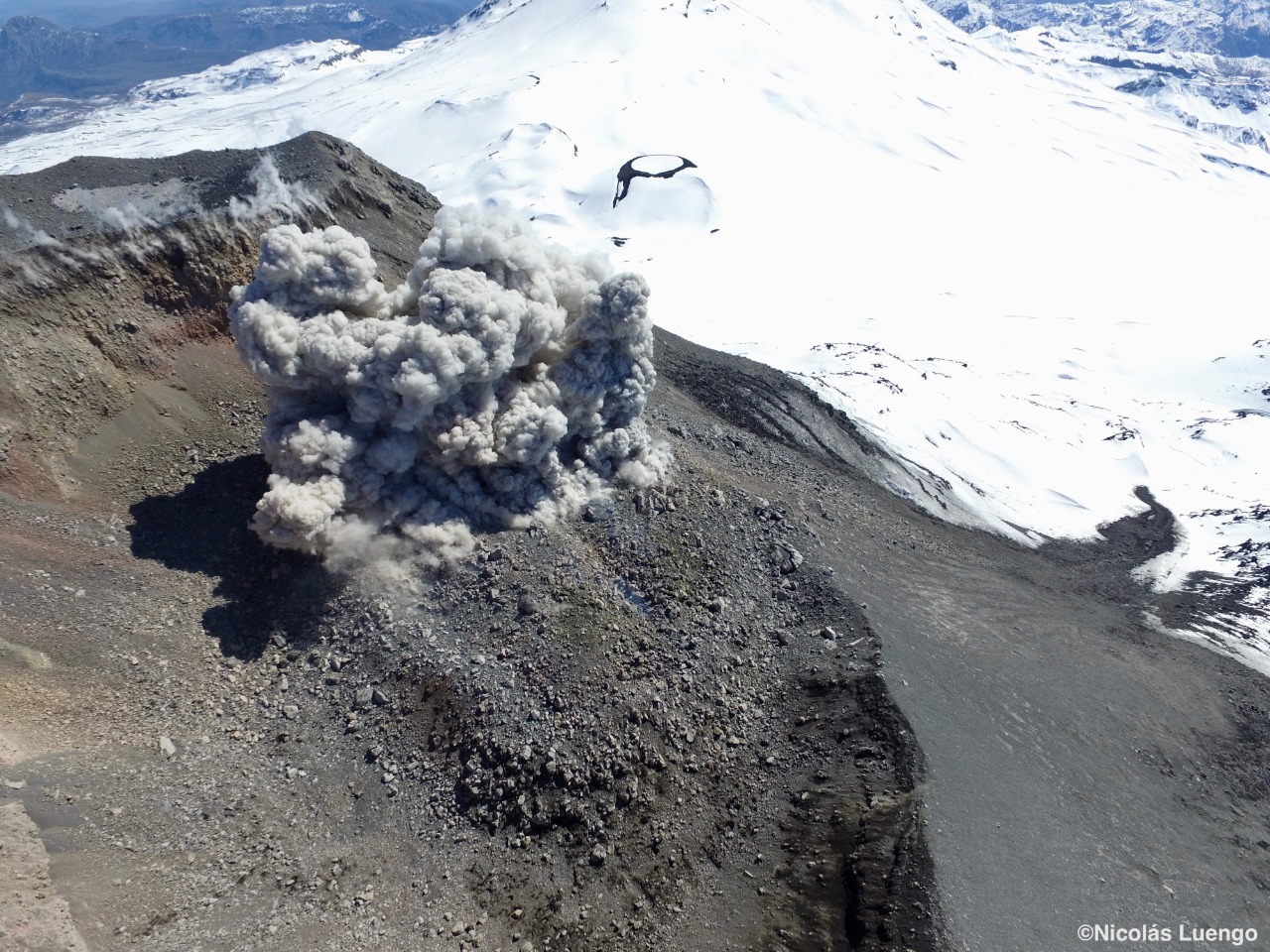
Special Volcanic Activity Report (REAV), region of the Nevados de Chillán volcanic complex, October 23, 2019 at 15:50 local time (mainland Chile).
The National Geological and Mining Service of Chile (Sernageomin) discloses the following PRELIMINARY information obtained from the monitoring equipment of the National Volcanic Monitoring Network (NVRN) processed and analyzed at the Volcanological Observatory of the South Andes (OVDAS) ):
Wednesday, October 23 at 15:35 local time (18:35 UTC), monitoring stations near the Nevados de Chillán volcanic complex recorded an explosion associated with an LP-type seismic signal with emission of gas and of materials. particulate.
The characteristics of the LP earthquake are as follows:
TIME OF ORIGIN: 15:35 local time (18:35 UTC)
LATITUDE: 36,856 ° S
LONGITUDE: 71,375 ° W
DEPTH: 1.6 km
REDUCED TRAVEL: 1282 cm2
ACOUSTIC SIGNAL: 109 Pascals (Pa) reduced to 1 km
OBSERVATIONS:
The gas and particulate matter emissions were mainly eastbound (E).
The volcanic technical alert is maintained at the ORANGE level.
Sernageomin monitors online and informs in a timely manner of possible changes in volcanic activity.
Source : Sernageomin .
Photo : Nicolas Luengo / Sernageomin .
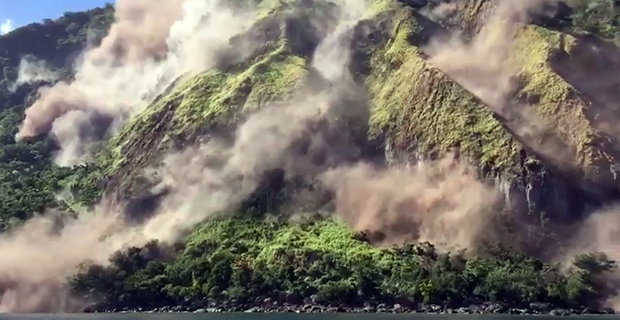
Guatemala , Santiaguito :
Volcano Special Bulletin
Updated by Jose Leonardo Quexel Hernandez on October 23, 2019 at 14:14 local time.
VOLCANO SANTIAGUITO.
LAHAR MODERE IN THE RAVINE OF RIO CABELLO DE ANGEL, TRIBUTARY TO RIO NIMA I.
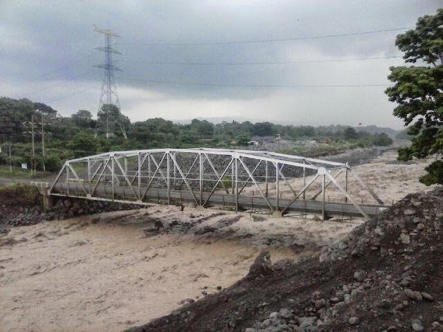
The heavy rains on the upper domes of the volcanic complex of Santiaguito generate a descent of moderate lahar in the ravine of Rio Cabello de Angel, tributary of the Nimá I river. This lahar has the following characteristics: 15 meters wide, accompanied by tree branches and volcanic materials such as ashes and blocks 1 to 2 meters in diameter that vibrate the ground. Trained material was deposited by constant eruptive activity.
Because of the rains in the volcanic zone, it is therefore not excluded that lahars can be generated in the next minutes in the rivers San Isidro and Tambor, tributaries of the Samala River.

Therefore, INSIVUMEH recommends:
At SE-CONRED: Take precautions as there is a possibility of lahars in all the main ravines and other canals nearby, so it is necessary to inform the population not to stay in or near the ravines .
Source : Insivumeh.
Photo : Unknown author.