
July 30 , 2019.
La Réunion , Piton de la Fournaise :
Activity Bulletin from Monday 29 July 2019 to 18:00 (local time).
Alert level: Alert 2-2
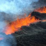
The eruption started on July 29, 2019 around 12:00 (local time) continues. The intensity of the eruptive tremor (a witness of the intensity of the eruption) has decreased by a factor of 2 since the beginning of the eruption (Figure 1).
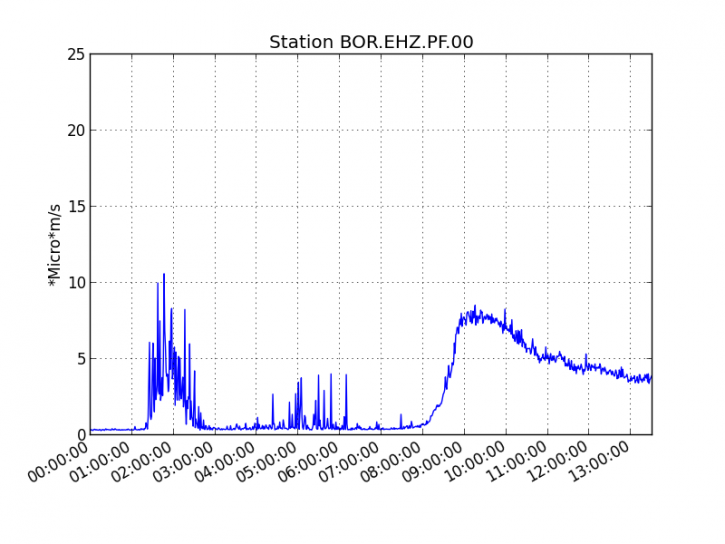
Figure 1: Evolution of the RSAM (indicator of the volcanic tremor and the intensity of the eruption) between 04h00 (00h00 UTC) and 17h75 (13h45 UTC) on July 29th, 2019 on the seismic station of BOR, located at the top of the volcano. (© OVPF-IPGP)
Three fissures opened on the northern flank of the volcano (600 m from the Formica Léo) over a total length of about 450 m, on the remains of the July 2018 flow.
The first observations, on site and by helicopter, of the OVPF teams always showed at 17h (local time) an activity on the three cracks with lava fountains of the order of 20-30m high and the flows of aa type lava extending for a short length (about 500 m) given the relatively flat topography.
A team from the OVPF went on site to conduct the first lava sampling.
The surface flows estimated from the satellite data via the HOTVOLC platform (OPGC – University of Auvergne), were of the order of 21.6 m3 / s at the beginning of eruption.
Activity Bulletin from Tuesday, July 30, 2019 at 05h45 (Local time)
The eruption started on 29/07/2019 around noon local time stopped today, the 30/07/2019 at 04:30 local time (00:30 UT), after a gradual fall of the volcanic tremor (Figure 1).
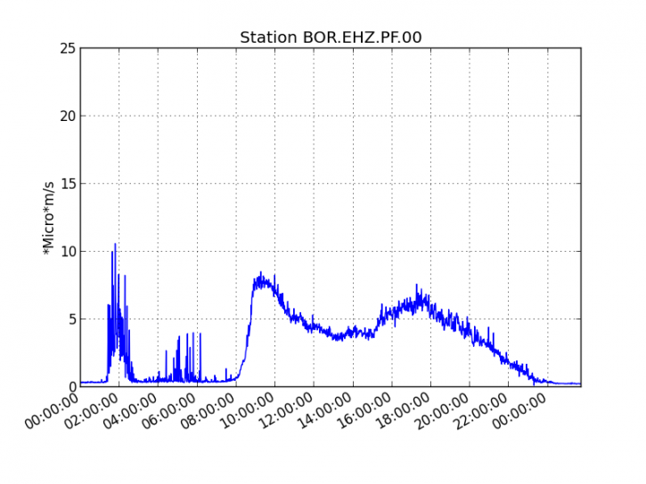
Figure 1: Evolution of the RSAM (indicator of the volcanic tremor and the intensity of the eruption) between 04h00 (00h00 UTC) on July 29th and 05h45 (01h45 UTC) on July 30th, 2019 on the seismic station of BOR, located at the top of the volcano. (© OVPF-IPGP)
No assumption is currently discounted as to the evolution of the future situation (final shutdown, resumption of activity on the same site, resumption of activity further downstream) given the short duration of eruption and low volumes emitted on the surface.
This eruption will not have lasted long, less than a day to be exact! Started around noon this Monday, July 29, 2019, the third eruption of the year Piton de la Fournaise is already over. It stopped around 4:30 in the morning on Tuesday, July 30, an information confirmed by the director of the volcanological observatory of Piton de la Fournaise (OVPF) Aline Peltier with Imaz Press Réunion. This time it was in the Enclos , on the north side, that the lava flowed from the Dolomieu. At least three eruptive cracks were observed on Monday at Rosemont Chapel.
Source : OVPF. IP Réunion.
Videoo : Imaz Press Réunion (Page officielle).
Italy , Stromboli :
PRESS RELEASE N ° 17 ACTIVITIES OF THE STROMBOLI VOLCANO, 20:00 (LOCAL TIME) on 28/07/2019.
Sunday, July 28, 2019
The activity of the Stromboli volcano is characterized by explosive activity generating abundant ash and scorias emissions from the C-SW crater and explosions rich in ash in crater located in the NE sector. The infrasonic pressures associated with this activity continue to remain at very high values (> 2 bar).
In this context, the number of VLP signals has been maintained since 26 July at very high values (> 25 events / hour) and the volcanic tremor is stable at oscillating values between medium and high.
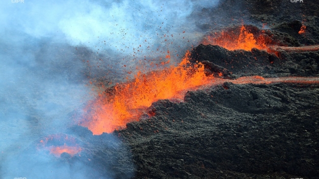
Explosive activity is associated with effusive activity from a mouth located at the west end of the southwestern sector of the current crater zone. From July 26, the effusive activity fed 2 lava flows with channels of a few tens of meters wide (Figure 1).
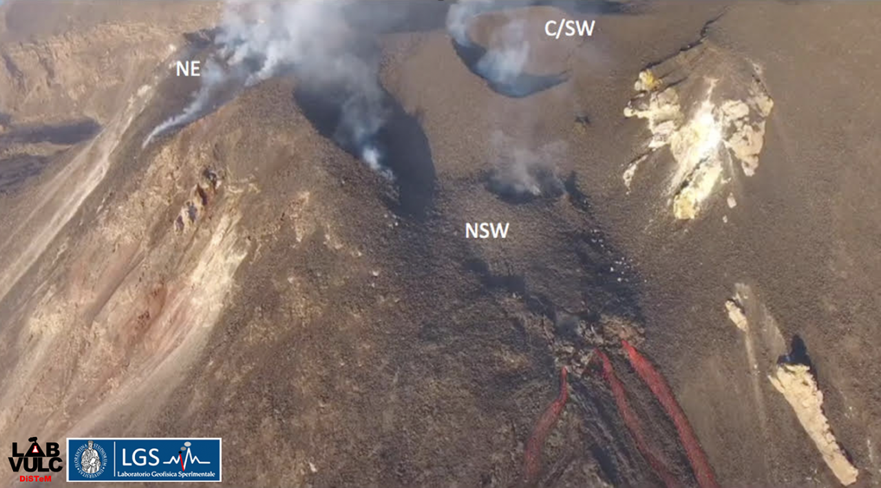
Figure 1. Image of the two lava flows under the crater terrace. Above, it is possible to observe the location of the eruptive vents inside the crater terrace. NE: northeast; C / SW: center-southwest; NSW: new crater southwest.
The Sentinel2 image, acquired on July 27 at 09:50 UTC (Figure 2), shows that the active edge of the current flow is in the upper part of the Sciara del Fuoco. In particular, images acquired on July 26. by drone, have shown how the products emitted by the effusive activity form a lava field inside the plateau, located at an altitude of about 600 m above sea level, below the locality from Fili di Baraona (Figure 3).
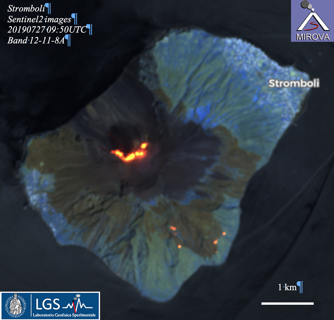
Figure 2. SENTINEL image of Stromboli volcano at 10:00 UTC on July 20, 2019 (MIROVA -UNITO). The ongoing fires are visible in the southeastern part of the island.
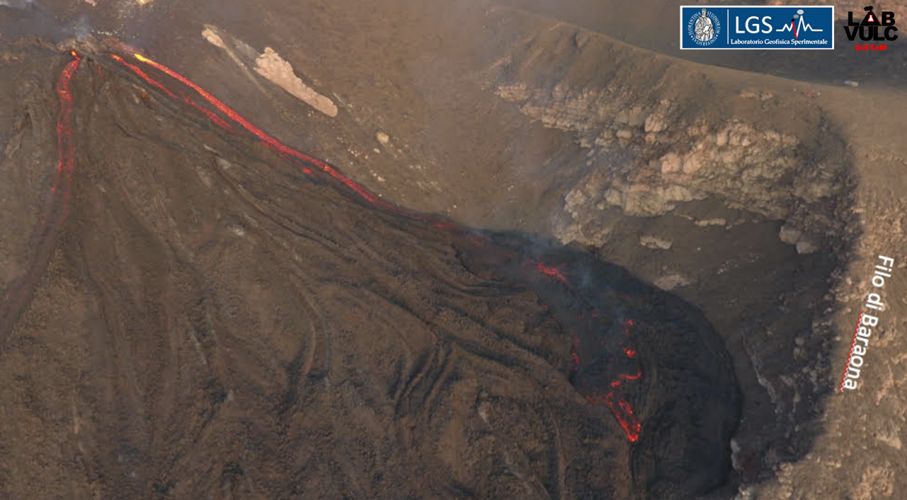
Figure 3. Image of the lava field formed as a result of effusive activity on the southwestern slope, which began on July 3rd.
The SO2 flux measured by the UV Roccette camera (Figure 4) shows the persistence of an upward trend at very high levels (very high reaching 304 t / d on July 27th), typical of effusive activity. The effusive degassing regime is confirmed by the low CO2 / SO2 ratios (between 3.3 and 5.1).
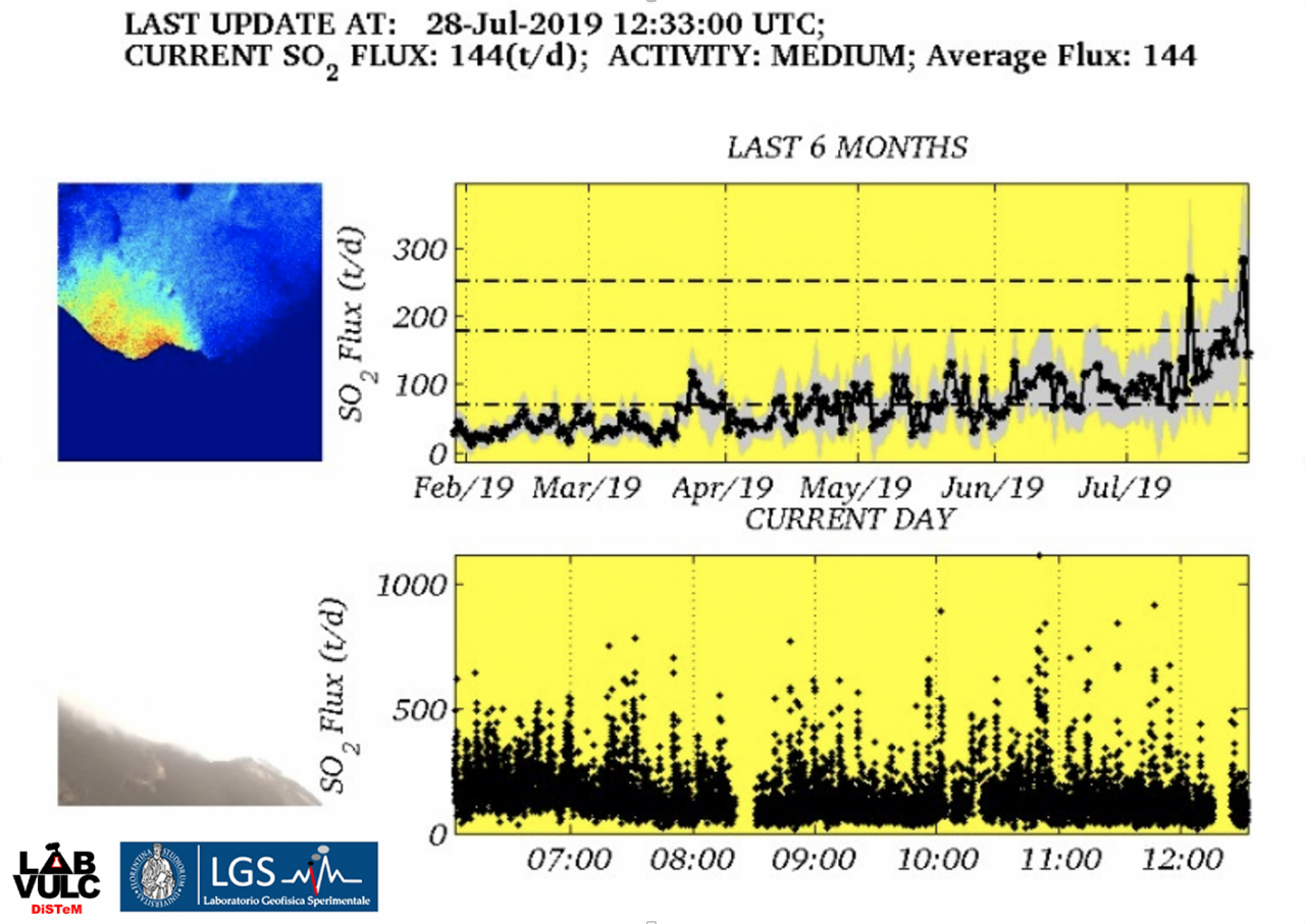
Figure 4. Trend of the SO2 flux evaluated by the Roccette UV chamber during the last 6 months and the last day.
The thermal activity of the MODIS satellite shows, in the images acquired with favorable geometry and weather conditions, a certain stability on the high values with average heat flows of 210 MW during the last week. These values are consistent with a current activity feed with rates of 0.6 to 1.2 m3 / s (Figure 5). On the basis of these data, about 3 Mm3 have been issued since July 3rd.
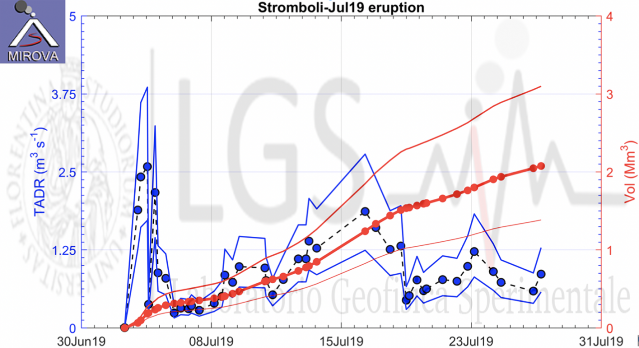
Figure 5. Trend of the mean effusion rate (average exit rate over time) and lava volumes released from July 4, 2019 (preliminary estimates extracted from MODIS-MIROVA data).
Source : lgs.geo.unifi.it.
Photo : Wolfgang Künker / Facebook.
Lire l’article : http://lgs.geo.unifi.it/index.php/blog/comunicato-stromboli-28-luglio-h2000
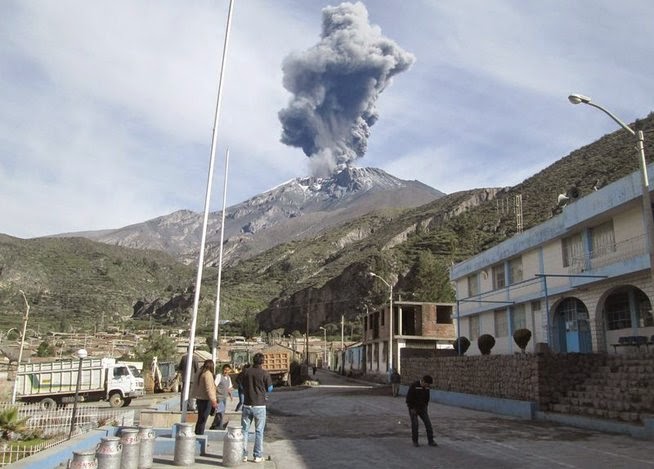
Peru , Ubinas :
VOLCANIC ACTIVITY REPORT, Update of July 29, 2019, 20h00.
Alert level: orange
The Geophysical Institute of Peru (IGP) reports that the Ubinas volcano has anomalies on various geophysical parameters, which are associated with the rise of the magma, the presence of a magmatic body in surface of the crater and the increase of the seismic energy (type LP and Hybrid). Those if are consistent with the scenario recorded before the explosion occurred yesterday at 23h25. Currently, it is planned the continuation of the activity, with the occurrence of explosions with the expulsion of fragments of rocks and ashes.
Last 6 hours:
Explosions: 0
Earthquakes: 174
Emissions of ashes: in the case of ash production, the latter will disperse to the East and North – East sectors of the volcano (Yunga, Chojata and Lloque districts), with moderate winds at 10km / h.
Deformation: Without.
Thermal anomalies: 0
Recommendations:
Keep the alert level in orange. Do not approach a radius of less than 15 km from the crater. In case of ash fall, cover your nose and mouth with damp cloths or masks. Keep the doors and windows of the houses closed.
Source : IGP
Photo : Auteur inconnu .
Kamchatka , Sheveluch :
56.64 N, 161.32 E;
Elevation 10768 ft (3283 m), the dome elevation ~8200 ft (2500 m)
Aviation Colour Code is ORANGE
Explosive-extrusive eruption of the volcano continues. Ash explosions up to 32,800-49,200 ft (10-15 km) a.s.l. could occur at any time. Ongoing activity could affect international and low-flying aircraft.
A growth of the lava dome continues, a strong fumarolic activity and an incandescence of the dome blocks and hot avalanches accompanies this process. Satellite data showed a thermal anomaly over the volcano all Week.
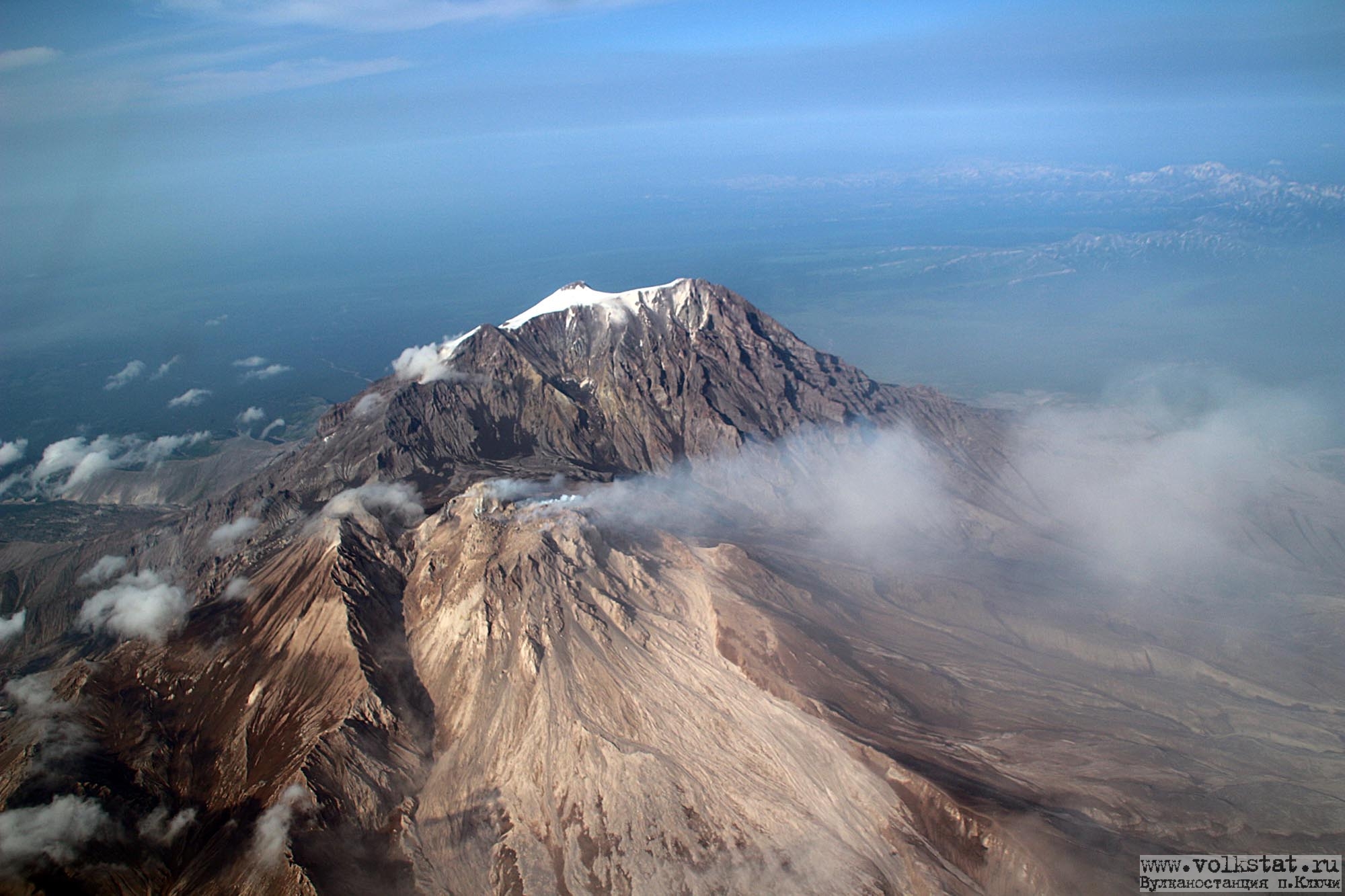
On July 16, employees of the Kamchatka Volcanic Station conducted an aerial survey of the Sheveluch volcano to examine the state of the active dome. The flight was made from an airplane and the picture was taken through the window pane. As a result, the quality of the photo is far from ideal.
The northeastern portion of the dome was partially covered with clouds. At the foot of the dome on the north side, an explosive crater has formed.
Source : Kvert , Volkstat ru. Yu Demyanchuck.
Photo : I. Borisov et V. Tsvetkov , Volkstat ru.
Indonesia , Tangkuban Parahu :
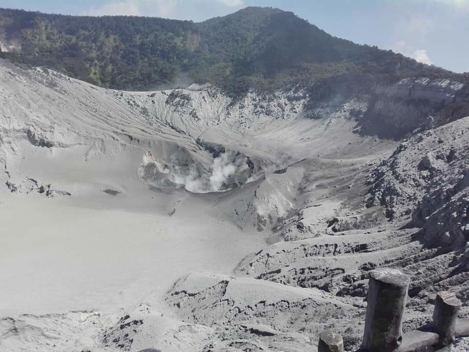
Level of activity at level I (normal) The activity of G. Tangkuban Parahu (2084 m altitude) began on 26 July 2019 at 15 h 48 min 18 s. The height of the ash column was observed at ± 200 m above the summit (± 2284 m above sea level). The ash column was observed thick, blackish-gray, leaning to the northeast and south. This eruption was recorded on a seismogram with a maximum amplitude of 50 mm (excluding scale) and a duration of ± 5 minutes 30 seconds.
Since yesterday and until this morning, the volcano is clearly visible. The smoke from the crater is white with a low intensity.
The seismographs, July 29, 2019 recorded:
88 earthquakes.
Tremor continuous amplitude 0.5 – 4 mm (dominant value 1 mm).
Recommendation:
Communities around Tangkuban Parahu, traders, tourists and mountaineers are not allowed to approach Ratu and Upas craters within 500 meters and are not allowed to stay in the active crater area. inside the volcanic complex.
Communities around the Tangkuban Parahu, traders, tourists, mountaineers and tourism officials must become aware of the increasing concentration of volcanic gas and not dwell on the lips of the active crater, in order to avoid a exposure to gas that could affect health and safety.
Communities around the Tangkuban Parahu, traders, tourists, mountaineers and tourism officials, should be alert to sudden phreatic eruptions and not preceded by obvious volcanic symptoms.
For the normal volcano status: people / tourists / mountaineers do not spend the night and do not camp in the crater to avoid the potential threat of toxic gases.
Source : PVMBG.
Photo : BNPB


No comment yet, add your voice below!