
July 09 , 2019.
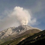
Peru , Sabancaya :
Period of analysis: from July 1st to July 7th, 2019. Arequipa, July 8, 2019.
Alert level: ORANGE
The Geophysical Institute of Peru (IGP) reports that the eruptive activity of the Sabancaya volcano remains moderate. Therefore, for the following days, no significant change is expected.
The analysis of records obtained from the seismic network of the Sabancaya volcano for the period from 1 to 7 July 2019 has identified the occurrence of about 2228 earthquakes of volcanic origin, the highest percentage being associated with the movements of magmatic fluids. During this week, an average of 23 daily explosions of low to medium intensity were recorded.
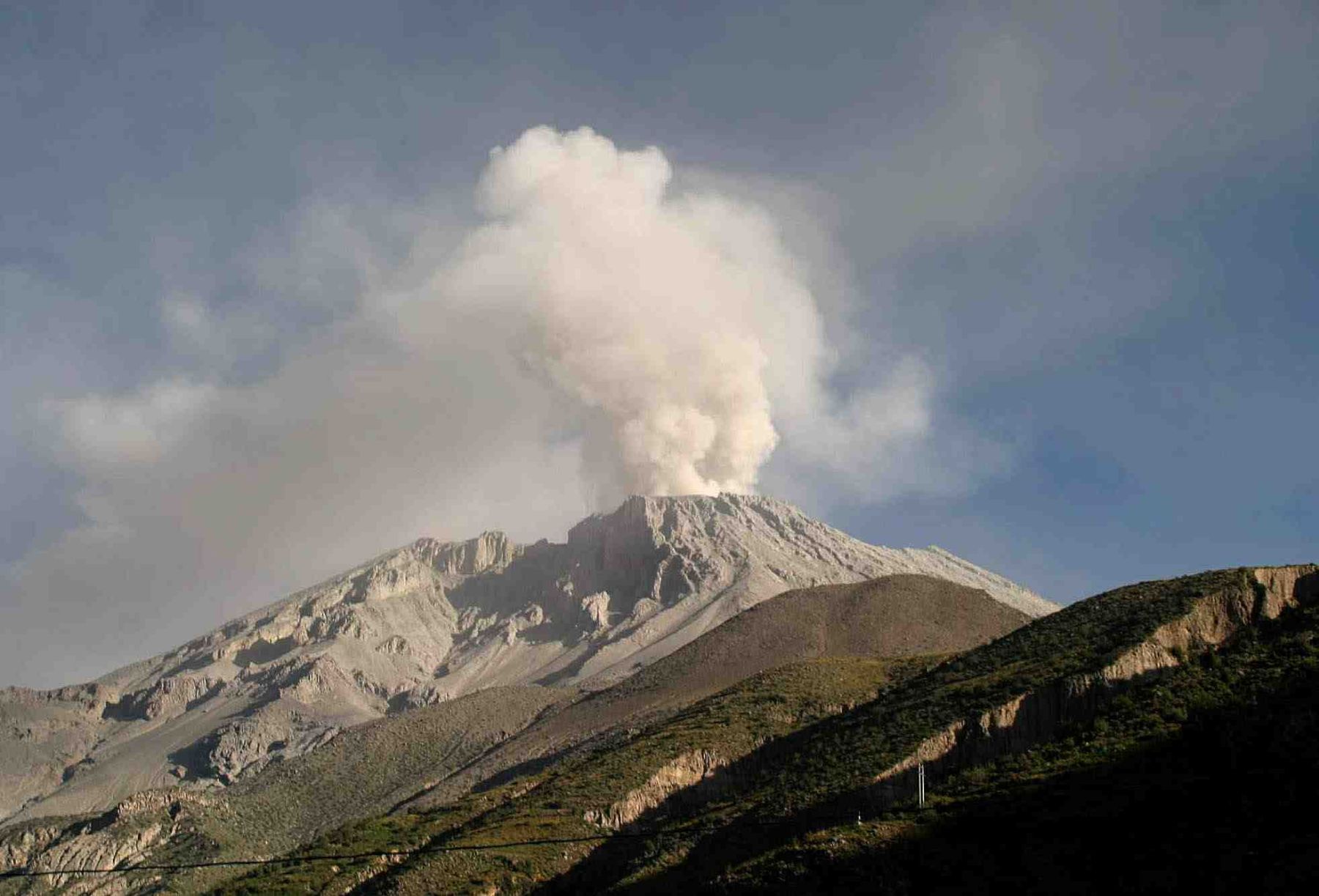
The monitoring of the deformation of the volcanic structure, using GNSS data (processed with fast orbits), presents no significant anomalies. Visual surveillance, using surveillance cameras, identified the appearance of columns of gas and ash up to 3.7 km high above the summit of the volcano (2 July 2019), including ashes were dispersed to the eastern, south-eastern and north-eastern sectors of Sabancaya (Colca Valley, Yura). Satellite monitoring revealed 13 thermal anomalies on the volcano from 1 MW to 23 MW, associated with the presence of a hot body near the surface and the occurrence of continuous explosions.
Source : IGP Pérou.
Photo : Auteur Inconnu.
Indonesia , Dukono :
VOLCANO OBSERVATORY NOTICE FOR AVIATION – VONA.
Issued: July 09 ,2019
Volcano: Dukono (268010)
Current Aviation Colour Code: ORANGE
Previous Aviation Colour Code: orange
Source: Dukono Volcano Observatory
Notice Number: 2019DUK46
Volcano Location: N 01 deg 41 min 35 sec E 127 deg 53 min 38 sec
Area: North Maluku, Indonesia
Summit Elevation: 3933 FT (1229 M)
Volcanic Activity Summary:
Eruption with volcanic ash cloud at 00h22 UTC (09h22 local)
Volcanic Cloud Height:
Best estimate of ash-cloud top is around 6493 FT (2029 M) above sea level, may be higher than what can be observed clearly. Source of height data: ground observer.
Other Volcanic Cloud Information:
Ash cloud moving to west
Remarks:
Eruption and ash emission is continuing
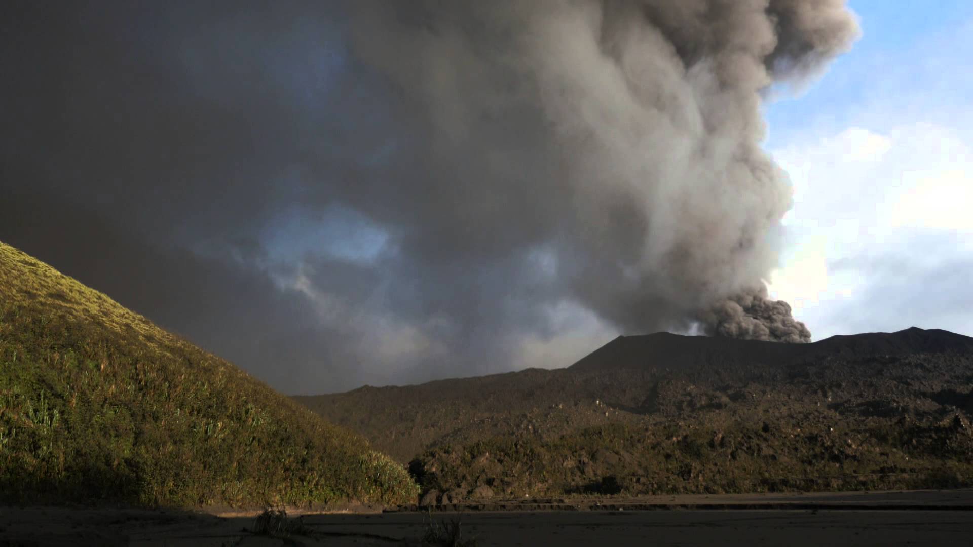
Level of activity at Level II (WASPADA). The Dukono volcano (1229 m above sea level) has continuous eruptions.
Since yesterday and until this morning, the volcanic peak was clear until it was covered with fog. The smoke from the main crater is white to gray with a height of 600 meters above the summit. The wind is blowing weakly to moderately from the West and North West.
The seismographs, July 8, 2019 recorded:
1 volcanic emission earthquake.
1 felt earthquake
2 distant tectonic earthquakes
Continuous tremor with amplitude 0.5 to 20 mm, dominant value of 10 mm
Recommendation:
People around G. Dukono and visitors / tourists should not climb and approach the crater of Malupang Warirang within a radius of 2 km.
Source : Magma Indonésie , PVMBG.
Photo : Auteur Inconnu.
Guatemala , Santiaguito :
VOLCANOLOGICAL SPECIAL BULLETIN BESAN N ° 48-2019
STRONG LAHAR IN SAN ISIDRO RIVER Guatemala June 8, 2019, 18:45 (local time)
Activity type: Peléenne
Morphology: Complex of dacitic domes
Geographical location: 14 ° 44 ’33 ˝ Latitude N; 91 ° 34’13˝ Longitude O.
Height: 2500msnm.
Because of the rains that occur in the areas of Santiaguito volcano, the seismic station STG8 records the descent of a strong lahar in the bed of the San Isidro River, tributary of the El Tambor River, which is in turn a tributary of the river Samalá.
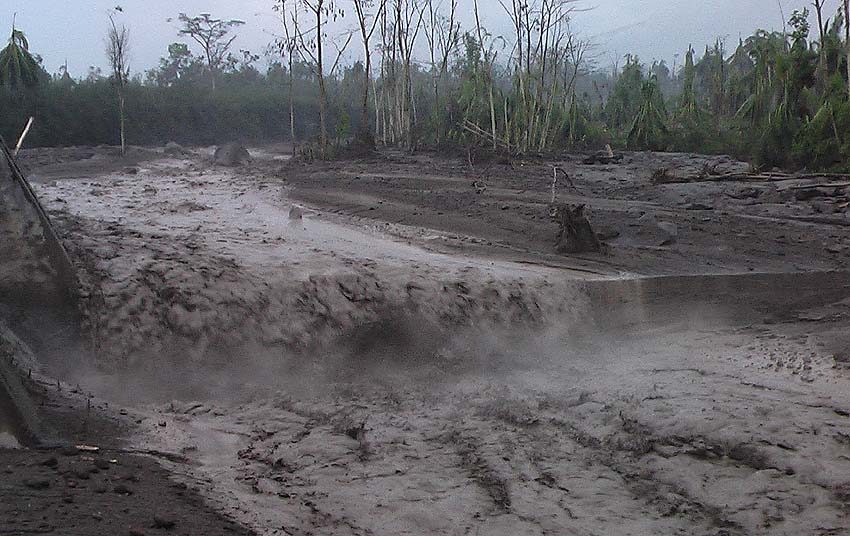
This lahar has the following characteristics: In its front part it carries tree trunks, shrubs and sediments of the banks of the river by which it advances, has dimensions of about 2 m high and 20-25 m of wide, drags blocks 2 and 3 m in diameter.
As the rains continued, the probability of generating lahars late at night and early in the morning through the channels of the Santiaguito volcano is not excluded.
Source : Insivumeh
Photo : Caroline Sarrazin , Rés-EAUx .
Mexico , Popocatepetl :
July 08, 11:00 am (July 08, 16:00 GMT)
In the last 24 hours, thanks to the surveillance systems of the Popocatépetl volcano, 165 exhalations have been identified, accompanied by water vapor, gas and light amounts of ash. In addition, 376 minutes of low amplitude tremor were recorded, four minor explosions, three yesterday at 10:06, 19:57, 21:57, the rest today at 09:47 and four major explosions recorded yesterday at 14:25 and 23:27, the other two today. at 01:24 and 03:55. During the night, a weak incandescence was observed during certain events.
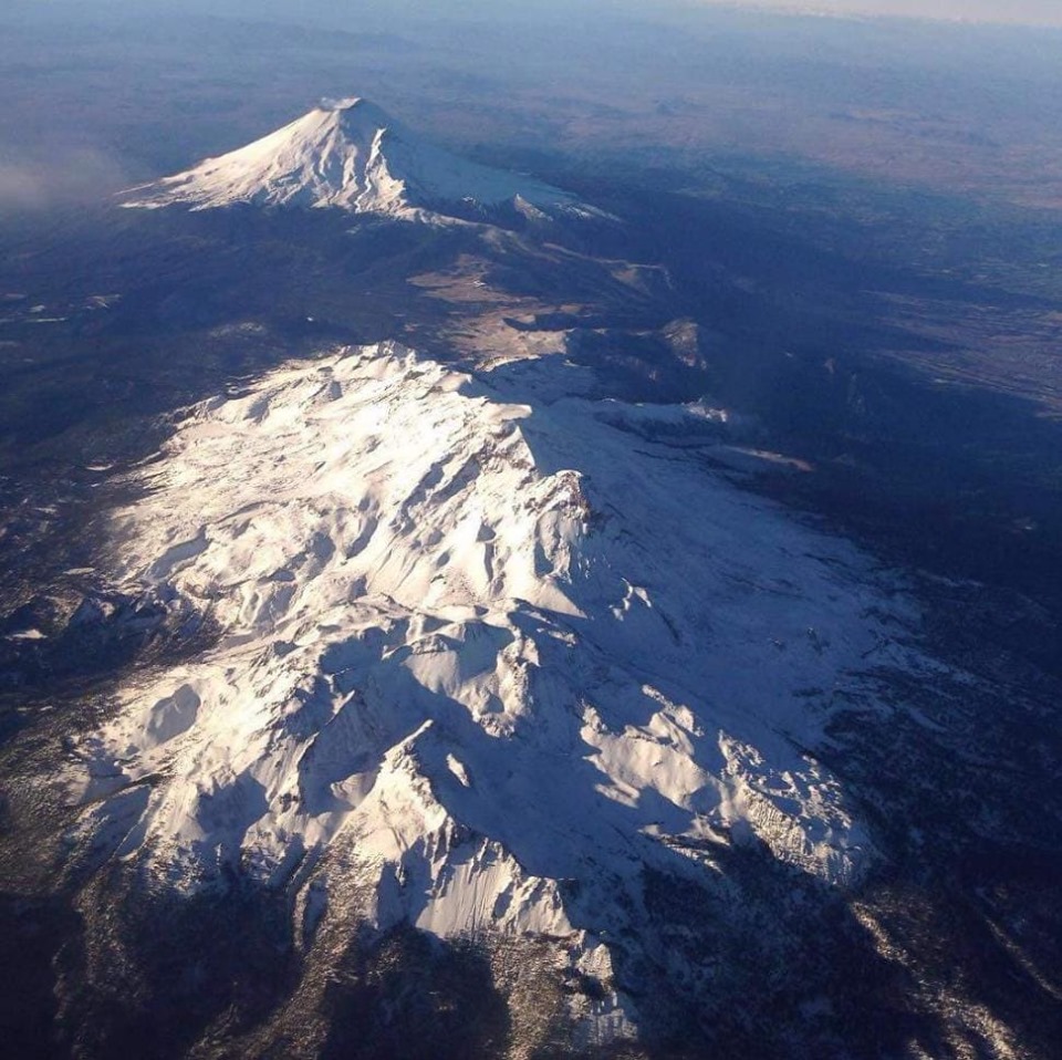
Popocatepetl and Iztacihuatl
Starting today in the morning and at the time of writing this report, we have observed exhalations containing water, gas and a low ash content, which the winds preferentially scatter to the East. -North West .
CENAPRED urges NOT to APPROACH the volcano and especially the crater, because of the risk of falling ballistic fragments, and in case of heavy rains, to move away from the bottom of the ravines because of the risk of mudslides and debris.
The Popocatepetl warning light is located at YELLOW PHASE 2.
Source : Cenapred .
Photo : Ulises Rosales .
La Guadeloupe , La Soufrière :
Monday, July 8, 2019 at 16:00.
Sequence of earthquakes in La Soufrière area of Guadeloupe – Basse Terre
The sequence of volcanic earthquakes that began on Friday, July 5, 2019 at 6:04 am local time (July 5, 2019 10h04 UTC time *) in the La Soufrière volcano area, continues with the recording of 139 earthquakes since its Inception.
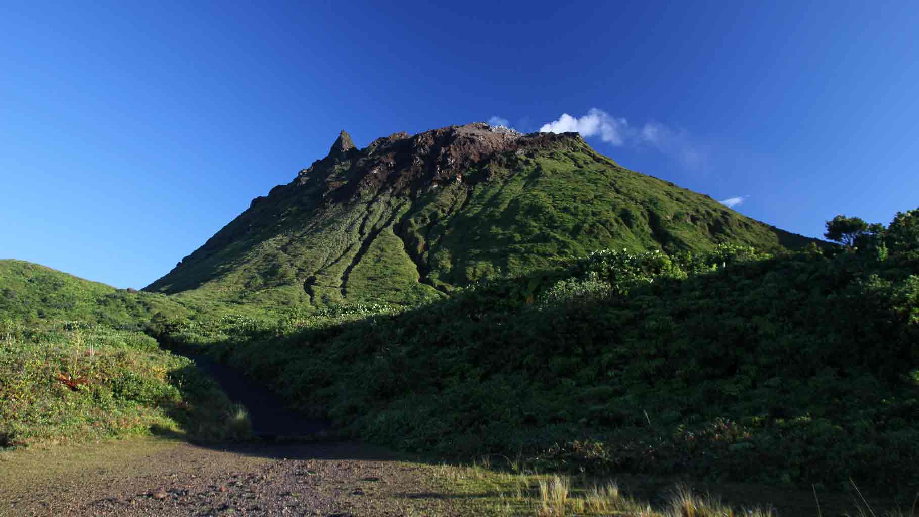
Earthquakes are of very small magnitude (M <1). No earthquakes were reported. The events are located at a depth of <2.5 km under the summit of the dome of La Soufrière.
The alert level remains: yellow, vigilance.
Source : Direction de l’OVSG-IPGP.
Photo : aide-voyage.com


No comment yet, add your voice below!