June 13 , 2019.
La Réunion , Piton de la Fournaise :
Activity Bulletin from Wednesday, June 12, 2019 at 14:30 (local time)
Alert level: Alert 2-2
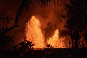
The eruption started on June 11, 2019 at 6:35 am (local time) continues. The intensity of the eruptive tremor (witnessing the intensity of the eruption) has remained at a relatively constant level for 24 hours (Figure 1).
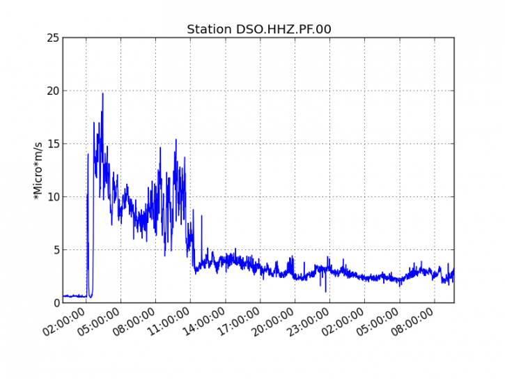
Figure 1: Evolution of the RSAM (indicator of the volcanic tremor and the intensity of the eruption) between 04:00 (00:00 UTC) on June 11, 2019 and 14:00 (10:00 UTC) on June 12, 2019 on the seismic station of DSO (© OVPF -IPGP). (IPGP / OVPF)
-Over the last 24 hours:
. No significant deformities were recorded.
. No volcano-tectonic earthquakes have been recorded.
. A decrease in SO2 fluxes was observed.
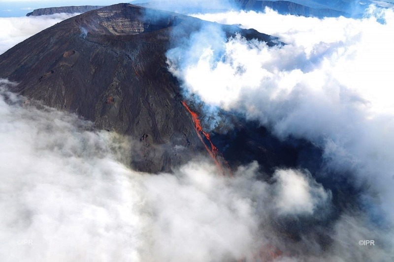
Yesterday, at 15:30 local time, only the lowest altitude crack was still active. Due to poor weather conditions, the casting front could not be observed by the on-site team.
The estimated surface flows from the satellite data, via the MIROVA HOTVOLC platform (OPGC – University of Auvergne), were between 7 and 27 m3 / s today.
The images of the OVPF webcam located in Piton des Cascades helped to locate the casting front this morning around 1200-1300 m altitude.
Source : OVPF.
Photo : Imazpress
Kamtchatka , Sheveluch :
VOLCANO OBSERVATORY NOTICE FOR AVIATION (VONA).
Issued: June 12 , 2019 .
Volcano:Sheveluch (CAVW #300270)
Current aviation colour code:ORANGE
Previous aviation colour code:orange
Source:KVERT
Notice Number:2019-98
Volcano Location:N 56 deg 38 min E 161 deg 18 min
Area:Kamchatka, Russia
Summit Elevation:10768.24 ft (3283 m), the dome elevation ~8200 ft (2500 m)
Volcanic Activity Summary:
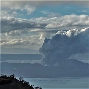
A growth of the lava dome continues. According to video data, a gas-steam plume containing some amount of ash on the height about 4.0 km a.s.l. continues to extend to west-northwest of the volcano. Ash cloud was reising up to 4.5 km a.s.l. from a hot avalanche which collapsed on the eastern flank of the lava dome at 05:23 UTC.
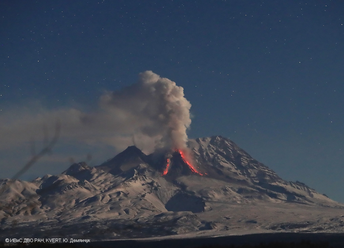
Explosive-extrusive eruption of the volcano continues. Ash explosions up to 32,800-49,200 ft (10-15 km) a.s.l. could occur at any time. Ongoing activity could affect international and low-flying aircraft.
Volcanic cloud height:
14760 ft (4500 m) AMSL Time and method of ash plume/cloud height determination: 20190612/0523Z – Video data
Other volcanic cloud information:
Distance of ash plume/cloud of the volcano: 9 mi (15 km)
Direction of drift of ash plume/cloud of the volcano: WNW
Time and method of ash plume/cloud determination: 20190612/0535Z – Video data
Source : Kvert.
Photo : Yu. Demyanchuk. IVS FEB RAS, KVERT.
Kamchatka , Klyuchevskoy :
VOLCANO OBSERVATORY NOTICE FOR AVIATION (VONA).
Issued: June 12 , 2019
Volcano:Klyuchevskoy (CAVW #300260)
Current aviation colour code:ORANGE
Previous aviation colour code:orange
Source:KVERT
Notice Number:2019-99
Volcano Location:N 56 deg 3 min E 160 deg 38 min
Area:Kamchatka, Russia
Summit Elevation:15580 ft (4750 m)

Volcanic Activity Summary:
The explosive eruption of the volcano continues. According to video data, ash explosions up to 6 km a.s.l. , plume extend to the west-northwest of the volcano.
The explosive eruption of the volcano continues. Ash explosions up to 16,400-23,000 ft (5-7 km) a.s.l. could occur at any time. Ongoing activity could affect low-flying aircraft.
Volcanic cloud height:
19680 ft (6000 m) AMSL Time and method of ash plume/cloud height determination: 20190612/2150Z – Video data
Other volcanic cloud information:
Distance of ash plume/cloud of the volcano: 3 mi (5 km)
Direction of drift of ash plume/cloud of the volcano: WNW
Source : Kvert
Photo : 22/4/2019 , A. Klimova
Italy / Aeolian Islands , Stromboli :
38.789°N, 15.213°E
Elevation 924 m
INGV reported that during 3 and 6-9 June activity at Stromboli was characterized by ongoing Strombolian explosions and degassing from multiple vents within the crater terrace. Explosions from two vents (N1 and N2) in Area N (north crater area, NCA) occurred at a rate of 1-4 per hour, ejecting material 80 m high and producing ash plumes.
Explosions from two vents (S1 and S2) in Area C-S (South Central crater area) occurred at a rate of 3-8 per hour, ejecting material 80-150 m high. Gas plumes rose from vent C.

Spectacular incandescent nighttime explosions at this volcano have long attracted visitors to the « Lighthouse of the Mediterranean. » Stromboli, the NE-most of the Aeolian Islands, has lent its name to the frequent mild explosive activity that has characterized its eruptions throughout much of historical time. The small island is the emergent summit of a volcano that grew in two main eruptive cycles, the last of which formed the western portion of the island. The Neostromboli eruptive period from about 13,000 to 5000 years ago was followed by formation of the modern edifice. The active summit vents are located at the head of the Sciara del Fuoco, a prominent horseshoe-shaped scarp formed about 5000 years ago as a result of the most recent of a series of slope failures that extend to below sea level. The modern volcano has been constructed within this scarp, which funnels pyroclastic ejecta and lava flows to the NW. Essentially continuous mild strombolian explosions, sometimes accompanied by lava flows, have been recorded for more than a millennium.
Source: Section de Catane – Osservatorio Etneo (INGV), GVP.
Vidéo : Kevin Fauchère.
Photo : G Vitton.
Indonesia , Agung :
Information on G. Agung’s eruption, June 13, 2019
An eruption of Mount Agung, Bali, occurred on 13 June 2019 at 17h38, but the height of the ash column was not observed. This eruption is recorded on a seismogram of maximum amplitude of 30 mm and a duration of ± 3 minutes 53 seconds.
– The eruption column was not observed from the Rendang observation post because it was covered with fog.
-There were projections of incandescent materials in all directions at a distance of about 700 m
Currently, G. Agung is at Level III (SIAGA) with recommendations:
(1) The communities around Mount Agung and mountaineers / visitors / tourists must not climb or carry out any activity in the estimated danger zone, ie in all areas within 4 km radius of Mount Crater. Agung. The estimated risk area is dynamic and continues to be evaluated. It can be modified at any time to follow the latest observation data from Mount Agung.
(2) Communities that reside and move around the rivers flowing from Gunung Agung should be aware of potential secondary hazards in the form of lahars that may occur especially during the rainy season and if the eruptive material is always deposited in the area of the summit.
VOLCANO OBSERVATORY NOTICE FOR AVIATION – VONA.
Issued : June 12 , 2019 .
Volcano: Agung (264020)
Current Aviation Colour Code: ORANGE
Previous Aviation Colour Code: orange
Source: Agung Volcano Observatory
Notice Number: 2019AGU27
Volcano Location: S 08 deg 20 min 31 sec E 115 deg 30 min 29 sec
Area: Bali, Indonesia
Summit Elevation: 10054 FT (3142 M)
Volcanic Activity Summary:
Eruption with as cloud at 17h38 (01h38 local)
Volcanic Cloud Height:
Ash-cloud is not visible
Other Volcanic Cloud Information:
cannot observed
Remarks:
Seismic activity is characterized by Vulcano Earthquake
Source : PVMBG , Magma Indonésie .
Photo : Suryana Arimbawa