Décember 03 , 2018.
Alaska , Semisopochnoi :
51°55’44 » N 179°35’52 » E,
Summit Elevation 2625 ft (800 m)
Current Volcano Alert Level: ADVISORY
Current Aviation Color Code: YELLOW
Unrest continues at Semisopochnoi volcano. A small explosion from Semisopochnoi at 11:44 UTC (02:44 AKST) was recorded by regional infrasound sensors in Adak. No eruptive activity was observed in mostly clear satellite views before or after the detected explosion. Additional explosions are still possible and will likely occur without warning. Local seismic data remains offline.
Semisopochnoi is monitored with an on-island seismic network, though this is currently off-line, and remotely by satellite and lightning sensors. Furthermore, an infrasound array on Adak Island may detect explosive emissions from Semisopochnoi with a 13 minute delay if atmospheric conditions permit.
Source : AVO
Colombia , Galeras :
The level of activity of the volcano continues at the level: YELLOW LEVEL ■ (III): CHANGES IN THE BEHAVIOR OF THE VOLCANIC ACTIVITY.
Following the activity of the VOLCÁN GALERAS, the COLOMBIAN GEOLOGICAL SERVICE (SGC) informs that:
For the period from November 20 to November 26, 2018 and compared to the previous week, the seismicity of the Galeras volcano decreased compared to the previous week, with the predominance of VT type earthquakes (volcano-tectonic earthquakes, associated with fractures of the cortical material inside the volcano). These events were located scattered at depths between 2.5 and 10.5 km and local magnitudes less than M2.6 on the Richter scale.

During the week under review, we observed white gas emissions, low pressure, low height and variable direction due to wind action.
The other geophysical and geochemical parameters of Galeras volcano monitoring did not show any significant variations.
The COLOMBIAN GEOLOGICAL SERVICE is attentive to the evolution of the volcanic phenomenon and will continue to inform in a timely manner of the observed changes.
Source : SGC
Photo : Capra.
Mexico , Popocatepetl :
During the last 24 hours, thanks to the monitoring systems of the Popocatepetl volcano, 51 exhalations were identified, accompanied by water vapor and gas, as well as 3 minutes of harmonic tremor.
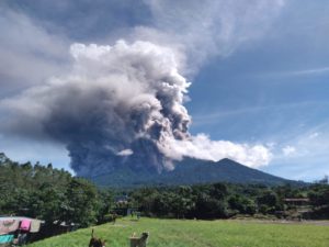
This morning, two explosions ejected incandescent fragments on the high slopes of the volcano and generated ash columns reaching a height of 2.5 km, which the wind dispersed to the northeast. The first occurred at 5:09 and the second at 9:22.
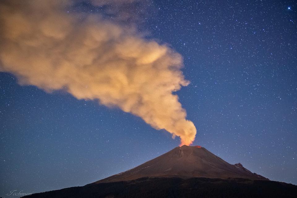
At the time of this report, the volcano is observed, with a constant emission of water vapor and gas directed towards the North-East.
CENAPRED insists that the volcano and especially the crater should not be approached, because they may cause the fall of ballistic fragments and, in case of heavy rains, to move away from the bottoms of ravines because of the danger of landslides and mudslides.
The Popocatepetl volcanic warning light is located at Amarillo Phase
Source : Cenapred.
Photo : Erik Gómez Tochimani Fotógrafo
Guatemala , Pacaya :
Type of activity: Strombolian
Morphology: Composite Stratovolcano.
Geographical location: 14 ° 22’50˝ Latitude N; 90 ° 36’00˝ Longitude O.
Height: 2,552msnm.
Weather conditions: Clear weather
Wind: North
Precipitation: 0.5 mm
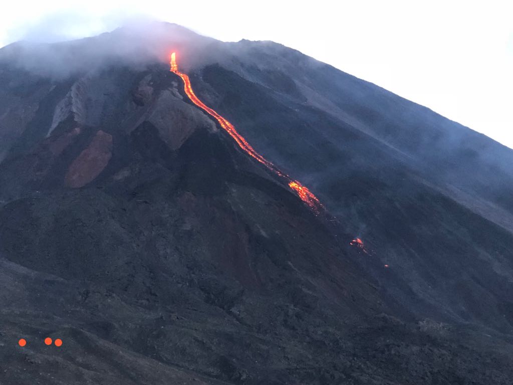
Activity:
Presence of low white fumaroles at an approximate elevation of 2,700 meters (8,858 feet) which are dispersed by wind in a northerly direction. The seismic station records the internal tremors associated with degassing and constant Strombolian explosions. These lift materials at a height of approximately 5 to 15 meters above the crater. There is an incandescent in the Mackenney crater and 2 lava flows towards the northwest, with lengths of 200 and 250 m. There are moderate avalanches on the lava flow fronts.
Source : Insivumeh
Photo : tn8.tv
Indonesia , Anak Krakatau :
VOLCANO OBSERVATORY NOTICE FOR AVIATION – VONA.
Issued: December 03 , 2018 .
Volcano: Anak Krakatau (262000)
Current Aviation Colour Code: ORANGE
Previous Aviation Colour Code: orange
Source: Anak Krakatau Volcano Observatory
Notice Number: 2018KRA92
Volcano Location: S 06 deg 06 min 07 sec E 105 deg 25 min 23 sec
Area: Lampung, Indonesia
Summit Elevation: 1082 FT (338 M)
Volcanic Activity Summary:
Eruption with ash clouds at 01.16 UTC (08.16 local time). The eruption lasted for 69 seconds. Eruption and ash emission is continuing.
Volcanic Cloud Height:
Best estimate of ash-cloud top is around 3322 FT (1038 M) above sea level, may be higher than what can be observed clearly. Source of height data: ground observer.
Other Volcanic Cloud Information:
Ash-cloud moving to north
Remarks:
Eruption recorded on seismogram with maximum amplitude 58 mm and maximum duration 69 second.
Activity of Anak Krakatau: This week, the vulcanian type activity is still observed at night in the form of glow and emission of incandescent materials in all directions, at a height of 200 m above the summit. The eruptions are accompanied by lava flows on the southern slope towards the sea. The eruption was also accompanied by weak to loud detonations at PGA Post in Pasauran-Banten. During the day, the mountain is often covered with fog, although the thick column of ash black rust reaches a maximum height of 100 to 700 m from the summit. The seismograph recorded 154 earthquakes of eruption, 45 earthquakes of emission, 60 shallow volcanic earthquakes, 80 deep volcanic earthquakes, 57 harmonic tremor and a continuous tremor of amplitude of 1 to 58 mm.
Source : Magma Indonésie, PVMBG.
Vidéo : Yohannes Tyas Galih Jati / Volcanodiscovery.