October 24 , 2018.
Iceland , Bárðarbunga :
Strong earthquake swarm under the Bárðarbunga volcano at midnight.
A powerful swarm of earthquakes struck Bárðarbunga volcano on Monday. Two distinct earthquakes of M4 +, including an earthquake of magnitude M4.6, and an earthquake of more than M3 on the Richter scale struck successively around midnight. The epicentres of all the earthquakes were in the eastern part of the caldera, at a significant depth.
According to the seismic monitoring system of the Icelandic Meteorological Office, an earthquake of magnitude M2.8 was detected at 23:34 at a depth of 4.1 km, followed by a second earthquake of magnitude M2.7, 17 seconds more late at a depth of 2.5 km. Nine minutes after midnight, an M4 magnitude earthquake was detected at a depth of 1.1 km (0.7 mi). At the same time, a second M4.6 magnitude earthquake was detected closer to the center of the caldera, at a depth of 7.1 km (4.4 mi). These were followed by a third earthquake with a magnitude of M3.5 and a depth of 2.2 km (1.4 mi).

Geophysicists believe the activity in Bárðarbunga is caused by magma being thrust from the earth’s mantle up into the magma chambers beneath the volcano’s caldera. The volcano has been showing increasing levels of activity for the past year or so, following the 2014-15 Holuhraun eruption at the northern edge of the system.
Source : Icelandmag.
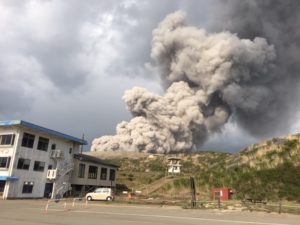
Japan , Kuchinoerabu-jima :
Yakushima – The Kuchinoerabu-jima volcano in Yakushima (Kagoshima) has a strong volcanic activity and a series of small eruptions over the past few days, said the Japanese Meteorological Agency (JMA) and is on alert.
The first eruption since 2015 was recorded Sunday night (21) and forced the JMA to raise the alert level to 3, prohibiting local residents or visitors from approaching the volcano.
According to information published by the broadcaster NHK, the agency warns against the possibility of projection of volcanic rocks and pyroclastic flow at a distance of up to 2 kilometers from the crater Shindake.
The eruption recorded around 18:30 Sunday generated a column of smoke of 100 meters. The eruption continued between 9 pm Sunday and 2 pm on Monday (22). At around 3:20 pm on Monday, another small eruption was recorded, raising a 500-meter column of smoke.
The volcano records intense seismic activity and strong release of volcanic gases. However, the sensors that identify the ground movements did not show any unusual activity.
The island is constantly monitored by the JMA and if there are new records that may indicate a possible stronger eruption, the agency can initiate the retreat activities of the inhabitants.
According to the Japan Meteorological Agency, which made an observation from the sky on the 22nd, there was no noticeable change in the topography around the Shin-yodake crater and no trace of volcanic ash compared to the observation of ‘August. However, following infrared thermographic observations, an abnormally high temperature was confirmed near crater and western slope cracks, and a smell of volcanic gas was also felt.
When the Shintake volcano exploded on May 29, 2015, the plume rose 9,000 meters above sea level, the highest level of warning « 5 » was issued for the first time in the history of observation. All the inhabitants escaped from the island. The volcanic earthquake rose sharply in August of this year, when volcanic gas emissions / day were observed at 1600 tons, but the alert level was reduced to « 4 » and then to « 3 » after about two weeks.
Volcanic activity is expected to continue in the future, the Japanese Meteorological Agency said, « activation could accelerate faster than at the time of the 2015 explosion
Source : alternativa.co.jp , hazardlab.jp .
Photo : 日本語: 海上保安庁
Colombia , Nevado del Ruiz :
Subject: Activity bulletin of the Nevado del Ruiz volcano.
The level of activity continues at the level: Yellow activity level or (III): Changes in the behavior of volcanic activity.
With regard to monitoring the activity of the Nevado del Ruiz volcano, the COLOMBIAN GEOLOGICAL SERVICE announces that:
During the past week, the seismicity caused by the fracturing of the rocks that make up the volcano has resulted in an increase in the number of earthquakes and a similar level of released seismic energy compared to the previous week. On 21 October, this seismicity increased south-west of the Arenas crater at depths between 3.8 and 4.5 km. Other active sources of the week were the East – Northeast, Northeast, Southeast and Arenas craters at depths of between 1.0 and 4.5 km. The maximum magnitude recorded during the week was 1.3 ML (local magnitude), corresponding to the earthquake recorded on October 22 at 09:23 (local time), located 4.1 km east-northeast, at 5.4 km deep. During the past week, the appearance of five episodes of low-energy, short-lived drumbeat seismicity, recorded on October 18, 21 and 22, is highlighted. This type of seismicity is related to the process of rising domes towards the surface.
(lava dome: viscous lava mound located on the emission channel of a volcano The rate of growth of the domes can vary from a few hours to several days, years or hundreds of years and can reach volumes of several tens from meters to several cubic kilometers).

Seismicity related to fluid dynamics, within the channels of the volcanic structure, showed a similar level of earthquake numbers and released seismic energy compared to the previous week.
This activity was characterized by the presence of earthquakes with variable energy levels of long period (LP), very long period (VLP) and tremors. The earthquakes were mainly located in the crater Arenas and its surroundings.
Volcanic deformations measured from electronic inclinometers, GNSS (Global Navigation Satellite System) stations and radar images have so far shown stability behavior without recording significant deformation processes of the volcanic structure.
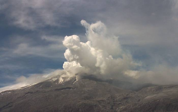
The volcano continues to emit into the atmosphere water vapor, ashes and gases, among which is the sulfur dioxide (SO2), as evidenced by the values obtained by the SCANDOAS stations installed in the volcano region and the analysis of satellite images. During the week, the NASA FIRMS portal reported several thermal anomalies of very low energy.
The column of gas, steam and ash reached a maximum height of 1400 m, measured at the top of the volcano on 19 and 22 October.
The Nevado del Ruiz volcano remains at the level of yellow activity.
Source : SGC
Photos : SGC , Inconnu.
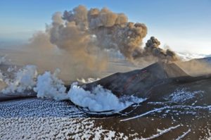
La Réunion , Piton de la Fournaise :
Activity Bulletin from Tuesday, October 23, 2018 at 3:45 pm (local time).
The eruption started on September 15th at 4:25 am local time continues. The intensity of the volcanic tremor (indicator of the eruptive intensity on the surface) is very slightly decreasing for several days.
– No volcano-tectonic earthquake was recorded during the day of 22 October, nor during the current day.
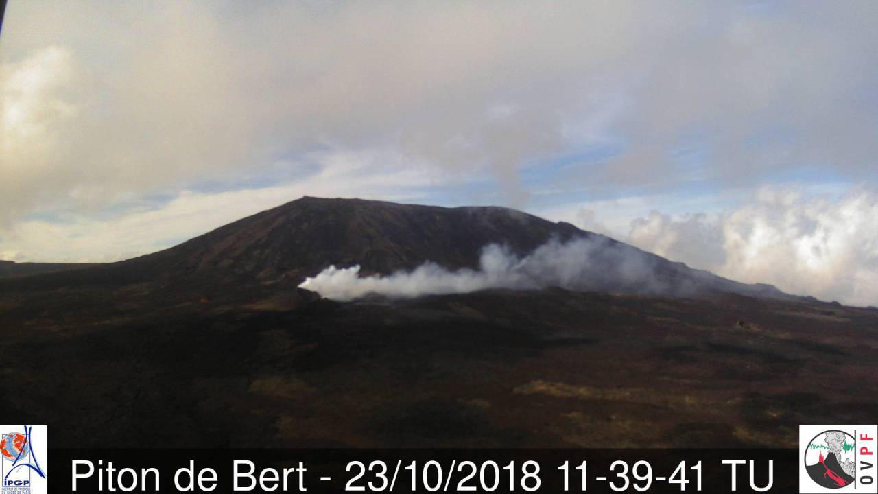
– Inflation (swelling) of the building is always recorded. This inflation reflects the pressurization of a localized source beneath the summit craters (Bory-Dolomieu) at a depth of 1-1.5 km, related to the recharge of the superficial reservoir by deeper magma.
– The surface flows could not be estimated today because of lava flows that are too weak at the surface and / or cloud cover.
Alert level: Alert 2-2 – Eruption in the Enclos.
Source : OVPF . http://www.ipgp.fr/fr/ovpf/bulletin-dactivite-mardi-23-octobre-2018-a-15h45-heure-locale
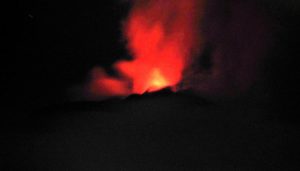
Indonesia , Sangeang Api :
8.2°S, 119.07°E
Elevation 1949 m
Based on a VONA from PVMBG an ash emission from Sangeang Api was generated at 13h38 on 15 October; it rose 250 m above the summit and drifted SW, W, and NW. The VONA noted that the ash emission possibly rose higher than what a ground observer had estimated. Seismic data was dominated by signals indicating emissions as well as local tectonic earthquakes. The Aviation Color Code was changed from Yellow to Orange.
Drone video showing the ongoing activity of rarely visited Sangeang Api volcano in Indonesia. Flights made on Sept. 30. 2018, from a camp in 1,5km distance to the crater.
Eruption details filmed in minimum distance to the lava dome, risking a drone loss inside the impact zone.
Note from 3:35, the gas pulsations output. Nice example of « train locomotive » also dear to the Fuego volcano.
Source: Pusat Vulkanologi dan Mitigasi Bencana Geologi (PVMBG, également connu sous le nom de CVGHM).
Video : Martin Rietze ( par drone)