May 05 , 2019.
Sorry for yesterday, internet Failure.
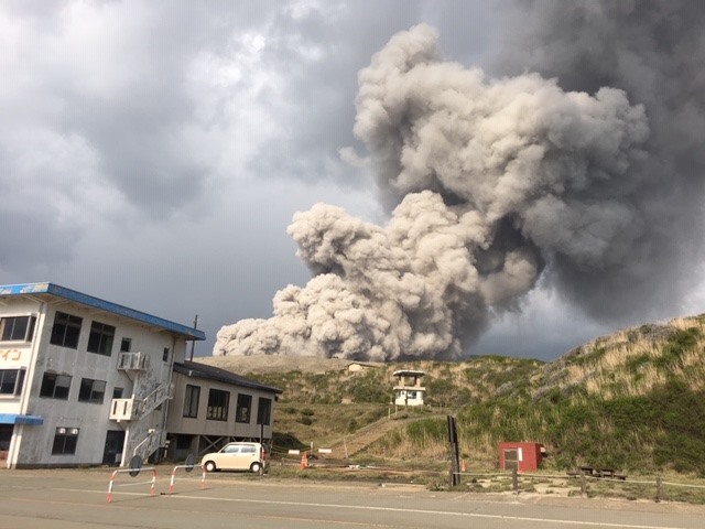
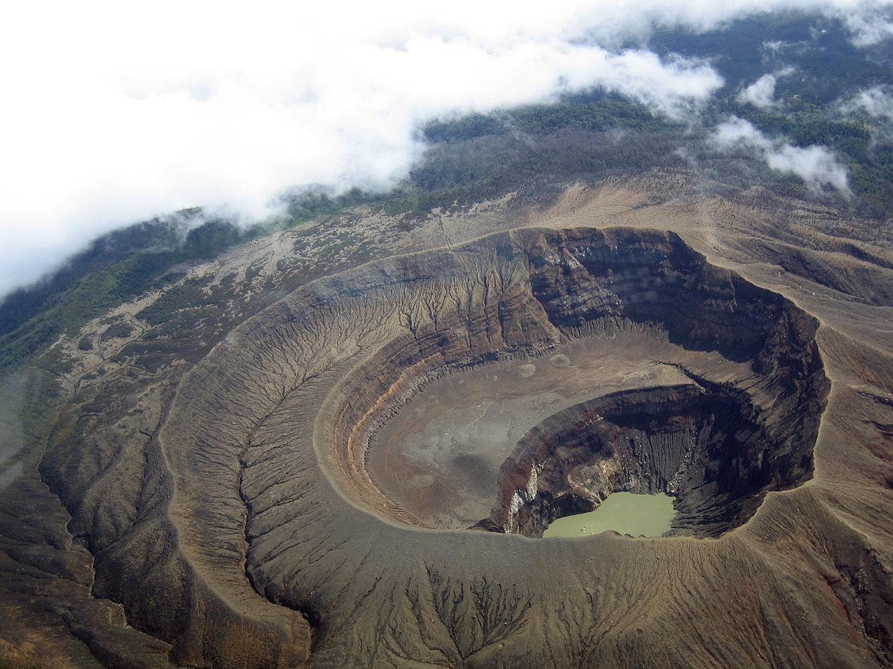
Japan , Asosan :
Status of volcanic activity:
On the crater of Nakadake, a very small eruption occurred on May 02 at 15:40. The vapors reached 600 m above the edge of the crater. The eruption phase began on April 19th.
According to the field survey, emissions of volcanic gas (sulfur dioxide) continue to be very high at 3,200 tonnes per day.
In the Nakadake Daiichi crater, we observed low fires with a high-sensitivity surveillance camera, on the night of 2 May until today morning.
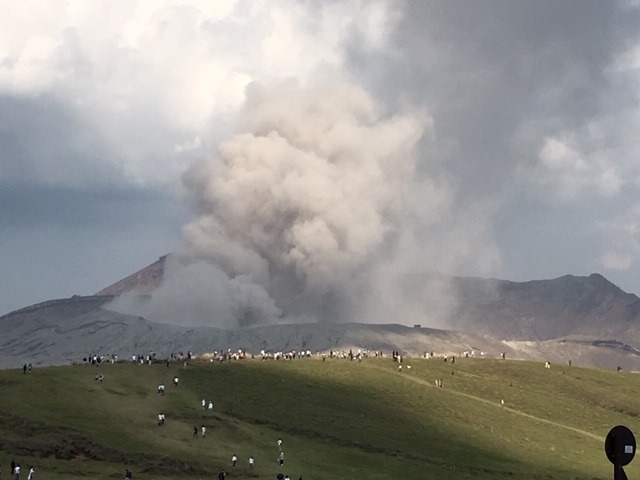
According to the extremely sensitive camera provided by the museum of Aso volcano, in the crater Nakadake Daiichi, there is a red glow; part of the bottom of the crater is red at night.
The amplitude of the volcanic tremors has passed into a more important state.
There are many isolated earthquakes and volcanic earthquakes.
In continuous observation with GNSS stations, a slight tendency to elongation is observed at the Kusensen Baseline. A magma chamber is assumed to be located in the deep part.
As volcanic activity is increasing, it is possible that an eruption affects a distance of about 1 km around the first crater of Nakadake.
Attention, disaster prevention is paramount.
At about 1 km from the first crater of Nakadake, pay attention to the large clasts and pyroclastic flows that drag and disperse the ballistic fragments that accompany the eruption.
In the wind, know that not only volcanic ash, but also small ashes can be blown away by the wind. Also pay attention to volcanic gas.
Do not enter dangerous areas in accordance with local government instructions, etc.
Source : Data JMA.
Photos : Aso Unesco Global Geopark
El Salvador , Santa Ana (Ilamatepec) :
Location: shared by the departments of Santa Ana and Sonsonate
Altitude: 2381 meters above sea level.
Type of volcano: Stratovolcano
Activity type: Vulcanian – Strombolian
Last eruption: October 1, 2005.
The seismic vibration of the volcano fluctuated between 28 and 32 RSAM units on average per day, ie in the normal range. The San Blas seismic station recorded 39 earthquakes related to the movement of fluids in the volcanic system. Regarding earthquakes associated with breakage of solid material, fourteen events (14) were recorded and only 11 (eleven) were located on the northwest and southeast flanks of the volcano crater. a depth of 9 km and with a maximum magnitude of M 2.3. None were reported as felt by the inhabitants of the region.
Emissions of sulfur dioxide (SO2) have fluctuated between 286 and 448 tonnes per day, with an average of 354 tonnes. These values are values near the baseline (<300 tonnes / day) and typical of a volcanic system with constant gas emission. MARN’s guard resources visiting the crater do not report a change in activity. The changes recorded through the instruments and the visits made indicate that the volcano presents a normal activity like any active volcano.
Source : Marn .
Photo : USAF.C-130.3 , 10/2018.
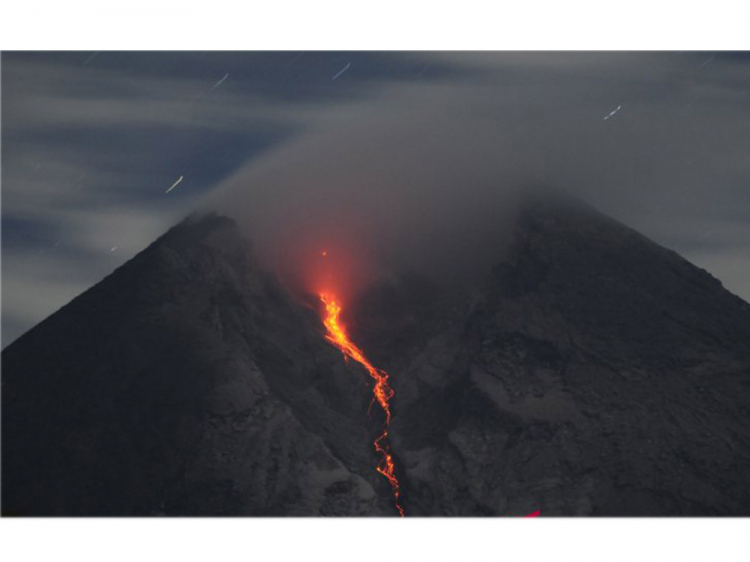
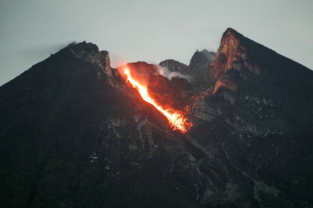
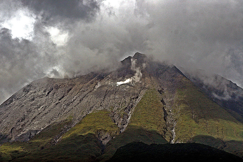
Indonesia , Merapi :
Mount Merapi Activity Report from April 26 to May 2, 2019
I. RESULTS OF OBSERVATION
Visual:
The weather around Mount Merapi is usually sunny in the morning while the afternoon until the night is cloudy and foggy. There is a white smoke of degassing, thin to thick with low pressure. The maximum smoke height of 150 m was observed from the Mount Merapi observation post in Kaliurang on May 1, 2019 at 0514 WIB.
The morphological analysis of the crater area based on photographs of the Southeast sector revealed no significant morphological changes. The volume of the lava dome is based on an aerial photography analysis with a drone made on April 9, 2019 with 466,000 m3. Since January 2019, the volume of the lava dome has been relatively constant due to the fact that most magma extrusions flow directly into the upper parts of Kali Gendol as avalanches and hot clouds.
Within a week, there were two avalanche clouds with a maximum slip distance of 850 meters upstream from Kali Gendol.
Seismicity:
This week, the seismicity of Mount Merapi recorded:
2 earthquakes of hot clouds (AP),
24 earthquakes (DG),
1 deep volcanic earthquake (VTA),
8 shallow volcanic earthquakes (VTB),
38 multiple phase earthquakes (MP),
186 avalanche earthquakes (RF),
21 low frequency earthquakes (FL)
2 tectonic earthquakes (TT).
The intensity of tremor this week was higher than last week.
Deformation:
The deformation of Mount Merapi, monitored by EDM and GPS this week, showed no significant change.
Rain and lahars:
This week, it was raining around Mount Merapi with a rainfall intensity of 34 mm / hour for 195 minutes, measured at the Mount Merapi observation post in Babadan on April 28, 2019. No cases of lahars were reported. or additional flows in rivers originating from G Merapi.
II. CONCLUSION AND ADVICE
Conclusion
Based on the results of the visual and instrumental observations, it was concluded that:
1. The lava dome is currently in a stable state with a relatively low growth rate.
2. The volcanic activity of Mount Merapi is still quite high and is at the activity level « WASPADA ».
Source : BPPTKG
Photo : Antara Foto/ Aloysius Jarot Nugroho , Avril 2019 . Antara/Hendra Nurdiyansyah , Mars 2019 .
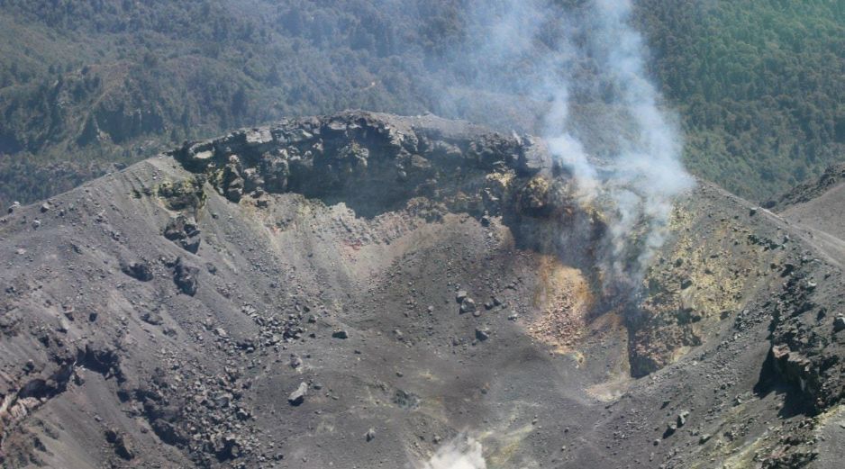
Mexico , Fuego de Colima :
Weekly technical bulletin on the activity of the Colima volcano
Date: 03-May-2019 Newsletter n ° 119
Seismic activity:
Last week, 324 high-frequency (HF) events, 8 long-period (LP) events, 5 landslides and 35.7 min of low-amplitude tremors were automatically recorded. On the April 26 seismogram at the SOMA station located 1.7 km from the crater of the volcano, there has been a considerable increase in earthquakes of high frequency (HF) or volcano-tectonic (VT) type. The largest events have been located, many of them have a depth of between 3,000 and 500 meters in the northern and northeastern parts of the volcanic building. Their magnitudes are between 2.4 and 3 Mc.

Visual observations:
During the period under review, steam and gas emissions were observed only in the eastern part of the crater. A flight with an unmanned aerial vehicle (UAV) was also carried out in the crater of the volcano on April 30th. No morphological changes were observed inside the crater compared to the last flight. The thermal camera recorded no anomalies related to possible changes in the external volcanic activity.
Geochemistry:
No measurements of SO2 flow during the week were made.
Remote perception:
No thermal anomalies detected by the MIROVA satellite system were observed during the last week.
Diagnostic:
Last week, the volcano continued with moderate internal seismic activity, without this resulting in an increase in surface volcanic activity. This had been observed in previous years before explosions and / or the growth of a new dome. The staff in charge of monitoring the volcano is attentive to possible changes and changes in activity.
Possible scenarios from days to weeks:
1. Moderate explosion and / or series of explosions.
2. There is new growth of lava dome at the top with collapses of incandescent material and lava flows.
Source : RESCO-CUEV-Faculté des sciences Université de Colima.
Photos : Radio Nacional , El Informador ( mai 2019) .
Philippines , Bulusan :
BULUSAN VOLCANO BULLETIN 05 May 2019 11:10 A.M.
This serves as a notice for the raising of Bulusan Volcano’s status from Alert Level 0 (normal) to Alert Level 1 (abnormal).
From 4 May 2019 to 5 May 2019, there was an increase in seismic activity of Bulusan Volcano. A total of sixteen (16) volcanic earthquakes were recorded by the Bulusan Volcano seismic monitoring network. Tilt data from 29 April 2019 to 5 May 2019 indicated slight inflation of the upper slopes. There is also a notable increase in water temperature of the monitored hot springs while wispy to weak emission of white steam plumes was observed from the southeast vents.
In view of the above activities, PHIVOLCS is now raising the Alert Level status of Bulusan Volcano from Alert Level 0 to Alert Level 1 (abnormal). This indicates that hydrothermal processes may be underway beneath the volcano that may lead to steam-driven eruptions. The local government units and the public are reminded that entry into the 4-kilometer radius Permanent Danger Zone (PDZ) should be avoided. Vigilance in the Extended Danger Zone (EDZ) on the southern slopes of Bulusan Volcano stretching two kilometers further downslope of the PDZ must be exercised due to the possibilities of sudden and hazardous phreatic eruptions, rockfall, and landslide. Civil aviation authorities must also advise pilots to avoid flying close to the volcano’s summit as ash from any sudden phreatic eruption can be hazardous to aircraft. Furthermore, people living within valleys and along river/stream channels should be vigilant against sediment-laden stream flows and lahars in the event of heavy and prolonged rainfall.
DOST-PHIVOLCS is closely monitoring Bulusan Volcano’s condition and any new development will be relayed to all concerned.
Source : Phivolcs.
Photo : Auteur inconnu , juillet 2015.
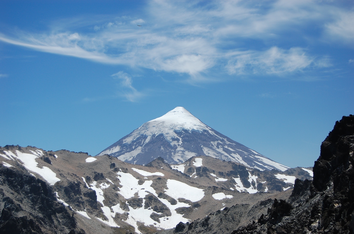
Chile, Lanin :
Special Report on Volcanic Activity (REAV), Auracania Region, Lanin Volcano, 04 May 2019, 23:50 Local Time (Mainland Chile).
The National Geological and Mining Service of Chile (Sernageomin) publishes the following PRELIMINARY information, obtained through monitoring equipment of the National Volcanic Monitoring Network (NVRN), processed and analyzed at the Volcanological Observatory of the Southern Andes (OVDAS) :
Yesterday, Saturday 04 May 2019 at 23:11 local time (03:11 UTC), monitoring stations installed near the volcano Lanin recorded an earthquake, associated with a process of fracturing rocks (volcano-tectonic type). This event was located 6.6 km north-northeast of the main crater.
The characteristics of the event, after its analysis, are as follows:
TIME OF ORIGIN: 23h11 (GMT -4)
LATITUDE: -39.588 ° S
LONGITUDE: 71.458 ° W
DEPTH: 8.8 KM
LOCAL MAGNITUDE: 3.0 (ML)
OBSERVATIONS:
At the time of this report, smaller replicas were not observed. The communities around the volcano reported that they had felt the event. In addition, the images obtained with the fixed camera show no superficial anomaly from the northern flanks of Lanin Volcano.
The level of volcanic technical alert remains at the level: Green.
Sernageomin continues online monitoring and will inform in a timely manner about any changes observed.
Source : Sernageomin.
Photo : Tierras Patagónicas