July 27 , 2018.
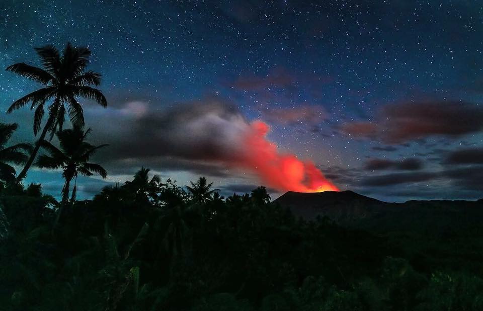
Vanuatu , Ambae :
VANUATU VOLCANO ALERT BULLETIN N°7 – AMBAE ACTIVITY , Saturday July 21st 2018
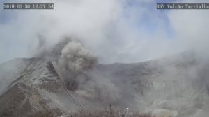
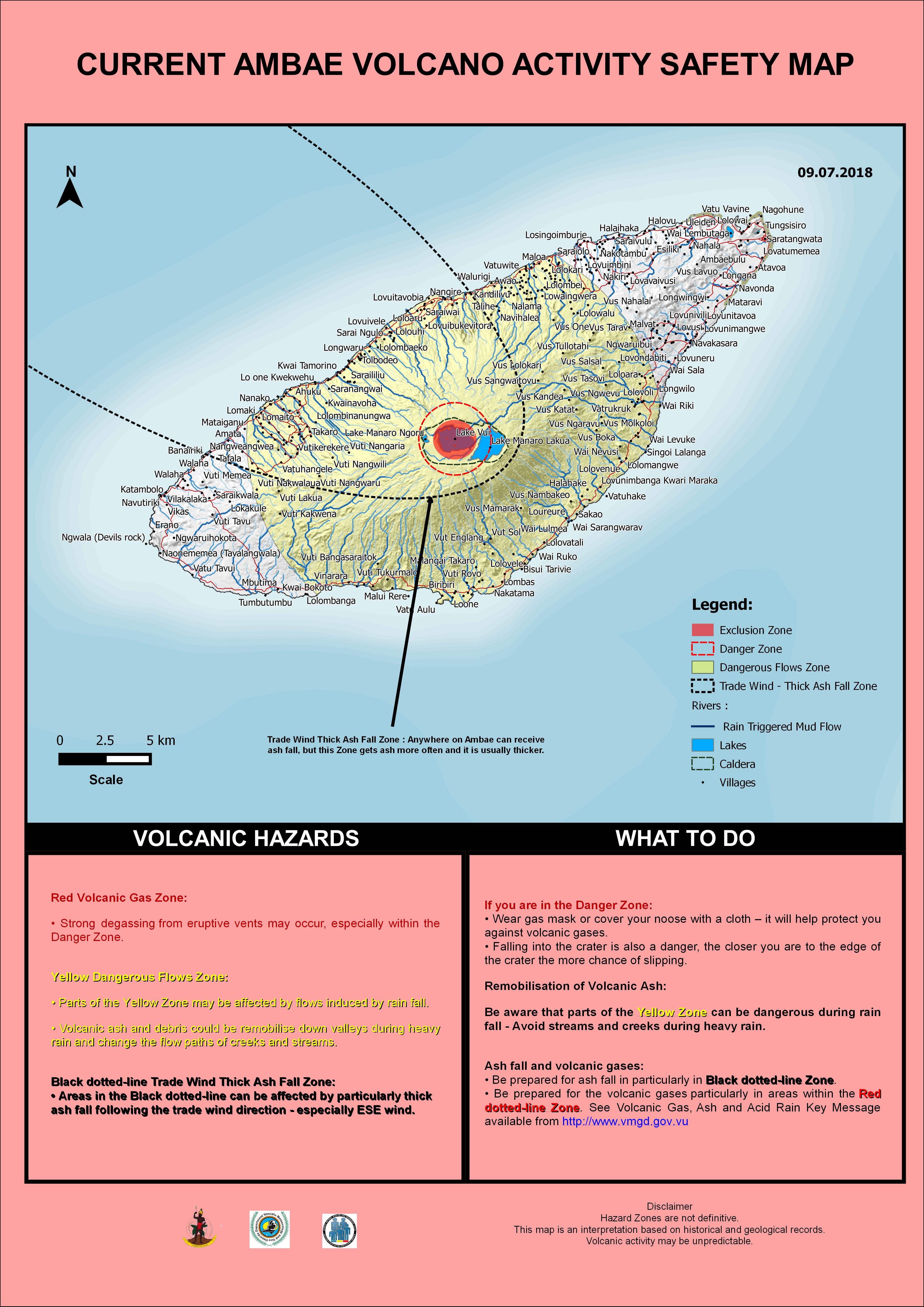
Ambae volcano is in the minor eruption state. The Volcanic Alert Level is raised to Level 3 .
The volcanic eruption at Ambae confined inside the Lake Voui is consistent with the Volcanic Alert Level 3. Scientific analyses confirm that the current activity is similar to the volcanic activity of March 2018 with more and sustained emissions of volcanic ashes. The possibility of imminent increasing activity is low. The Danger Zone for life safety is now limited at 3 km radius from the active vent and areas located in the Yellow Zone (See Map below).
Observations flights on 13th and 20th July 2018 confirm the activity at the volcano is only occurring in one of the summit crater lakes (Lake Voui) and is not changing. Photographs taken during observation flights show the activity consists of explosions and ejection of hot rocks from the eruptive vents accompanied by ash emission. A small –scale eruption continues in Lake Voui.
The presence of ash that has fallen on Ambae during the last eruptive phases and now will continue to change the behaviour of streams and creeks when it rains. The creeks and streams can produce floods and carry a lot more debris (sands, gravel and boulders). The flow path of streams and creeks could change due to the flood debris. Landslide may occur at some areas during heavy rain fall.
These observations and the analysis of seismic data confirm that the volcano activity is in the minor eruption state. The volcano activity consist of ongoing emission of steam and/or gases and ashes. The local population from Ambae and from neighbouring island can hear rumbling, volcanic explosions from volcano, smelt volcanic gases, see volcanic ash and gas plume and glows over the mountain at night.
Source : Geohazard
Photo : Yvonne Fries.
Hawai , Kilauea :
Wednesday, July 25, 2018, 9:15 AM HST (Wednesday, July 25, 2018, 19:15 UTC)
19°25’16 » N 155°17’13 » W,
Summit Elevation 4091 ft (1247 m)
Current Volcano Alert Level: WARNING
Current Aviation Color Code: ORANGE
Kīlauea Volcano Lower East Rift Zone
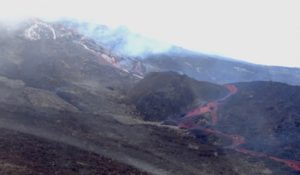
Fissure 8 continues to erupt lava into the channel leading northeastward from the vent.
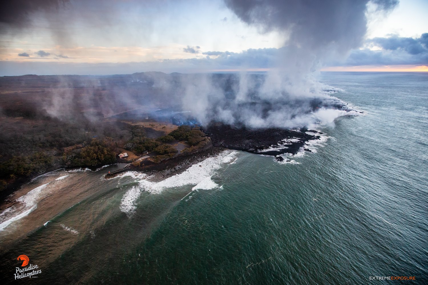
Lava advancing in the direction of Dead Trees, Isaac Hale Beach Park and the boat ramp at Pohoiki, appear to have not advanced significantly since yesterday, but spots of activity inland continue to creep along.
No new overflows were reported yesterday following the summit collapse event at 6:41 HST; no overflows were reported this morning. In the last day, the lava flow in the Ahalanui area has not extended significantly westward. The flow remains less than 0.1 miles from the Pohoiki boat ramp in Isaac Hale Park. The active ocean entry is still a few hundred yards to the east of this lava flow edge.
No other fissures are active this morning.
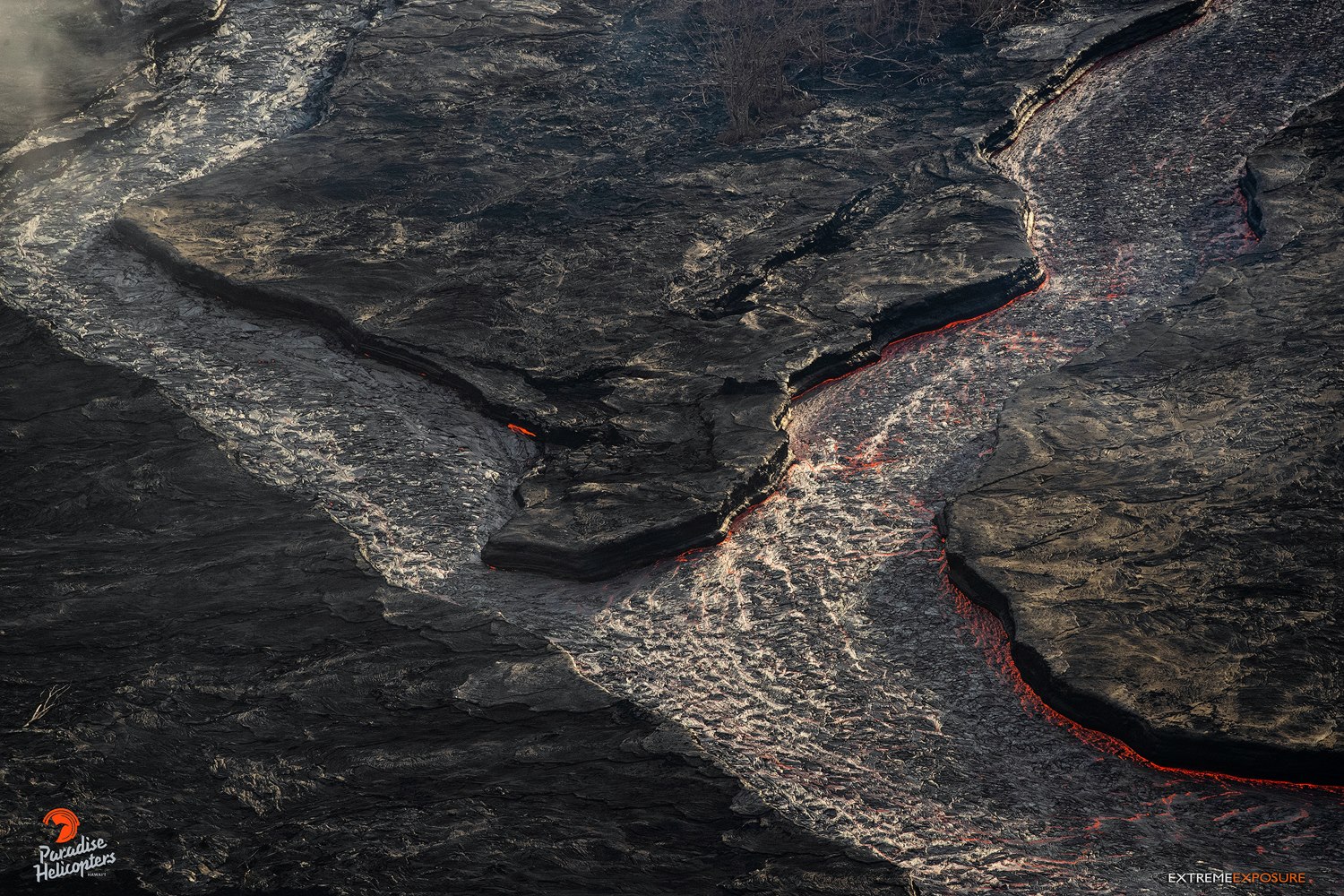
Kīlauea Volcano Summit
The most recent collapse event occurred at 6:41 AM HST yesterday, July 24, and was similar in character and magnitude to previous events. Seismicity has increased steadily since then; since yesterday afternoon the number of events per hour has fluctuated between about 20 and 40. The next collapse event is expected this afternoon or evening.
Source : HVO.
Photo : Bruce Omori
Philippines , Kanlaon :
KANLAON VOLCANO BULLETIN 26 July 2018 08:00 A.M
Kanlaon Volcano’s seismic monitoring network recorded five (5) volcanic earthquakes during the past 24 hours. Ground deformation data from continuous GPS measurements indicate a more pronounced inflation of the edifice since December 2017, signifying pressurization deep beneath the edifice. Sulfur dioxide (SO2) emission was measured at an average of 2,131 tonnes/day on 04 July 2018.

Alert Level 2 status prevails over Kanlaon Volcano, which means that the volcano is undergoing a moderate level of unrest due to probable intrusion of magma at depth that may or may not lead to a magmatic eruption. The local government units and the public are strictly reminded that entry into the 4-kilometer radius Permanent Danger Zone (PDZ) is strictly prohibited due to the further possibilities of sudden and hazardous steam-driven or phreatic eruptions. Civil aviation authorities must also advise pilots to avoid flying close to the volcano’s summit as ejecta from any sudden phreatic eruption can be hazardous to aircraft.
DOST-PHIVOLCS is closely monitoring Kanlaon Volcano’s activity and any new development will be relayed to all concerned.
Source : Phivolcs.
Colombia , Chiles / Cerro Negro :
Subject: Activity bulletin of Chiles and Cerro Negro volcanoes
The level of activity of volcanoes is maintained at the level:
YELLOW LEVEL ■ (III): CHANGES IN THE BEHAVIOR OF VOLCANIC ACTIVITY
Following the activity of VOLCANS CHILES and CERRO NEGRO, the COLOMBIAN GEOLOGICAL SERVICE (SGC) reports that:
For the period evaluated between July 17 and 23, 2018 seismicity in the region of Chiles volcanoes – Cerro Negro, showed a slight increase in both the number and in the released energy compared to the previous week by maintaining the predominance of the seismicity associated with the fracturing of rocks inside the volcanic building.
These earthquakes are preferably located southwest of the Chiles volcano, with distances between 0.2 and 1.7 km from the summit (4700 m). Other events were located scattered in the area of influence of the two volcanoes, with a depth of between 2.1 and 9.5 km and a maximum epicentral distance of 12 km. The local magnitude of this seismicity ranged from -0.5 to 1.9 on the Richter scale.
The Colombian Geological Service and the ECUADOR INSTITUTO GEOFÍSICO DE LA ESCUELA POLITECNICA NACIONAL closely follow the evolution of this seismic and volcanic activity and will report without delay on the changes detected.
Source : SGC.
Japan , Asamayama :
36.406°N, 138.523°E
Elevation 2568 m
JMA stated that during 16-23 July white plumes rose as high as 300 m above Asamayama’s summit crater. Weak crater incandescence was visible for the first time since 23 December 2017. The Alert Level remained at 2 (on a scale of 1-5).
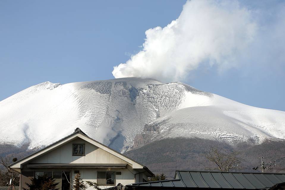
Asamayama, Honshu’s most active volcano, overlooks the resort town of Karuizawa, 140 km NW of Tokyo. The volcano is located at the junction of the Izu-Marianas and NE Japan volcanic arcs. The modern Maekake cone forms the summit and is situated east of the horseshoe-shaped remnant of an older andesitic volcano, Kurofuyama, which was destroyed by a late-Pleistocene landslide about 20,000 years before present (BP). Growth of a dacitic shield volcano was accompanied by pumiceous pyroclastic flows, the largest of which occurred about 14,000-11,000 BP, and by growth of the Ko-Asama-yama lava dome on the east flank. Maekake, capped by the Kamayama pyroclastic cone that forms the present summit, is probably only a few thousand years old and has an historical record dating back at least to the 11th century CE. Maekake has had several major plinian eruptions, the last two of which occurred in 1108 (Asamayama’s largest Holocene eruption) and 1783 CE.
Source: Agence météorologique japonaise (JMA) , GVP.