July 02 , 2018.
Kilauea , Hawai :
Sunday, July 1, 2018, 9:14 AM HST (Sunday, July 1, 2018, 19:14 UTC)
19°25’16 » N 155°17’13 » W,
Summit Elevation 4091 ft (1247 m)
Current Volcano Alert Level: WARNING
Current Aviation Color Code: ORANGE
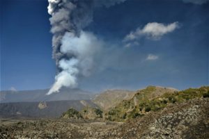
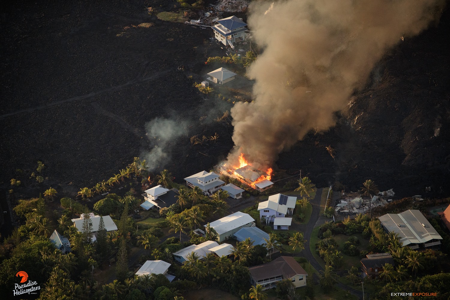
Kīlauea Volcano Lower East Rift Zone
The eruption in the lower East Rift Zone (LERZ) continues with no significant change during the past 24 hours.
July 1, 2018 Still More Homes Destroyed Local News from Mick Kalber on Vimeo.
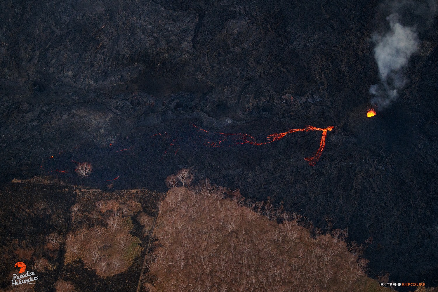
Fountains from Fissure 8 spatter cone continue to supply lava to the open channel with intermittent small, short-lived overflows. These overflows rarely extend beyond the existing flow field. No active overflows were observed during this morning’s helicopter overflight.The spatter cone is now about 55 m (180 ft) tall at its highest point, and fountains rarely rise above that point. At the coast, the northern margin of the flow field is still oozing pasty lava at several points in the area of Kapoho Beach Lots. Lava was entering the sea over a broad area this morning primarily on the northern side of the entry area. As shown by the June 29 thermal map of the flow field, the lava channel has crusted over about 0.8 km (0.5 mi) inland of the ocean entry; lava oozing from the flow’s molten interior into the ocean along most of its broad front.
Fissure 22 is spattering about 50-80 m above conical spatter cone and feeding a short lava flow that is moving slowly to the northeast along the edge of earlier flows.
Pele’s hair and other lightweight volcanic glass fragments from the lava fountain at Fissure 8 continue to fall downwind of the fissure, dusting the ground within a few hundred meters (yards) of the vent. High winds may waft lighter particles to greater distances. Residents are urged to minimize exposure to these volcanic particles, which can cause skin and eye irritation similar to volcanic ash.
HVO field crews are on site tracking the fountains, lava flows, and spattering from Fissure 8 as conditions allow and are reporting information to Hawaii County Civil Defense. Observations are also collected on a daily basis from cracks in the area of Highway 130; no changes in temperature, crack width, or gas emissions have been noted for several days.
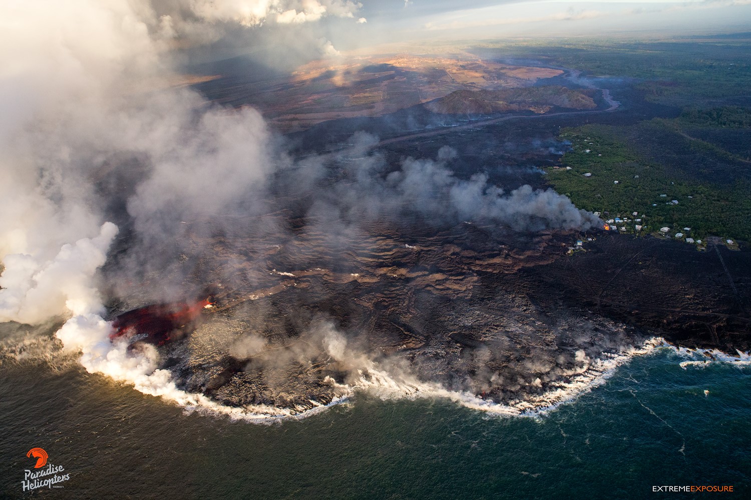
A view of the ocean entry, with a wide river of lava pouring into the sea on the left, and the remaining homes being threatened by the expanding flow field. Again, note the relief on the ‘a‘a flow field… those ripples are more than 50′ high, on top of the previous flow.
Volcanic gas emissions remain very high from Fissure 8 and 22 eruptions.
The ocean entry is a hazardous area. Venturing too close to an ocean entry on land or the ocean exposes you to flying debris from sudden explosive interaction between lava and water. Also, the lava delta is unstable because it is built on unconsolidated lava fragments and sand. This loose material can easily be eroded away by surf, causing the new land to become unsupported and slide into the sea. Additionally, the interaction of lava with the ocean creates « laze », a corrosive seawater plume laden with hydrochloric acid and fine volcanic particles that can irritate the skin, eyes, and lungs.
Magma continues to be supplied to the Lower East Rift Zone. Seismicity remains relatively low in the area with numerous small magnitude earthquakes and low amplitude background tremor. Low amplitude tremor increased slightly on June 29 associated with renewed activity at Fissure 22. Higher amplitude tremor is occasionally being recorded on seismic stations close to the ocean entry.
Kīlauea Volcano Summit
After the collapse/explosive event at 02:51 PM HST yesterday, seismicity dropped abruptly from a high of 25-30 earthquakes per hour (many in the magnitude 2-3 range) prior to the collapse explosion down to 5 or fewer earthquakes per hour afterwards. This morning, the summit seismicity is at 25-35 earthquakes per hour as we await the next collapse/explosive event. Inward slumping of the rim and walls of Halemaʻumaʻu continues in response to ongoing subsidence at the summit.
Sulfur dioxide emissions from the volcano’s summit have dropped to levels that are about half those measured prior to the onset of the current episode of eruptive activity. This gas and minor amounts of ash are being transported downwind, with small bursts of ash and gas accompanying intermittent explosive activity.
Source : HVO.
Photos : Bruce Omori
Vidéo : Mick Kalber
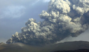
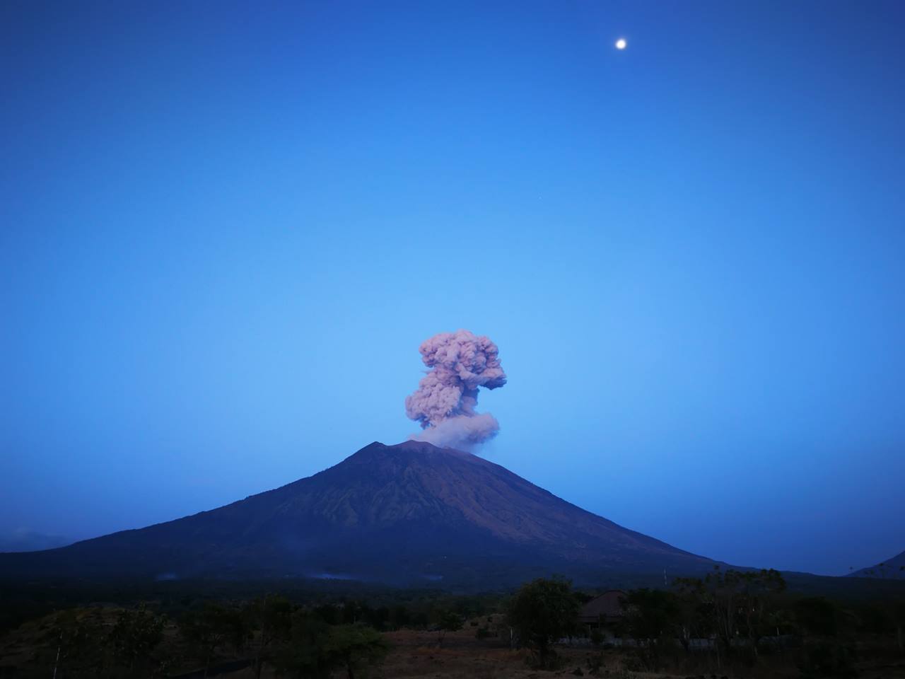
Agung , Indonésie :
VOLCANO OBSERVATORY NOTICE FOR AVIATION – VONA.
Issued: July 02 , 2018 .
Volcano: Agung (264020)
Current Aviation Colour Code: ORANGE
Previous Aviation Colour Code: orange
Source: Agung Volcano Observatory
Notice Number: 2018AGU37
Volcano Location: S 08 deg 20 min 31 sec E 115 deg 30 min 29 sec
Area: Bali, Indonesia
Summit Elevation: 10054 FT (3142 M)
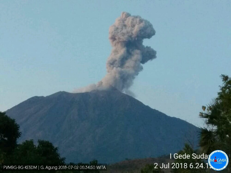
Volcanic Activity Summary:
Eruption with volcanic ash cloud at 05h43 UTC (13h43 local). Eruption and ash emission is not continuing.
Volcanic Cloud Height:
Best estimate of ash-cloud top is around 12294 FT (3842 M) above sea level, may be higher than what can be observed clearly. Source of height data: ground observer.
Other Volcanic Cloud Information:
Ash-cloud is moving west-southwest.
Remarks:
Seismic activity is characterized by low frequency earthquakes.
Data monitoring
Visually, eruption incidents are always observed. From 27 June to 2 July 2018 at 09:00 WITA, the height of the eruption column (gas and ash) tended to decrease but not significantly, from 2500 m above the peak to 200-2000 m above of the peak. At night and early in the morning, the glow above the crater is still observed. This indicates the presence of fresh lava with high temperatures in the crater and always the movement of magma on the surface.
The seismic activity of Gunung Agung is still dominated by low frequency earthquakes (bursts and eruptions). The number of events from June 28 to July 2, 2018 increased from 69 events per day to 14 events per day. Despite the decline, the amount of issue is still high. The last earthquakes were recorded on July 2, 2018 at 06:19 WITA, 06:41 WITA and 06:55 WITA. The continuous tremor has not been recorded since June 29th at 05:00 WITA. High frequency earthquakes (volcanic earthquakes and local tectonics) recorded about two events per day.
The seismic amplitude on Mount Agung strongly increased on June 28, 2018 from about 9:00 am, the seismic magnitude strongly decreased on June 29, 2018 at 05:00 WITA. After that, the seismic amplitudes tend to fluctuate and have not shown a clear improvement trend.
Prior to the June 28-29, 2018 eruption, deformation modeling indicated rapid body swelling of Mount Agung with a 1 cm uplift. Post eruption of June 29 – July 1, 2018, the body of the mountain has experienced a slight deflation, but the volcanic system has not fully experienced relaxation. The measurement of the deformation always indicates the development of the magmatic pressure at depth.
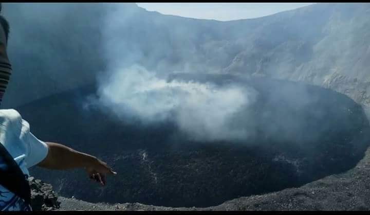
The satellite images show an effusive eruption of lava flows in the crater that continues to this day. In the period from June 28 to July 1, 2018, a new lava flows from the center of the crater and extends radially (circularly) with a volume of about 4-5 million cubic meters. Since the eruption of November 21, 2017 and until July 1, 2018, the total volume of the lava dome has reached approximately 27-28 million cubic meters or nearly 50% of the Mount Agung crater which has an empty volume of about 60 million cubic meters. The difference in height between the lowest crater lips (on the southwest side) and the highest lava dome surface (in the center of the crater) is about 85 to 90 meters.
The satellite images still record the existence of hotspots in the Mount Agung crater related to the lava effusion activity. During the period from June 28 to July 2, 2018, thermal energy tended to decrease from a high of 819 megawatts to 58 megawatts. Despite the decrease, the thermal energy is still high.
Analysis
Gunung Agung is still in a state of eruption. Currently, the eruption is generally effusive in the form of lava flows that fill the crater and in the explosive form of incandescent lava around the crater with ash eruption.
The possibility of filling the crater with lava material in a short time is still low because the lava effusion rate is still slow.
The activities of Gunung Agung are still in a developing and unstable state and the possibility of eruption (effusive and explosive) is still high.
Source : Magma Indonésie , PVMBG.
Photos : PVMBG , Puncak Gunung Agung Bali / Vincent Gougeau Pap S
Great Sitkin , Alaska :
AVO/USGS Volcanic Activity Notice
Current Volcano Alert Level: ADVISORY
Previous Volcano Alert Level: NORMAL
Current Aviation Color Code: YELLOW
Previous Aviation Color Code: GREEN
Issued: Sunday, July 1, 2018, 10:37 AM AKDT
Source: Alaska Volcano Observatory
Notice Number:
Location: N 52 deg 4 min W 176 deg 6 min
Elevation: 5709 ft (1740 m)
Area: Aleutians
Volcanic Activity Summary:
Earthquake activity at Great Sitkin Volcano has increased above background levels over the past day. Numerous small, shallow earthquakes are occurring beneath the summit at rates as high as 10-20 per hour. It is uncertain if this unrest will lead to any eruptive activity but this remains a possibility given the general degree of unrest at Great Sitkin over the past several months. Thus AVO is raising the Aviation Color Code and Alert Level to YELLOW /ADVISORY.
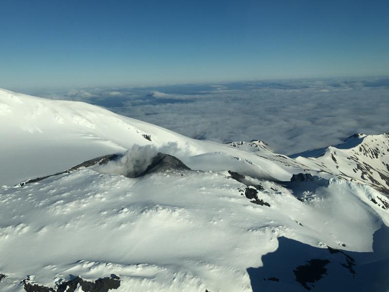
Minor steaming at the summit of Great Sitkin, June 17, 2018. Photo courtesy of Alaska Airlines Captain Dave Clum. A small ash deposit extends away from the vent, likely deposited during the June 10, 2018 explosion event.
AVO detected a brief steam and ash explosion at Great Sitkin on June 10, and earthquake activity then declined to background levels over a period of about 2 weeks. Over the past several days, nothing significant has been observed in satellite data and no other signs of unrest have been detected or reported to AVO.
Great Sitkin Volcano is monitored by a five-station seismic network on Great Sitkin Island and with additional seismic stations on the nearby islands of Igitkin, Adak, Kagalaska, and Kanaga. A six-element infrasound array to detect explosions (atmospheric pressure waves) was installed on Adak Island in June, 2017, although it is currently (June 2018) only partly operational. AVO also uses satellite imagery to monitor Great Sitkin Volcano.
Recent Observations:
[Volcanic cloud height] not applicable
[Other volcanic cloud information] Unknown
Remarks:
Great Sitkin Volcano is a basaltic andesite volcano that occupies most of the northern half of Great Sitkin Island, a member of the Andreanof Islands group in the central Aleutian Islands. It is located 43 km (26 miles) east of the community of Adak. Great Sitkin erupted at least three times in the 20th century, most recently in 1974. That eruption produced at least one ash cloud that likely exceeded an altitude of 25,000 ft above sea level. A poorly documented eruption occurred in 1945, also producing a lava dome that was partially destroyed in the 1974 eruption. A seismic swarm occurred from July 2016 through the end of 2017.
Source : AVO
Photo : Clum, Dave , 17 Juin 2018
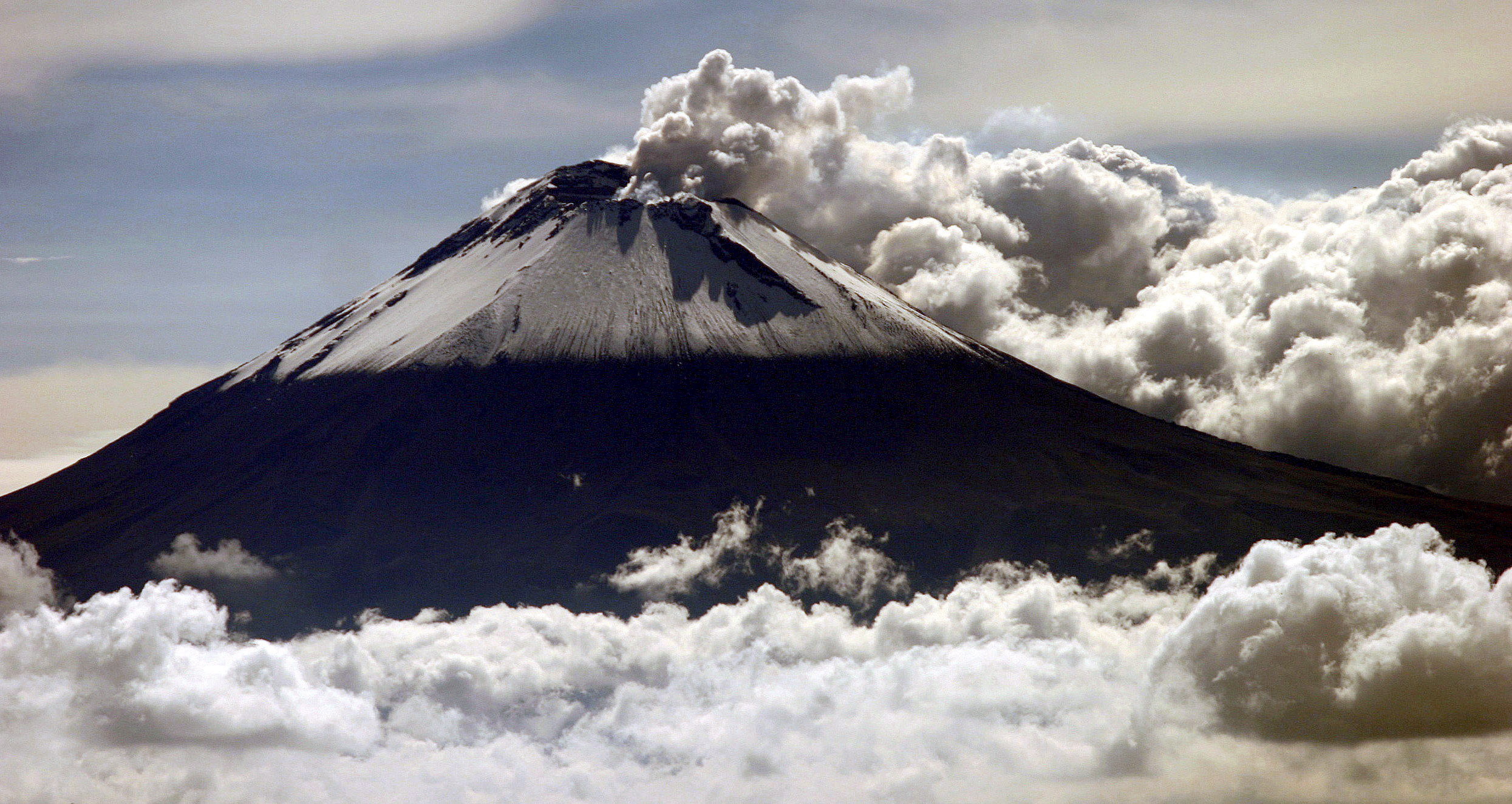
Popocatepetl , Mexico :
July 1, 11:00 am (June 30, 16:00 GMT)
During the last 24 hours, thanks to the surveillance systems of the Popocatepetl volcano, twelve low-intensity exhalations accompanied by steam and gas have been identified, as well as an explosion today at 05:01 h. In addition, two volcano-tectonic-type earthquakes yesterday at 17:44 h and today at 08:00 h, with a magnitude of M1.6 and M1.3, respectively, and 635 minutes of harmonic tremors were recorded.
During the night, a slight incandescence was observed on the crater.
At the time of this report, there is visibility on the volcano, the winds have a direction towards the West.
CENAPRED asked not to approach the volcano and in particular the crater, because of the risk of falling of projectiles, and in case of heavy rain, to remain far from the bottom of the ravines because of the danger of landslides and flows mud.
The volcanic warning light of the Popocatepetl volcano is located at Amarillo Phase 2.
Source : Cenapred.