November 12 2023.
Iceland , Reykjanes Peninsula :
The rate of ground deformation is much higher than previously measured on the Reykjanes Peninsula.
Around 800 earthquakes have been detected since midnight. The Department of Civil Protection and Emergency Management will hold a press conference at 12:00 p.m. to inform the public of the ongoing unrest and possible scenarios. Information updated regularly here and on X (formerly Twitter).
Updated November 11 at 12:00 p.m.
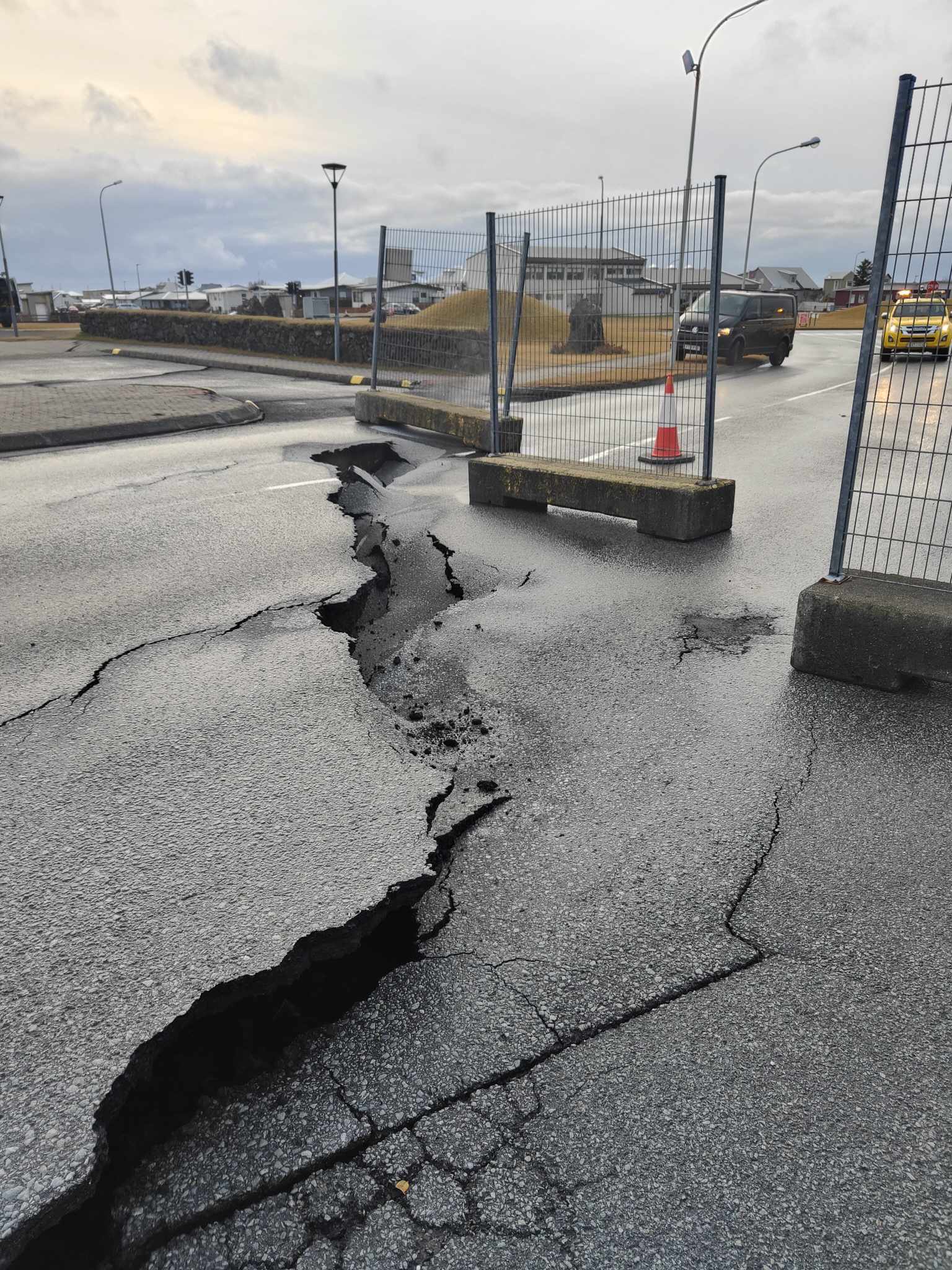
Since midnight, around 800 earthquakes have been measured in the region where the magma intrusion is occurring. The earthquake activity has diminished slightly in the past hours, but it remains high. Most of the recent earthquakes have occurred close to Grindavík, where the southwest end of the magmatic dyke is estimated to be located.
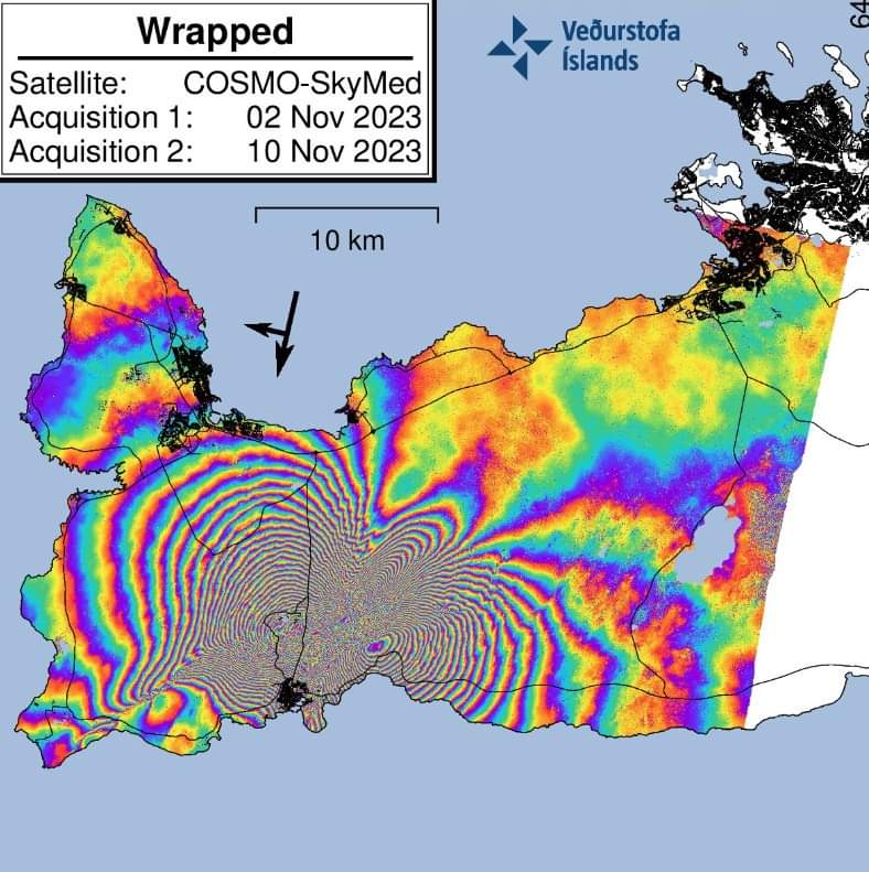
The numerous and tight fringes (each color cycle represents 1.5 cm of deformation) and the data from GNSS stations on the ground indicate a maximum deformation of approximately 130 cm which occurred in a few hours on the afternoon of November 10, in the Grindavik region.
Analysis of the earthquakes from today and yesterday is ongoing. The goal of this work is to better understand the evolution of the magma intrusion. Presently, the data indicates that the magma intrusion extends from Stóra-Skógsfell in the north to Grindavík in the south, where it extends beneath the sea. In accordance with the latest preliminary models, using the most recent satellite data acquired last night, the shallowest depth of the top of the magma intrusion north of Grindavík is 1.5 km. Joint interpretation of the ground and satellite measurements indicate that the size of the magma intrusion and the rate at which it is moving are several times larger than have been measured previously on the Reykjanes Peninsula. Our assessment is that an eruption, if it were to occur, will originate from the northern side of the magma intrusion. This means that there is a greater likelihood of an eruption beginning close to Sundhnjúkagígur.
Scientists are meeting regularly to interpret the data and update the latest models and hazard assessments. A meeting for journalists will be held at 12:00 at the Department of Civil Protection and Emergency Management. The current conditions and future scenarios will be discussed.
The likelihood of a volcanic eruption occurring in the near future is deemed considerable.
Significant likelihood of a volcanic eruption in the coming days
Models show a 15-km long magma intrusion, located just northwest of Grindavík. Updated 11. November at 6:30
At 18:00 today, 11 November, a status meeting concluded between scientists at the Icelandic Meteorological Office, the University of Iceland, and the Department of Civil Protection and Emergency Management. The purpose of the meeting was to discuss the latest measurements of seismicity and ground deformation in the region of Grindavík, in addition to reviewing the latest geophysical models and hazard assessments. From combined assessments of satellite radar imagery, ground-based GPS measurements, and seismicity, it was concluded that the ongoing dike intrusion represents a serious volcanic hazard.
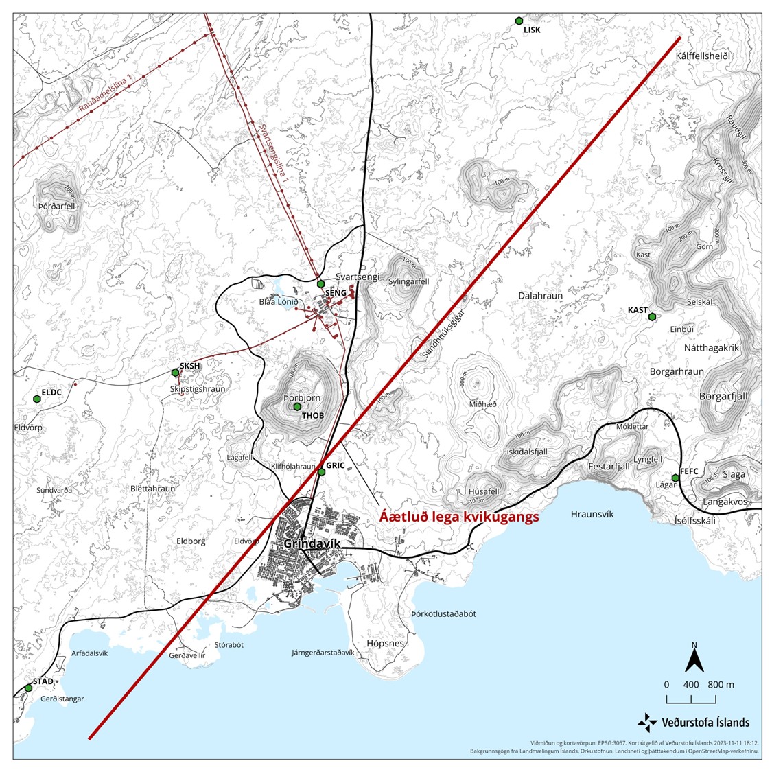
From geophysical models of the dike intrusion, it is estimated that the intrusion is propagating upwards slowly, with magma thought to be 800 m beneath the surface. The exact location of a possible eruption site is unknown, but the 15-km length and orientation of the dike gives a good indication of possible sources. The overall assessment from the status meeting was that the likelihood of a volcanic eruption is high, and that an eruption could be possible on a timescale of just days. Based on the extent of the dike, magma could emerge from its southern, just outside of Grindavik. Therefore, the likelihood of a submarine eruption has also increased, so preparations must be made for the possibility of explosive activity. A hazard area has been defined based on the location of the dike, as shown in the map.
Source : IMO.
Photos : IMO /INGV , IMO .
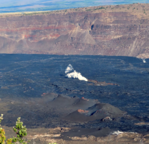
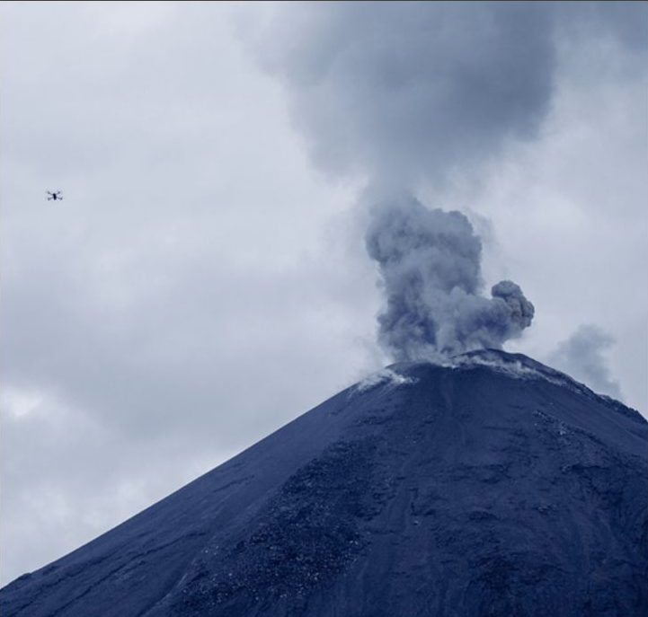
Alaska , Katmai :
Saturday, November 11, 2023, 1:59 PM AKST (Saturday, November 11, 2023, 22:59 UTC)
58°16’44 » N 154°57’12 » W,
Summit Elevation 6716 ft (2047 m)
Current Volcano Alert Level: NORMAL
Current Aviation Color Code: GREEN
Strong northwesterly winds in the vicinity of Katmai and the Valley of Ten Thousand Smokes have picked up loose volcanic ash erupted during the 1912 Novarupta-Katmai eruption and are carrying it to the southeast this morning. The National Weather Service has issued a SIGMET for this low-level event and suggests that the maximum cloud height is 5,000 ft (1.5 km) above sea level.
This phenomenon is not the result of recent volcanic activity and occurs during times of high winds and dry snow-free conditions in the Katmai area and other young volcanic areas of Alaska. No eruption is in progress. Trident Volcano remains at color code YELLOW due to elevated earthquake activity, while other volcanoes of the Katmai area (Snowy, Griggs, Katmai, Novarupta, Mageik, Martin) remain at color code GREEN. Resuspended volcanic ash should be considered hazardous and could be damaging to aircraft and health.
Source : AVO
Photo : AVO ( Archive Katmai / Novarupta)
Chile , Hudson :
Seismology
The seismological activity of the period was characterized by the recording of:
821 seismic events of type VT, associated with the fracturing of rocks (Volcano-Tectonics). The most energetic earthquake had a Local Magnitude (ML) value equal to 2.8, located 6.6 km to the South-South-East and with a depth of 5.0 km from the center of the caldera.
186 LP type seismic events, associated with fluid dynamics inside the volcanic system (Long Period). The size of the largest earthquake evaluated from the Reduced Displacement (RD) parameter was equal to 13 cm2.
48 HB seismic events, associated with both rock fracturing and fluid dynamics within the volcanic system (Hybrid). The most energetic earthquake had a reduced displacement (DR) value of 62 cm2 and a local magnitude (ML) value equal to 1.7, located 6.7 km to the South-South-West and with a depth of 4 .4 km from the center of the caldera.
Fluid geochemistry
No anomalies have been reported in emissions of sulfur dioxide (SO2) into the atmosphere in the area near the volcano, according to data published by the Tropospheric Monitoring Instrument.
Thermal anomalies by satellites
During the period, no thermal alerts were recorded in the area associated with the volcanic system, according to data processed by the Mid-Infrared Observation of Volcanic Activity (MIROVA). In addition, no radiance anomalies were reported thanks to the analytical processing of Sentinel 2-L2A satellite images, in combination of false color bands.
Geodesy
From the data provided by 2 continuous GNSS stations, which allow the monitoring of the deformation of the volcanic edifice, we observe that the trend of movement towards the South-East is maintained in the station closest to the caldera, at a rate of 0.4 cm/month. Likewise, the vertical component has a low displacement rate of 0.2 cm/month.
Surveillance cameras
The images provided by the fixed camera, installed near the volcanic system, did not record degassing columns or variations linked to surface activity.
Activity remained at levels considered usual, suggesting stability of the volcanic system. The technical volcanic alert is maintained in:
GREEN TECHNICAL ALERT: Active volcano with stable behavior – There is no immediate risk
Source : Sernageomin
Photo : meganoticias
Ecuador , Reventador :
DAILY REPORT ON THE STATE OF REVENTADOR VOLCANO, Saturday November 11, 2023.
Information Geophysical Institute – EPN.
Surface activity level: Moderate, Surface trend: No changes
Internal activity level: Moderate, Internal trend: No changes
Seismicity: From November 10, 2023, 11:00 a.m. to November 11, 2023, 11:00 a.m.:
The following table shows the number of seismic events from the reference station in the last 24 hours.
Explosion (EXP) 52
Long Period (LP) 20
Transmitting Tremor (TREMI) 8
Volcano-tectonic (VT) 1
Precipitation/Lahars:
Rainfall is not recorded. **In the event of heavy rains, these could remobilize the accumulated materials, generating mud and debris flows which would descend the sides of the volcano and flow into adjacent rivers.
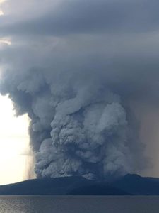
Emissions/ash column:
Yesterday afternoon, according to the surveillance camera system, an emission of gas and ash was recorded, the column of which did not exceed 500 meters above the level of the crater, in a West-North-West direction. Since this morning, thanks to the camera system, several emissions have been observed whose height of the columns exceeded 600 meters above the level of the crater and were directed towards the West and the North-West. In addition to this, the VAAC in Washington published a report reporting an emission of gas and ash whose column reached 1010 meters above the level of the crater and headed towards the West-Northwest .
Other monitoring parameters:
The FIRMS satellite system recorded 3 thermal anomalies, while the MIROVA-VIIRS recorded 1 weak thermal anomaly in the last 24 hours.
Observation:
Yesterday afternoon, the volcano remained cloudy. Yesterday evening and at the start of the day, thanks to the surveillance camera system, several episodes of incandescence were observed at the level of the crater, accompanied by descents of material along the flanks, reaching 600 meters below the level of the crater. Since this morning, the volcano has been rather cloudy.
Niveau d’alerte: Orange.
Source et photo : IGEPN.
Costa Rica , Poas / Rincon de la Vieja :
Poás Volcano
Latitude: 10.20°N;
Longitude: 84.23°W;
Altitude: 2687 m
Current activity level: Warning
Possible manifestations: Small eruptions, bubble or geyser, significant gas emission, increase in temperature (incandescence), seismic swarms or volcanic tremor, slight inflation-extension of the volcanic edifice.
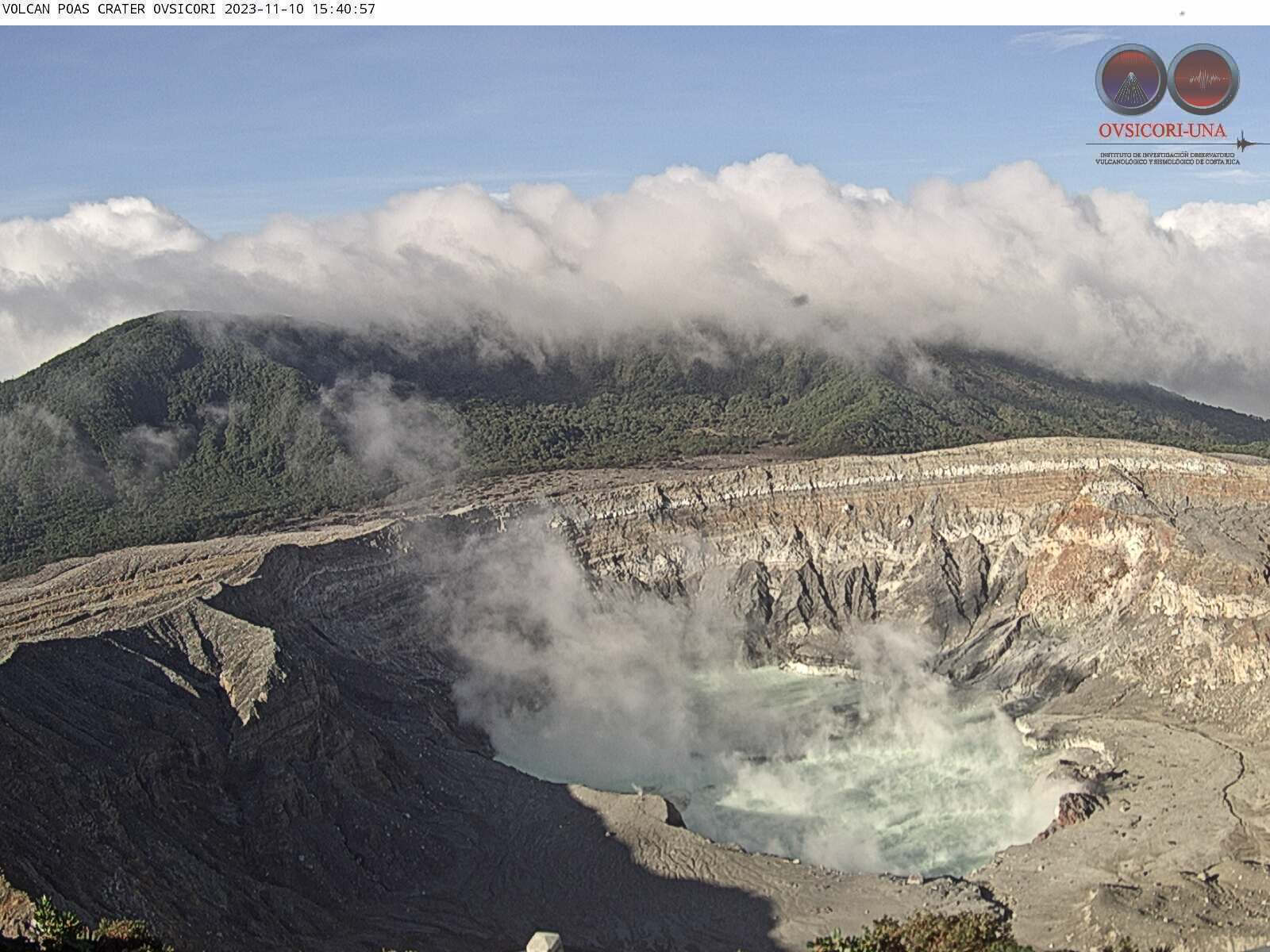
The Poás volcano maintains a tremor variable in amplitude and frequency, dominating the frequency band between 2 and 6 Hz. Sometimes broad-spectrum, high-amplitude tremors are recorded for periods less than 1 hour. Geodetic observations show no variation or deformation of the volcanic massif, both horizontally and vertically. The previous week, the SO2 flow showed a value of 226 ± 25 t/d. The SO2/CO2 ratio measured in the plume has risen to values of 1.7 while the H2S/SO2 ratio remains very low (<0.01). The concentration of SO2 in the ambient air around the Visitor Viewpoint reached a weekly maximum of 3.7 ppm. The lake level fell by approximately 40 cm during the week.
Rincon de la Vieja Volcano:
Latitude: 10.83°N;
Longitude: 85.34°W;
Altitude: 1916 m
Current activity level: Caution
Possible manifestations: Small eruptions, bubble or geyser, significant gas emission, increase in temperature (incandescence), seismic swarms or volcanic tremor, slight inflation-extension of the volcanic edifice, hot springs.
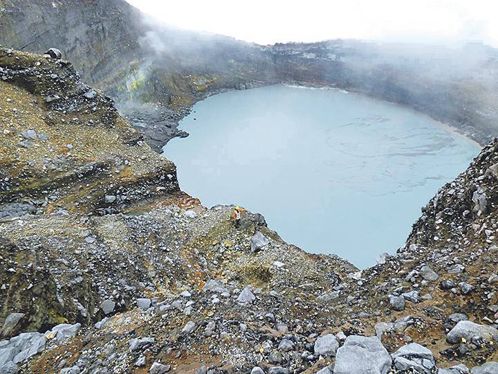
No eruptions were recorded this week, but there were 10 exhalations rich in water vapor and gas of magmatic origin. The background tremor remains segmented and of low amplitude. In recent days, tremors predominate in two independent frequency bands; one between 3 and 4 Hz and the second between 0.7 and 1 Hz. Short tremors are also recorded, associated with small exhalations or bubbles in the hyperacid lake. This week, the number of occurrences of volcano-tectonic signals at the top of the volcano has increased. According to geodetic measurements, we observe that the inflation of the volcanic massif has decreased in speed over the last week. The CO2/SO2 ratio measured in the plume has decreased compared to the previous week with a weekly average of 1.7 ± 0.7 and the H2S/SO2 ratio is 0.2 ± 0.1. During the previous week, 334 ± 105 t/d was recorded as the average SO2 flow. These averages are among the highest recorded in recent years. The TROPOMI sensor on the Sentinel-5P satellite continues to frequently detect the SO2 plume from the volcano, but a downward trend in its value since mid-October is confirmed.
Source : Ovsicori
Photos : Ovsicori , Auteur inconnu.