June 07 , 2018.
Pu’u ‘Ō’ō / Kilauea , Hawai :
Tuesday, June 5, 2018, 10:28 PM HST (Wednesday, June 6, 2018, 08:28 UTC)
19°25’16 » N 155°17’13 » W,
Summit Elevation 4091 ft (1247 m)
Current Volcano Alert Level: WARNING
Current Aviation Color Code: RED
Kīlauea Volcano , Lower East Rift Zone:
Vigorous eruption of lava continues from the lower East Rift Zone (LERZ) fissure system in the area of Leilani Estates and Lanipuna Gardens.
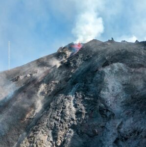
Persistent lava fountaining at Fissure 8 is reaching heights of 150-180 feet. This eruptive activity continues to feed a channel transporting lava to the east to the ocean entry in the Kapoho Bay area. Minor breakouts along the channelized flow have been very small and stagnated before travelling any significant distance. HVO’s late afternoon overflight showed that the Fissure 8 flow is continuing to form a lava delta with limited continuing advances into the surviving parts of the Kaphoho Beach Lots and Vacationlands neighborhoods. The northernmost lobe of the Fissure 8 flow is advancing very slowly to the northeast. No other fissure vents are active.
The vigorous lava fountain at Fissure 8 reached heights of 45 m (150 ft) as shown in this image taken around 9:30 AM.
Pele’s hair and other lightweight volcanic glass from high fountaining of Fissure 8 are falling downwind of the fissure and accumulating on the ground within Leilani Estates. Winds may waft lighter particles to greater distances. Residents are urged to minimize exposure to these volcanic particles, which can cause skin and eye irritation similar to volcanic ash.
HVO field crews are on site tracking the fountains, lava flows, and spattering from multiple fissures as conditions allow and are reporting information to Hawaii County Civil Defense.
Volcanic gas emissions remain very high from the fissure eruptions. Trade wind conditions are bringing vog to the south and west sides of the Island of Hawaii. Afternoon easterly winds may bring vog to communities in the Volcano area.
Kīlauea Volcano Summit:
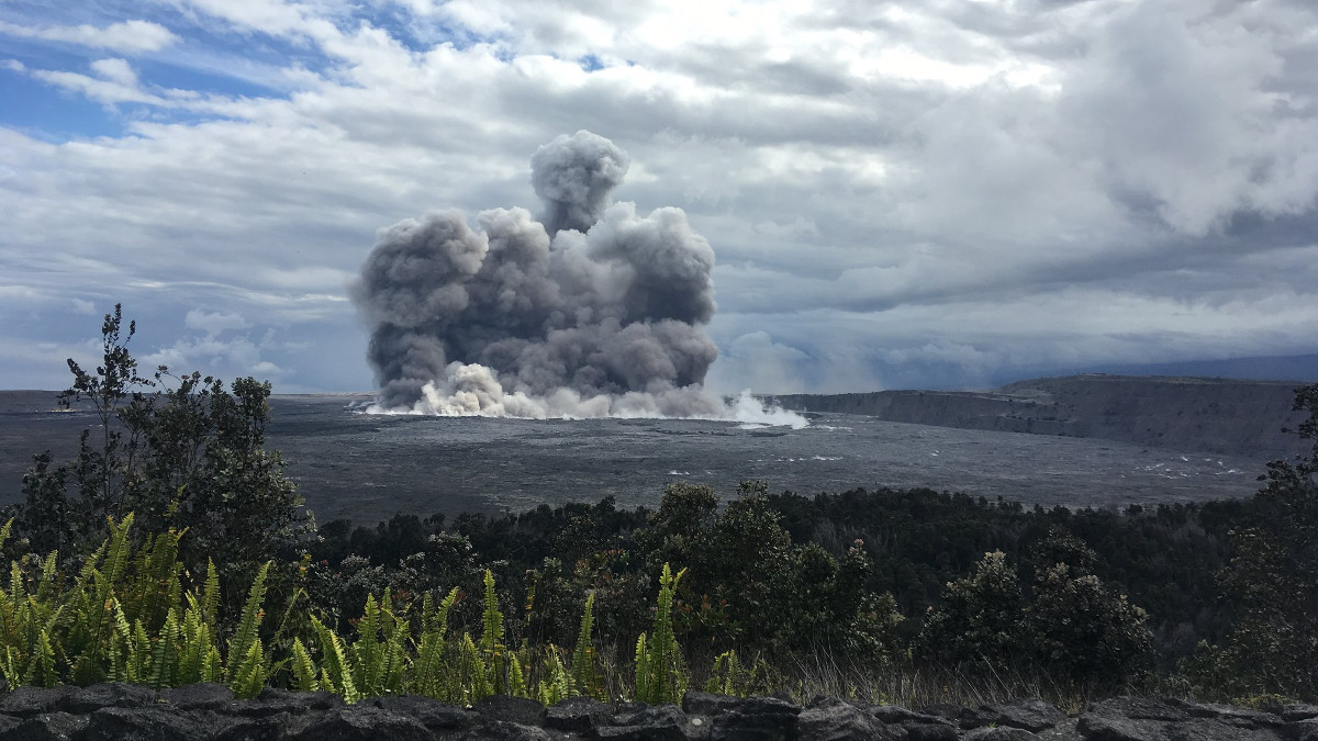
Earthquake activity dropped after Tuesday morning’s small explosion but is slowly rising now, following the pattern of previous events of this type. Monitoring data indicate that subsidence at the summit continues. The mid-day observation flight showed additional Inward slumping of the rim and walls of Halema`uma`u.
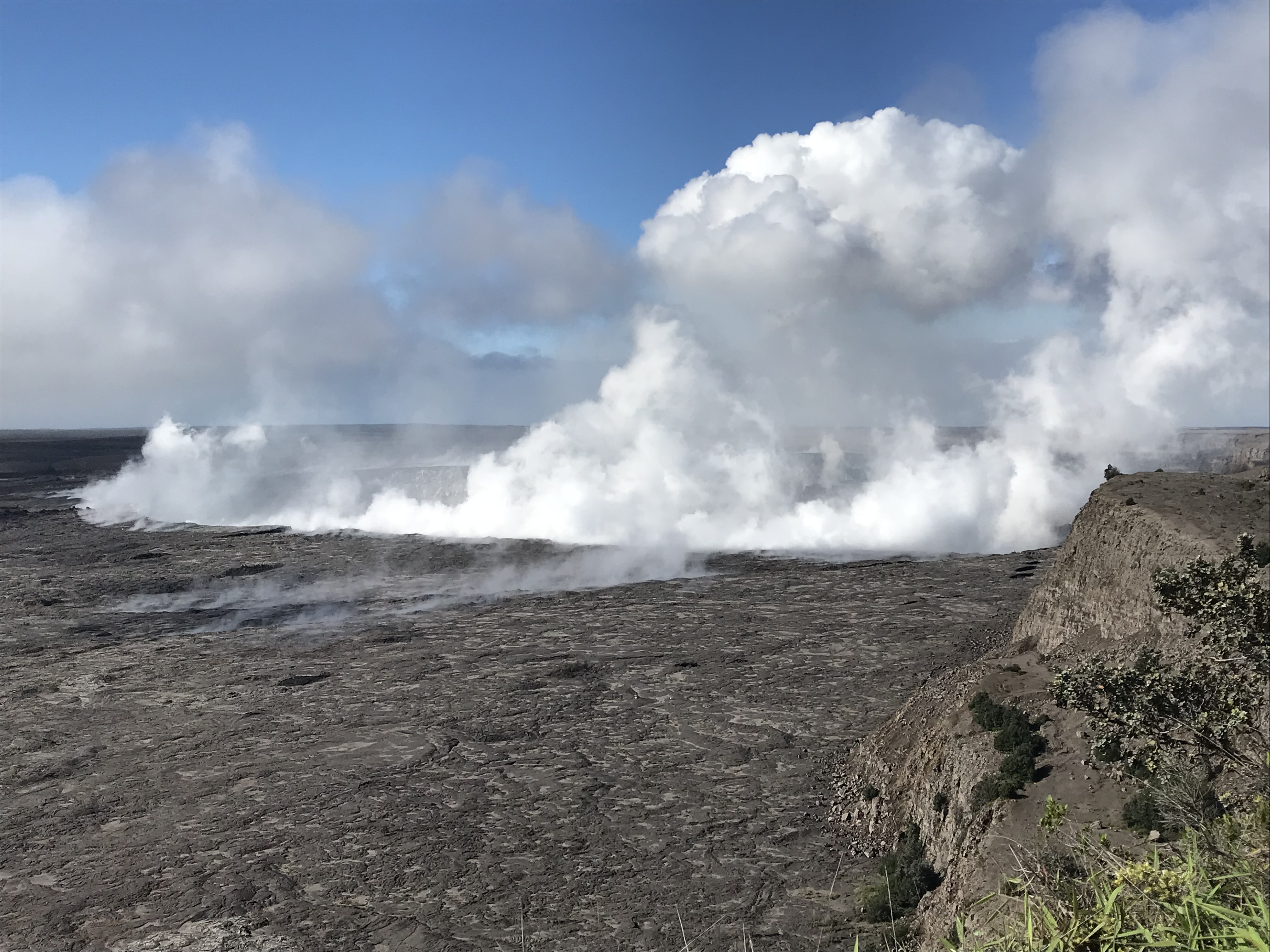
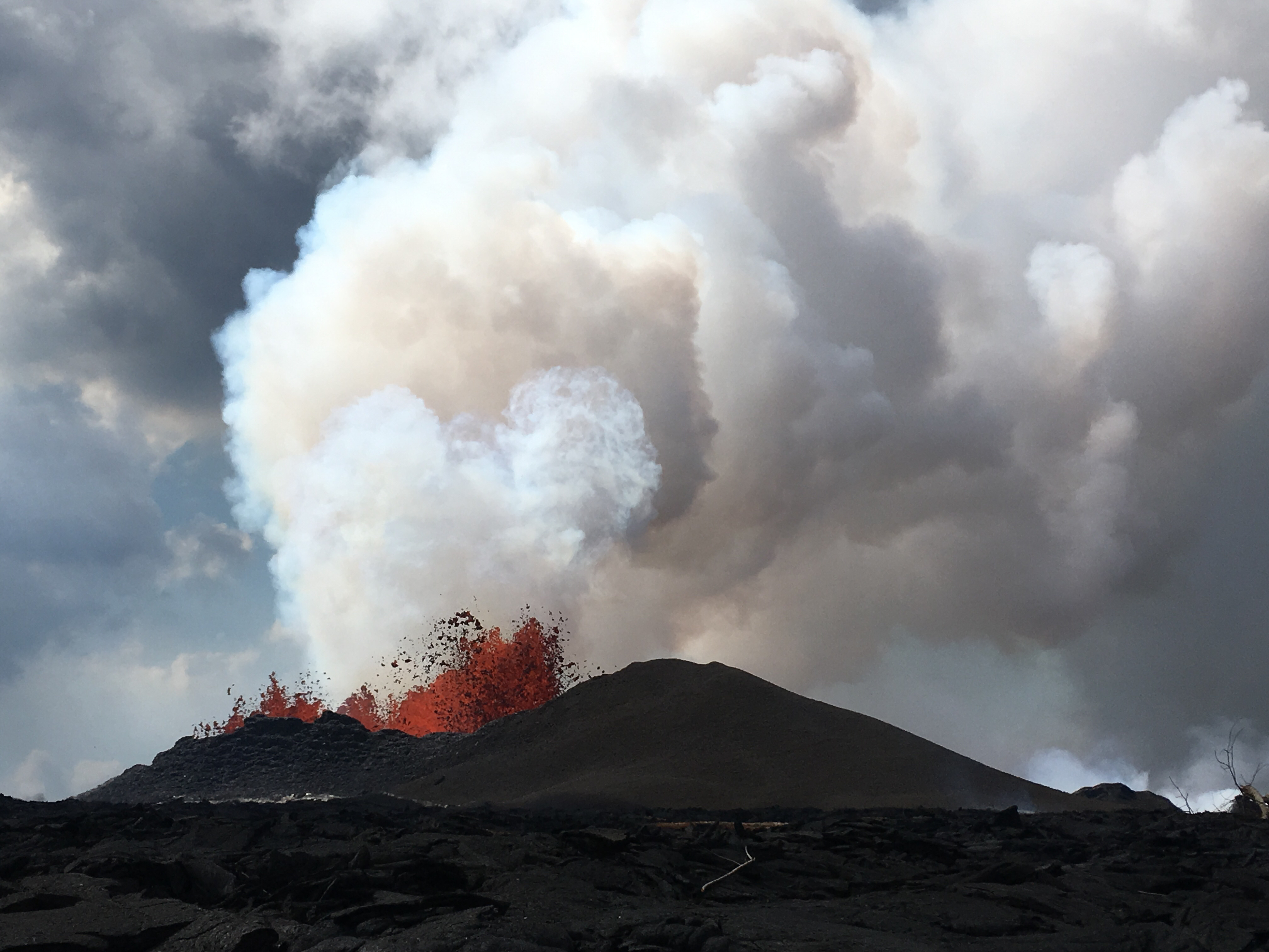
Morning view of Halema‘uma‘u and the adjacent caldera floor from the Kīlauea overlook. Heavy steam dominates the view, and strong winds are blowing the plume to the Southwest.
Locally felt earthquakes are expected to continue, and further ash explosions are likely.
Over the last week, sulfur dioxide emissions from the volcano’s summit have decreased, but emission rates remain high enough to impact air quality in downwind regions. Additional bursts of gas released with intermittent explosive activity are also transported downwind and may temporarily affect air quality as well.
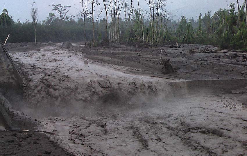
The reality of what took place Kapoho is devastating. Of the 348 homes we count in Kapoho and Vacationland only 101 homes remain at this time. 247 have been destroyed as lava took both complexes. Aerial images show a pocket of homes north of Kapoho earlier today and a stalled flow front. The Kapoho kipuka of homes shows much similar damage to images seen yesterday. Suggesting as well that advancement has stalled.
Vacationland lost more homes this afternoon, very few homes remain. The flow that had traveled down Hwy 132 to 4-corners wrapped around Green Mountain and fell into Vacationland last night. Up to this point a total of 468 homes have been lost since May 3rd.
The lava flow near Papaya Farms Road and Holo Lio Road continues to produce a very slow moving A’a flow. Progression is slow but activity continues.
Wednesday, June 6, 2018, 2:34 PM HST (Thursday, June 7, 2018, 00:34 UTC)
Kīlauea Volcano Lower East Rift Zone
Vigorous eruption of lava continues from the lower East Rift Zone (LERZ) fissure system in the area of Leilani Estates.
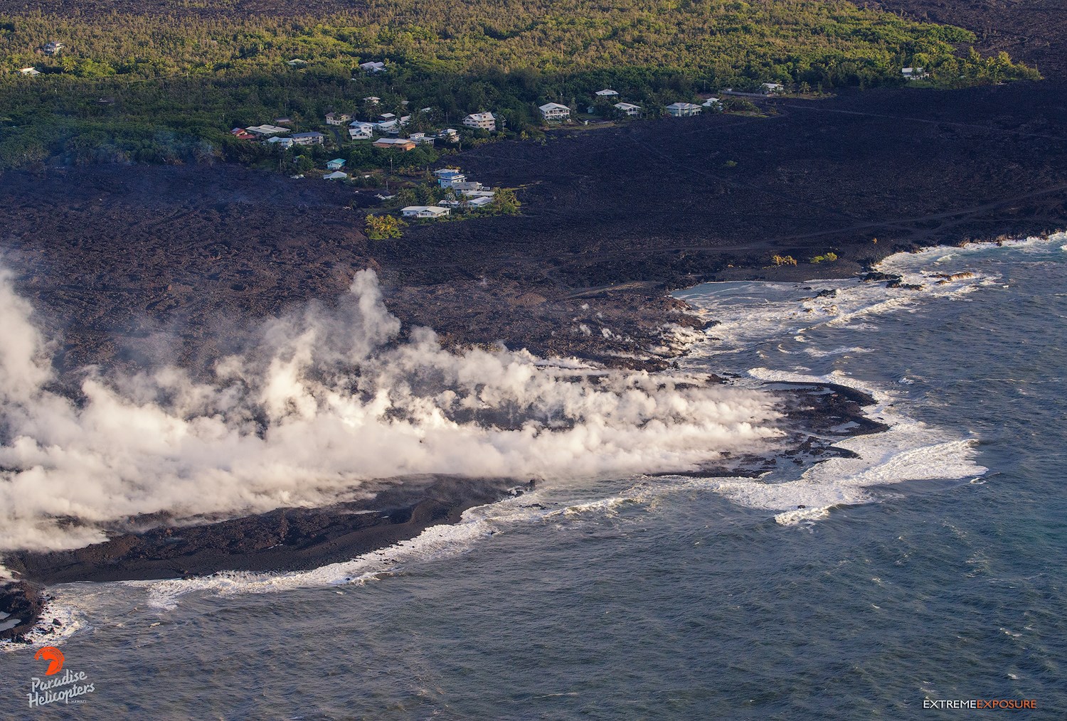
This morning, lava fountaining at Fissure 8 continued to reach heights of 150-180 feet, feeding a stable channel to the east to the ocean entry in the Kapoho Bay area. Lava is entering the ocean in the Vacationland subdivision. Vacationland has been completely covered by lava, and overnight the flow expanded north by 100 m within Kapoho Beach Lots. The lava delta that formed at Kapoho Bay extended slightly overnight.
The northern lobe of the Fissure 8 flow shows no signs of activity this morning, and there is only wispy smoke at the flow front. No other fissures are active.
HVO field crews are on site tracking the fountains, lava flows, and spattering from multiple fissures as conditions allow and are reporting information to Hawaii County Civil Defense.
Volcanic gas emissions remain very high from the fissure eruptions. For the next few days wind conditions may bring vog not only to the south and west sides of the Island of Hawaii, but also the island’s interior.
Magma continues to be supplied to the lower East Rift Zone. Earthquake locations have not moved farther downrift in the past few days and the number of located earthquakes remains low. Seismicity remains relatively low with numerous small magnitude earthquakes and low amplitude background tremor.
Kīlauea Volcano Summit
Earthquake activity is increasing after Tuesday morning’s small explosion, with ten M3+ earthquakes since 5 am in the Kīlauea summit area. This pattern suggests that more felt earthquakes and a small explosion are likely within the next few hours. Monitoring data indicate that subsidence at the summit and inward slumping of the rim and walls of Halema`uma`u continues.
Over the last week, sulfur dioxide emissions from the volcano’s summit have decreased, but emission rates remain high enough to impact air quality in downwind regions. Additional bursts of gas released with intermittent explosive activity are also transported downwind and may temporarily affect air quality as well.
Source : HVO, Dane DuPont.
Photos : USGS , Bruce Omori
Video : USGS
Fuego , Guatemala :
The National Institute of Seismology, Volcanology, Meteorology and Hydrology (INSIVUMEH) issued a bulletin on Wednesday to warn that « it is possible that lahars occur » and issued a warning on falling rocks and descents of hot materials .
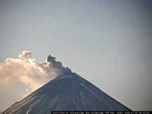
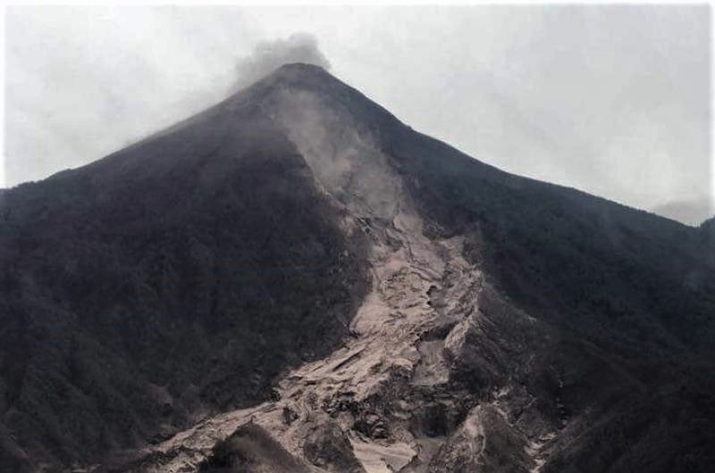
Insivumeh reported that the Fuego Volcano continues to experience weak to moderate explosions that generate avalanches of the same magnitude, added to ash columns at an elevation of 4,700 meters.
He warns of the rain that arrived Tuesday night. It is possible that during the first hours of Wednesday, there are raids of lahars. The danger is greater for the INSIVUMEH is the transport of hot materials, stones up to a meter in diameter, tree trunks and anything that can be dragged by the current.
It warns about risk for communities located on the edge of the volcano’s southern ravines. Insivumeh estimates that another precipitation event is not necessary for these landslides to occur, since Tuesday’s rain will have accumulated enough for this phenomenon.
In the bulletin they also confirm that the activity of the volcano continues, so it is not excluded that the descent of new pyroclastic flows ravines, this alert concerns the hours and days to come.
« It is recommended not to stay near the affected area, inside the ravines or their surroundings ».
Air Transport:
The Insivumeh recommends to the General Directorate of Civil Aviation to take precautions with air traffic due to ash at a height of 15 thousand 420 feet, in direction West and North-East, in addition to the variations of the wind which can occur during the day.
SPECIAL BEFGO VULCANOLOGICAL BULLETIN # 42-2018 Guatemala 06 June 2018, 17:20 (local time)
DESCENT OF STRONG LAHARES IN THE RAVINES OF SANTA TERESA, MINERAL AND TANILUYÁ
The recordings of the GR3 seismic station, at present, show the descent of new lahar in the ravines of Santa Teresa, Mineral and Taniluyá, tributaries of the Pantaleon River and the conditions are generated for the same phenomenon in the Honda ravine. These lahars are the result of rain and accumulation of matter due to the recent activity of the Fuego volcano.
These lahars have a size of about 30 meters wide in some places and reach 2 to 3 meters high, they are hot, and during their descent it emanates vapors, they carry a mud similar to concrete, rocks of 2 At 3 meters in diameter, trunks and trees are dragged by the current, mainly affecting the communities on the banks of the ravines and the Pantaleón bridge.
It is possible that due to expected rainfall in the region, in the hours that will come, there are new lahares in these or one of the main canyons.
Source : Prensa libre , Insivumeh .
Photo : NotiGraficoSacatepequez, reseauparisnanterre.
Pacaya , Guatemala :
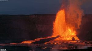
A flow of lava was released around 10:00 from the north side of the Pacaya volcano.
INSIVUMEH indicates that this activity is typical of Pacaya and has neither a relationship nor a consequence of the recent eruption of the Fuego Volcano.
The ban on crater climbing continues and relevant measures are being taken to prevent tourists from approaching the lava flows.
Surveillance is maintained. We will continue to inform.
https://www.facebook.com/parquenacionalvolcanpacaya.pacaya/videos/2006666329366915/
Due to weather conditions, there is no good visibility at this time. The PCG seismic station records internal tremors as a result of constant outgassing and occasional small explosions.
Source : Parque Nacional , Insivumeh.
Lascar , Chile :
During this first period, a total of 88 seismic events were recorded, 57 of which were classified as volcano-tectonic earthquakes (VT), associated with rigid material failure processes. The most powerful earthquake had a local magnitude (ML) of 1.6 and was located 0.5 km northeast of the active crater at a depth of 3.5 km.
Similarly, 16 so-called long-lived earthquakes (LPs) have been recorded in relation to the dynamics of fluids inside the volcano, with reduced displacement values (DRC) of less than 1.2 cm2. Finally, 15 long-lived earthquakes called « Tornillos » were recorded, associated with the resonance of magmatic and / or hydrothermal fluids inside the volcanic ducts, with reduced displacement values (DRC) of, 2 cm2 .
The images obtained by the IP camera showed degassing from the main crater, reaching a maximum height of nearly 1600 m above the level of the active crater.
From the data of three (3) GNSS stations located on the volcano, it was observed that the deformation in the PUNA station, reported during the previous period has ceased. This one is in stability in all its components, therefore no evidence is observed in the deformation for the observed period.

Sulfur dioxide (SO2) emissions recorded by Differential Absorption Spectrometry (DOAS) show an average value in the first half of 1243 ± 157 t / day and a daily maximum of 3260 t / day, reported on 10 may. S02 emissions are at moderate to high levels for this volcano, reflecting a similar trend from previous periods.
No thermal warning has been reported, associated with the volcano region, according to data processed by infrared, means of observation of volcanic activity (Mirova) (http://www.mirovaweb.it/).
During this period, it continued to record a shallow seismic activity, which in earlier periods had been associated with minor phreatic eruptions, particularly in the years 2013 and 2015, in relation to the simultaneous occurrence of VT-type earthquakes and of type « Tornillos », with no incandescence that normally, we observe, suggesting a small obstruction of the column of magma located at shallow depths. Despite the fact that seismicity keeps energy levels considered low, it is envisaged that the current level of activity will increase the possibility of minor explosions.
As a result, the level of volcanic alert remains at the level:
YELLOW LEVEL: Changes in the behavior of volcanic activity – Probable time for an eruption: WEEKS / MONTH.
Observation: Consider a 2-kilometer zone around the active crater as a danger zone.
Source : Sernageomin .
Source : Sernageomin .
Taupo , New Zealand :
Earthquake swarms near Kawerau and Taupo
Published: Wed Jun 6 2018 8:50 AM
Earthquake swarms are typical of the earthquake activity in the Rotorua-Taupo area, the Taupo Volcanic Zone. In the last week they have occurred near Kawerau and Taupo.
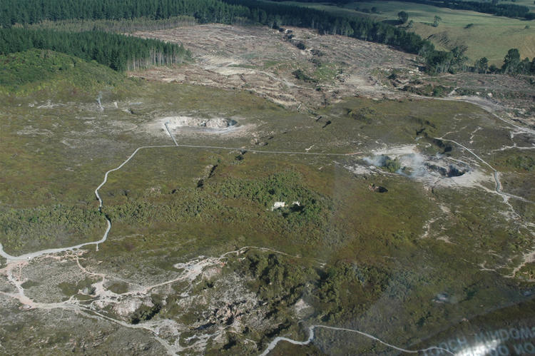
Crater of the moon , Taupo .
In the last week there have been two swarms of small earthquakes located near geothermal systems. A small one near Taupo (Rotokawa geothermal system) and a slightly larger one at Kawerau. Both are large geothermal systems and local earthquakes are common.
On Thursday May 31 GeoNet located 9 earthquakes near the Rotokawa geothermal area. Their magnitudes ranged from about M 1.5 to M 2.5, while the depths ranged between 9 and 6 km.
The swarm in the Kawerau area is larger and also started around May 31, with more events on June 2 and 5. The magnitudes ranged from about M 1.5 to M 1.9, while the depths ranged between 5 and 6 kilometres for the events on May 31 and June 2. Then overnight June 5 two further phases of swarm activity occurred at Kawerau. In the first phase from 6 to 10 pm we located 54 events, the depths ranged 4 to 12 km and the magnitudes from 0.9 to 3.8. The largest was at 7.22 pm. The second phase after 10 pm consisted of 41 events. The depths ranged 2 to 8 km and the magnitudes from 1.8 to 4.1. The largest was at 8.14 pm.
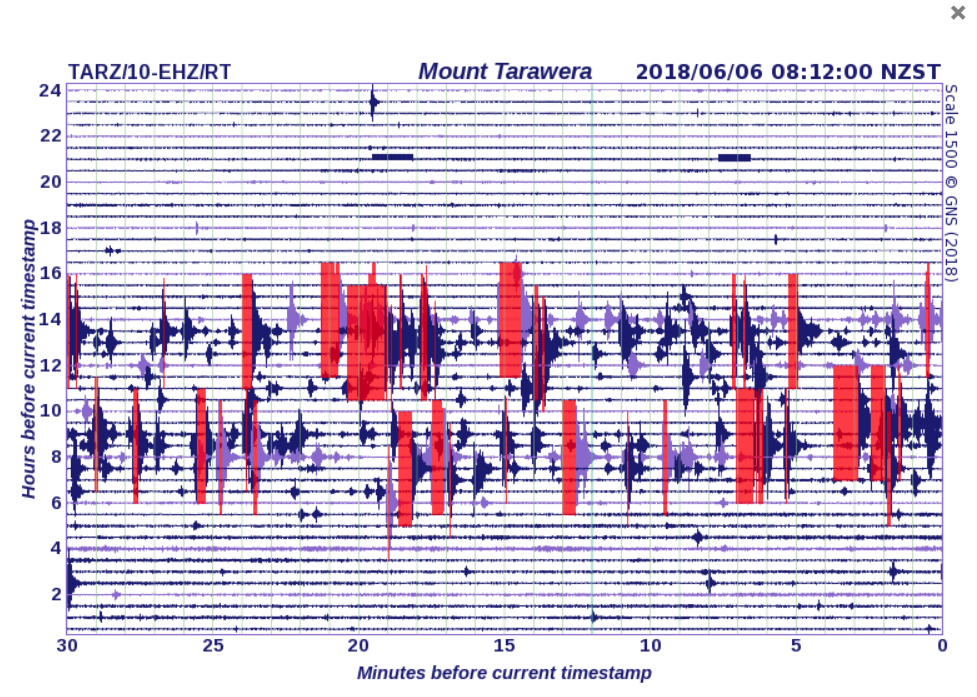
Seismic record showing the two phases of swarm activity near Kawearu
The quakes are likely to be related to the long-term tectonic stretching of the Taupo Volcanic Zone. Swarms are o
Source : Geonet