27 Mars 2025.
Hawaii , Kilauea :
Wednesday, March 26, 2025, 10:45 AM HST (Wednesday, March 26, 2025, 20:45 UTC)
19°25’16 » N 155°17’13 » W,
Summit Elevation 4091 ft (1247 m)
Current Volcano Alert Level: WATCH
Current Aviation Color Code: ORANGE
Activity Summary:
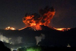
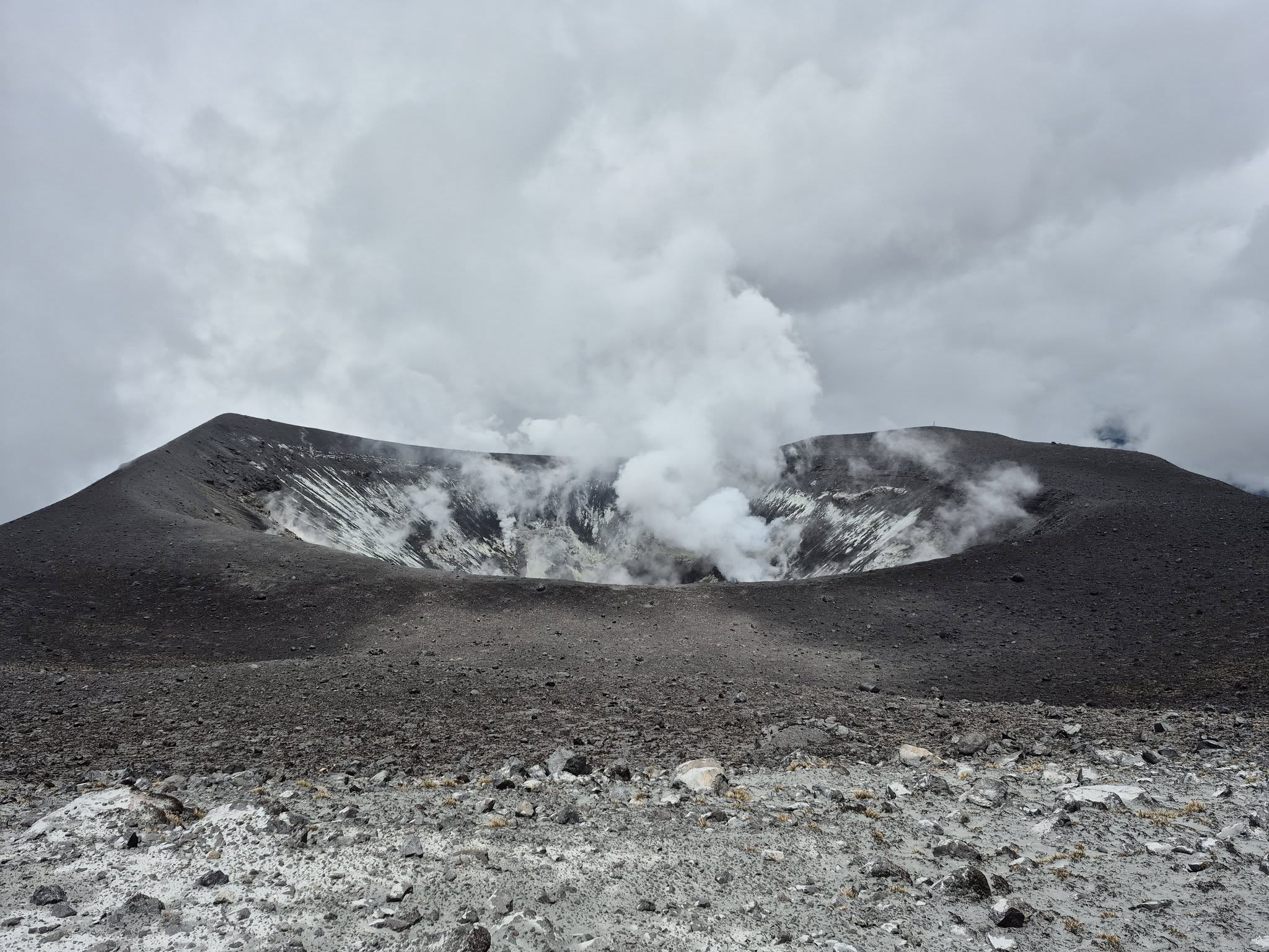
Episode 15 of the ongoing Halemaʻumaʻu eruption began at 12:04 HST on March 25 with cyclic lava spatter and flows, followed by the onset of sustained high fountains from both the north and south vents at 10:20 a.m. HST March 26. Currently fountains are in excess of 600 feet (180 meters) high.
Episode 15 fountaining was preceded by over 100 cycles of lava rise and fall, vent overflows, and spatter fountains in the north vent, a phenomenon known as ‘gas pistoning’, which has been observed in other eruptions at Kīlauea in recent decades.
At 10:00 a.m. HST today, gas pistoning began transitioning to lava fountaining. At the time of this update, the tallest fountains from the south vent exceeded 600-700 feet (180-210 meters) high with north vent fountains generally less than half as high.
Inflationary tilt on SDH reached just over 6 microradians since the end of the last episode, recovering more than 100% of the tilt lost from episode 14. Seismic tremor began increasing and decreasing with the cyclic fountains and drainback. At the initiation of fountaining around 10:00 a.m. HST, tilt at SDH switched from inflation to deflation; at the same time, tremor increased and became sustained.
Emissions of SO2 gas during episodes 13 and 14 have exceeded 40,000 tonnes per day and similar levels of SO2 emission are expected to accompany the high fountains of episode 15. Winds at the summit are forecast to be weak over the next day, which may allow the eruptive gas plume to spread around the summit region of Kīlauea. In addition, visitors to Hawaiʻi Volcanoes National Park and residents of adjacent towns may be exposed to Pele’s hair and other small fragments of volcanic glass being carried by the plume.
Each episode of Halemaʻumaʻu lava fountaining since December 23, 2024, has continued for at least 13 hours, and up to 8 days, and episodes have been separated by pauses in eruptive activity lasting less than 24 hours to 12 days.
No changes have been detected in the East Rift Zone or Southwest Rift Zone. HVO continues to closely monitor Kīlauea and will issue an eruption update tomorrow morning unless there are significant changes before then.
Activity Summary:
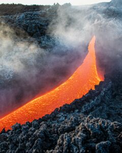
Episode 15 of the ongoing Halemaʻumaʻu eruption ended at 7:10 p.m. HST on March 26 when fountaining at the south vent stopped. North vent fountains had ceased activity earlier, around 12:00 p.m. HST. Overall, episode 15 lasted just over 31 hours with the last 9 hours consisting of high fountains predominantly from the south vent.
Initial activity from episode 15 included cycles of gas pistoning for roughly 24 hours, followed by fountains from both vents. The transition to high fountains began just after 10:00 a.m. HST today, with early fountain heights growing rapidly in the first 30 minutes to greater than 600 feet (180 meters) high. Later fountaining reached maximum heights over 1,000 feet (305 meters).
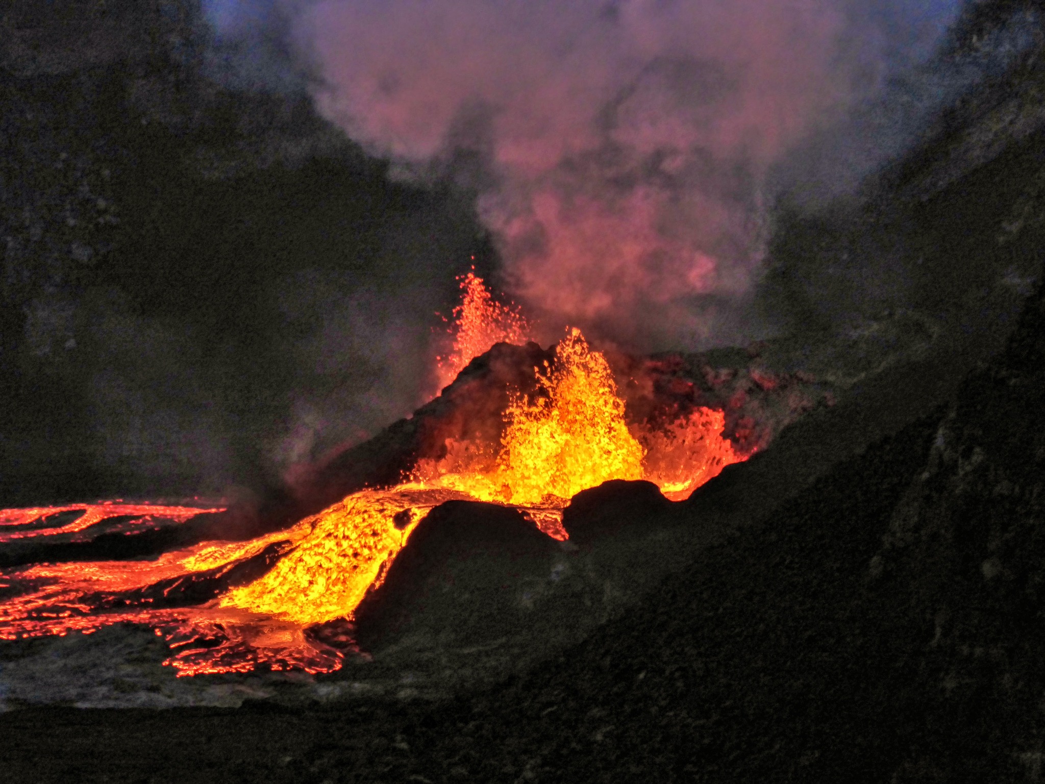
Fountain heights were higher in episode 15 than in previous episodes, continuing the pattern of fountain growth with time. Fountaining reached maximum heights just over 1,000 feet (305 meters) between 11:00 a.m. and 12:00 p.m. and again around 1:30 p.m. HST. Fountain heights in excess of 600-800 feet (180-250 meters) occurred sporadically through the rest of the episode, with more sustained fountaining at somewhat lower heights of roughly 600 feet (180 meters). Just after 1:30 p.m. HST, the south vent fountain began to incline, or bend over, with fountaining directed toward the southeast. The directed/inclined fountaining reappeared intermittently through the afternoon hours, with a maximum inclination approaching 45 degrees. By 5:30 p.m. HST the south vent fountains became vertical again with sustained heights of 500-700 feet (150-215 meters).
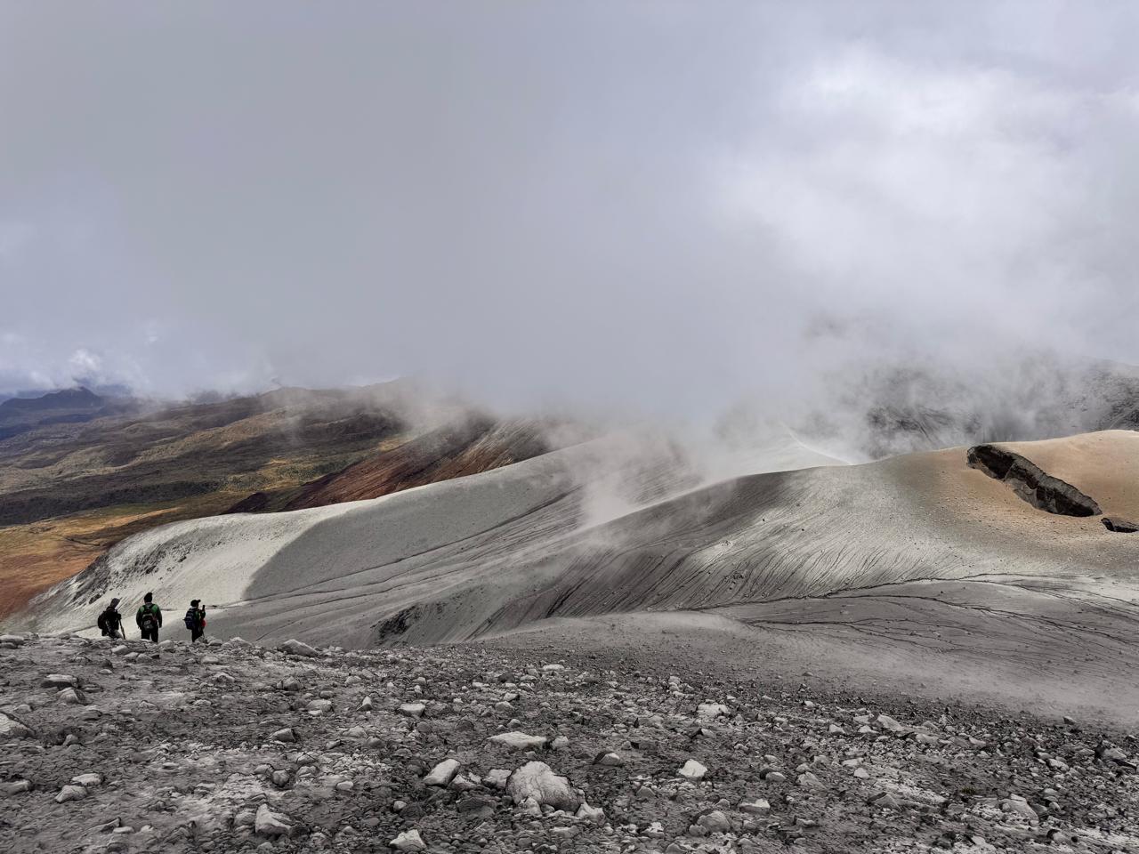
During episode 15, lava flows covered about 80-90% of the floor of Halemaʻumaʻu within the southern part of Kaluapele (Kīlauea caldera). Weak winds also resulted in deposition of Pele’s hair and tephra in public areas of Hawai’i Volcanoes National Park and in populated areas near Kīlauea summit.
The UWD tiltmeter recorded just under 9 microradians of deflation during episode 15, with just under 7 microradians lost on the SDH tiltmeter. Initial deflation was very rapid, but slowed when north vent fountains ceased fountaining around noon. The end of the eruption was coincident with a rapid change in tilt from deflation to inflation at the summit and a decrease in seismic tremor intensity when the fountains ceased at 7:10 p.m. HST.
Source : HVO
Photos : Volcano Hideaways .
Indonesia , Lewotobi Laki-laki :
The Pusat Vulkanologi dan Mitigasi Bencana Geologi (PVMBG) reported increased activity at Lewotobi Laki-laki during mid-March, culminating in a more intense phase on 20 March. Visual observations during 8-15 March indicated that the average height of emissions was increasing with white-to-gray ash plumes rising as high as 2.5 km above the summit. Seismic signals indicating emissions slightly increased, harmonic tremor fluctuated, the number of deep volcanic earthquakes and low-frequency earthquakes slightly decreased, though there was a slight increase in the number of deep volcanic earthquakes on 13 March. No shallow volcanic earthquakes were detected. Crater incandescence was visible on 13 March.
Activity significantly increased during 13-20 March. Daily gray ash plumes continued to rise as high as 2.5 km above the summit, though the average height of plumes had increased. Harmonic tremor continued to fluctuate and the number of low-frequency earthquakes slightly increased. A tornillo-type earthquake was detected on 16 March. The number of deep volcanic earthquakes increased significantly during 19-20 March totaling 205 compared to the average of 3-6 events per day. Shallow volcanic earthquakes began to be detected on 20 March indicating rising magma. Eruptive activity continued to intensify; in response PVMBG raised the Alert Level to 4 (on a scale of 1-4) at 22h30 on 20 March and increased the exclusion zone to a radius of 7 km from the center of Laki-laki and 8 km in a semicircle clockwise from the SW to the NE. BNPB reported that residents were evacuated from several villages during 19-20 March including Pululera Village (8 km NW), Dulipali Village (6 km NNW), Padang Pasir (5 km NW), Nobo (5 km NE), Klatanlo (3 km NW), Hokeng Jaya (4 km NW), Boru (8 km WNW), and Nawakote.
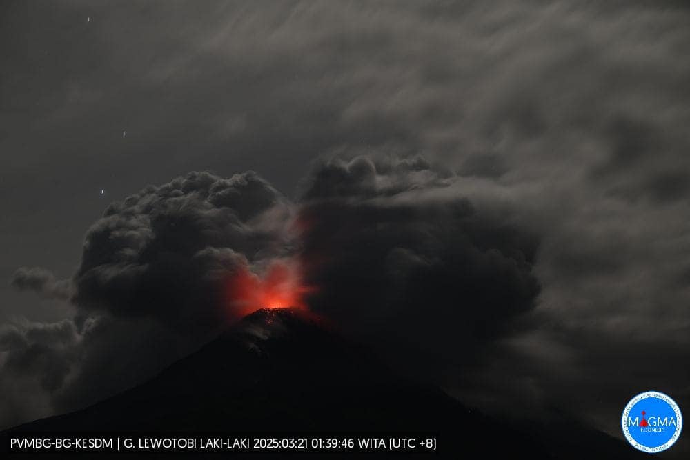
Incandescence at the summit and possibly low on the NW flank was visible in a webcam image starting at 22h45 on 20 March. An explosion at 22h56 was recorded by several monitoring stations in Flores and heard in areas as far as Maumere City (63 km WSW) and Larantuka (35 km NE). The corresponding seismic signals lasted 11 minutes and nine seconds. A gray-to-black ash plume rose 8 km above the summit and drifted SW and W. According to the Darwin VAAC an ash plume was identified in a satellite at 23h40 drifting W at an altitude of 16.1 km (53,000 ft) a.s.l., or 14.5 km above the summit. Dense gray ash plumes rose 2.5 km and 700 m above the summit and drifted W and N and NE at 00h10 and 01h22 on 21 March, respectively, according to PVMBG. BNPB reported that tephra fell in several surrounding areas. By 03h00 the VAAC noted that the plume had detached from the summit and continued to drifted W. Lower-level ash emissions, at 6.1 km (20,000 ft) a.s.l., 4.4 km above the summit, drifted SE. Ash plumes continued to be identified in satellite images during 06h00-09h00; ash at 3-6.1 km (10,000-20,000 ft) a.s.l., 1.3-4.4 km above the summit, drifted SE and ash at 12.2 km (40,000 ft) a.s.l., 10.5 km above the summit, drifted SWW. The high-level ash plume at 16.1 km a.s.l. continued to drift W but was beginning to be obscured by weather clouds by 10h00. Eruptive events were recorded at 14h13 on 21 March, at 19h16 on 22 March, at 04h45 on 23 March, and at 02h22 on 25 March, though weather clouds and/or darkness obscured views.
According to news reports and BNPB, two people suffered from burns but there were no fatalities during the 20-21 March eruption; around 4,000 people that had evacuated months earlier remained in temporary housing. News articles also noted that 16 international flights to and from the Ngurah Rai International Airport were cancelled, others were delayed, and some domestic flights were postponed.
Sources: Pusat Vulkanologi dan Mitigasi Bencana Geologi (PVMBG, also known as CVGHM), Badan Nacional Penanggulangan Bencana (BNPB), Darwin Volcanic Ash Advisory Centre (VAAC), Antara News, Antara News, Antara News, Antara News , GVP.
Photo : Magma Indonésie .
Tonga Islands , Home Reef :
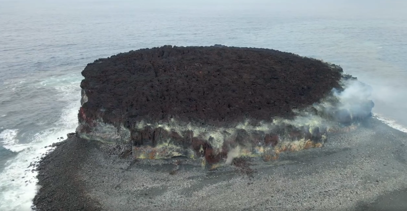
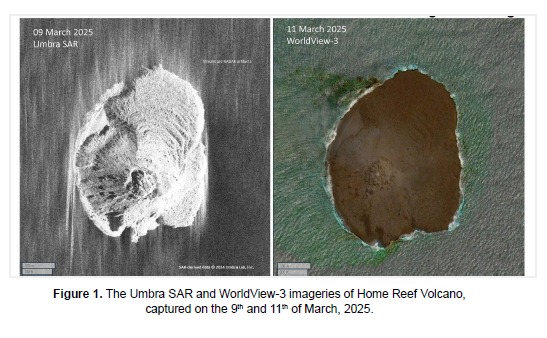
The Tonga Geological Services reported ongoing and consistent activity at Home Reef during 11-21 March. A lava dome just SW of the central part of the island was visible in an 11 March satellite image; this 80 m W-E, 100 m N-S feature had not changed in size since the previous view. Thermal anomalies were ongoing at least through 19 March and were at mostly low levels, though occasionally they were characterized as moderate.
Infrasound data also indicated continuing minor eruptive activity. The Maritime Alert Level remained at Orange (the third level on a four-level scale), and mariners were advised to stay at least 2 nautical miles (3.7 km) away from the island. The Aviation Color Code remained at Yellow (the second level on a four-level scale), and the Alert Level for residents of Vava’u and Ha’apai remained at Green (the first level on a four-level scale).
Home Reef, a submarine volcano midway between Metis Shoal and Late Island in the central Tonga islands, was first reported active in the mid-19th century, when an ephemeral island formed. An eruption in 1984 produced a 12-km-high eruption plume, large amounts of floating pumice, and an ephemeral 500 x 1,500 m island, with cliffs 30-50 m high that enclosed a water-filled crater. In 2006 an island-forming eruption produced widespread dacitic pumice rafts that drifted as far as Australia. Another island was built during a September-October 2022 eruption.
Sources: Tonga Geological Services, Government of Tonga , GVP
Photos : Lacelid Productions ( capture d’écran ) , SAR / Worldview.
Colombia , Puracé – Los Coconucos volcanic chain :
Popayán, March 25, 2025, 4:00 p.m.
According to monitoring of the activity of the Puracé Volcano – Los Coconucos Volcanic Chain, the Colombian Geological Survey (SGC), an entity affiliated with the Ministry of Mines and Energy, reports that:
During the week of March 18-24, seismic activity associated with rock fracturing was mainly located beneath the Puracé volcanic edifice, at depths ranging from 1 to 3 km, with a maximum recorded magnitude of 1.7. Fluid dynamic events were located at depths less than 2 km, particularly beneath the crater of the Puracé Volcano.
Moderate sulfur dioxide (SO2) and carbon dioxide (CO2) emissions were recorded using field and satellite instruments. The slow process of deformation continues between the volcanic edifices of Puracé, Piocollo and Curiquinga.
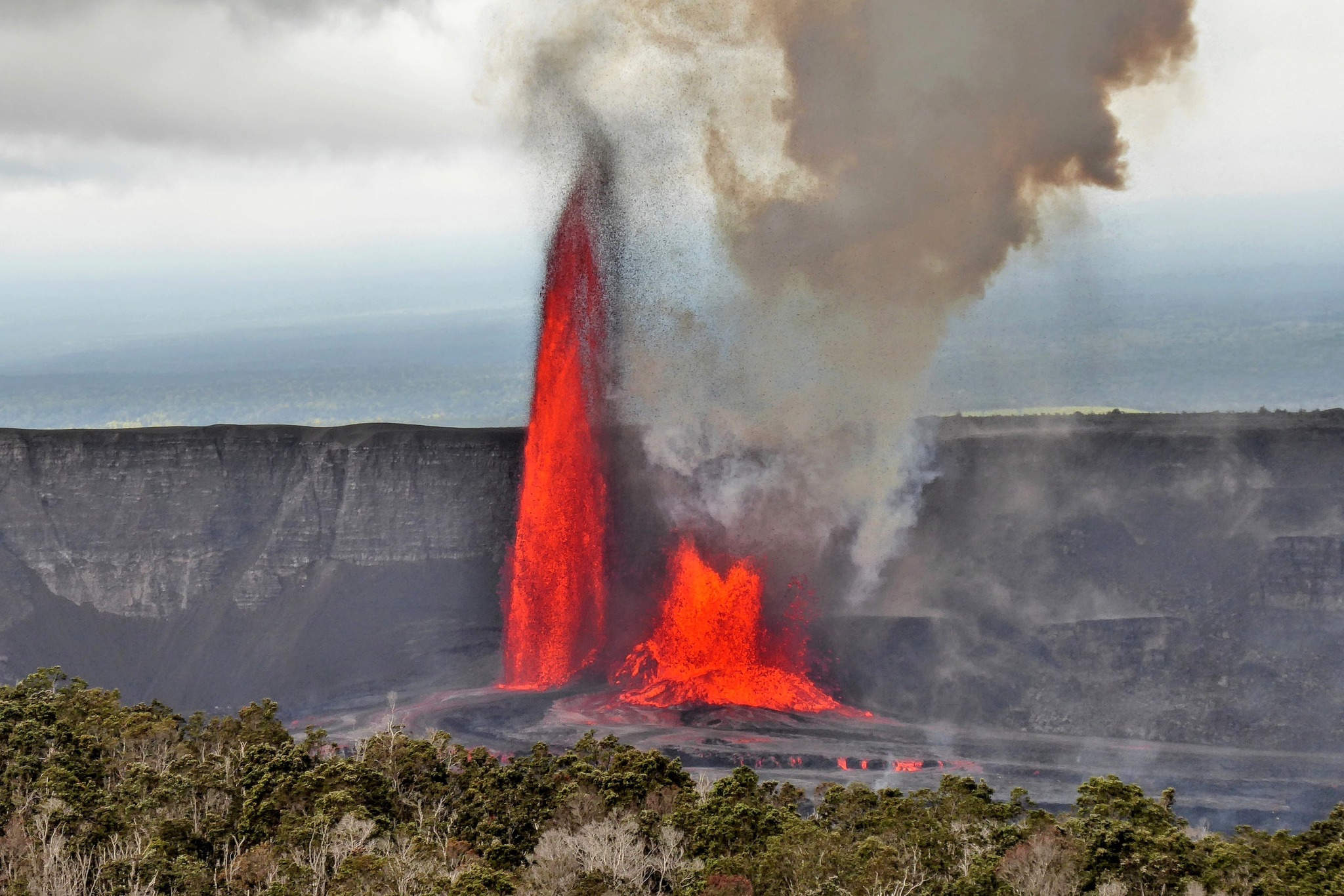
Images captured by visible and infrared webcams showed degassing processes in the lateral fumarole and within the crater of Puracé Volcano.
It is concluded that degassing continues in the lateral fumarole and crater of Puracé Volcano, accompanied by seismic activity beneath the volcano’s edifice, slow changes in deformation, and surface thermal anomalies.
Under yellow alert status, phenomena such as sporadic ash emissions (minor eruptions of limited magnitude and effect, whose dispersion depends on wind direction), the presence of incandescence, small explosions in the crater, low-energy thermal anomalies, noise, felt earthquakes, odors, precipitation of elemental sulfur near the crater and in hot springs and fumaroles, as well as degassing in different areas of the crater may occur. The formation of fissures and the appearance of minor lahars, among others, are also observed.
Based on the above, the SGC recommends closely monitoring the evolution of volcanic activity through weekly bulletins and other information published on official channels, as well as heeding the instructions of local and departmental authorities and the National Disaster Risk Management Unit (UNGRD).
The alert status for volcanic activity remains at yellow alert: active volcano with changes in the behavior of the baseline level of monitored parameters and other manifestations.
Source et photos : SGC
Japan , Sakurajima :
The Japan Meteorological Agency (JMA) reported ongoing eruptive activity at Minamidake Crater (Aira Caldera’s Sakurajima volcano) during 17-24 March. Nightly crater incandescence was visible in webcam images. Very small eruptive events were periodically recorded during 17-21 March. An explosion at 02h01 on 22 March generated an ash plume that rose 600 m above the crater rim and drifted SE. The explosion ejected large blocks 600-900 m from the vent. An eruptive event at 05h55 on 23 March generated an ash plume that rose 1.8 km above the crater rim and drifted SE. The Alert Level remained at 3 (on a 5-level scale), and the public was warned to stay 2 km away from both the Minimadake and Showa craters.
.

The Aira caldera in the northern half of Kagoshima Bay contains the post-caldera Sakurajima volcano, one of Japan’s most active. Eruption of the voluminous Ito pyroclastic flow accompanied formation of the 17 x 23 km caldera about 22,000 years ago. The smaller Wakamiko caldera was formed during the early Holocene in the NE corner of the caldera, along with several post-caldera cones. The construction of Sakurajima began about 13,000 years ago on the southern rim and built an island that was joined to the Osumi Peninsula during the major explosive and effusive eruption of 1914. Activity at the Kitadake summit cone ended about 4,850 years ago, after which eruptions took place at Minamidake. Frequent eruptions since the 8th century have deposited ash on the city of Kagoshima, located across Kagoshima Bay only 8 km from the summit. The largest recorded eruption took place during 1471-76.
Sources: Japan Meteorological Agency (JMA), GVP.
Photo : Webcam