January 13 , 2019.
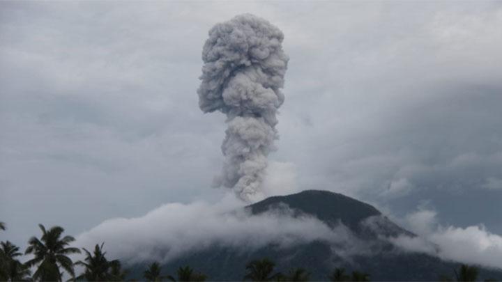
Russia / Kamchatka , Sheveluch :
VOLCANO OBSERVATORY NOTICE FOR AVIATION (VONA).
Issued: January 13 , 2019
Volcano:Sheveluch (CAVW #300270)
Current aviation colour code:ORANGE
Previous aviation colour code:orange
Source:KVERT
Notice Number:2019-16
Volcano Location:N 56 deg 38 min E 161 deg 18 min
Area:Kamchatka, Russia
Summit Elevation:10768.24 ft (3283 m), the dome elevation ~8200 ft (2500 m)
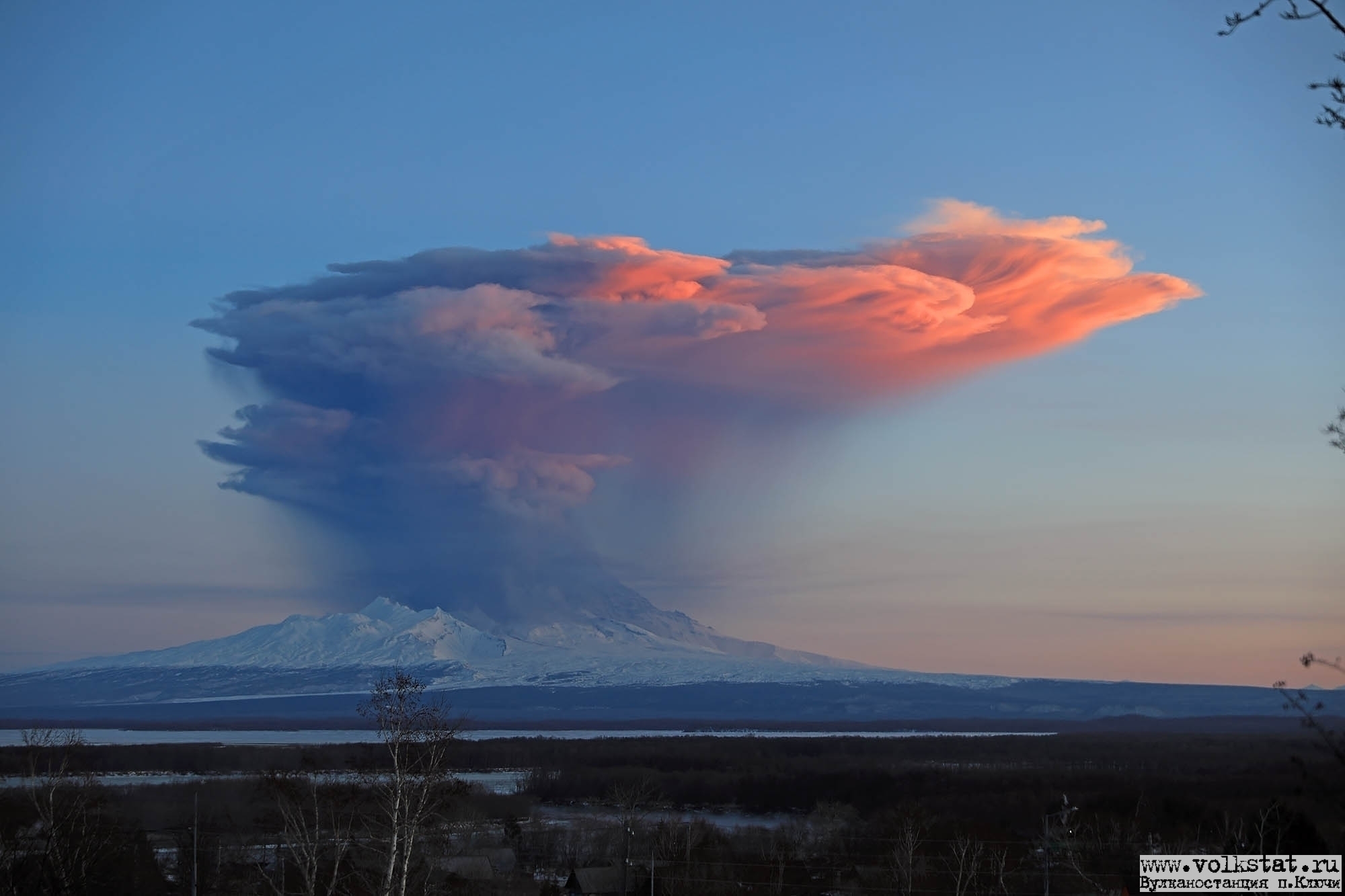
Volcanic Activity Summary:
A growth of the lava dome continues (a viscous lava blocks extrude out on the northern part of it), a strong fumarolic activity and an incandescence of the dome blocks and hot avalanches accompanies this process. According to satellite data, a strong gas-steam plume with some amount of ash on the height 5.5-6.0 km a.s.l. continues to drift to the west-southwest from the volcano.
Explosive-extrusive eruption of the volcano continues. Ash explosions up to 32,800-49,200 ft (10-15 km) a.s.l. could occur at any time. Ongoing activity could affect international and low-flying aircraft.
Volcanic cloud height:
18040-19680 ft (5500-6000 m) AMSL Time and method of ash plume/cloud height determination: 20190113/0150Z – Himawari-8
Other volcanic cloud information:
Distance of ash plume/cloud of the volcano: 16 mi (25 km)
Direction of drift of ash plume/cloud of the volcano: WSW / azimuth 245 deg
Time and method of ash plume/cloud determination: 20190113/0150Z – Himawari-8
Source : Kvert.
Photo : Y. Demyanchuk / volkstat ru ( 05/12/2017).
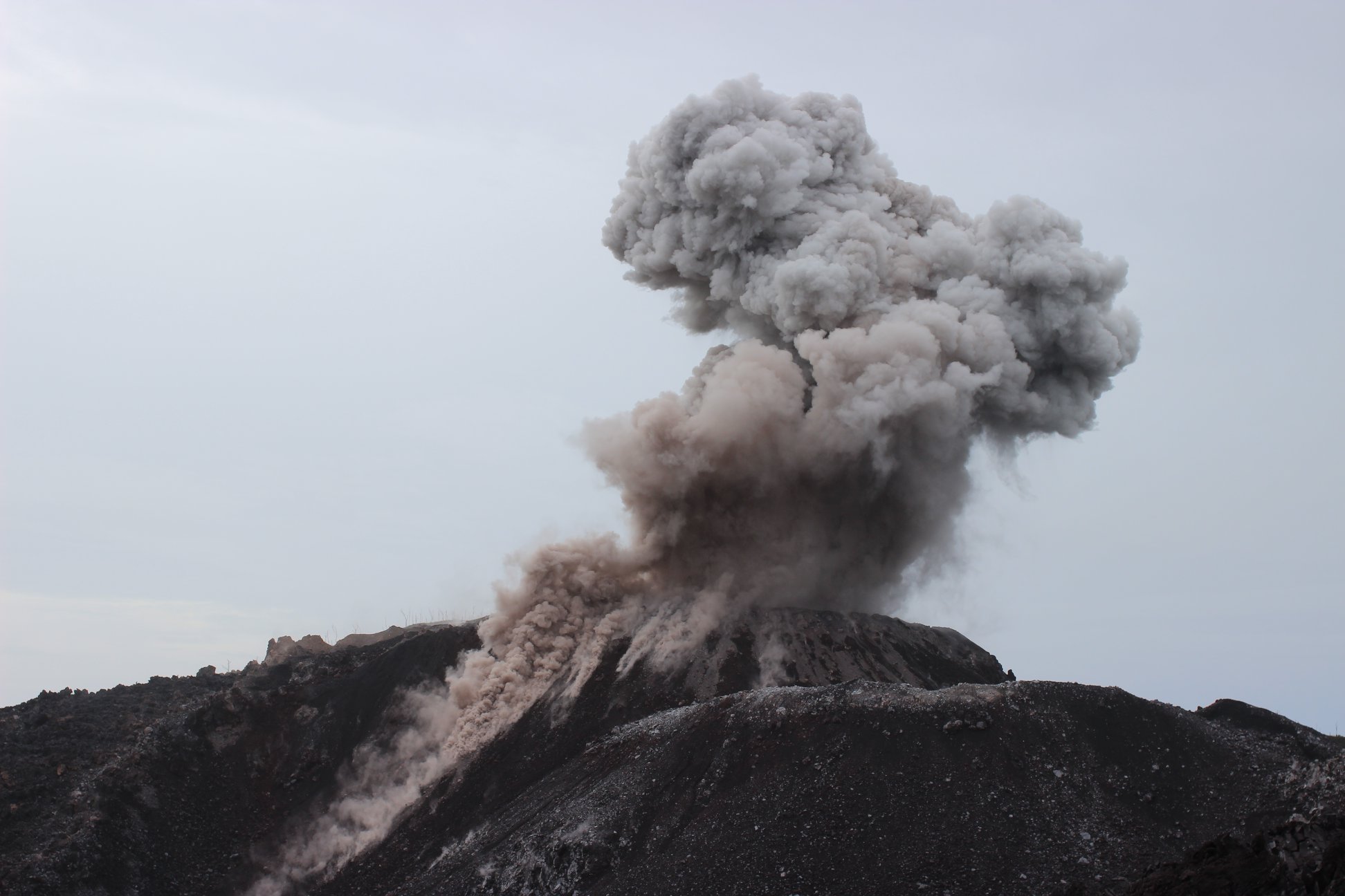
Indonesia , Ibu :
Level II Activity Level (WASPADA). The volcano IBU (1340 m of altitude) has been continuously erupting since 2008.
Since yesterday and until this morning, the vision of the volcanic peak was clear until it was covered with fog. It was observed smoke from the crater with a height of about 200-800 meters, gray color and low pressure. The wind is blowing weakly to moderately to the south.
The seismographs, on January 12, 2019, recorded:
81 earthquakes of eruption
68 earthquakes emission
25 avalanche earthquakes
4 Tornillo earthquakes
13 harmonic tremors.
3 distant tectonic earthquakes
Recommendation: Communities around G. IBU and visitors / tourists should not have activities, go up or approach within 2 km. The sectoral expansion is 3.5 km towards the openings in the northern part of G. IBU’s active crater.
VOLCANO OBSERVATORY NOTICE FOR AVIATION – VONA.
Issued: January 12 , 2019
Volcano: Ibu (268030)
Current Aviation Colour Code: ORANGE
Previous Aviation Colour Code: unassigned
Source: Ibu Volcano Observatory
Notice Number: 2019IBU01
Volcano Location: N 01 deg 29 min 17 sec E 127 deg 37 min 48 sec
Area: North Maluku, Indonesia
Summit Elevation: 4240 FT (1325 M)
Volcanic Activity Summary:
Eruption with volcanic ash cloud at 23h01 UTC (08h01 local).
Volcanic Cloud Height:
Best estimate of ash-cloud top is around 6800 FT (2125 M) above sea level, may be higher than what can be observed clearly. Source of height data: ground observer.
Other Volcanic Cloud Information:
Ash cloud moving to south.
Remarks:
Seismic activity is characterized by explosion and rock avalanches earthquakes.
Sources : PVMBG , Magma indonesia.
Photos : Tempo.co , Auteur inconnu.
Chile , Chaitén :
During the evaluated period, a total of 13 seismic events were recorded, of which 8 were classified as volcano-tectonic (VT) type, associated with rock fracturing processes. The event of greatest energy had a local magnitude (ML) equal to M 0.1, and was located west of the dome center at a depth of 7.7 km. Also, 1 long period type (LP) earthquakes were recorded in relation to fluid dynamics within the volcanic edifice, which had a reduced displacement value (DRc) of 5.8 cm2. Finally, a Hybrid-type seismic event (HB) is recorded in relation to a complex mechanism (fracturing process of rigid materials and fluid dynamics inside the volcanic edifice) with a reduced displacement value (DRc). equal to 1.5 cm2.
The occurrence of three tremor-type earthquakes (TR) is noted in relation to the transit of fluids within the volcanic edifice. The higher energy event had a reduced displacement value (DRc) equal to 0.8 cm2.
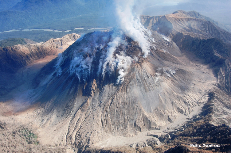
The images provided by the IP cameras installed around the volcano, when the weather conditions allowed it, showed a superficial activity of a maximum height of 50m and an incandescence during the night.
No sulfur dioxide (S02) emissions have been reported in the area’s atmosphere near the volcanic building, according to data published by the Ozone Observatory Sulfur Dioxide Group (http: // mon2.gsfc.nasa.gov/). ) and the National Information and Satellite Data Service on the Environment (NESDIS) (http://satepsanoine.nesdis.noaa.gov).
6 thermal warnings were reported in the area associated with the volcanic complex during the period, with a maximum PVR of 1 MW, considered low, according to the data processed by the mean infra-red observation. Volcanic Activity (MIROVA) (http://www.mirovaweb.it/) and Temporal Thermal Monitoring of Global Hot Spots (MODVOLC) (http://modis.higp.hawaii.edu/).
The seismicity remains at levels considered weak and suggest a relative stability of the volcanic system.
Because of the above, the volcanic warning is kept at the level:
GREEN LEVEL: Changes in the behavior of volcanic activity – Probable time for an eruption: WEEKS / MONTH.
Source : Sernageomin
Photo : Paty Santini .
Costa Rica , Poas / Rincon de la Vieja :
Daily report on the state of volcanoes. OVSICORI-UNA, Date: January 12, 2019, Updated at: 10:56:00 AM.
Poas Volcano.
Since 19 December 2018, a continuous eruption has been recorded on the Poas volcano, with a column rising 500 meters above the crater and 3208 meters above sea level (10522.24 ft).
The seismic activity is similar to that of yesterday.
At the time of this report, the winds blow towards the West.
The volcano continues with frequent geyser eruptions of low height (less than 20 m). The plume can rise to several hundred meters depending on the weather conditions. The SO2 / CO2 ratio tends to increase.
Rincon de la Vieja Volcano .
On January 12, 2019, at 00:00 local time, there was an eruption on the Rincon de la Vieja volcano, with a column that culminated at 1,000 meters above crater height and 2916 meters above sea level. the sea (9564.48 ft).
Duration of the activity: minutes.
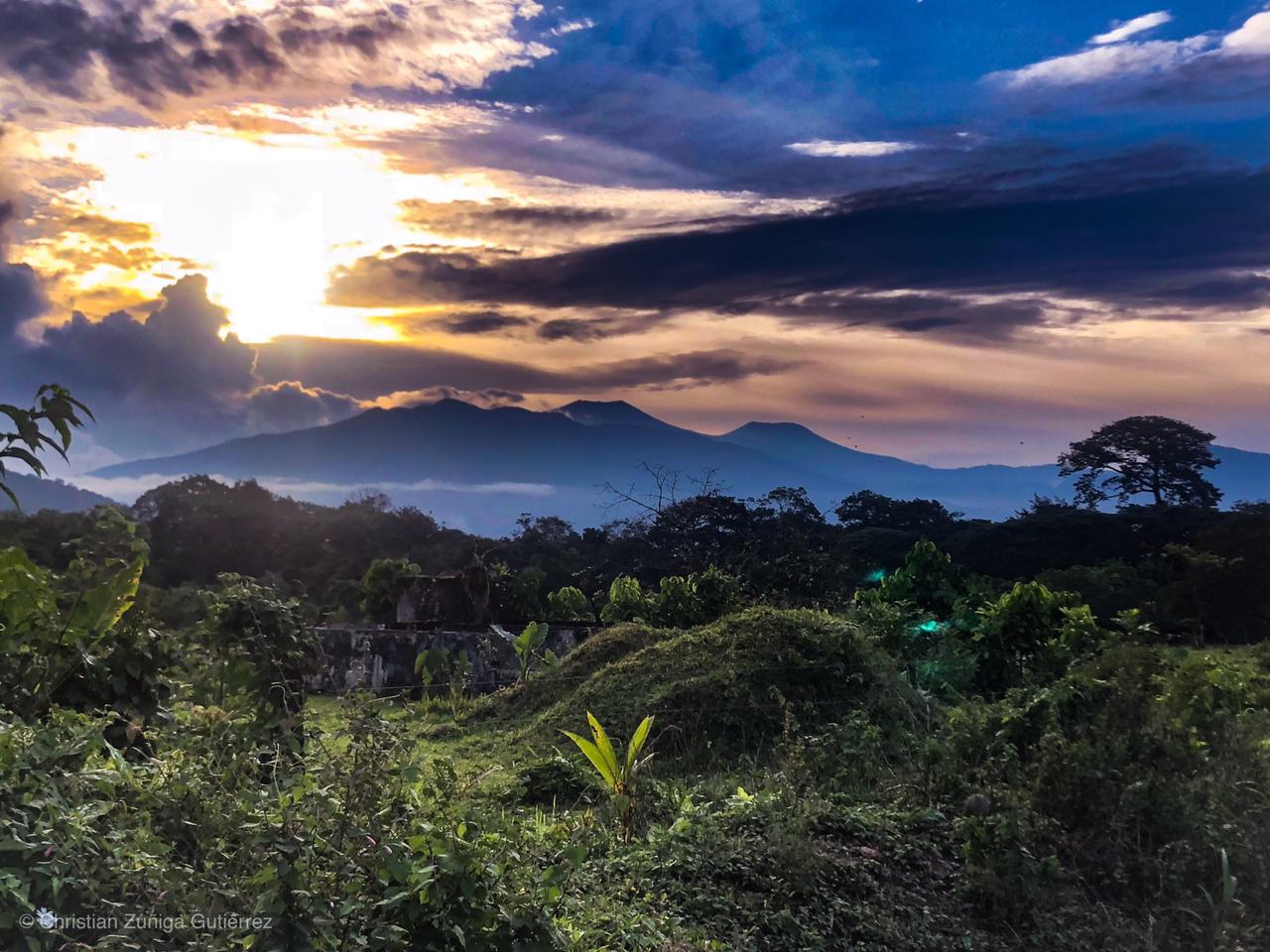
18 October 2018. Photograph by Christian Zúñiga Gutiérrez from Buenos Aires de Upala.
The seismic activity is similar to that of yesterday.
The wind direction is unknown at the moment.
An eruption was recorded at 2:25 pm on January 9, 2019. No direct observations were possible.
Source : Ovsicori.
Photos : Christian Zúñiga Gutiérrez
Video : LookA