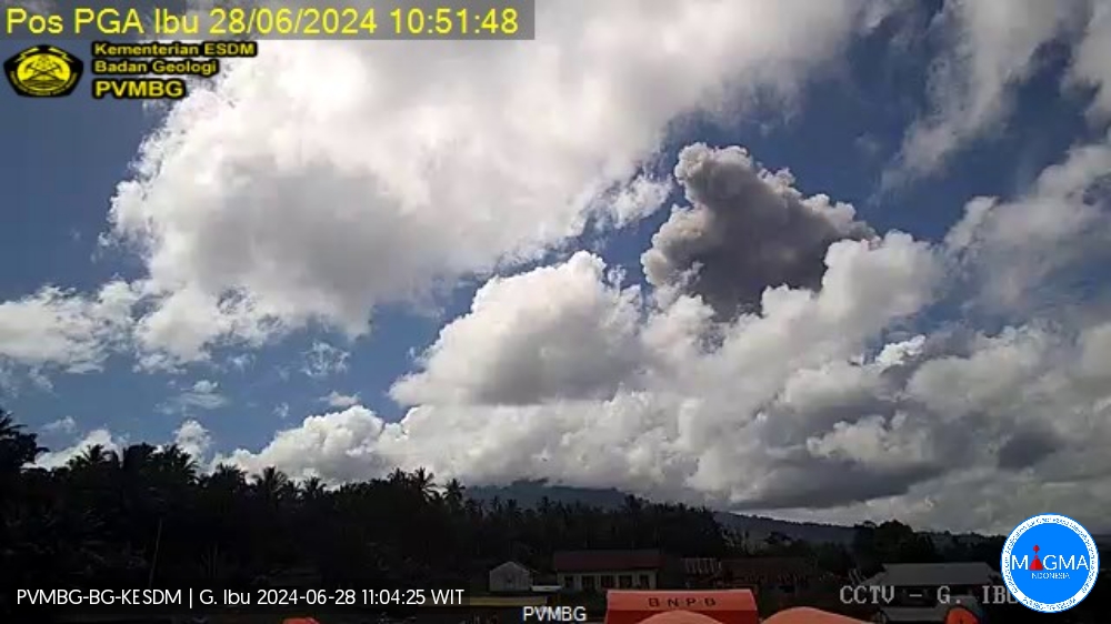
June 28 , 2024.
Indonesia , Ibu :
An eruption of Mount Ibu occurred on Friday, June 28, 2024 at 11:44 a.m. WIT with the height of the ash column observed at ±7,000 m above the summit (±8,325 m above the level of the sea). The ash column was observed to be gray to black in color with thick intensity, oriented towards the South and South-West. At the time of writing, the eruption was still ongoing.
VOLCANO OBSERVATORY NOTICE FOR AVIATION – VONA
Issued : June 28 , 2024
Volcano : Ibu (268030)
Current Aviation Colour Code : RED
Previous Aviation Colour Code : orange
Source : Ibu Volcano Observatory
Notice Number : 2024IBU040
Volcano Location : N 01 deg 29 min 17 sec E 127 deg 37 min 48 sec
Area : North Maluku, Indonesia
Summit Elevation : 4240 FT (1325 M)
Volcanic Activity Summary :
Eruption with volcanic ash cloud at 02h44 UTC (11h44 local).
Volcanic Cloud Height :
Best estimate of ash-cloud top is around 26640 FT (8325 M) above sea level or 22400 FT (7000 M) above summit. May be higher than what can be observed clearly. Source of height data: ground observer.
Other Volcanic Cloud Information :
Ash cloud moving to southwest. Volcanic ash is observed to be gray to dark. The intensity of volcanic ash is observed to be thick.
Remarks :
Eruption recorded on seismogram with maximum amplitude 28 mm and maximum duration 278 second.
Source : Magma Indonésie
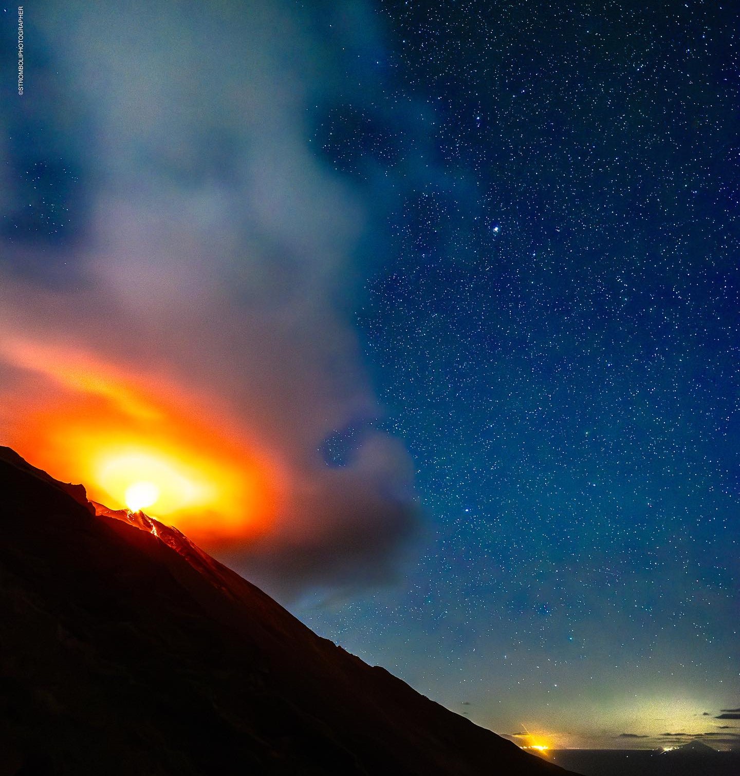
Italy , Stromboli :
Press release on the activity of Stromboli, June 28, 2024, 08:23 (06:23
The National Institute of Geophysics and Volcanology, Osservatorio Etneo, communicates that from around 05:30 UTC we observe the beginning of a small overflow of lava from the area of the North crater, generated by the N1 vent which is affected by intense projection activity. The lava overflow has a length of around a hundred meters and produces the rolling of blocks along the Sciara del Fuoco.
The average amplitude of the volcanic tremor is at high values and has for several days presented an oscillating trend within this class of values with sporadic peaks at very high values. The number of VLP events also presents high values, amounting to approximately 14 events/hour. The signals from the GNSS (HF) and inclinometer deformation monitoring networks do not show significant variations.
Further updates will be communicated shortly.
Source : INGV
Photo : Stromboli stati d’animo / Sebastiano Cannavo.
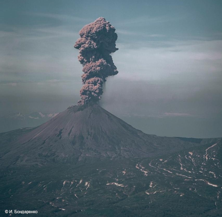
Kamchatka , Karymsky :
VOLCANO OBSERVATORY NOTICE FOR AVIATION (VONA)
Issued: June 28 , 2024
Volcano: Karymsky (CAVW #300130)
Current aviation colour code: ORANGE
Previous aviation colour code: orange
Source: KVERT
Notice Number: 2024-34
Volcano Location: N 54 deg 2 min E 159 deg 26 min
Area: Kamchatka, Russia
Summit Elevation: 1486 m (4874.08 ft)
Volcanic Activity Summary:
The explosive activity of the Karymsky volcano continues. Satellite data by KVERT showed explosions sent ash 2.5 km a.s.l. from the volcano, and an ash cloud is drifting for 32 km to the south of the volcano.
A moderate explosive activity of the volcano continues. Ash explosions up to 10 km (32,800 ft) a.s.l. could occur at any time. Ongoing activity could affect international and low-flying aircraft.
Volcanic cloud height:
2000-2500 m (6560-8200 ft) AMSL Time and method of ash plume/cloud height determination: 20240627/2300Z – Himawari-9 14m15
Other volcanic cloud information:
Distance of ash plume/cloud of the volcano: 32 km (20 mi)
Direction of drift of ash plume/cloud of the volcano: S / azimuth 187 deg
Time and method of ash plume/cloud determination: 20240627/2350Z – Himawari-9 14m15
Source : Kvert
Photo : I. Bondarenko
Colombia , Nevado del Ruiz :
Manizales, June 25, 2024, 6:55 a.m.
Weekly activity bulletin: Nevado del Ruiz Volcano
Regarding the monitoring of the activity of the NEVADO DEL RUIZ VOLCANO, the COLOMBIAN GEOLOGICAL SERVICE (SGC), an entity attached to the MINISTRY OF MINES AND ENERGY, reports that:
In the week of June 18-24, 2024, the volcano continued with unstable behavior. Compared to the previous week, the main variations in the parameters monitored were:
– Seismic activity associated with the fracturing of rocks within the volcanic edifice has maintained similar levels in the number of earthquakes recorded and in the seismic energy released. The earthquakes were located mainly in the Arenas crater and in the South-East and East-South-East sectors of the volcano and, to a lesser extent, in the others, at distances less than 10 km from the crater. Depths of the events varied from less than 1 km to up to 7 km from the volcano summit. The highest magnitude of the week was 1.1, corresponding to the earthquake recorded on June 18 at 11:58 p.m. and located in the crater 2 km deep.

In addition, seismicity linked to the activity of the lava dome (protuberance or mound) located at the bottom of the crater has significantly increased. On June 24, the longest episode and the largest number of events of this type of seismicity have been recorded so far this year. It is also one of the episodes with the longest duration and number of events since 2015, the year in which this type of seismicity was recorded for the first time.
– Seismicity linked to fluid dynamics inside volcanic conduits has increased in the number of earthquakes recorded and in the seismic energy released. The seismic signals exhibited varying energy levels with mostly low to moderate values and sometimes high values. The increase in long-duration seismic signals has also been notable.
Thanks to the cameras used to monitor the volcano and reports from Los Nevados National Natural Park officials and residents in the volcano’s zone of influence, it was possible to confirm several ash emissions associated with some of these seismic events.
The temperature changes of the emitted material were confirmed using FLIR (thermographic) cameras.
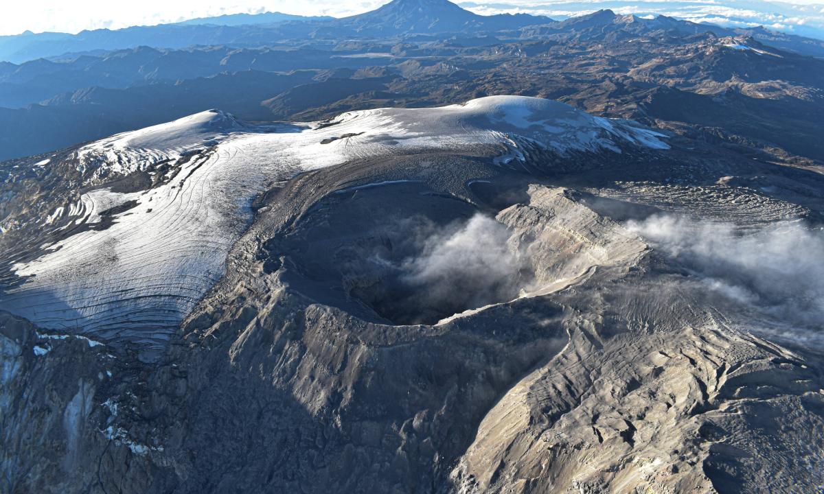
-On the volcano, the emission of water vapor and gas into the atmosphere from the Arenas crater continues.
Sulfur dioxide (SO₂) outgassing rates were variable and maintained levels similar to those recorded the previous week. The maximum vertical height was 1000 m and 1400 m in dispersion of the gas column. These values were estimated at the summit of the volcano on June 19 and 23 respectively. The direction of dispersion of the gas column was variable and presented a preferential trend towards the West of the volcano (from the North-West to the South-West).
– When monitoring surface activity from satellite monitoring platforms, the detection of thermal anomalies at the bottom of Arenas Crater continued to be limited by the heavy cloudiness conditions in the area. However, just this week, reports of detected anomalies were obtained, exhibiting low to moderate energy levels.
Source : SGC
Photos : SGC
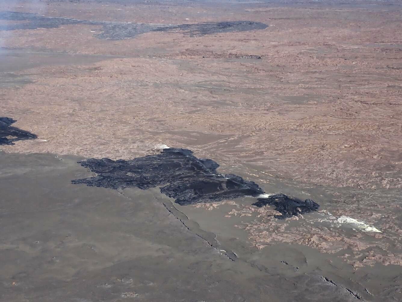
Hawaii , Kilauea :
Thursday, June 27, 2024, 7:42 AM HST (Thursday, June 27, 2024, 17:42 UTC)
19°25’16 » N 155°17’13 » W,
Summit Elevation 4091 ft (1247 m)
Current Volcano Alert Level: ADVISORY
Current Aviation Color Code: YELLOW
Activity Summary:
Kīlauea volcano is not erupting. Earthquake counts and rates of inflationary ground deformation in the summit and upper rift zones continue the moderately elevated behavior that has persisted since the end of the June 3 eruption. Increases in seismicity and/or deformation could result in a new eruptive episode within or near the summit region.
Recent Eruption Site Observations:
Kīlauea erupted briefly on Monday, June 3, southwest of Kaluapele (Kīlauea caldera) within a closed area of Hawaiʻi Volcanoes National Park. Glow from the eruption’s fissure vents is no longer visible in webcam imagery. Seismic activity remains low beneath the eruption site. Sulfur dioxide (SO2) emissions from the eruption site have likely decreased since the most recent measurement of less than 350 tonnes per day on June 10, 2024. Current gas emissions at the eruption site are likely similar to background emission levels at the summit, which are 50–100 tonnes per day. Conditions make it difficult to accurately measure the output from the June 3 fissure vents, but local SO2 concentrations within and near the vents may remain at dangerous levels.
Summit and Upper Rift Zone Observations:
There were approximately 90 earthquakes detected beneath the summit over the past 24 hours, mostly below the south caldera region at depths of 1.5–3 km (1–1.8 mi). The largest event had a magnitude of 2.3, though most events had magnitudes of 2.0 or less. Rates of ground deformation at the summit remained steady over the past day: tiltmeters at Uēkahuna northwest of the summit and at Sand Hill southwest of the summit respectively recorded approximately 5 and 3 microradians of inflation over the past 24 hours. The most recent measurement of the summit’s SO2 emission rate was approximately 50 tonnes per day on June 10, 2024; accordingly, total SO2 emissions from the summit and recent eruption site are likely less than 200 tonnes per day.
Middle and Lower Rift Zone Observations:
Rates of seismicity and ground deformation beneath the middle and lower East Rift Zone and lower Southwest Rift Zone remain low. Recent eruptive activity and ongoing unrest have been restricted to the summit and upper rift zone regions. Measurements from continuous gas monitoring stations downwind of Puʻuʻōʻō in the middle East Rift Zone—the site of 1983–2018 eruptive activity—remain below detection limits for SO2, indicating that SO2 emissions from Puʻuʻōʻō are negligible.
Source : HVO
Photo : USGS / A.R. Nalesnik