June 23 , 2024.
Iceland , Reykjanes Peninsula :
The eruption appears to be over. Little activity to see in the crater yesterday and today.
Updated June 22 at 6:00 p.m.
The eruption triggered on May 29 appears to be over. Yesterday there was little activity in the crater and this afternoon there was no activity when Civil Defense flew a drone to check. Turbulence on nearby seismometers has also decreased and is now comparable to that measured before the eruption began.
However, it can still be expected for some time that older lavas will continue to flow slowly along Sýlingarfell on the northern side and at the L1 defense wall, where the lavas flowed.
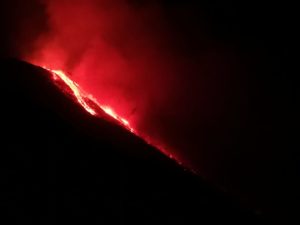
Updated June 21 at 2:55 p.m.
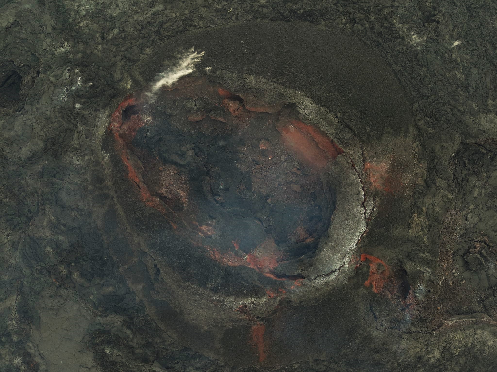
In photos taken this morning during a Civil Defense drone flight, we can see that activity in the crater is decreasing. The crater’s lava flow is not visible on the surface, but can be found in closed channels. However, the lava flows that crossed the dike north of Sýlingarfell yesterday continue to flow. An image from the public safety webcam at Sýlingarfell shows the three lava tubes flowing over the park and the machines working to contain the lava flow. The most active is located in the westernmost lava tongue, which has advanced several meters and thickened in recent hours. The eruptive turbulence is also decreasing and this is clearly visible on the seismometer of the Grindavík Meteorological Agency, as shown in the attached graph.

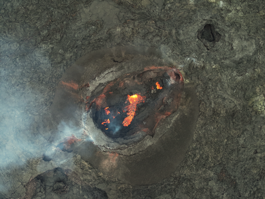
Photo of the crater taken around 9:30 a.m. this morning during a Civil Defense drone flight above the eruptive centers.
The decline in activity in the crater and the decrease in volcanic activity suggest that this eruption may end in the near future, but there is uncertainty about the exact timing. GPS measurements still show land uplift in the Svartsengi region. This indicates that the pressure in the magma accumulation zone below Svartsengi continues to grow, although the speed of uplift is lower than before.
Source : IMO
Photos : Défense civile
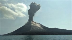
Indonesia , Merapi :
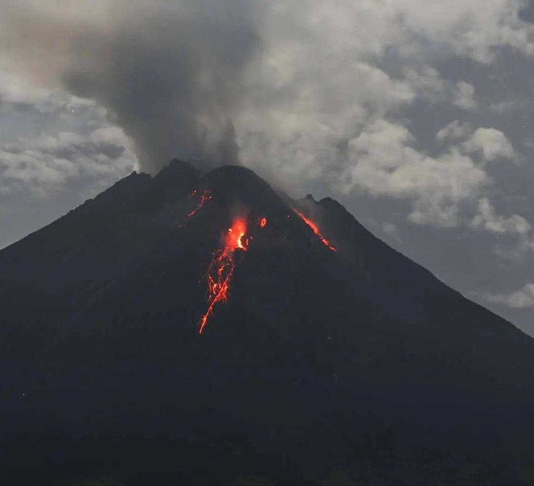
MOUNT MERAPI ACTIVITY REPORT, June 14 to 20, 2024
OBSERVATION RESULT
Visual
The weather around Mount Merapi is generally clear in the morning and night, while it is foggy from noon to evening. White smoke, fine to thick, low to moderate pressure and 100 m high was observed from the observation post of Mount Merapi Babadan on June 17, 2024 at 5:40 p.m. WIB. This week, warm clouds descended twice towards the South-West (upstream of the Bebeng River) for a maximum distance of 1,500 m. Lava avalanches were observed 122 times upstream of the Bebeng River over a maximum distance of 1,700 m. The morphology of the Southwest dome was observed to change due to dome growth activities, hot cloud avalanches, and lava avalanches. The morphology of the median dome is relatively constant. Based on the analysis of aerial photos from a drone survey on June 13, 2024, the volume of the South-West dome was measured at 2,265,000 m3 and that of the Central dome at 2,362,800 m3.
Seismicity
This week, the seismicity of Mount Merapi recorded
2 warm cloud avalanche (APG) earthquakes,
34 superficial volcanic earthquakes (VTB),
128 multi-phase (MP) earthquakes,
2 low frequency (LF) earthquakes,
376 avalanche earthquakes (RF),
11 tectonic earthquakes (TT).
The intensity of earthquakes this week is still quite high.
Deformation
The deformation of Mount Merapi monitored by EDM this week showed a shortening rate of 0.4 cm/day.
Rain and lahars
This week there was rain at Mount Merapi lookout post with a rain intensity of 74 mm/hour for 50 minutes at Kaliurang lookout post on June 15, 2024. No additional flow or lahar was reported in the rivers that have their source on Mount Merapi.
Conclusion
Based on the results of visual and instrumental observations, it was concluded that: The volcanic activity of Mount Merapi is still quite high in the form of effusive eruptive activity. The activity status is set to the “SIAGA” level.
Source : BPPTKG
Photo : Andi Volcanist
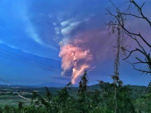
Indonesia , Ibu :
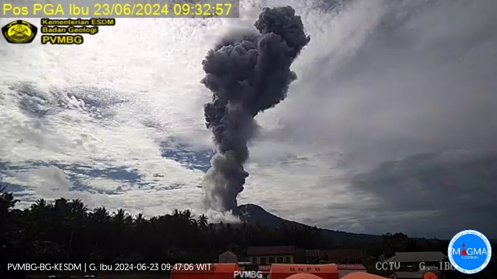
Mount Ibu exhibited an eruption on Sunday 23 June 2024 at 09:27 WIT with the height of the ash column observed at ±5,000 m above the summit (±6,325 m above sea level). The ash column was observed to be gray to black in color with thick intensity, oriented towards the West. This eruption was recorded on a seismograph with a maximum amplitude of 28 mm and a duration of 688 seconds.
VOLCANO OBSERVATORY NOTICE FOR AVIATION – VONA
Issued : June 23 , 2024
Volcano : Ibu (268030)
Current Aviation Colour Code : RED
Previous Aviation Colour Code : orange
Source : Ibu Volcano Observatory
Notice Number : 2024IBU037
Volcano Location : N 01 deg 29 min 17 sec E 127 deg 37 min 48 sec
Area : North Maluku, Indonesia
Summit Elevation : 4240 FT (1325 M)
Volcanic Activity Summary :
Eruption with volcanic ash cloud at 00h27 UTC (09h27 local).
Volcanic Cloud Height :
Best estimate of ash-cloud top is around 20240 FT (6325 M) above sea level or 16000 FT (5000 M) above summit. May be higher than what can be observed clearly. Source of height data: ground observer.
Other Volcanic Cloud Information :
Ash cloud moving to west. Volcanic ash is observed to be gray to dark. The intensity of volcanic ash is observed to be thick.
Remarks :
Eruption recorded on seismogram with maximum amplitude 28 mm and maximum duration 688 second.
Source et photo : Magma Indonésie.
Ecuador , Reventador :
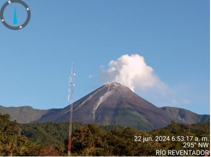
DAILY REPORT ON THE STATE OF THE REVENTADOR VOLCANO, Saturday June 22, 2024.
Information Geophysical Institute – EPN.
Surface activity level: High, Surface trend: No changes
Internal activity level: Moderate, Internal trend: No changes
Seismicity: From June 8, 2024, 11:00 a.m. to June 9, 2024, 11:00 a.m.:
Due to data transmission problems, it was not possible to count volcanic events over the past 24 hours.
Precipitation/Lahars:
No rain was recorded in the volcano area. **In the event of heavy rains, these could remobilize the accumulated materials, generating mud and debris flows which would descend the sides of the volcano and flow into adjacent rivers.
Emissions/ash column:
Due to poor weather conditions, it was not possible to observe gas and/or ash emissions through the surveillance camera system; However, thanks to satellite images, puffs of gas and ash were recorded, with a column height of less than 800 meters above the level of the crater, in a West-Northwest direction. Related to this activity, the VAAC agency in Washington reported two emissions of gas and ash whose columns reached 1,100 meters above the level of the crater and headed towards the West.
Other monitoring parameters:
Over the past 24 hours, the FIRMS satellite system recorded 5 thermal anomalies, while the MIROVA-MODIS and MIROVA-VIIRS systems detected 1 thermal anomaly each.
Observation:
Since yesterday afternoon until the submission of this report, the volcano has remained completely cloudy
Alert Level: Orange
Source : IGEPN.
Photo : Courtoisie M. William Ramírez. 22/06/2024. 06h53 TL.
La Martinique , Montagne Pelée :
Weekly review. Paris Institute of Globe Physics, Martinique Volcanological and Seismological Observatory
Activity on Montagne Pelée, Saint-Pierre, June 21, 2024 at 12:30 p.m. local time (GMT-4)
Volcanic activity remains low this week with 6 earthquakes of volcanic origin observed.
Between June 14, 2024 at 4:00 p.m. (UT) and June 21, 2024 at 4:00 p.m. (UT), the OVSM recorded 6 low-energy volcano-tectonic earthquakes. These earthquakes were clearly identified as originating from one of the well-known seismically active zones at Montagne Pelée, located between 1.0 and 1.4 km depth below the summit of the volcano.
Surface seismicity of the volcano-tectonic type is associated with micro-fracturing in the volcanic edifice linked to the global reactivation of the volcano observed since the end of 2018.
No earthquake was felt by the population.

The previous week, the OVSM had recorded 3 earthquakes of volcanic origin. As of June 21, 2024 and during the last 4 weeks, the OVSM has therefore observed a total of 25 volcanic earthquakes, or an average of 6 to 7 earthquakes per week.
During phases of volcanic reactivation of volcanoes similar to Montagne Pelée, it is usual to observe seismic activity varying in intensity and frequency.
For more details on observations and interpretations of volcanic activity over the longer term, refer to the OVSM monthly bulletins.
The alert level is currently YELLOW: vigilance.
Source : La Direction de l’OVSM-IPGP
Photo : Parc naturel Martinique