July 08 , 2018.
Colombie , Nevado Del Huila :
Subject: Bulletin of extraordinary activity of the Nevado del Huila volcano
The level of activity of the volcano continues at the level:
Level of activity yellow or (III): changes in the behavior of volcanic activity.
Following the activity of VOLCAN NEVADO DEL HUILA, the COLOMBIAN GEOLOGICAL SERVICE informs that:
In addition to the information published by the Colombian Geological Survey, the following aspects are highlighted:
After the Volcano-Tectonic earthquake that occurred yesterday, July 6 at 19:19 local time, magnitude 4.5 and up to the time of sending this bulletin, a total of 401 earthquakes were recorded, of which only the first earthquake (July 6 at 19:19 local time) was reported as being felt by the inhabitants of the Nevado del Huila volcano’s area of influence.
The volcano-tectonic events are located at an average distance of 15 km northeast of the central peak of the Nevado del Huila volcano and the range of depths varies between 7 and 11 km below the summit of the volcano.
Among the seismic swarms mentioned, the most notable events are: Magnitude 4.5 at 19:19 (local time) on July 6, Magnitude 3.4 at 6:43 (local time) on July 7, and two events of Magnitude 3.3 and 3.5 at 11:05 (local time) of July 7th.
It is recalled that the sensors for monitoring magnetic fields and infrasonic waves, have not recorded any variations to highlight.
The COLOMBIAN GEOLOGICAL SERVICE remains attentive to the evolution of the volcanic phenomenon and will continue to inform in a timely manner of the observed changes.
The yellow alert level was declared for the Nevado del Huila volcano, because of the increase in seismic activity that occurred in the last hours in the south of the country.
The Colombian Geological Survey also noted that this Saturday there were two seismic movements of 3.4 and 3.5 degrees on the Richter scale, without affecting the Cauca area, especially in populations such as Toribio at 27. km, Páez (Belalcázar) 31 km, Corinto 38 km from the epicenter.
The authorities made a special appeal to the governors of Cauca, Oscar Rodrigo Campo Hurtado and Huila, Carlos Julio Gonzalez Villa, so that they are very vigilant in watching the neighboring communities of the volcano Nevado del Huila, before a new change of the seismic activity in the region to take all the necessary preventive measures.
Source : Sernageomin , Rcnradio.com
Ecuador / Galapagos , Sierra Negra :
Volcán Sierra Negra Special Report N ° 13 – 2018
Tremor episode on the Sierra Negra volcano
From 5 pm, Galapagos time (Ecuador time +1 am), a tremor seismic signal is recorded on the Sierra Negra volcano. These types of signals are precursors of eruptive activity.
The IGEPN continues monitoring in case of starting an eruptive process.
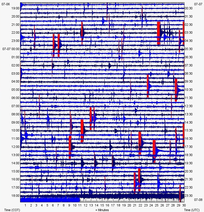
Figure 1: Seismogram of VCH1 station located on the edge of Sierra Negra volcano, showing a tremor signal since 5:00 pm Galapagos time.
The activity of Sierra Negra volcano on Isabela Island, the largest and most western of the Ecuadorian archipelago of Galapagos, continues, announced yesterday, Saturday, July 7, the Institute of Geophysics (IG) of the National Polytechnic School. The IG said on its Twitter account that since the early morning of today, there have been three earthquakes, from M3 to M3.2 on Isabela Island, where the Sierra Negra volcano has started a process eruptive last week. Last Tuesday, the Isabela Island Cantonal Emergency Operations Committee ordered the partial reopening of the Sierra Negra volcano visit site.
https://www.facebook.com/parquenacional.galapagos/videos/1599422163502159/
The Management of the Galapagos National Park explained that among the management measures implemented for visitor entry into the Sierra Negra volcano area while the orange alert is maintained, visitors must have safety equipment ( sunglasses, long pants, long-sleeved shirts, shoes suitable for the field.) Apart from these tools, the guide must have a first aid kit and only in case of evacuation will be allowed entry of motorized vehicles for evacuate visitors to the Caseta El Cura control.
Source : MR, JS. Institut de géophysique , École nationale polytechnique. ElComercio.com ( www.elcomercio.com/actualidad/actividad-volcan-sierra-negra-galapagos.html )
Video : Parque Nacional Galapagos / Sherine France.
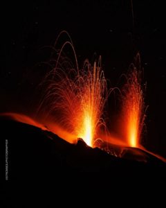
Hawai , Kilauea :
Saturday, July 7, 2018, 8:30 AM HST (Saturday, July 7, 2018, 18:30 UTC)
19°25’16 » N 155°17’13 » W,
Summit Elevation 4091 ft (1247 m)
Current Volcano Alert Level: WARNING
Current Aviation Color Code: ORANGE
Kīlauea Volcano Lower East Rift Zone
The eruption in the lower East Rift Zone (LERZ) continues with no significant change during the past 24 hours.
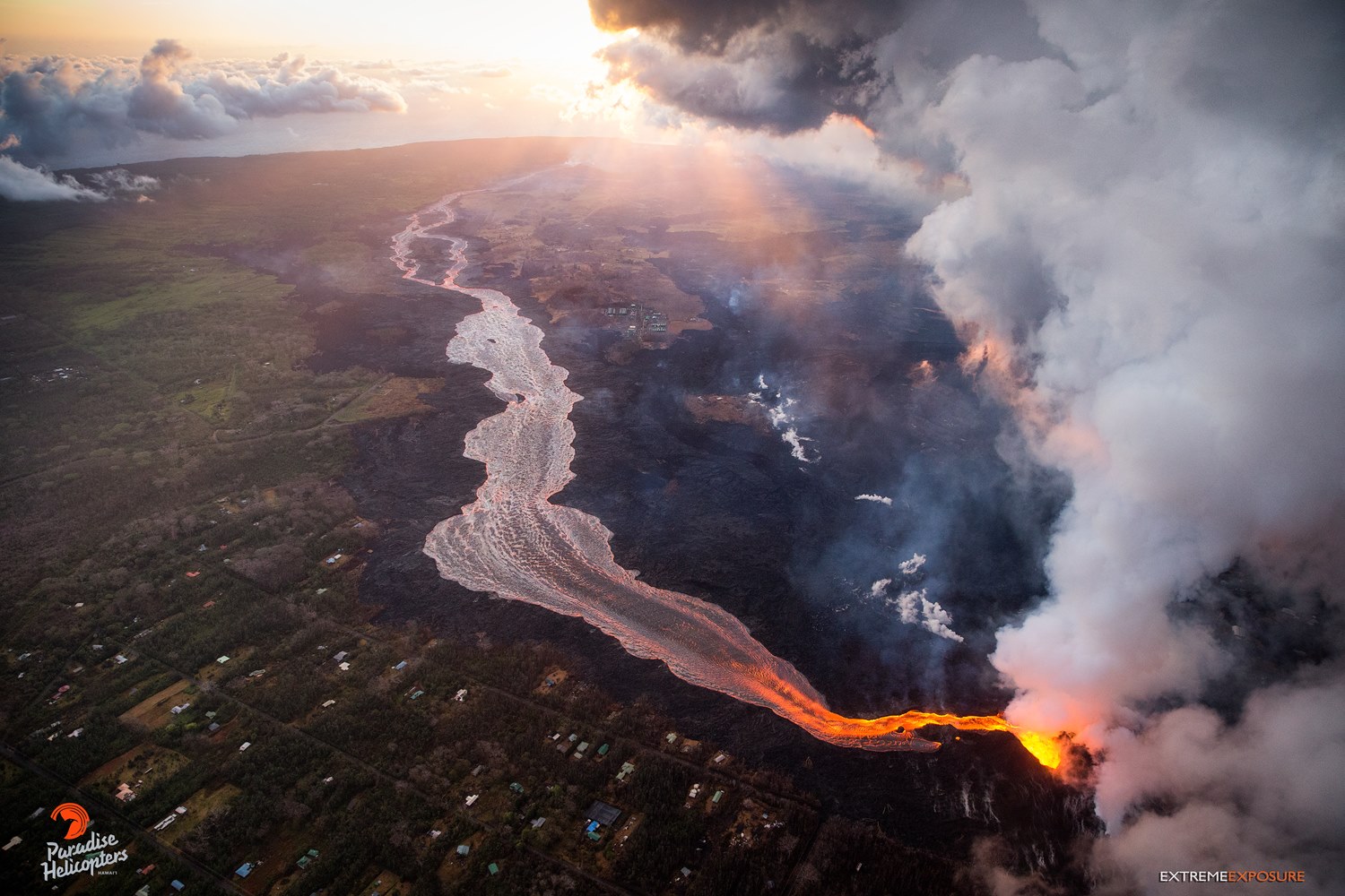
Beautiful sunrise over the immense perched channel, and devastated communities of Leilani Estates and Lanipuna Gardens.
Fountains from Fissure 8 spatter cone continue to supply lava to the open channel with small, short-lived overflows early last night. The spatter cone is now about 55 m (180 ft) tall at its highest point, and fountains rarely rise above that point. As shown by the July 06 thermal map of the flow field, the main lava channel no longer reaches the coast, the channel flow seems to stall about 2 km (1.2 mi) inland of the coast; however, lava is oozing into the ocean from multiple points primarily along the northern section of a broad flow front. In addition, multiple ooze-outs fed flows on the north and the southwest edge of the main `a`a flow but neither had lava actively entering the ocean.
Fissure 22 is still weakly spattering this Morning.
Kīlauea Volcano Summit
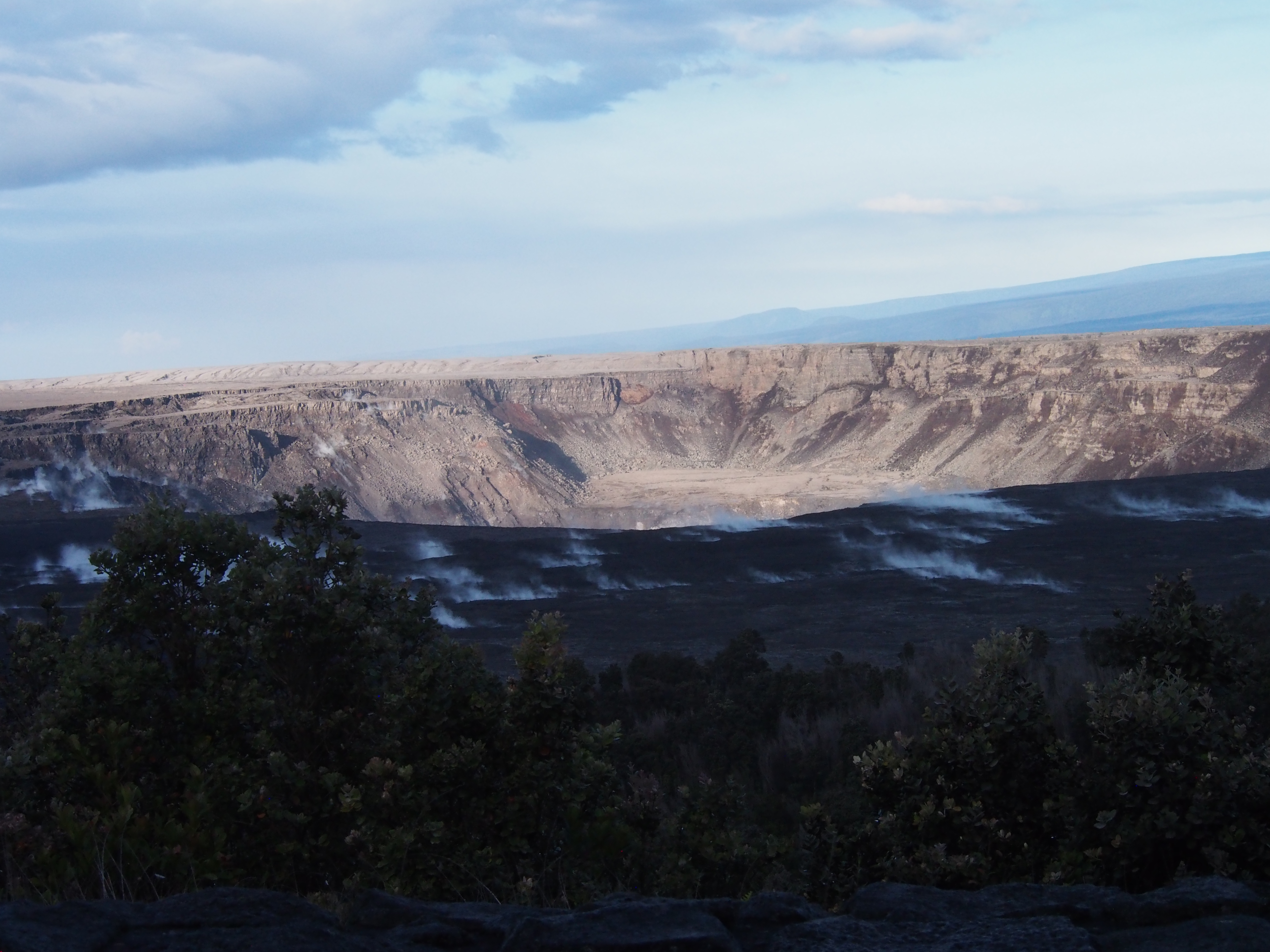
Inward slumping of Halema‘uma‘u continues in response to ongoing subsidence at Kīlauea Volcano’s summit. This image, taken from a temporary observation post located at Volcano House, shows steep walls on the western side of the crater and sloping piles of rubble from rockfall events.
Another collapse explosion event occurred 6:04 PM HST on July 6 at Kīlauea’s summit with the equivalent energy of a magnitude-5.3 earthquake. Seismicity dropped abruptly for several hours afterwards, but has since returned to 25-35 earthquakes per hour, a number of which are in the magnitude 2-3 range. Another collapse explosion is expected later today. Inward slumping of the rim and walls of Halemaʻumaʻu continues in response to ongoing subsidence at the summit.
Source : HVO
Photos : Bruce Omori , USGS.
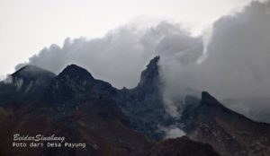
Indonesia : Anak Krakatau :
VOLCANO OBSERVATORY NOTICE FOR AVIATION – VONA.
Issued: July 7 , 2018 .
Volcano:Anak Krakatau (262000)
Current Aviation Colour Code: ORANGE
Previous Aviation Colour Code: orange
Source: Anak Krakatau Volcano Observatory
Notice Number: 2018KRA15
Volcano Location: S 06 deg 06 min 07 sec E 105 deg 25 min 23 sec
Area: Lampung, Indonesia
Summit Elevation: 976 FT (305 M)
Volcanic Activity Summary:
Eruption with volcanic ash cloud at 22h59 UTC (05h59 local). Eruption and ash emission is continuing.
Volcanic Cloud Height:
Ash cloud not visible.
Other Volcanic Cloud Information:
Ash-cloud moving to east-northeast. Anak Krakatau volcano is not clear and not visible.
Remarks:
Eruption recorded on seismogram with maximum amplitude 51 mm and maximum duration 45 second.
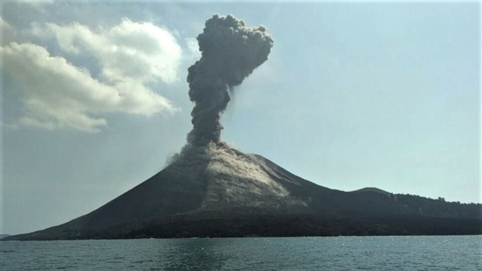
The image of Krakatau shows yesterday that minor explosions have been going on for a few days.
Level II Activity Level (WASPADA). G. Anak Krakatau (305 m above sea level) has increased its activity since 18 June 2018.
Since yesterday until this morning, visually the mountain seems clear without fog. The wind is weak to moderate in the north and west.
The seismographs of July 6, 2018 recorded:
100 earthquakes of eruption
118 earthquake emission.
27 shallow volcanic earthquake
1 deep volcanic earthquake
Recommendation: The company / tourists are not allowed to approach the crater within a radius of 1 km.
Source : Magma Indonesie , PVMBG.
Photo : Iwan / Carita / Andi volcanist
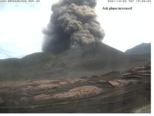
Indonesia , Agung :
At 05:22 WIT or 04:22 WIB today there was a third strombolian eruption after those of January 19, 2018 and July 2, 2018
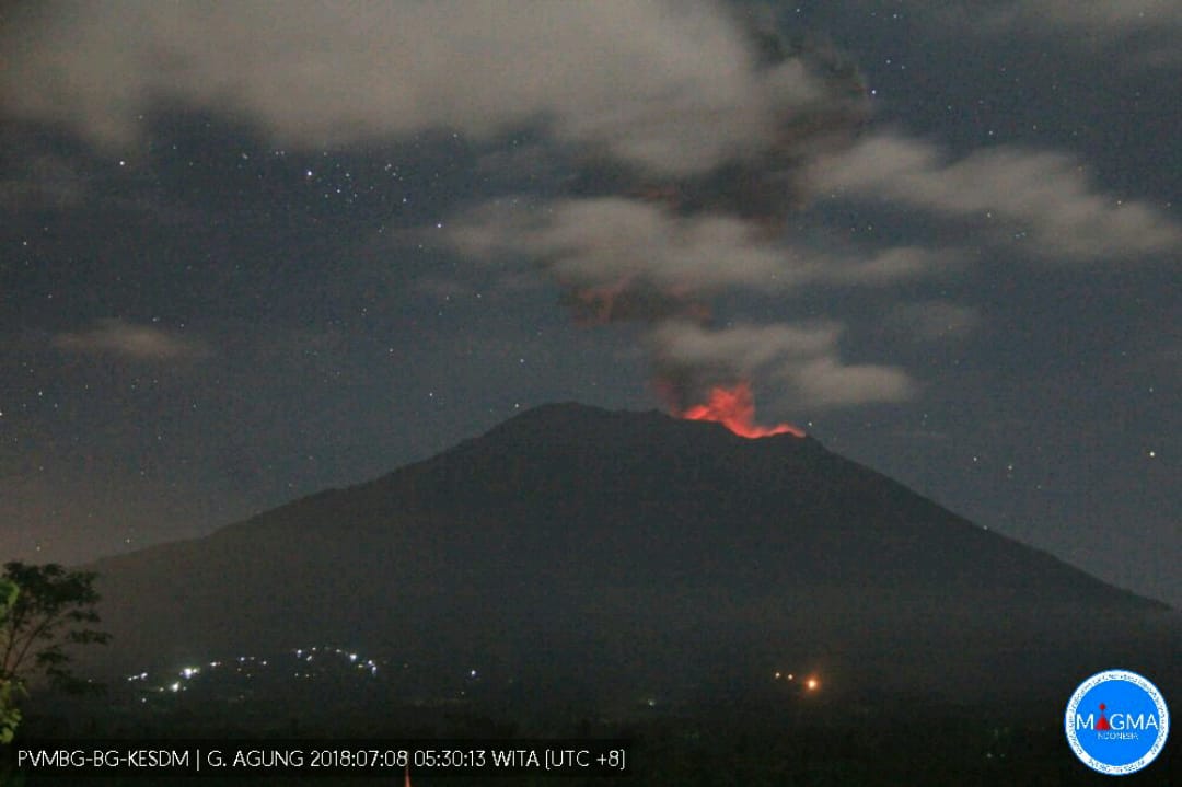
On July 8, 2018, there were 18 eruptions on Mount Agung. The eruption of G. Agung began to occur in November 2017 and lasts to this day. The height of the G. Agung eruption column ranges from 500 to 3000m with an average emission height of 2000m. This shows that the pressure of the interior of the mountain is still relatively constant (SA).
VOLCANO OBSERVATORY NOTICE FOR AVIATION – VONA.
Issued: July 07 , 2018
Volcano: Agung (264020)
Current Aviation Colour Code: ORANGE
Previous Aviation Colour Code: orange
Source: Agung Volcano Observatory
Notice Number: 2018AGU48
Volcano Location: S 08 deg 20 min 31 sec E 115 deg 30 min 29 sec
Area: Bali, Indonesia
Summit Elevation: 10054 FT (3142 M)
Volcanic Activity Summary:
Eruption with volcanic ash cloud at 2122 UTC (0522 local). Eruption and ash emission is not continuing.
Volcanic Cloud Height:
Best estimate of ash-cloud top is around 14854 FT (4642 M) above sea level, may be higher than what can be observed clearly. Source of height data: ground observer.
Other Volcanic Cloud Information:
Ash-cloud is moving west.
Remarks:
Seismic activity is characterized by low frequency earthquakes.
Source : Magma Indonésie , PVMBG.