June 07 , 2024.
Indonesia , Marapi :
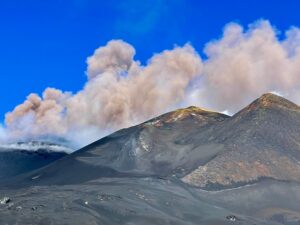
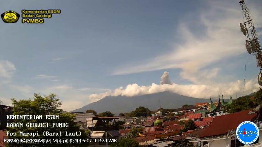
An eruption of Mount Marapi occurred on Friday, June 7, 2024 at 10:57 WIB with the height of the ash column observed at ± 600 m above the summit (± 3491 m above sea level). The ash column was observed to be gray with thick intensity, oriented towards the West. This eruption was recorded on a seismograph with a maximum amplitude of 3 mm and a duration of 72 seconds.
VOLCANO OBSERVATORY NOTICE FOR AVIATION – VONA
Issued : June 07 , 2024
Volcano : Marapi (261140)
Current Aviation Colour Code : RED
Previous Aviation Colour Code : orange
Source : Marapi Volcano Observatory
Notice Number : 2024MAR053
Volcano Location : S 0 deg 22 min 52 sec E 100 deg 28 min 23 sec
Area : West Sumatra, Indonesia
Summit Elevation : 9251 FT (2891 M)
Volcanic Activity Summary :
Eruption with volcanic ash cloud at 03h57 UTC (10h57 local).
Volcanic Cloud Height :
Best estimate of ash-cloud top is around 11171 FT (3491 M) above sea level or 1920 FT (600 M) above summit. May be higher than what can be observed clearly. Source of height data: ground observer.
Other Volcanic Cloud Information :
Ash cloud moving to west. Volcanic ash is observed to be gray. The intensity of volcanic ash is observed to be thick.
Remarks :
Eruption recorded on seismogram with maximum amplitude 3 mm and maximum duration 72 second. Tremor recorded on seismogram with maximum amplitude 1.5 mm.
Source : Magma Indonésie
New Zealand , Ruapehu :
VOLCANIC ACTIVITY BULLETIN , Thu Jun 6 2024 3:00 PM
Volcanic Alert Level remains at 1
Aviation Colour Code remains at Green
The unusual volcanic earthquakes under Mt Ruapehu have considerably reduced in number. The Crater Lake continues to show a slow decline in lake temperature, and water level indicates minor overflows. The volcanic gas monitoring continues to measure low-moderate volcanic gas emissions. The Volcanic Alert Level remains at 1 and the Aviation Colour Code at Green.
Based on the characteristics of these unusual volcanic earthquakes, we have identified them as a type of activity called “spasmodic bursts”. The occurrence of these uncommon style of small volcanic earthquakes beneath Ruapehu has significantly reduced, with just five observed since 10 May.

Each of these bursts usually consist of up to about five minutes of ground shaking. These events remain small, and therefore difficult to locate. Their short duration means that the earthquakes are not categorised as volcanic tremor, which remains low at Ruapehu.
Te Wai ā-moe (Crater Lake) temperature continues to slowly decline. Currently the lake temperature is 16-17 ºC, down from a peak of 31 ºC on 14 February. The lake water level is fluctuating around overflow, likely reflecting less melt water as air temperatures fall and some rain and/or snow input during storms. The cooling of the Crater Lake, together with declining gas flux, is consistent with cooling of the hydrothermal system beneath the lake.
All of the recent observations are consistent with ongoing volcanic and hydrothermal processes and the overall low level of volcanic activity at Mt Ruapehu. A sudden eruption at Mt Ruapehu remains very unlikely. Monitoring indicators remain consistent with a low level of volcanic activity. As a result, the Volcanic Alert Level remains at 1. The Aviation Colour Code remains Green.
Source : Geonet / Paul Jarvis / Duty Volcanologist
Photo : Bradd Scott / GNS Science.
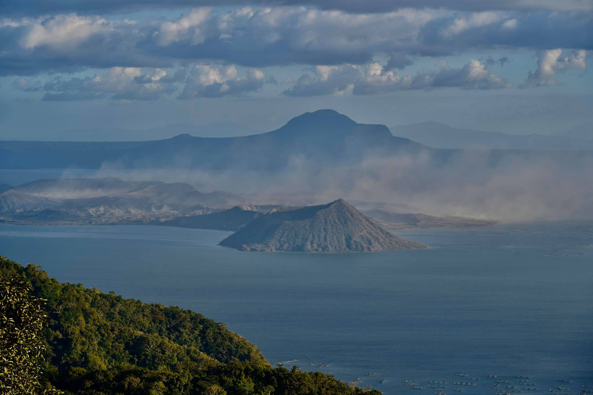
Philippines , Taal :
TAAL VOLCANO ADVISORY , 06 June 2024 , 10:30 PM
Notice of elevated sulfur dioxide degassing from Taal Volcano.
A total of 11,072 tonnes/day of volcanic sulfur dioxide or SO2 gas emission from the Taal Main Crater was measured today, 06 June 2024. Taal has averaged approximately 8,294 tonnes/day for the year and has been continuously degassing voluminous concentrations of SO2 since 2021. Hazy conditions were reported over Alitagtag, Tingloy, San Nicolas, Laurel, Taysan, Lobo and Batangas City and observed during field survey in Agoncillo, Lemery, Taal, Santa Teresita, Alitagtag, Cuenca, Lipa, Balete, and Malvar. PAGASA also forecasts a probable weakening of wind in the coming days which may lead to potential SO2 accumulation and vog formation over Taal region. Prolonged exposure to volcanic SO2 can cause irritation of the eyes, throat and respiratory tract. People who may be particularly sensitive are those with health conditions such as asthma, lung disease and heart disease, the elderly, pregnant women and children. For communities that can be affected by volcanic SO2, please be mindful of the following:
1. Limit your exposure. Avoid outdoor activities, stay indoors and shut doors and windows to block out volcanic gas.
2. Protect yourself. Cover your nose, ideally with an N95 facemask. Drink plenty of water to reduce any throat irritation or constriction. If belonging to the particularly sensitive group of people above, watch over yourself and seek help from a doctor or the barangay health unit if needed, especially if serious effects are experienced.
DOST-PHIVOLCS reminds the public that Alert Level 1 prevails over Taal Volcano, which means that it is still in abnormal condition and should not be interpreted to have ceased unrest nor ceased the threat of eruptive activity. At Alert Level 1, sudden steam-driven or phreatic explosions, volcanic earthquakes, minor ashfall and lethal accumulations or expulsions of volcanic gas can occur and threaten areas within TVI. Furthermore, degassing of high concentrations of volcanic SO2 continues to pose the threat of potential long-term health impacts to communities around Taal Caldera that are frequently exposed to volcanic gas. DOST-PHIVOLCS strongly recommends that entry into TVI, Taal’s Permanent Danger Zone or PDZ, especially the vicinities of the Main Crater and the Daang Kastila fissure, must remain strictly prohibited. Local government units are advised to continuously monitor and assess volcanic SO2 exposure of, and potential impacts on, their communities and undertake appropriate response measures to mitigate these hazards.
DOST-PHIVOLCS is closely monitoring Taal Volcano’s activity and any new significant development will be immediately communicated to all stakeholders.
Source : DOST-PHIVOLCS
Photo : Raffy Tima.
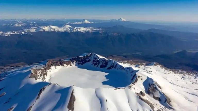
Chile , Puyehue – Cordon Caulle :
Seismology
The seismological activity of the period was characterized by the recording of:
153 seismic events of type VT, associated with the fracturing of rocks (Volcano-Tectonics). The most energetic earthquake had a Local Magnitude (ML) value of 2.5, located 7.5 km South-South-East of the 2011 eruptive center, at a depth of 2.0 km from the crater .
5 LP type seismic events, associated with fluid dynamics inside the volcanic system (Long Period). The size of the largest earthquake evaluated from the Reduced Displacement (RD) parameter was equal to 7 cm2.
1 TO type seismic event, associated with fluid dynamics inside the volcanic system characterized by its particular waveform (TOrnillo). The size of the earthquake (DR) was equal to 4 cm2.
Fluid geochemistry
No anomalies have been reported in emissions of sulfur dioxide (SO2) into the atmosphere in the area near the volcanic complex, according to data published by the Tropopheric Monitoring Instrument (TROPOMI) and the Ozone Monitoring Instrument (OMI) Sulfur Dioxide Group.
Thermal anomalies by satellites
During the period, no thermal alerts were recorded in the area associated with the volcanic complex, according to the analytical processing of Sentinel 2-L2A satellite images in combination of false color bands.
Geodesy
Geodetic observations, based on 4 GNSS stations installed on the volcanic system, indicate that the inflationary process previously reported in the central sector of the Cordón Caulle graben has decreased in magnitude, specifically for this last fortnight, we observe:
– Vertical displacement rate between 0 and 0.54 cm/month.
– Horizontal displacements maintain their trends with slight variations in magnitude, with maximum displacement rate amplitudes of 1 cm/month.
– Increasing the distance between stations also decreases its rate to magnitudes less than 0.8 cm/month.
– As observed by permanent and field (temporary) GNSS stations, since the beginning of monitoring in the volcanic complex, pauses have been observed in the inflationary process, which can be maintained for a few months, then inflation continues.
It should be noted that the area around the point of emission of the 2011 eruption exhibits active subsidence, a consequence of the cooling of the shallow magma body remaining from this eruption.
Surveillance cameras
The images provided by cameras installed near the volcanic complex did not record degassing columns or variations linked to surface activity.
Satellite geomorphological analysis
Thanks to the processing of PlanetScope and Landsat 8-9 satellite images, no geomorphological change is detected.
Seismicity remains within the margins recorded since mid-2020. No REAV was issued during the period evaluated. The deformation shows an obvious decrease in vertical and horizontal movements, which could represent a pause in the inflationary process, as has been evident in previous years, at the same periods. In turn, geological data indicate that no morphological changes attributable to increased volcanic activity have been identified.
In accordance with this context, the technical volcanic alert is maintained in:
YELLOW TECHNICAL ALERT: Changes in the behavior of volcanic activity
Source : Sernageomin
Photo : Bariloche2000
Hawaii , Kilauea :
HAWAIIAN VOLCANO OBSERVATORY DAILY UPDATE
Thursday, June 6, 2024, 10:34 AM HST (Thursday, June 6, 2024, 20:34 UTC)
19°25’16 » N 155°17’13 » W,
Summit Elevation 4091 ft (1247 m)
Current Volcano Alert Level: ADVISORY
Current Aviation Color Code: YELLOW
Activity Summary:
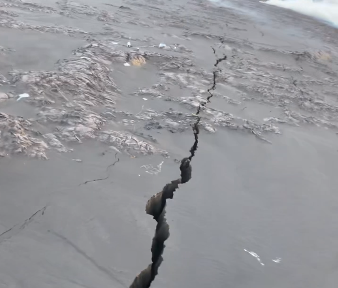
Kīlauea volcano is not erupting. The eruption that began on Monday, June 3, southwest of Kaluapele (Kīlauea caldera) within Hawai’i Volcanoes National Park remains paused. Tremor, degassing, and incandescence associated with the fissure vents are still present but have decreased significantly since June 3, making it unlikely that this eruption will restart. Volcanic gas emissions at the eruption site remain above background levels. Overall seismicity in the summit region including the eruption area remains low. Inflationary ground deformation of the summit continues. Although the eruption has paused, additional pulses of seismicity and deformation could result in new eruptive episodes within the area or elsewhere on the Southwest Rift Zone.
Eruption Site Observations:
Lava stopped erupting from the fissure vents at approximately 9:00 a.m. HST on June 3 and lava flows stagnated by noon that day. Lava from the fissure system covered approximately 90 acres (350,000 square meters), a relatively small area. Glow continued to be observed in webcam imagery last night at the site of the fissures, although glow intensity was lower than previous nights.
Volcanic gas emissions at the eruption site remain above background levels (100 tonnes per day or less). Sulfur dioxide (SO2) emission rates of 12,000-15,000 t/d were measured on June 3, and 5,500 t/d on June 4. Emission rates are much lower today compared to previous days; precise measurements are being made by HVO field crews at the time of this report.
Numerous large ground cracks have formed in the vicinity of the eruption extending westward to within 540 yards (500 meters) of Maunaiki. Earthquake activity remains low in the eruption site area.
Summit and Upper Rift Zone Observations:
Rates of seismicity beneath the summit, upper East Rift Zone, and upper Southwest Rift Zone remained low over the past day. Tremor continues to decrease across the summit region and is approaching background levels. Less than 50 earthquakes occurred over the past 24 hours. Earthquakes were mostly located beneath the south caldera region, at depths of 1.5-3 km (1–1.8 miles), with magnitudes under M2.5. Inflationary ground deformation of the summit continued over the past day. The Uēkahuna tiltmeter northwest of the summit recorded overall inflation of approximately 2.5 microradians over the past 24 hours; the rate of inflation decreased at about 6:00 p.m. last night, then increased again at about 1:00 a.m. this morning. The Sand Hill tiltmeter southwest of the summit recorded approximately 9 microradians of inflation over the past 24 hours.
Analysis:
The last eruption in this area occurred in December 1974. The 1974 eruption lasted 6 hours and erupted 13 million cubic yards (10 million cubic meters) of lava that covered about 3 square miles (7 square kilometers). In contrast, the June 3, 2024, eruption lasted 8.5 hours but only erupted about 1% of the volume and covered about one third of a square mile (one half of a square kilometer). The pasty surface textures of the erupted lava and the small amount of lava erupted suggests that this lava could have been first emplaced during the January 31, 2024, intrusive event and cooled prior to being forced to the surface by the new dike
Source : HVO
Photo : Capture d’écran HVO