Following a site crash, the last posts since the holidays are lost. Sorry.
June 06 , 2024.
Italy , Stromboli :
WEEKLY BULLETIN, from May 27, 2024 to June 2, 2024. (issue date June 4, 2024)
SUMMARY STATEMENT OF ACTIVITY
In light of the monitoring data, it appears:
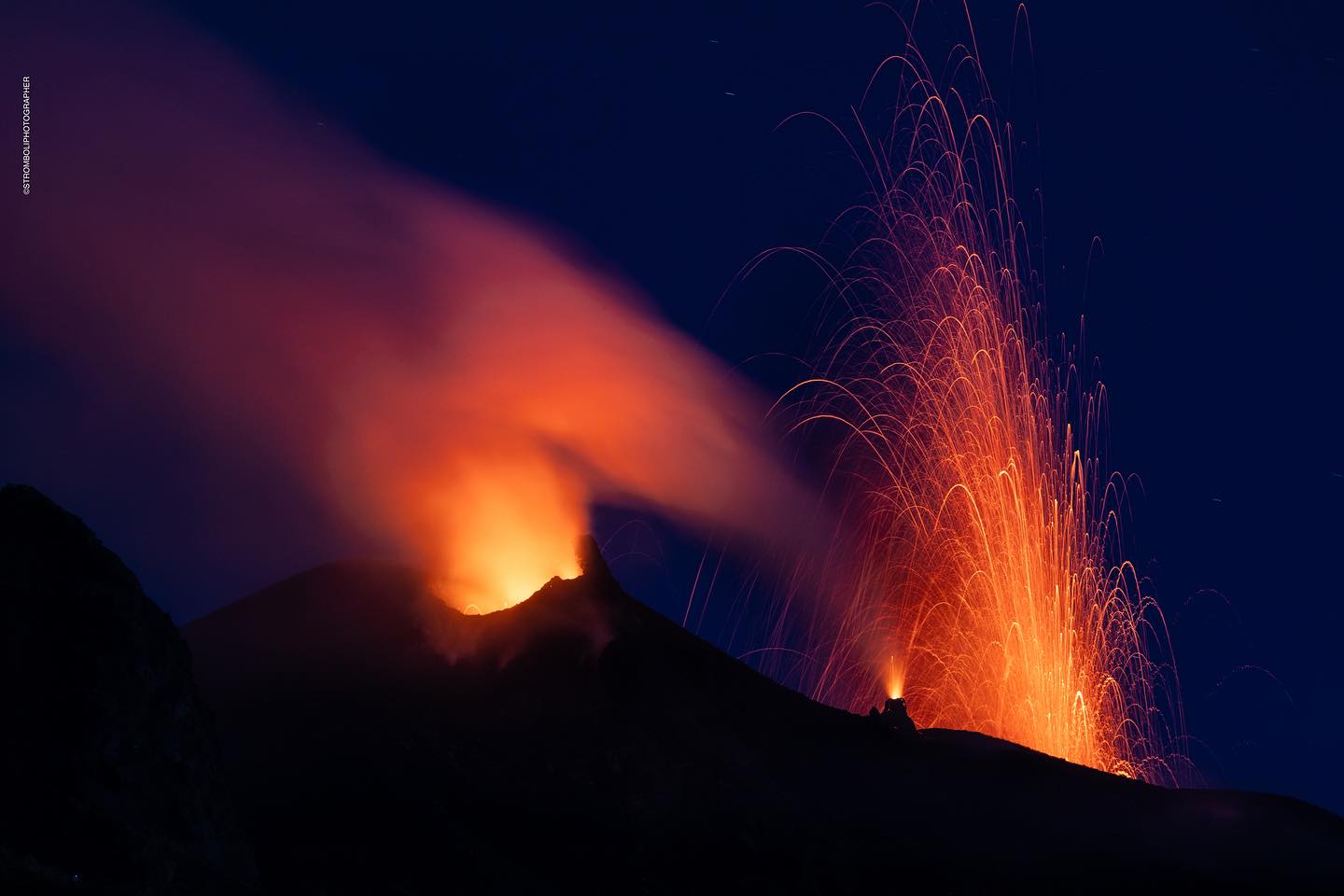
1) VOLCANOLOGICAL OBSERVATIONS: During this period, normal Strombolian activity was observed with splashing activity and lava overflow. The total hourly frequency of explosions fluctuated between medium values (13 events/h) and high values (20 events/h). The intensity of the explosions was mainly low and medium, both in the North Crater area and in the South Central Crater area.
2) SISMOLOGY: The monitored seismological parameters do not show significant variations.
3) GROUND DEFORMATIONS: Continuous signals from ground deformation monitoring networks did not show significant variations
4) GEOCHEMISTRY: The flow of SO2 at an average level
The CO2 flux in the summit zone is at average values.
The C/S ratio in the plume shows high values.
The isotopic ratio of Helium dissolved in thermal wells shows high values.
CO2 flow in Mofeta in the San Bartolo area: increasing, on average.
CO2 flux in Scari: stable values at average levels.
VOLCANOLOGICAL OBSERVATIONS
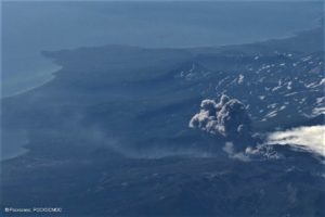
During the observed period, the eruptive activity of Stromboli was characterized through the analysis of images recorded by the INGV-OE surveillance cameras located at Pizzo (SPT), at altitude 190 m (SCT-SCV) and at Point dei Corvi (SPCT). . The explosive activity was mainly produced by 2 (two) eruptive vents located in the North area of the crater and by 2 (two) vents located in the South Central area. A lava overflow was observed on May 27 from the northern zone.
Observations of explosive activity captured by surveillance cameras
In the area of the North crater (N), with a vent located in sector N1 and one in sector N2, explosive activity was observed mainly of low intensity (less than 80 m in height) and medium intensity (less 150 m high). Furthermore, almost continuous and sometimes intense projection activity was observed in sector N1. The products emitted in the eruption were mainly coarse materials (bombs and lapilli). The average frequency of explosions fluctuated between 11 and 15 events/h.
In the Central-South zone (CS), sectors C and S1 showed no activity while in sector S2, with two emission points, the explosions were of varying intensity from low (less than 80 m from height) to medium (less than 150 m height) emitting fine materials. The average frequency of explosions varied from 1 to 6 events/h.
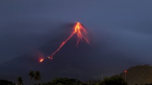
Lava overflow of May 27, 2027
On May 27, from 10:35 UTC, intense projection activity at the vent located on the hornito in sector N1 produced a modest lava flow which stopped after a few dozen meters. in the upper part of the Sciara del Fuoco. At 17:00 UTC, the lava flow appeared unfed and cooling.
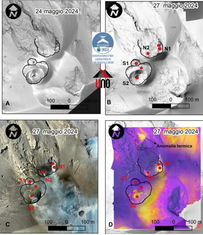
Fig. 3.4 A) and B) Shaded terrain models of May 24 and 27, C) and D) visible and thermal orthomosaics of May 27. Active vents are red, crater rims are black.
Morpho-structural characterization of the crater terrace using drones
As part of the activities of the DPC-INGV execution agreement and the UN project, drone surveys were carried out on May 27. Image processing made it possible to create the digital terrain model, the orthomosaic and the thermal orthomosaic of the summit area of Stromboli up to an altitude of 590 m above sea level (fig. 3.4 A, B ,C,D).
The thermal orthomosaic highlights the presence of 6 active vents, the thermal anomaly remains at an altitude of 650 m above sea level (Fig. 3.4 D), already reported in the Rep bulletin. N. 14/2024 STROMBOLI.
From the difference in DTM between May 27 and 24, 2024, we can see the accumulation of volcanic material produced by projection activity near active vents. The lack of material due to the partial collapse of hornito N1 on May 26 is also evident (Fig. 3.5 A, B and C).
Source : INGV
Photos : Stromboli stati d’animo / Sebastiano Cannavo , INGV.
Hawaii , Kilauea :
Wednesday, June 5, 2024, 12:03 PM HST (Wednesday, June 5, 2024, 22:03 UTC)
19°25’16 » N 155°17’13 » W,
Summit Elevation 4091 ft (1247 m)
Current Volcano Alert Level: ADVISORY
Current Aviation Color Code: YELLOW
Activity Summary:
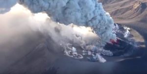
Kīlauea volcano is not erupting. The eruption that began at approximately 12:30 a.m. HST on Monday, June 3, about 4 km (2.5 miles) southwest of Kaluapele (Kīlauea caldera) within Hawai’i Volcanoes National Park has been paused for 48 hours and is unlikely to restart. Tremor, degassing, and incandescence associated with the fissure vents have decreased substantially over the past 48 hours, making it unlikely that the eruption will resume. While decreasing, volcanic gas emissions at the eruption site remain well above background levels. Overall seismicity in the summit region including the eruption area remains low. Rates of inflationary ground deformation in the summit region increased over the past day. The USGS Hawaiian Volcano Observatory (HVO) lowered the Volcano Alert Level for ground-based hazards from WATCH to ADVISORY and the Aviation Color Code from ORANGE to YELLOW at 10:07 a.m HST this morning.
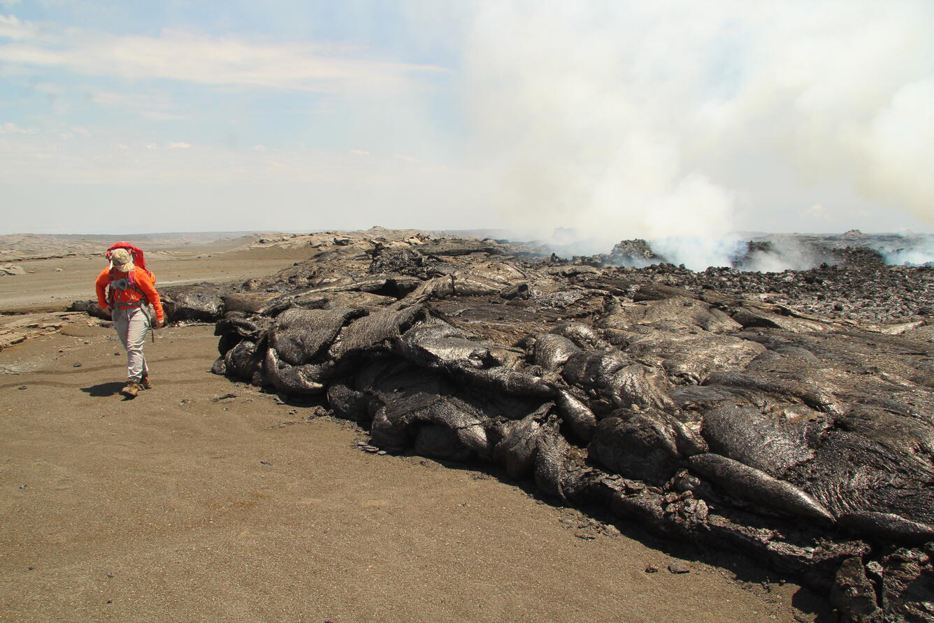
Note that none of the lava flow is as tall as the geologist; similar to the December 1974 eruption from the same area on Kīlauea, the eruption of June 3 produced extremely thin Pāhoehoe flows. This contrasts with other recent eruptions like that at Pu‘u‘ō‘ō on Kīlauea’s East Rift Zone between 1983 and 2018, where Pāhoehoe flows sometimes inflated to tens of meters in thickness.
Eruption Site Observations:
Lava stopped erupting from the fissure vents at approximately 9:00 a.m. HST on June 3 and lava flows stagnated by noon that day. Lava from the fissure system covered approximately 90 acres (350,000 square meters), a relatively small area. Glow was observed in webcam imagery overnight at the site of the fissures. Volcanic gas emissions at the eruption site remain well above background levels (100 tonnes per day or less), with a sulfur dioxide emission rate of 5,500 tonnes per day (t/d) measured yesterday, June 4, down from 12,000-15,000 t/d on June 3. The lack of trade wind conditions this morning may increase the potential for higher vog concentrations around the summit of Kīlauea.
Numerous large ground cracks have formed in the vicinity of the eruption extending westward to within 540 yards (500 meters) of Maunaiki. Earthquake activity remains low in the eruption site area.
Summit and Upper Rift Zone Observations:
Rates of seismicity beneath the summit, upper East Rift Zone, and upper Southwest Rift Zone remained low over the past day. Tremor related to the eruptive vents continues to decrease across the summit region. Less than 30 earthquakes have occurred over the past 24 hours. Earthquakes were located beneath the south caldera and the upper East Rift Zone, at depths of 1.5-3 km (1–1.8 miles), with magnitudes under M2.0. Ground deformation beneath Halemaʻumaʻu and the south caldera region transitioned to inflation over the past 24 hours. The Uēkahuna tiltmeter northwest of the summit recorded a deflationary signal yesterday morning that transitioned to inflation around noon yesterday, with approximately 3 microradians of inflation since then. The Sand Hill tiltmeter southwest of the summit recorded approximately 6 microradians of inflation since 4:00 p.m. yesterday.
Lower Rift Zone Observations:
Rates of seismicity and ground deformation beneath the middle and lower East Rift Zone and lower Southwest Rift Zone are low. Eruptive activity and unrest is restricted to the summit and upper rift zone regions. Measurements from continuous gas monitoring stations downwind of Puʻuʻōʻō in the middle East Rift Zone remain below detection limits for SO2, indicating that SO2 emissions from Puʻuʻōʻō are negligible.
Source : HVO
Photo : USGS / M. Zoeller (HVO).
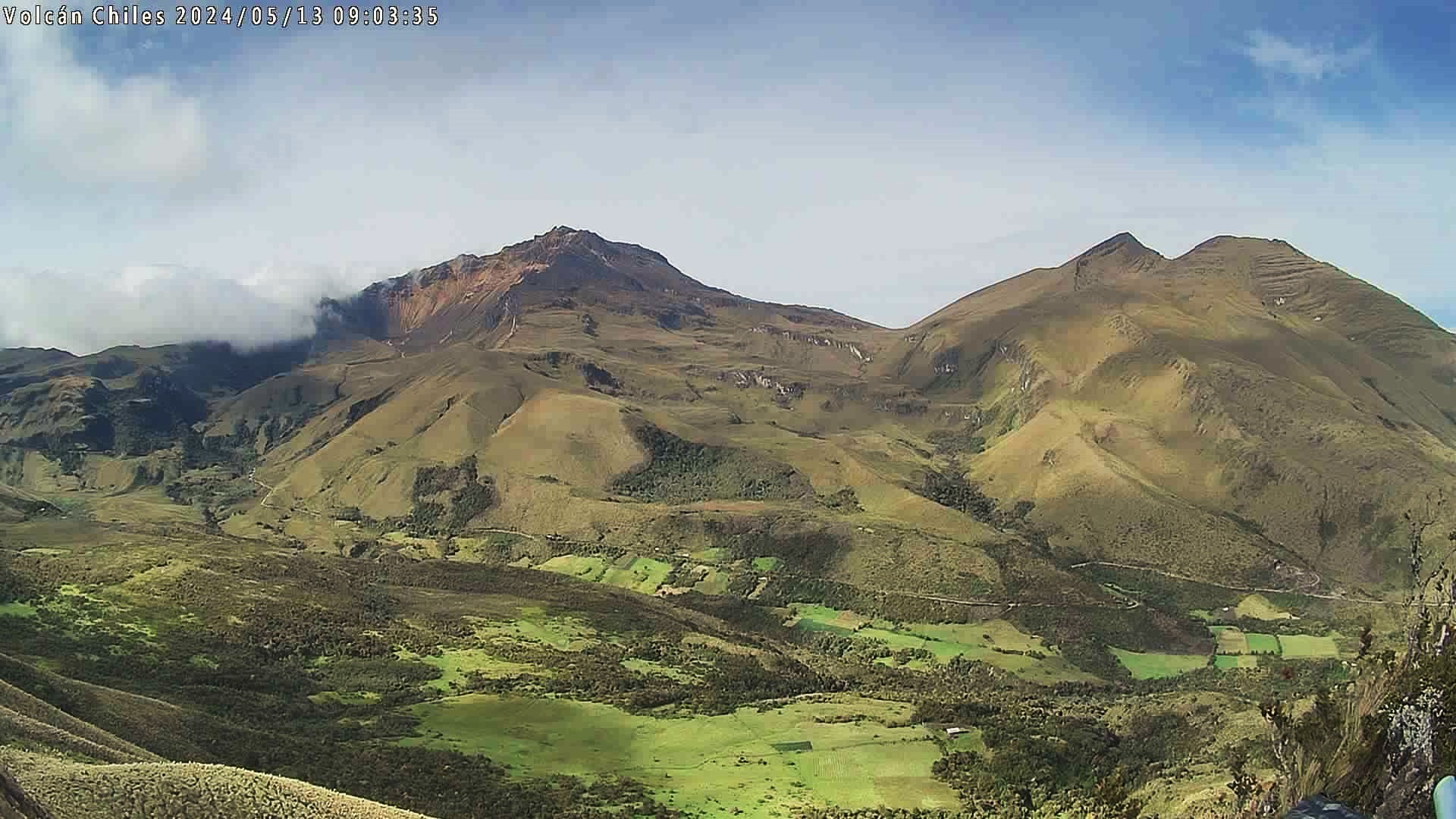
Colombia , Chiles / Cerro Negro :
Weekly activity bulletin: Chiles Volcanic Complex and Cerro Negro (CVCCN).
Regarding the monitoring of the activity of the CHILES AND CERRO NEGRO VOLCANOES, the COLOMBIAN GEOLOGICAL SERVICE (SGC), an entity attached to the MINISTRY OF MINES AND ENERGY, reports that:
Similar to what was recorded in previous weeks, a fluctuation in the levels of occurrence and seismic energy was observed for the week evaluated between May 28 and June 3, 2024, with a decrease in occurrence and an increase in the energy released. The predominance of seismicity associated with rock fracture has continued, but the recording of a few earthquakes associated with fluid movement continues, some of them at very low frequency.
The fracture earthquakes were located scatteredly in the region of the two volcanoes, at distances of up to 12 km, with depths between 2 and 11 km from the summit of Chiles (4,700 m above sea level). altitude) and a maximum local magnitude of 2.1. of earthquake felt.
Volcanic deformation processes recorded by sensors installed on the ground and by remote satellite sensors continue. The evolution of activity in the CVCCN is the result of internal processes derived from the complex interaction between the magmatic system, the hydrothermal system and the geological faults of the area. Therefore, the probability of the occurrence of energetic earthquakes that can be felt by residents in the region of influence of the CVCCN persists.
Volcanic activity remains in a YELLOW ALERT state: active volcano with changes in the behavior of the base level of monitored parameters and other manifestations.
Source et photo : SGC
Philippines , Kanlaon :
KANLAON VOLCANO LAHAR ADVISORY , 06 June 2024 , 12:00 AM
Based on the Philippine Atmospheric Geophysical and Astronomical Services Administration (PAGASA) Thunderstorm Advisory #7 and #9, localized thunderstorms were expected to bring moderate to heavy rains over Kanlaon Volcano and Negros Island. Thunderstorms in the early afternoon today generated volcanic sediment flows or lahars on the southern slopes that were detected by three seismic stations of the Kanlaon Volcano Network (KVN). These lahars began approximately around 1:00 PM and lasted 25 minutes based on the seismic record. A total of 23.75 mm of rain over a two-hour period was also recorded by the All-Weather Station of the Manghumay, Mailum, Bago City Observation Station (VKMH) of the KVN. Higher rainfall volumes may have likely occurred around the summit area of the volcano.
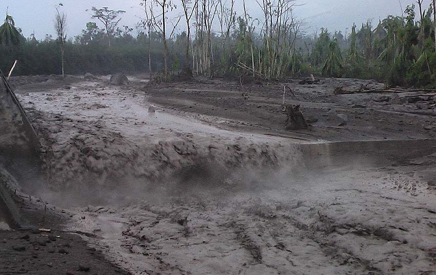
Lahars have been reported by netizens in various social media posts and verified by PHIVOLCS’ Quick Response Team (QRT) on the field. Grey cohesive mud, plant debris and gravel have been deposited by lahars in at least four (4) waterways: Tamburong Creek, which courses through Biak-na-bato and Calapnagan, La Castellana; Intiguiwan River in Guinpanaan and upstream Baji-Baji Falls in Cabacungan, La Castellana; Padudusan Falls, Masulog, Canlaon City; and the Binalbagan River, which drains the southern flank of Kanlaon Volcano. The lahars were generally channel-confined, but flows along Tamburong Creek overflowed and dumped a few centimeters of deposit on a stretch of the main road in Biak-na-Bato, rendering this impassable to motorists.
PAGASA forecasts thunderstorms on 6 June 2024 that can bring heavy rains over Negros Island. These rains could generate lahars, muddy streamflows or muddy run-off in the above-mentioned and other rivers draining the southern Kanlaon edifice. Lahars can threaten communities along the middle and lower slopes with inundation, burial and wash out. PHIVOLCS thus strongly recommends increased vigilance and readiness of communities along rivers draining southern Kanlaon. These communities and local government units are advised to continually monitor weather conditions and take pre-emptive response measures for their safety from potential lahars.
Source : Phivolcs
Photo : Caroline Sarrazin , Rés-EAUx .
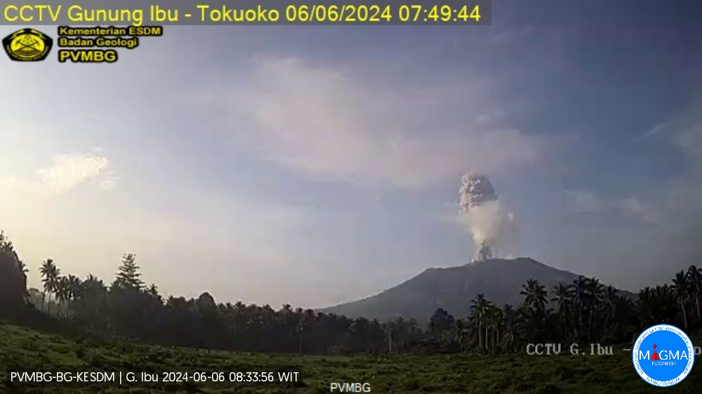
Indonesia , Ibu :
An eruption of Mount Ibu occurred on Thursday, June 6, 2024 at 07:46 WIT with the height of the ash column observed at ±1,200 m above the summit (±2,525 m above sea level) . The ash column was gray in color with moderate to thick intensity, oriented to the West and Northwest. This eruption was recorded on a seismograph with a maximum amplitude of 4 mm and a duration of 160 seconds.
SEISMICITY OBSERVATIONS:
2 eruption earthquakes with an amplitude of 4 mm and a seismic duration of 130 to 160 seconds.
16 emission earthquakes with an amplitude of 2 to 12.5 mm and earthquake duration of 20 to 67 seconds.
62 Shallow volcanic earthquakes with an amplitude of 2 to 8 mm and an earthquake duration of 6 to 20 seconds.
3 local tectonic earthquakes with an amplitude of 3.5 to 6.5 mm, and an earthquake duration of 26 to 120 seconds.
2 distant tectonic earthquakes with an amplitude of 4-12.5 mm and earthquake duration 64-212 seconds.
RECOMMENDATION
1. Communities around Mount Ibu and visitors/tourists should not carry out activities within a radius of 4 km and a sectoral extension of 7 km towards the crater opening in the northern part of the active Mount Ibu crater.
2. In the event of ash falling, people who carry out activities outside the house are advised to protect their nose, mouth (mask) and eyes (glasses).
Source et photo : Magma Indonésie .