March 02 , 2019.
La Réunion , Piton de la Fournaise :
Activity Bulletin from Friday, March 1, 2019 to 17:00 (local time).
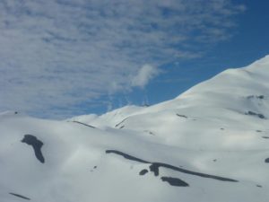
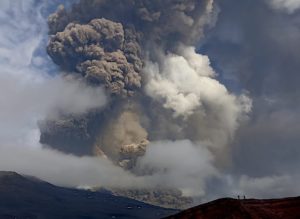
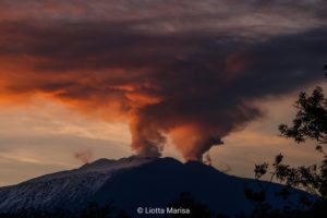
The eruptive activity that resumed on February 19, 2019 at Piton de la Fournaise around 7:10 pm local time continues. Despite slight fluctuations in intensity since February 25, the eruptive tremor remained relatively constant for several days (Figure 1).
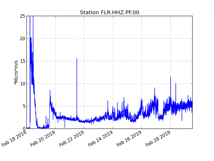
Figure 1: Evolution of the RSAM (indicator of the volcanic tremor and the intensity of the eruption) between 09h48 (05h48 UTC) on February 18th and 16h30 (12h30 UTC) on March 1st on the seismic station of FLR. (© OVPF / IPGP)
– Over the last 36 hours, only one top-level superficial volcano-tectonic earthquake (above sea level) has been recorded.
– After a deflation of the building related to the transfer of magma that occurred on 18/02/2019, the deformations of the summit zone do not show any particular signals.
– The CO2 concentrations in the near-field soil (cottage volcano area) remain high.
– Over the last 36 hours, surface flows estimated from satellite data, via the HOTVOLC platform (OPGC – University of Auvergne), fluctuated between <1 and 12 m3 / s. Note that low values (or zero values) are recorded when cloud cover does not allow acquisition.
Alert level: Alert 2-2.
Source : OVPF.
Russia / Kuriles Islands , Ebeko :
VOLCANO OBSERVATORY NOTICE FOR AVIATION (VONA).
Issued: March 01 2019
Volcano:Ebeko (CAVW #290380)
Current aviation colour code:ORANGE
Previous aviation colour code:orange
Source:KVERT
Notice Number:2019-46
Volcano Location:N 50 deg 41 min E 156 deg 0 min
Area:Northern Kuriles, Russia
Summit Elevation: 3791.68 ft (1156 m)
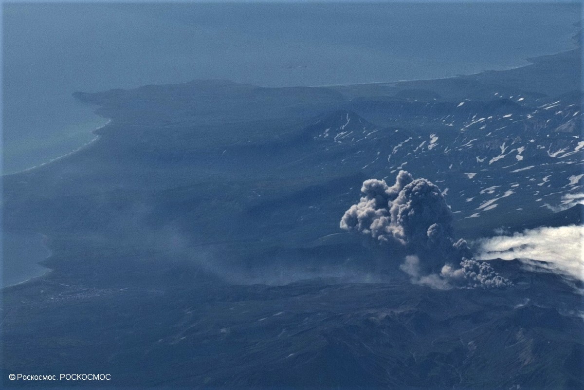
Explosive eruption of Ebeko volcano at 23:22 GMT on August 21, 2018.
Volcanic Activity Summary:
A moderate explosive activity of the volcano continues. Visual data from Severo-Kurilsk showed an explosion sent ash up to 2.0 km a.s.l., an ash plume is drifting to the south from the volcano.
A moderate eruptive activity of the volcano continues. Ash explosions up to 19,700 ft (6 km) a.s.l. could occur at any time. Ongoing activity could affect low-flying aircraft and airport of Severo-Kurilsk.
Volcanic cloud height:
6560 ft (2000 m) AMSL Time and method of ash plume/cloud height determination: 20190301/0710Z – Visual data
Other volcanic cloud information:
Distance of ash plume/cloud of the volcano: 3 mi (5 km)
Direction of drift of ash plume/cloud of the volcano: S
Time and method of ash plume/cloud determination: 20190301/0710Z – Visual data
Source : Kvert
Photo : Roskosmos , 21/8/2018
Vanuatu Archipelago , Ambrym :
Media Release issued by the Vanuatu Meteorology and Geohazards Department on 28th February 2019 on the « Eruption of Ambrym Volcano, December 2018.
A moderate scale but short-lived summit caldera eruption occurred at Ambrym volcano in mid-December 2018. Observations and data analysis by scientists from the Geohazards division of the Vanuatu Meteorology and Geo-Hazard Department (VMGD) suggests this eruption is now over. However aspects of the longer term volcanic hazard may have changed due to this eruption.
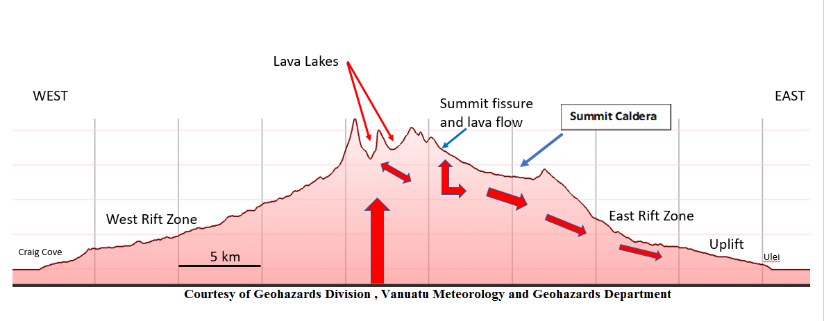
Figure 1:
Cartoon showing a cross section of Ambrym volcano (west to east). Molten material from depth feeds the lava lakes, the summit rift eruption and lava flow. Some also moves down into the Eastern Rift Zone, causing the strong earthquake activity and uplift.
Observations and data show that the December 2018 eruption had affected three areas on the volcano (summit craters of Benbow and Marum, the summit caldera and the Eastern Rift Zone down to the coast). The eruption commenced very quickly on 15 December and the Vanuatu Volcanic Alert Level (VVAL) was changed from level 2 to Level 3 by VMGD. The volcanic activities included the draining of the lava lakes, explosive ash eruptions from Benbow and Marum craters, a short lived but very spectacular lava fountain eruption on the caldera floor and lava flows. Magma drained from under the summit area into the Eastern Rift Zone, resulting in large ground cracks, earthquakes and uplift of the coastal area (see diagram 1). Ash fall from the explosive ash eruptions at Benbow and Marum craters had affected villages on the northern side of the island.
Some aspects of the December 2018 eruption were like the eruption in 2015, especially the spectacular lava fountain on the caldera floor and lava flows, along with the draining of the lava lakes in Benbow and Marum craters.
The Vanuatu Volcanic Alert Level (VVAL) of Ambrym volcano had been at the Level 2 (major volcanic unrest) since 7 December 2017 and remained so throughout 2018. The major volcanic unrest during 2018 included elevated SO2 (Sulphur dioxide) gas output in July and October, an increase in volcanic tremor in late September to early October and an elevated lava lakes level in early December. It was not clear at the time that an eruption would develop from this unrest.
On 15 December in response to a large increase in earthquake activity, as the summit eruption started, VMGD raised the Vanuatu Volcanic Alert Level for the volcano to Level 3 (minor eruption). The volcano then entered an explosive phase, lava fountaining along a fissure and lava flows on to the caldera floor. Explosive ash eruptions had started from Benbow and Marum craters as their lava lakes level dropped. This phase of the eruption only lasted 2-3 days.
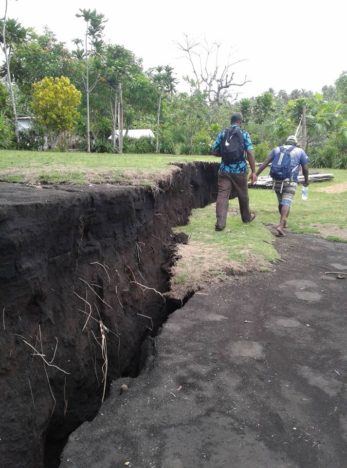
The lava from the summit area moved underground into the Eastern Rift Zone generating strong earthquake activity. This affected the area from the summit caldera down to the coast, resulting in large ground cracks, earthquakes and uplift of the coastal area. A disturbance was also noted off shore with the small seashore activity at the edge of one of the major faults ejected small light volcanic stones (pumice) based on the assessment conducted in February 2019. The strongest earthquake activity was on 16th December (38 greater than M4).
The activity at Ambrym has declined and the possibility of a large eruption affecting the whole island is now looking less likely. This has been confirmed from the observations and field assessment conducted on 3rd to 9th February 2019. Therefore its Volcanic Alert Level (VVAL) was lowered from Level 3 (minor eruption) to Level 2 (major unrest state) on 14th February 2019.The intrusion of molten rock (magma) into the Eastern Rift Zone from the summit zone, has now preloaded this volcanic feature and the potential volcanic hazards have changed. Should a further intrusion occur into the Eastern Rift, it may be easier for the magma to reach the surface, like in the 1913 eruption on the Western Rift.
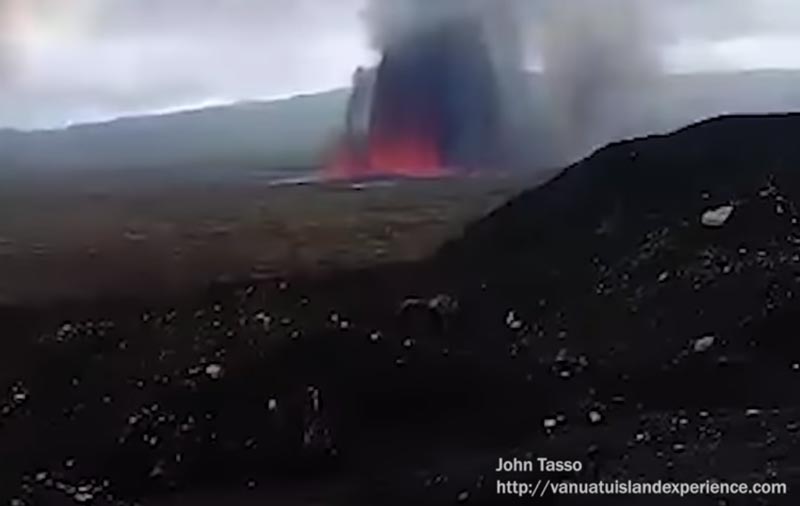
Figure 2:
Satellite image showing intra fissure eruption and lava flow on 15th December 2018 at the SE of the caldera.
Scientists from VMGD will keep monitoring closely the activity, remotely from Port Vila, thanks to a network of instruments on Ambrym, and nearby islands. VMGD staff also have access to satellite data that records the gas output and thermal data. The VMGD staff are able to view data from seismic station on Ambrym and a web camera (http://www.vmgd.gov.vu/vmgd/index.php/geohazards/volcano). These transmit data 24 hours a day. The seismic activity can reflect magma moving through the volcano, reacting and mixing with the geothermal system and groundwater. The seismic data did show a large and sharp increase when the eruption at Ambrym volcano started.
Ambrym volcano is a very large volcano and is frequently active. In the recorded history there have been many eruptions, every 3-5 years. Most are at the summit; however, some have been from the Eastern and Western rifts, with lava flows reaching the sea. The current eruption was focused in the summit caldera, and affected the Eastern Rift Zone, but no eruption occurred there. Just ground deformation and uplift. There are no indications of activity elsewhere on Ambrym Island.
The VMGD will continue to provide updates to the public and government as the situation evolves.
Source : VMGD
Photos : R Tasi via extrem pursuit , john Tasso / volcanodiscovery.
United – States , Yellowstone :
44°25’48 » N 110°40’12 » W,
Summit Elevation 9203 ft (2805 m)
Current Volcano Alert Level: NORMAL
Current Aviation Color Code: GREEN
Recent work and news:
Yellowstone National Park turns 147 today! The Park was founded when President Ulysses Grant signed the bill that created the nation’s first national park on March 1, 1872. Happy Birthday Yellowstone!
There were four water eruptions of Steamboat geyser in February 2019, on February 1, 8, 16, and 26. Discharge measured at the Tantalus stream gage suggests that these eruptions may have been smaller than past events of the current sequence (which started in March 2018), although it is difficult to confirm this without direct observations.
YVO scientists are looking forward to spring, when field operations will start in earnest in the park. Some of the first planned work includes the installation of semi-permanent GPS stations in May (a project that has occurred each year since 2008), and technicians are currently preparing that equipment for deployment.
Seismicity
During February 2019, the University of Utah Seismograph Stations, responsible for the operation and analysis of the Yellowstone Seismic Network, located 81 earthquakes in the Yellowstone National Park region. The largest event was a minor earthquake of magnitude 3.1 located 14 miles south of West Yellowstone, MT, on February 16 at 02:22 PM MST. The earthquake was reported felt in Yellowstone National Park.
February seismicity in Yellowstone included a swarm of 17 located earthquakes on February 20. The swarm events ranged in magnitude from 0.1 to 1.7 and were located 5 miles north of West Yellowstone, MT.
Earthquake swarms like this are common and account for roughly 50% of the total seismicity in the Yellowstone region.
Yellowstone earthquake activity remains at background levels.
Ground deformation
There were no significant changes in surface deformation in the Yellowstone area as recorded by GPS stations. Ground subsidence of Yellowstone caldera continues, as it has since 2015, at a rate of a few millimeters per month. In the area of Norris Geyser Basin, GPS data indicate no vertical deformation (the area has shown little net change since October 2018).
The Yellowstone Volcano Observatory (YVO) provides long-term monitoring of volcanic and earthquake activity in the Yellowstone National Park region. Yellowstone is the site of the largest and most diverse collection of natural thermal features in the world and the first National Park. YVO is one of the five USGS Volcano Observatories that monitor volcanoes within the United States for science and public safety.
Source : YVO.
Photos : parc national de Yellowstone
Mexico , Popocatepetl :
March 1st at 11:00 am (March 1st at 17:00 GMT)
During the last 24 hours, through the monitoring systems of the Popocatépetl volcano, 116 exhalations have been identified, accompanied by water vapor, gas and ash that the winds have dispersed preferentially towards the South-South-East. In addition, 157 minutes of harmonic tremor of low amplitude and six explosions were recorded, three to yesterday at 12:17, 13:14 and 21:19, the rest was recorded today at 3:34, 04:51 and 07:13.
Derived from the explosion recorded at 03:34, the emission of incandescent fragments was observed on the slopes of the volcano at a distance of 2 km from the crater, this type of event is associated with the destruction of the dome, which began to be located on February 14 and has a diameter of 200 m.
At the time of writing, a continuous emission of water vapor and volcanic gas is observed, which the wind disperses in the South-South-East direction (water vapor and volcanic gases).
Yesterday, with the support of the federal police, the volcano was flown over. It was confirmed that dome number 82 had kept its diameter of 200 m.
The public is reminded that the Volcanic Warning light is maintained in Yellow Phase 2. The surveillance of Popocatépetl volcano is carried out continuously 24 hours a day. Any change of activity will be reported as soon as possible.
CENAPRED urges DO NOT APPROACH the volcano and especially the crater, because of the danger of falling ballistic fragments and, in case of heavy rains, to move away from the bottom of the ravines due to the risk of landslides and mudslides.
The Popocatepetl Volcanic Warning Light is located at Amarillo Phase 2.
Source : Cenapred.
Photo : seemexico.com