June 07 , 2023.
Indonesia , Anak Krakatau :
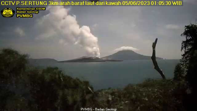
An eruption of Mount Anak Krakatau occurred on Tuesday, June 06, 2023 at 2:34 p.m. WIB with an ash column height observed at ± 500 m above the peak (± 657 m above sea level). The ash column was observed to be gray with a thick intensity, oriented northwest. This eruption was recorded on a seismograph with a maximum amplitude of 46 mm and a duration of 80 seconds.
VOLCANO OBSERVATORY NOTICE FOR AVIATION – VONA
Issued : June 06 , 2023
Volcano : Anak Krakatau (262000)
Current Aviation Colour Code : ORANGE
Previous Aviation Colour Code : orange
Source : Anak Krakatau Volcano Observatory
Notice Number : 2023KRA052
Volcano Location : S 06 deg 06 min 07 sec E 105 deg 25 min 23 sec
Area : Lampung, Indonesia
Summit Elevation : 502 FT (157 M)
Volcanic Activity Summary :
Eruption with volcanic ash cloud at 07h34 UTC (14h34 local).
Volcanic Cloud Height :
Best estimate of ash-cloud top is around 2102 FT (657 M) above sea level or 1600 FT (500 M) above summit. May be higher than what can be observed clearly. Source of height data: ground observer.
Other Volcanic Cloud Information :
Ash cloud moving to northwest. Volcanic ash is observed to be gray. The intensity of volcanic ash is observed to be thick.
Remarks :
Eruption recorded on seismogram with maximum amplitude 46 mm and maximum duration 80 second.
Source : Magma Indonésie.
Italy / Sicily , Etna :
WEEKLY BULLETIN, from May 29, 2023 to June 04, 2023. (issue date June 06, 2023)
ACTIVITY STATUS SUMMARY
In the light of the monitoring data, it is highlighted:
1) VOLCANOLOGICAL OBSERVATIONS: Degassing activity at the summit craters, in particular continuous degassing at the Bocca Nuova crater (BN) and at the Southeast crater (CSE).
2) SEISMOLOGY: The seismicity of the week was characterized by the occurrence of a swarm of earthquakes which, from 4:24 p.m. (UTC) on June 4, affected the middle western slope of the volcano with a focal volume located at a depth between 16 and about 23 km.
The average amplitude of the volcanic tremor remained at medium-low values throughout the week.
3) INFRASOUNDS: Fairly high rate of occurrence of events, especially in the first three days of the week. The events were mainly located in the area between the Bocca Nuova and Voragine craters and subordinate to the Southeast crater.
4) GROUND DEFORMATIONS: Ground deformation monitoring networks show no significant variations.
5) GEOCHEMISTRY: SO2 flux at medium-low level
CO2 fluxes settle on medium-high outgassing values
There are no updates on the Helium isotope ratio.
The partial pressure of dissolved CO2 does not show any significant variations.
6) SATELLITE OBSERVATIONS: Thermal activity observed by satellite was generally weak to moderate.
VOLCANOLOGICAL OBSERVATIONS
During the week, monitoring of Etna’s activity was carried out through the surveillance cameras of the INGV – Osservatorio Etneo. Throughout the period, sightings were intermittent due to heavy cloud cover.
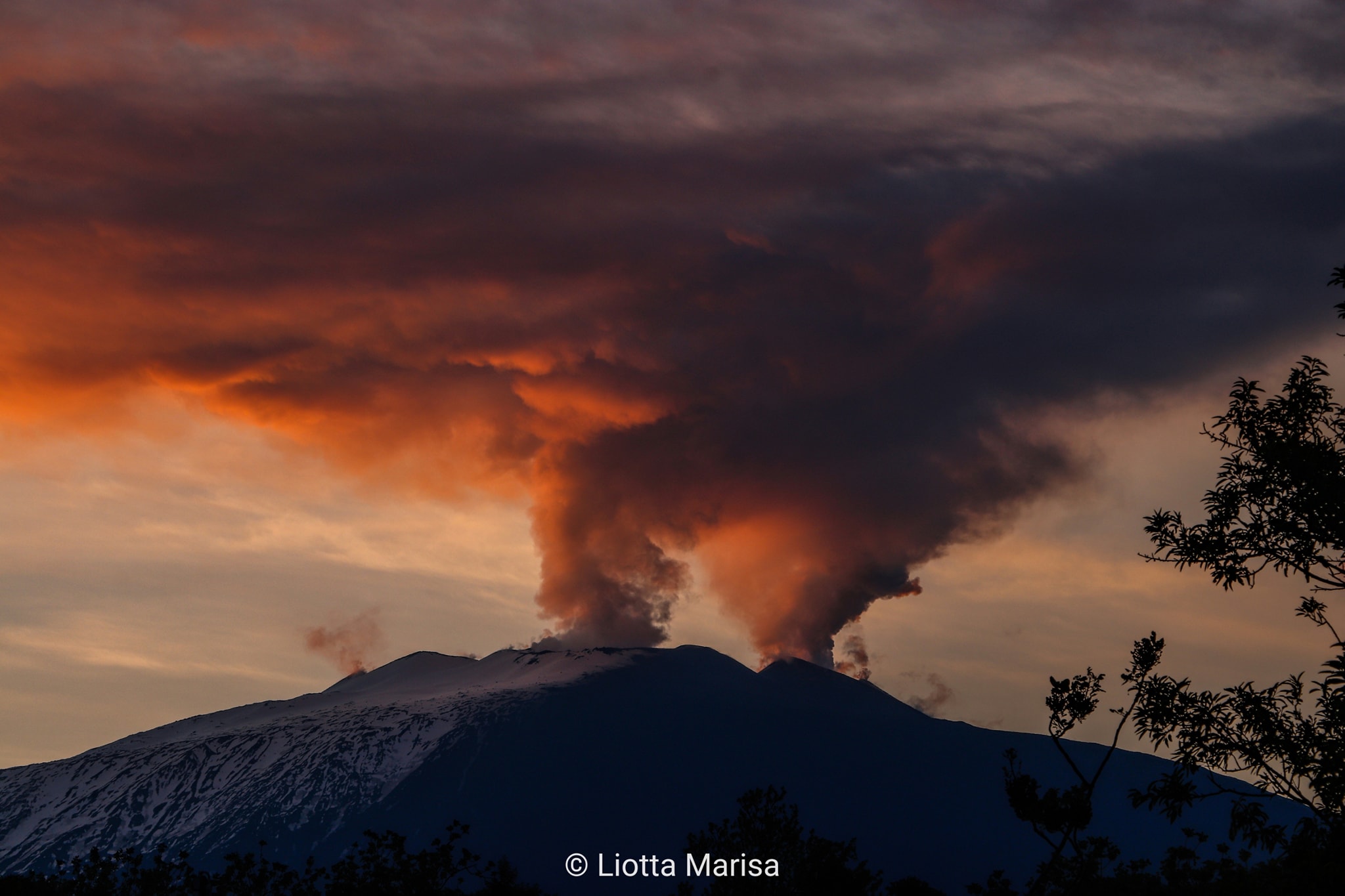
During the week of observation, the volcanic activity of Etna was characterized by a variable level degassing of the summit craters, in particular the crater of Bocca Nuova (BN), which continued to feed an uninterrupted degassing sometimes pulsating and from the Southeast Crater (CSE), which produced continuous degassing presumably from the eruptive vent of May 21, 2023 and localized fumarolic degassing along the crater rim.
The Northeast Crater (NEC) showed weak degassing from active fumaroles along the crater rim.
Source : INGV.
Photo : Liotta Marisa.
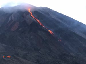
Italy , Stromboli :
WEEKLY BULLETIN, from May 29, 2023 to June 04, 2023. (issue date June 06, 2023)
ACTIVITY STATUS SUMMARY
In the light of the monitoring data, it is highlighted:
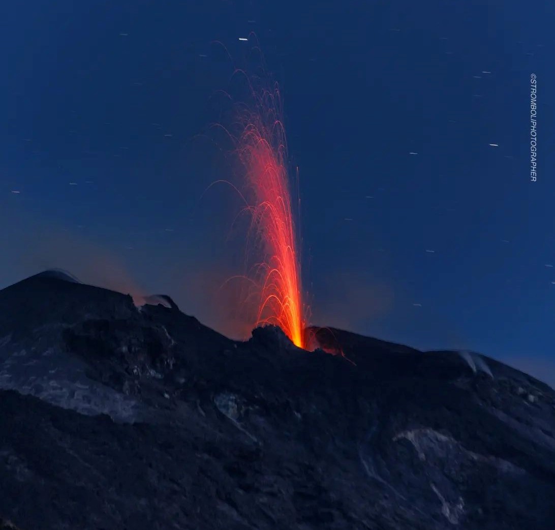
1) VOLCANOLOGICAL OBSERVATIONS: During this period, normal Strombolian activity was observed with splashing activity in sector C. The total hourly frequency of explosions fluctuated around average values (7-10 events/h). The intensity of the explosions was mainly low and medium in both the North Crater area and the Center-South Crater area.
2) SEISMOLOGY: The seismological parameters monitored do not show any significant variations.
3) GROUND DEFORMATIONS: Ground deformation monitoring networks show no significant variations.
4) GEOCHEMISTRY: The flow of SO2 is placed at an average level
There are no updates on CO2 flux data in the Pizzo area
There are no C/S data updates in the plume.
There is no update on the isotope ratio of helium in groundwater.
5) SATELLITE OBSERVATIONS: The thermal activity observed from the satellite was generally weak.
VOLCANOLOGICAL OBSERVATIONS
During the observation period, the eruptive activity of Stromboli was characterized by analyzing the images recorded by the INGV-OE surveillance cameras at an altitude of 190 m (SCT-SCV) and the Pizzo sopra la Fossa (SPT). The explosive activity was mainly produced by two eruptive vents located in the North zone of the crater and by five vents located in the Center-South zone.
Due to the unfavorable weather conditions of June 2, the visibility of the crater area was insufficient for a correct description of the eruptive activity.
Observations of explosive activity captured by surveillance cameras
In the northern zone of the crater (N), characterized by a vent located in the N1 sector and one in the N2 sector, an explosive activity was observed of variable intensity from low (the eruptive products reached a height of less than 80 m ) to medium (eruptive products reached a height of less than 150 m) in both sectors. The eruptive products consisted mainly of coarse materials (bombs and lapilli), sometimes mixed with fine materials (ash). The average frequency of explosions in the North zone fluctuates between 2 and 5 events/h.
Within the Center-South (CS) zone, the S1 sector showed high pressure degassing sometimes associated with the emission of coarse materials, while the C sector showed sporadic spattering activity (sometimes intense during the days May 29 and 30), and explosive with emissions of coarse matter. Sector S2, characterized by three active vents, mainly showed low and medium intensity explosive activity, emitting coarse materials mixed with fine materials. Overall, the average frequency of explosions in the CS zone fluctuated between 3 and 6 events/h
Source : INGV.
Photo : Stromboli Stati d’animo.
Colombia , Chiles / Cerro Negro :
Weekly activity bulletin of the volcanic complex of Chiles and Cerro Negro (CVCCN)
Regarding the monitoring of the activity of the VOLCANOES CHILES AND CERRO NEGRO, the MINISTRY OF MINES AND ENERGY through the COLOMBIAN GEOLOGICAL SERVICE (SGC) informs that:
The assessment of activity over the period from May 30 to June 5, 2023 shows a decrease in both occurrence and energy released. The predominant seismicity continues with the occurrence of earthquakes associated with the fracture of the rock and, to a lesser extent, the recording of events related to the movement of fluids, both within the volcanic system.
Most of the fracture earthquakes were located south of the Chiles volcano, at distances less than 4 km, with depths up to 5 km from its summit (level 4700 m) and a maximum magnitude of 2.5 . For the period assessed, no felt earthquakes were reported.

The soil deformation processes recorded by the sensors installed on the volcanoes persist, as well as by the use of remote satellite sensors.
The possibility of earthquakes of considerable energy that can be felt by the inhabitants of the zone of influence is not excluded.
The activity level of volcanoes remains at the YELLOW LEVEL ■ (III): CHANGES IN THE BEHAVIOR OF VOLCANIC ACTIVITY
Source : SGC
Photo : IGEPN
Iceland , Bárðarbunga :
Just after midnight on June 5, a magnitude 3.4 earthquake was measured in the eastern Bárðarbunga caldera. On the night of June 4, an M2.8 was measured there along with several smaller earthquakes. Earthquakes of this magnitude and larger are not uncommon under Bárðarbunga. At 03:17 this evening a magnitude 3.1 earthquake was measured 3km west of Surtsey. Earthquakes of this magnitude are known in this region. Since 1991, there have been about 150 earthquakes in this region, including 6 earthquakes of magnitude 3 or greater. This earthquake is the largest in this region since 2019, when a magnitude 3.4 earthquake was measured.
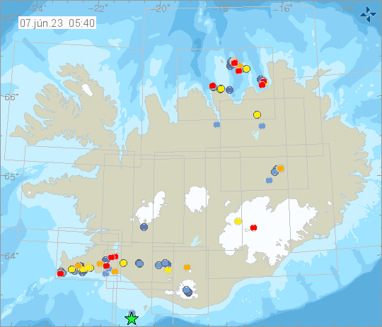
Weekly Preview, May 29-June 4, Week 22.
During week 22, 584 earthquakes were located on the IMO seismic network. This is slightly less than the previous week when 635 earthquakes were detected. The largest event of the week was a magnitude of 3.1 around noon on May 30, located on the western shore of Lake Kleifarvatn. Seismic activity around Lake Kleifarvatn is common, but last week’s earthquake was the largest in this area so far this year. Seismic activity was notable in the caldera of Torfajökull and its surroundings (23 earthquakes) as well as west of Mount Litli Hrútur (38 earthquakes) near Fagradalsfjall and in the ocean area east of Grimsey (93 earthquakes). Other seismic activity has occurred in commonly known locations within some of the major volcanoes and on known fractures and fracture zones.
Source et photo : IMO