May 10 , 2024.
Iceland : Reykjanes Peninsula :
No activity in the crater. This eruption is over. The likelihood of another magma flow and eruption continues to increase.
Updated May 9, 2024 at 8:05 a.m.
No activity in the crater for almost 24 hours
This eruption is over
Land uprising continues in Svartsengi
The rate of magma accumulation remains similar to that of recent weeks
The likelihood of another magma flow and eruption continues to increase
Warning of new eruption could be very short
Risk assessment unchanged for the moment
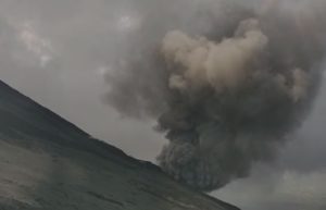
Civil defense experts flew over the Sundhnúk eruption centers last night with a drone and no activity was observed in the crater. The eruption had subsided yesterday and no lava flows were visible from the crater last night. This eruption, which lasted almost 54 days, is over.
From the Civil Defense surveillance flight last night, no spattering of lava was visible in the crater, although smoke continued to rise from it. (Photo: Civil Defense)
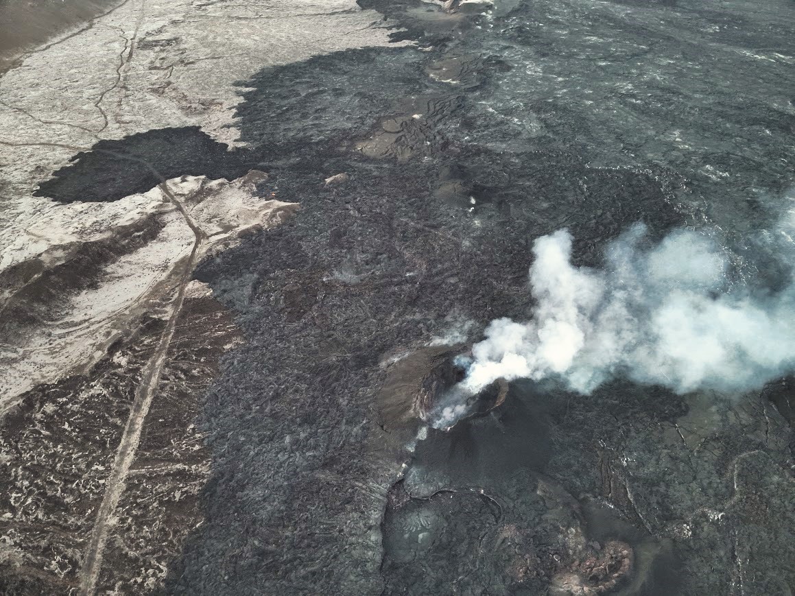
However, magma accumulation continues beneath Svartsengi, and model calculations assume that approximately 13 million cubic meters of magma have been added to the magma chamber since the eruption began on March 16. Therefore, it should be considered likely that magma will soon return from the magma chamber beneath Svartsengi towards the Sundhnúks crater series.
The Icelandic Meteorological Agency will closely monitor the situation in the eruption centers, but for now the risk assessment remains unchanged.
Source : Vedur is
Photo : Défense Civile Islandaise.
Colombia , Nevado del Ruiz :
Weekly activity bulletin: Nevado del Ruiz Volcano
Regarding the monitoring of the activity of the NEVADO DEL RUIZ VOLCANO, the COLOMBIAN GEOLOGICAL SERVICE (SGC), an entity attached to the MINISTRY OF MINES AND ENERGY, reports that:
In the week of April 30 to May 6, 2024, the volcano continued with unstable behavior. Compared to the previous week, the main variations in the parameters monitored were:
– Seismicity linked to fluid dynamics within volcanic conduits has maintained similar levels in the number of recorded earthquakes and increased in the seismic energy released. Some seismic signals were associated with pulsatile emissions of ash and gas into the atmosphere.
These seismic signals had varying energy levels with values ranging from low to moderate. Long period type signals were occasional. Despite the persistent conditions of heavy cloudiness in the volcanic area, thanks to the cameras used to monitor the volcano, it was possible to confirm some ash emissions and temperature changes of the emitted materials associated with some of these seismic events.

– Seismic activity associated with the fracturing of rocks within the volcanic edifice has maintained similar levels in the number of earthquakes recorded and in the seismic energy released. The earthquakes were located in the Arenas crater and on the different flanks of the volcano, mainly at distances less than 5 km from the crater. Seismicity showed a greater concentration of earthquakes in the crater itself and in the eastern sector. The depths of the events varied between less than 1 and 6 km from the volcano summit. The highest magnitude of the week was 1.2, corresponding to the earthquake recorded on May 1 at 6:42 p.m. in the Arenas crater, at a depth of about 2 km.
Furthermore, the recording of seismicity linked to the activity of the lava dome (protuberance or mound) located at the bottom of the crater continued, with low energy levels. This type of seismicity increased its recurrence during the week.
From the SGC we call on people who visit the Los Nevados National Natural Park not to approach the areas closest to the Arenas crater, where access is restricted, due to the persistence of thermal anomalies, the activity linked to the lava dome and frequent emissions of gas and ash which make this sector of the park dangerous for the life and integrity of people. Likewise, it is recommended not to make prolonged stops on the Murillo – Cerro Gualí route, especially in the canyons of the Gualí, Azufrado and Lagunilla rivers, which have their source on the volcano, since they are in the area of high volcanic threat.
Source : SGC
Photo : El Vulcanoso
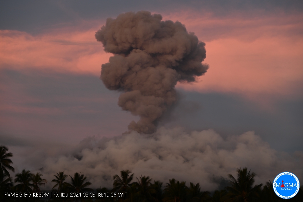
Indonesia , Ibu :
An eruption of Mount Ibu occurred on Thursday, May 9, 2024 at 6:35 p.m. WIT with the height of the ash column observed at ±1,200 m above the summit (±2,525 m above sea level) . The ash column was observed to be gray with thick intensity, oriented towards the East. This eruption was recorded on a seismograph with a maximum amplitude of 10 mm and a duration of 277 seconds.
Seismicity observation:
27 emission earthquakes with an amplitude of 2 to 24 mm and earthquake duration of 14 to 35 seconds.
1 Tornillo type earthquake with an amplitude of 12 mm and an earthquake duration of 32 seconds.
68 Shallow volcanic earthquakes with an amplitude of 2 to 28 mm and an earthquake duration of 4 to 16 seconds.
5 deep volcanic earthquakes with an amplitude of 2-3 mm, and duration of the earthquake 5-7 seconds.
2 distant tectonic earthquakes with an amplitude of 4-6 mm, and the duration of the earthquake was 54-78 seconds.
RECOMMENDATION
1. Communities around Mount Ibu and visitors/tourists should not carry out activities within a radius of 3 km, with a sectoral extension of 5 km towards the crater opening in the northern part of the active Mount Ibu crater .
2. In the event of ash falling, people who practice activities outside the home are advised to protect their nose, mouth (mask) and eyes (glasses).
Source et photo : Magma Indonésie
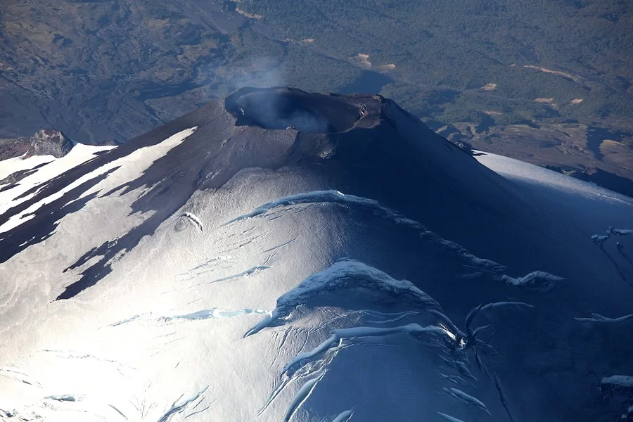
Chile , Villarica :
Special Report on Volcanic Activity (REAV), Auracania region, Villarica volcano, May 9, 2024, 7:30 p.m. local time (mainland Chile).
The National Service of Geology and Mines of Chile (Sernageomin) publishes the following PRELIMINARY information, obtained using the monitoring equipment of the National Volcanic Monitoring Network (RNVV), processed and analyzed at the Southern Andean Volcanological Observatory ( Ovdas):
On Thursday May 9, 2024, at 7:18 p.m. local time (11:18 p.m. UTC), monitoring stations installed near the Villarica volcano recorded an earthquake associated with the fracturing of rocks (volcano-tectonic).
The characteristics of earthquakes after their analysis are as follows:
ORIGINAL TIME: 7:18 p.m. local time (11:18 p.m. UTC)
LATITUDE: 39.418° S
LONGITUDE: 71.911°E
DEPTH: 4.4 km
LOCAL MAGNITUDE: 3.1 (ML)
OBSERVATIONS:
The technical volcanic alert remains at the Yellow level.
Source Sernageomin.
Photo : Aton
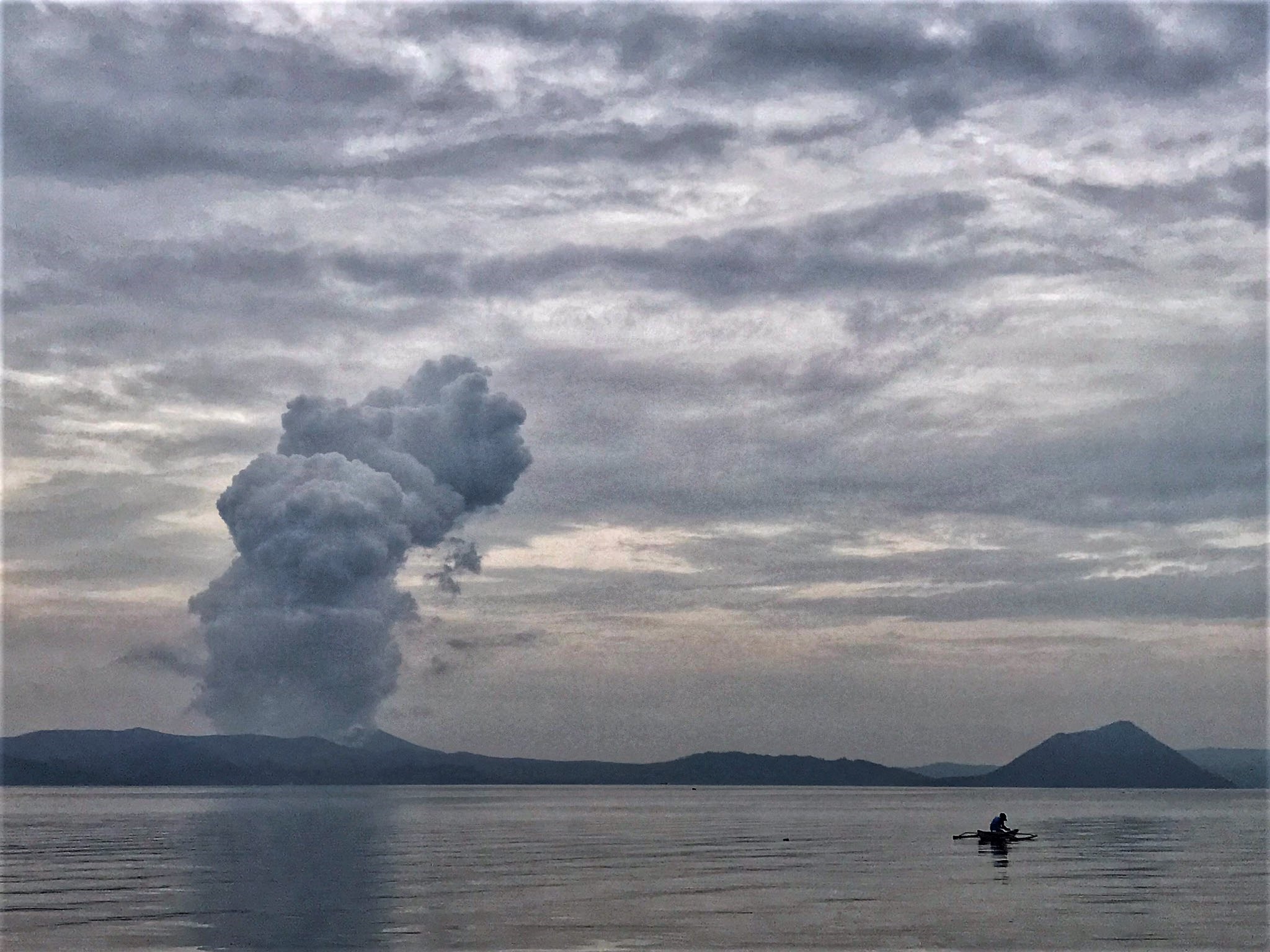
Philippines , Taal :
TAAL VOLCANO ADVISORY , 10 May 2024 , 09:00 AM
This is a notice of weak phreatic activity at Taal Volcano.
Four (4) minor successive phreatic or steam-driven eruptions at the Taal Main Crater occurred this morning between 7:03 AM to 07:09 AM, 07:17 AM to 07:18 AM, 07:52 AM to 07:54 AM and 07:57AM to 08:00 AM based on visual observations. The event produced white steam-laden plumes that rose between 100 and 300 meters above the Main Crater before drifting southwest based on IP camera monitors. Sulfur dioxide (SO2) emissions slightly increased yesterday, 9 May 2024 at 2,346 tonnes/day. Average SO2 emissions since January this year remain high at 8,766 tonnes/day. Weak phreatic activity is likely driven by the continued emission of hot volcanic gases at the Taal Main Crater and could be succeeded by similar events. The background levels of volcanic earthquake activity and ground deformation detected at Taal indicate that unrest is unlikely to progress into magmatic eruption.
DOST-PHIVOLCS reminds the public that Alert Level 1 prevails over Taal Volcano, which means that it is still in abnormal condition and should not be interpreted to have ceased unrest nor ceased the threat of eruptive activity. At Alert Level 1, sudden steam-driven or phreatic explosions, volcanic earthquakes, minor ashfall and lethal accumulations or expulsions of volcanic gas can occur and threaten areas within TVI. Furthermore, degassing of high concentrations of volcanic SO2 continues to pose the threat of potential long-term health impacts to communities around Taal Caldera that are frequently exposed to volcanic gas. DOST-PHIVOLCS strongly recommends that entry into TVI, Taal’s Permanent Danger Zone or PDZ, especially the vicinities of the Main Crater and the Daang Kastila fissure, must remain strictly prohibited. Local government units are advised to continuously monitor and assess preparedness of their communities and undertake appropriate response measures to mitigate hazards that could be posed by long-term degassing and related phreatic activity. Civil aviation authorities must advise pilots to avoid flying close to the volcano as airborne ash and ballistic fragments from sudden explosions and wind-remobilized ash may pose hazards to aircrafts.
Source : Phivolcs
Photo : Rizal M ( archive).