May 03 , 2024.
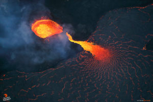
La Réunion , Piton de la Fournaise :
Monthly bulletin, Paris Institute of Globe Physics, Piton de la Fournaise volcanological observatory: April 2024.
Seismicity
In April 2024, the OVPF-IPGP recorded in total at the Piton de la Fournaise massif:
• 32 superficial volcano-tectonic earthquakes (0 to 2.5 km above sea level) under the summit craters;
• 3 deep earthquakes (below sea level);
• 75 long-period earthquakes;
• 285 landslides.
After an increase in seismicity in March 2024, the month of April 2024 was marked by low seismicity under the Piton de la Fournaise with only 32 superficial volcano-tectonic earthquakes and 3 deep earthquakes recorded.
Only 6 superficial volcano-tectonic earthquakes and 1 deep earthquake could be located, respectively under the Dolomieu crater and under the eastern flank. The others – of lower magnitudes – could not be located. Numerous (263) landslides in the Dolomieu Crater, at the Cassé de la Rivière de l’Est and at the level of recent lava flows were also recorded.
Deformation
After a recovery in February 2024, the inflation of the building stopped at the beginning of April 2024. Since then, no significant ground movement has been recorded on the GNSS network.
Balance sheet
In April 2024, seismicity remained low – with only 32 superficial volcano-tectonic earthquakes recorded under the summit craters – and the inflation of the edifice stopped.
This shows that magmatic recharge and pressurization of the surface magma reservoir have ceased.
Note that since 2016, the replenishment of the superficial magmatic reservoir under the Piton de la Fournaise has taken place in pulses, thus such phases of calm in deformations and seismicity have already been observed on several occasions between 2016 and 2023 over periods ranging from 15 days to several months.
Source et photo : OVPF
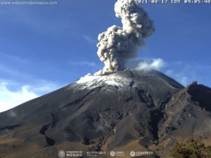
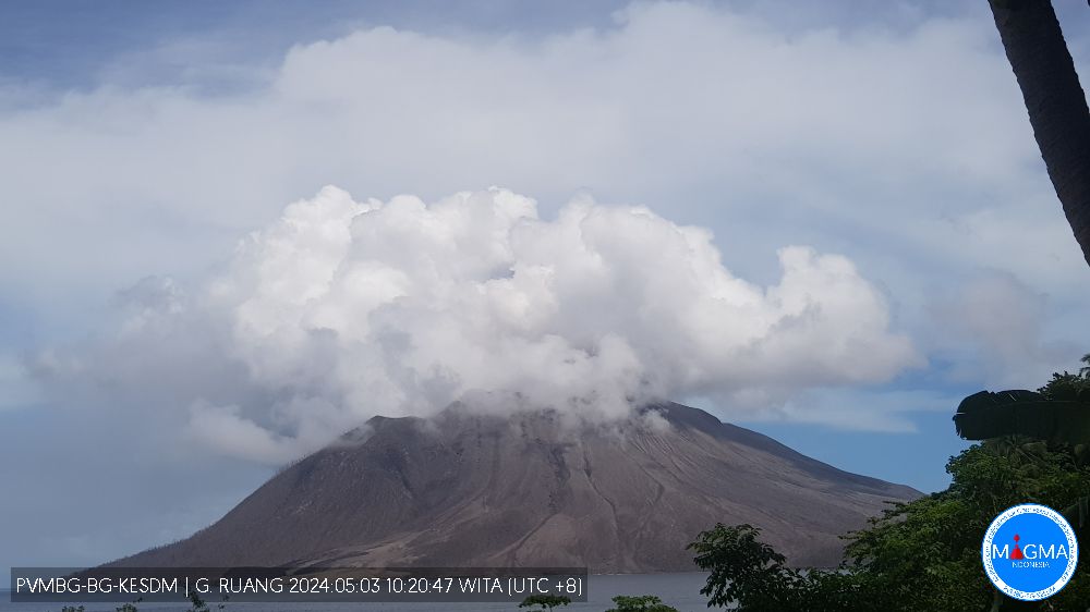
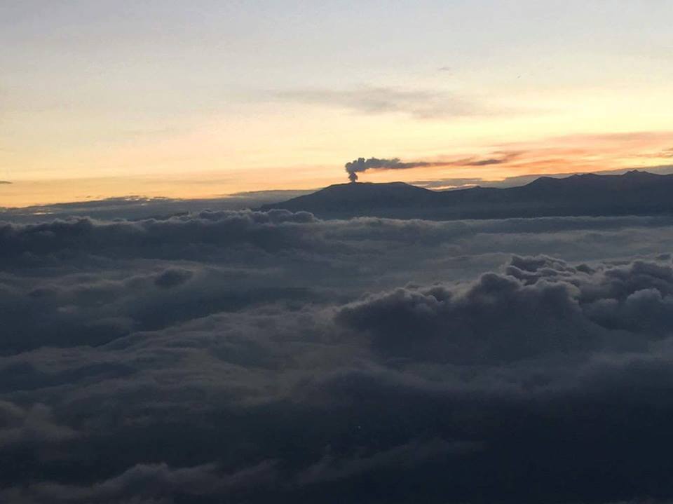
Indonesia , Ruang :
Press release on Ruang volcano activity, May 2, 2024.
The latest developments in G. Ruang’s activities until May 2, 2024 are as follows:
After the explosive eruption on April 17, 2024, eruptive activity decreased. On April 22, 2024 at 09:00 WITA, the activity level of G. Ruang was lowered from level IV (AWAS) to level III (SIAGA).
The earthquakes from April 29, 2024 until 24:00 WITA recorded via the RAPS station were: 15 avalanche earthquakes, 237 shallow volcanic earthquakes, 425 deep volcanic earthquakes, 15 local tectonic earthquakes and 6 distant tectonic earthquakes. Smoke from the crater was observed up to 200/1000 m above the summit with a thick white color. At 17:02 WITA, a weak eruption was observed with smoke coming from the crater up to 1,000 m from the summit.
On April 30, 2024 at 01:15 WITA, an eruption occurred, starting with a tremor felt as far away as Tagulandang Island, with a gray, medium-to-thick eruption column tilted toward the North. The height of the eruptive column reached 2,000 m above the summit. The activity level of G. Ruang was increased from level III (SIAGA) to level IV (AWAS) at 01:30 WITA, with a recommended danger distance within a radius of 6 km. At 09:00 WITA, the recommended danger distance was extended to 7 km.
On April 30, 2024 at 02:32 WITA, there was another eruption followed by a roar. The height of the eruption column was not observed due to the dark conditions. It was reported that stone showers occurred at the Ruang PGA post in P. Tagulandang. The eruption lasted until 04:30 WITA. G. Ruang’s seismic monitoring equipment (RAPS) was damaged. At 08:35 WITA, an eruption was observed accompanied by flows of hot clouds which reached the sea in the northeastern sector of the island. The eruption column reaches 5,000 m above the summit, gray to black in color, thick intensity, oriented towards the East and the South.
Seismicity on May 1, 2024 was dominated by continuous tremors, although 3 deep volcanic earthquakes and 10 shallow volcanic earthquakes were recorded. An eruption occurred on May 1, 2024 at 5:43 p.m. WITA with the height of the ash column observed at ±600 m above the peak. The ash column was observed to be white to gray in color, with medium to thick intensity, oriented towards the North.
The seismicity from May 2, 2024 until 09:00 WITA was still dominated by continuous tremors. 4 shallow volcanic earthquakes, 2 local tectonic earthquakes and 2 deep tectonic earthquakes were recorded. The smoke from the crater was observed to be white and gray in color, medium to thick and high in intensity in the range of 300 to 500 m above the crater summit.
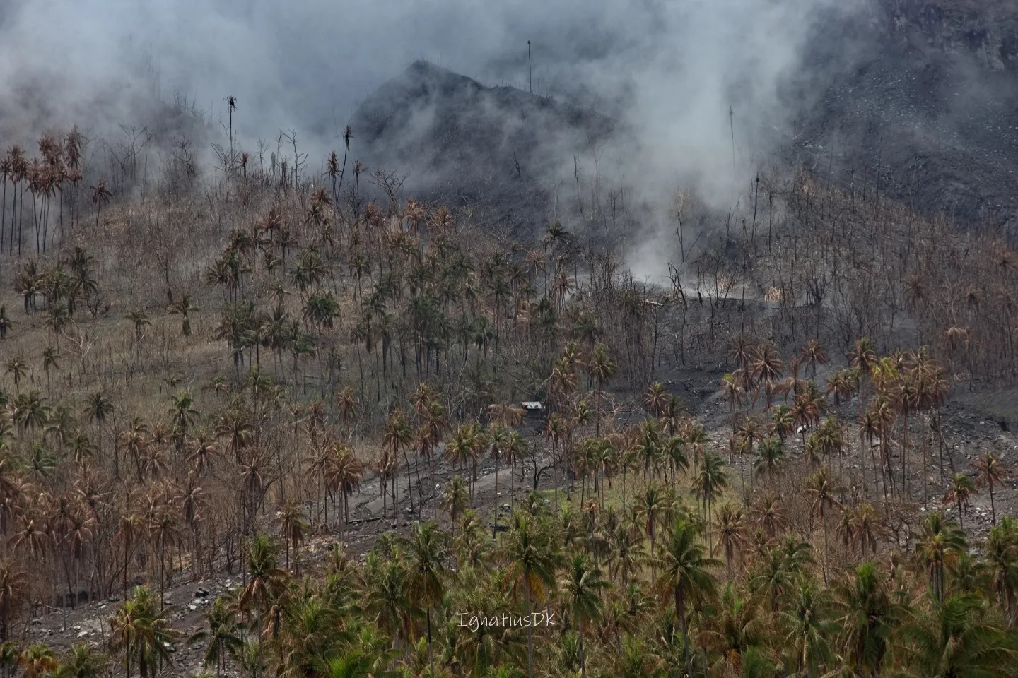
Even though the number of earthquakes seems to be decreasing, the PGA G. Ruang Post (PRUA) station is located 5 km from the active crater, so the sensitivity is not as good as the RUA3 stations (1.5 km from the active crater) and RAPS (2.7 km from the active crater) which is located on the island. Both stations were damaged after the eruption on April 17, 2024 and April 30, 2024. Apart from that, the smoke is still gray in color with thick intensity and height 500-700 m above the peak, this still indicates that the activity of G. Ruang is still high.
Current potential hazards include eruptions producing hot clouds, ejections of incandescent material, and exposure to volcanic ash that depend on wind direction and speed, and lahars in heavy rains around Mount Ruang.
Based on the results of visual and instrumental monitoring, the volcanic activity of Mount Ruang is still high and is set at level IV (AWAS) with the following recommendations:
Communities around Mount Ruang and visitors/tourists should remain vigilant and not enter the area within a 7 km radius from the center of the active crater of Mount Ruang
People living in the P. Tagulandang area within a 7 km radius should be immediately evacuated to a safe location outside the 7 km radius.
Residents of Tagulandang Island, especially those living near the coast, should be aware of the potential for emitting glowing rocks and hot clouds (surges).
Source : PVMBG
Photos : PVMBG , Dwikoen Sastro
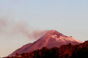
Colombia , Nevado del Ruiz :
Weekly activity bulletin: Nevado del Ruiz Volcano
Regarding the monitoring of the activity of the NEVADO DEL RUIZ VOLCANO, the MINISTRY OF MINES AND ENERGY, through the COLOMBIAN GEOLOGICAL SERVICE (SGC), reports that:
In the week of April 23-29, 2024, the volcano continued with unstable behavior. Compared to the previous week, the main variations in the parameters monitored were:
– Seismic activity associated with the fracturing of rocks inside the volcanic edifice has decreased in the number of earthquakes recorded and increased in the seismic energy released. The earthquakes were located in the Arenas crater and on the north, northeast, south-southwest and southeast flanks of the volcano, at distances mainly less than 6 km from the crater. The depths of the events varied between less than 1 and 9 km from the volcano summit. The earthquakes were of low energy level (magnitudes less than 1). The highest magnitude of the week was 1.0, corresponding to the earthquake recorded on April 29 at 4:49 a.m. in the Arenas crater, at a depth of about 2 km.
Furthermore, the recording of seismicity linked to the activity of the lava dome (protuberance or mound) located at the bottom of the crater continued, with low energy levels. This type of seismicity has significantly decreased.
– Seismicity linked to fluid dynamics inside volcanic conduits has decreased in the number of earthquakes recorded and in the seismic energy released. These seismic signals exhibited variable energy levels with values ranging from low to moderate, and most of them were associated with pulsatile emissions of ash and gas into the atmosphere. Long-lasting signals were occasional. Despite the persistent conditions of high cloudiness in the volcanic area, thanks to the cameras used to monitor the volcano, it was possible to confirm some ash emissions and temperature changes of the emitted materials associated with some of these seismic events.
– On the volcano, the emission of water vapor and gas into the atmosphere from the Arenas crater continues.
Sulfur dioxide (SO2) outgassing rates were variable and increased compared to the previous week. The maximum height of the gas column was 1,400 m vertically and 1,600 m dispersed. These values were estimated at the summit of the volcano on April 27, 28 and 29. The direction of dispersion of the gas column was variable with a preferential trend towards the northwest flank of the volcano.
– When monitoring surface activity from satellite monitoring platforms, weather conditions (e.g. heavy cloudiness) limited the detection of thermal anomalies at the bottom of Arenas crater. It was only this week that an anomaly report with a low energy level was obtained.
Source : SGC
Photo : Diana M Bustamante.
Hawaii , Kilauea :
Thursday, May 2, 2024, 8:49 AM HST (Thursday, May 2, 2024, 18:49 UTC)
19°25’16 » N 155°17’13 » W,
Summit Elevation 4091 ft (1247 m)
Current Volcano Alert Level: ADVISORY
Current Aviation Color Code: YELLOW
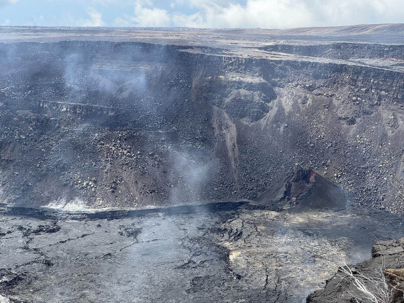
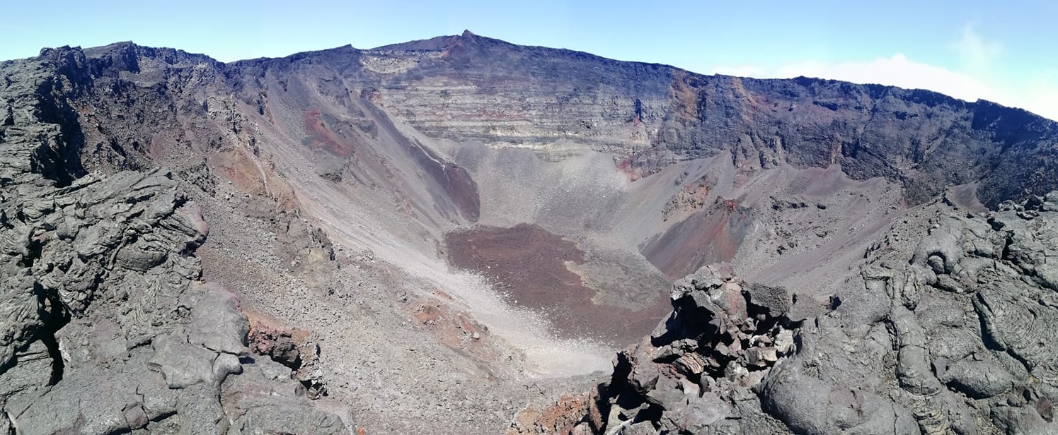
This photo shows the southwest portion of Kaluapele (Kīlauea’s summit caldera). In the lower right corner of the image is the cone formed during the June 2023 eruption. This cone hosted impressive lava fountaining that supplied lava through a narrow channel into the lava pond in the lower left portion of the image.
Activity Summary:
Kīlauea volcano is not erupting. Elevated seismicity beneath the upper East Rift Zone and caldera south of Halemaʻumaʻu that began on April 27 continues.
Summit and upper East Rift Zone Observations:
An increase in earthquake activity began just after midnight on April 27 beneath the upper East Rift Zone and beneath Kīlauea caldera south of Halemaʻumaʻu. Over the past few days, earthquake locations have been focused primarily between the southeast side of Kīlauea caldera beneath Keanakākoʻi crater and the intersection with Hilina Pali Road. The number of earthquakes is similar to yesterday with approximately 270 earthquakes in this area over the past 24 hours. However, since midnight hourly earthquake activity has increased from 10-12 earthquakes per hour to 12-15 earthquakes per hour with most of the activity southeast of Puhimau crater. Depths remain concentrated between 2-3 km (1.2-1.9 miles) beneath the surface with scattered shallower earthquakes. There have been few earthquakes in the caldera south of Halemaʻumaʻu over this same period. Earthquake magnitudes in both areas have not exceeded M3.0 in the past 24 hours, with the vast majority below M2.0. Since the start of the unrest, there have been over 1500 earthquakes beneath the upper East Rift Zone and approximately 225 earthquakes beneath the southern end of Kīlauea caldera.
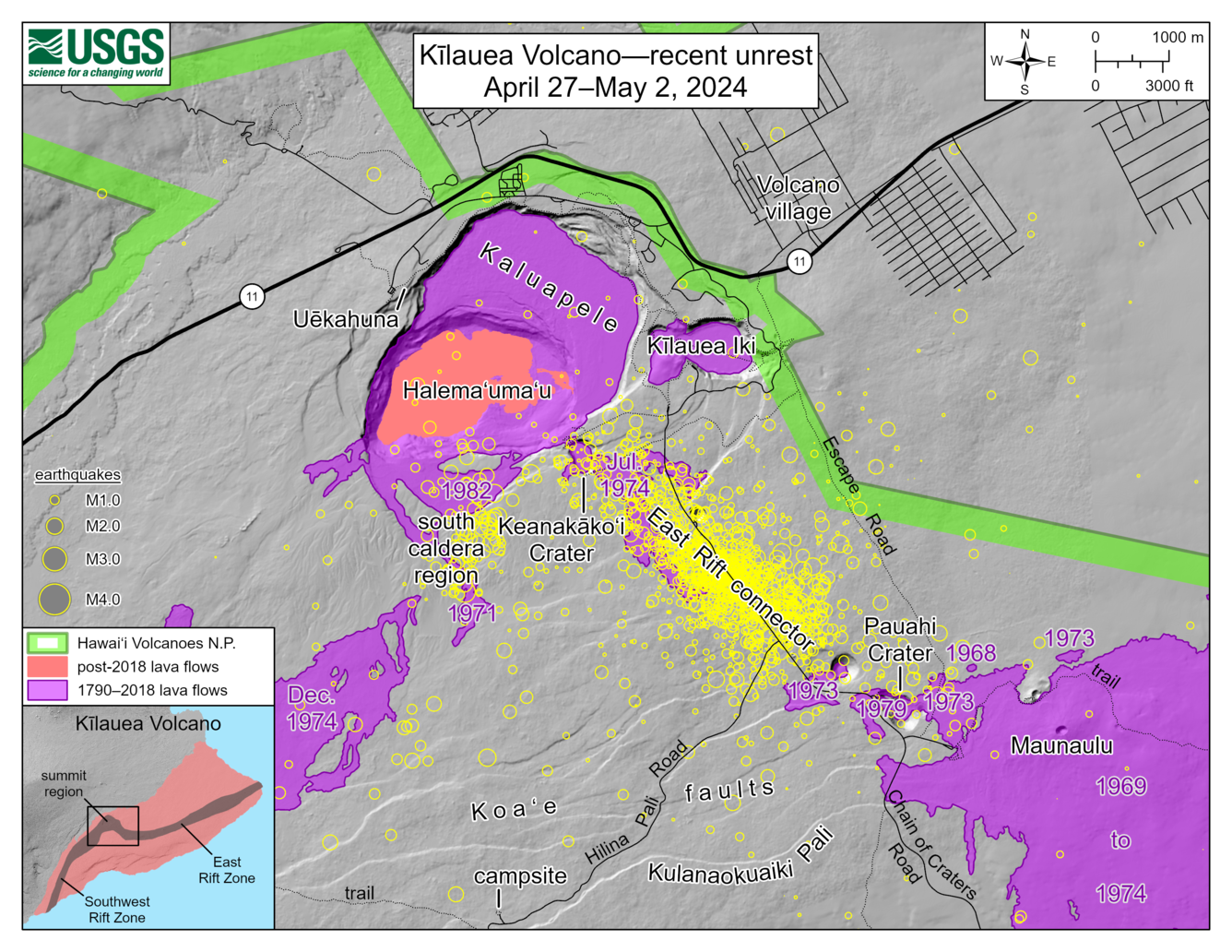
This map depicts recent unrest at Kīlauea volcano. Yellow circles mark the locations of approximately 1,600 earthquakes that have occurred between April 27 and May 2, 2024, as the upper East Rift Zone reacts to pressurization of magma chambers beneath the summit region of Kīlauea. Most earthquakes have been smaller than magnitude-2, with locations clustering in an area known as the upper East Rift Zone or East Rift connector. The upper East Rift Zone area saw several eruptions in the 1960s and 1970s, which are labelled and shown in purple. Most recently, in November 1979, a brief one-day eruption occurred in and near Pauahi crater. In July of 1974, a three-day-long eruption began in Keanakāko‘i Crater, with east-west oriented fissures subsequently opening within Kaluapele and southeast towards Luamanu Crater. A month-long eruption in November 1973 extended from Pauahi Crater east towards Pu‘uhuluhulu. And, a day-long eruption in May 1973 extended from about a half a mile (1 km) west of Hi‘iaka to Pauahi Crater.
Ground deformation continues with ongoing uplift at the summit and south of the caldera into the Southwest Rift Zone. Around 1:00 PM yesterday, the tilt signal at Uēkahuna turned over to inflation as part of a deflation-inflation (DI) event that began on 29 April at 6:00 PM. Inflation slowed at around 9 PM and continues at this rate this morning. The Sand Hill tiltmeter continues to record steady inflation of the south end of the caldera and increased slightly around 9 PM to rates observed this morning.
Sulfur dioxide (SO2) gas emission rates remain low. An SO2 emission rate of approximately 52 tonnes per day was recorded on April 23.
Rift Zone Observations:
All seismic activity on the East Rift Zone is confined to the upper East Rift Zone, with no significant earthquakes occurring past the Mauna Ulu region. At this time, there are still no signs of deformation beneath the upper East Rift Zone beyond Keanakākoʻi crater. Seismicity in Kīlauea’s Southwest Rift Zone remains low overall. Measurements from continuous gas monitoring stations downwind of Puʻuʻōʻō in the middle East Rift Zone—the site of 1983–2018 eruptive activity—continue to be below detection limits for SO2, indicating that SO2 emissions Puʻuʻōʻō are negligible.
Source : HVO.
Photos : USGS / M. Patrick , HVO.
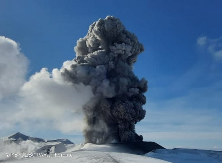
Russia / Kuril Islands , Ebeko :
VOLCANO OBSERVATORY NOTICE FOR AVIATION (VONA)
Issued: May 02 , 2024
Volcano: Ebeko (CAVW #290380)
Current aviation colour code: ORANGE
Previous aviation colour code: orange
Source: KVERT
Notice Number: 2024-25
Volcano Location: N 50 deg 41 min E 156 deg 0 min
Area: Northern Kuriles, Russia
Summit Elevation: 1156 m (3791.68 ft)
Volcanic Activity Summary:
A moderate explosive eruption of the volcano continues. According to visual data from Severo-Kurilsk, explosion sent ash up to 2.5 km a.s.l., and ash cloud drifted to the south-east of the volcano.
A moderate explosive eruption of the volcano continues. Ash explosions up to 6 km (19,700 ft) a.s.l. could occur at any time. Ongoing activity could affect low-flying aircraft and airport of Severo-Kurilsk
Volcanic cloud height:
2000-2500 m (6560-8200 ft) AMSL Time and method of ash plume/cloud height determination: 20240502/2056Z – Visual data
Other volcanic cloud information:
Distance of ash plume/cloud of the volcano: 5 km (3 mi)
Direction of drift of ash plume/cloud of the volcano: SE
Time and method of ash plume/cloud determination: 20240502/2056Z – Visual data
Source : Kvert.
Photo : L. Kotenko. IVS FEB RAS (archive)