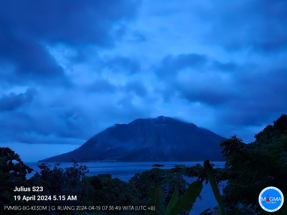
April 19 , 2024.
Indonesia , Ruang :
VISUAL OBSERVATION
The volcano is clearly visible until it is covered by fog. White smoke is observed from the crater, of medium to thick intensity, approximately 50-100 meters from the summit. Cloudy weather, light southerly wind.
OTHER INFORMATION
The equipment has been damaged since April 17, 2024 at 8:39 p.m. WITA
CLIMATOLOGY
Cloudy weather, light southerly wind. The air temperature is around 27-30°C.
RECOMMENDATION
1. Communities around Mount Ruang and visitors/tourists should remain vigilant and not enter the area within a 6 km radius around the center of the active crater of Mount Ruang.
2. People living in the P. Tagulandang area within 6 km radius should be immediately evacuated to a safe place outside the 6 km radius.
3. Residents of Tagulandang Island, especially those living near the coast, should be aware of the risk of ejected glowing rocks, hot clouds (surges), and tsunamis caused by the collapse of volcanic bodies into the sea.
4. The public is advised to always wear masks to avoid exposure to volcanic ash which can disrupt the respiratory system.
Source et photo : Magma Indonésie
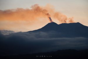
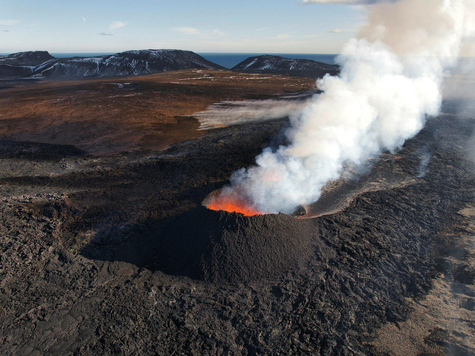
Iceland , Reykjanes Peninsula :
The uprising continues at a steady pace. The volume of the lava bed reached 33.2 million cubic meters
Updated April 18 at 1:45 p.m.
The surface area of the lava bed is 6.15 km2 and its volume is 33.2 ± 0.8 million m3
The average lava flow from the crater during the period April 8–15 was estimated at 3.2 ± 0.2 m3/s.
There is always a risk of gas pollution. Residents in the area are advised to monitor air quality.
The weather forecast for gas distribution today (Thursday) indicates a northwest direction of 3 to 8 m/s, and gas pollution from the volcanic eruption will mainly reach the southeast.
The Sundhnúk crater series erupts constantly and occurs from a crater a short distance east of Sundhnúk. The lava bed continues to accumulate near the craters, but lava also flows in closed channels about 1 km to the southeast, and there are active areas in the lava bed opposite Hagafell.

On Monday, April 15, the imaging team from the National Institute of Natural Sciences (NÍ) and the Land Survey of Iceland (LMÍ) flew over the eruption centers. The results of the measurement flight show that the area of the lava bed on April 15 was 6.15 km2 and the volume was 33.2 ± 0.8 million m3. The extent and thickness of the lava bed is shown on the map above.
The uprising in Svartsengi continues apace. This suggests that about half of the magma from deep accumulates in the magma chamber, while the other half flows to the surface in the Sundhnúks crater series.
Source : IMO
Photos : mbl.is/Hörður Kristleifsson , IMO.
Chile , Laguna del Maule
Seismology
The seismological activity of the period was characterized by the recording of:
748 seismic events of type VT (Volcano-Tectonic), associated with the fracturing of rocks. The most energetic earthquakes had a Local Magnitude (ML) value, both equal to 3.2, one of them being located 7.8 km south-southwest of the center of the lagoon and at a distance depth of 7.4 km and the next was located 8 km south-southwest of the center of the lagoon, at a depth of 7.6 km.
Fluid geochemistry
No anomalies have been reported in emissions of sulfur dioxide (SO2) into the atmosphere in the area near the volcanic complex, according to data published by the Tropopheric Monitoring Instrument. (TROPOMI) and Sulfur Dioxide Group of the Ozone Monitoring Instrument (OMI).
Geodesy
From data provided by 7 GNSS stations, which monitor the deformation of the volcanic complex, we observe that the inflationary process recorded since 2012 continues.
Particularly during the period evaluated, we note that:
– The distances between stations maintain the trends and magnitudes compared to the previous period, with lengthening/shortening rates reaching a maximum magnitude of 1.4 cm/month.
– The maximum vertical elevation is maintained in the central sector of the lagoon, with however a decrease in the rate of variation, which reaches 1.5 cm/month for this period, recorded at station MAU2.
– Thanks to satellite radar interferometry (InSAR), using Sentinel 1A images, we observe signals associated with a deformation of a magnitude and pattern similar to those previously recorded in the complex, with an area maximum inflation near the center of the lagoon.
Seismic activity continues with the recording of volcano-tectonic (VT) events with the appearance of a seismic swarm characterized by 3 events with maximum magnitudes equal to or greater than 3.0. The location of the epicenters continues mainly in the South-South-West sector of the lagoon. The process of cortical deformation continues to evolve with rhythms similar to those observed in recent years. There are no obvious surface changes related to volcanic activity. From the above, we conclude that the volcanic system always records internal activity with energy levels above its basic threshold.
In this way, the technical alert is maintained in: YELLOW TECHNICAL ALERT: Changes in the behavior of volcanic activity.
Source : Sernageomin
Photo : Claudio Arriagada
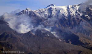
Colombia , Nevado del Ruiz :
Weekly activity bulletin: Nevado del Ruiz Volcano
Regarding the monitoring of the activity of the NEVADO DEL RUIZ VOLCANO, the MINISTRY OF MINES AND ENERGY, through the COLOMBIAN GEOLOGICAL SERVICE (SGC), reports that:
In the week of April 9 to 16, 2024, the volcano continued with unstable behavior. Compared to the previous week, the main variations in the monitored parameters
were:
– Seismicity linked to fluid dynamics inside volcanic conduits has increased in the number of earthquakes recorded and in the seismic energy released. Most seismic signals were associated with pulsatile emissions of ash and gas into the atmosphere. The energy level of these seismic signals varied from low to moderate and a longer duration was observed. Using cameras used to monitor the volcano, several ash emissions and significant changes in the temperature of emitted materials associated with some of these seismic events have been confirmed. The seismic signals from April 13 at 10:07 a.m. are highlighted for their energy level and on April 10 at 10:24 p.m. by the temperature of the material emitted.
– Seismic activity associated with the fracturing of rocks inside the volcanic edifice has decreased in the number of earthquakes recorded and in the seismic energy released. The earthquakes were located on the different flanks of the volcano, at distances less than 10 km from the crater and in the crater itself. Seismicity showed a greater concentration of events on the East-Southeast flank. The depths of the events varied between less than 1 and 8 km from the volcano summit. The highest magnitude of the week was 1.5, corresponding to the earthquake recorded on April 13 at 1:49 a.m., 2 km east-southeast of Arenas crater and at an approximate depth of 4 km.
Furthermore, the recording of seismicity linked to the activity of the lava dome (protuberance or mound) located at the bottom of the crater continued. Energy levels of this type of seismicity remained low.
The release of water vapor and gases into the atmosphere from the volcano’s crater continued. Sulfur dioxide (SO2) outgassing rates were variable and showed levels similar to those estimated the previous week. The maximum height of the gas or ash column was approximately 1,300 m in height and 1,600 m in dispersion. These values were estimated at the summit of the volcano on April 13, during the emission of ash associated with the 10:07 a.m. seismic signal. The direction of dispersion of the gas column was predominant towards the Western sector, from the North-West and South-West flank of the volcano, generating ash falls in areas close to the volcano and in certain towns located in the direction of the wind. like Manizales. and Villamaría, in the Caldas department.
– When monitoring surface activity from satellite monitoring platforms, several thermal anomalies were detected at the bottom of Arenas Crater with low to moderate energy levels.
Source et photo : SGC
Guatemala , Santiaguito :
14°44′ 33˝ North latitude;
91°34’13˝ West longitude.
Altitude: 0.2500 meters
Weather conditions: partly cloudy
Wind: northeast
Precipitation: 0.0 mm.
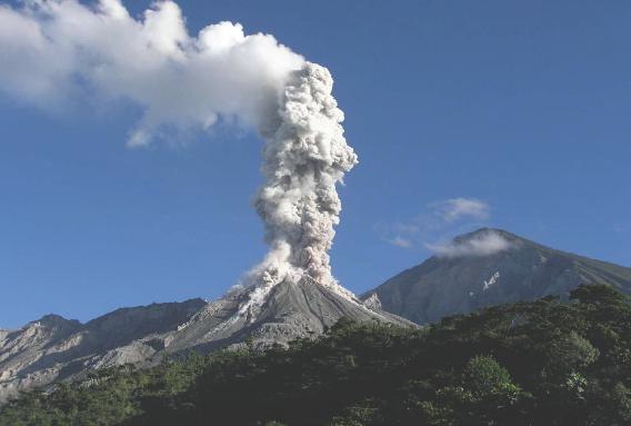
Activity:
Low to moderate degassing, constant above the Caliente Dome. Weak and moderate explosions are generated recurrently, causing incandescence and avalanches in the West, South-West, South-East and South directions. The moderate explosions form a column of gas and ash as high as 3,400 meters above sea level (10,498 feet), with said ash moving west and southwest. This activity causes the fall of fine ash particles and a foggy environment near the volcano. Strong avalanches and audible noises can be generated several kilometers from the volcanic edifice. The occurrence of block and ash flows of moderate to strong characteristics is not excluded, as well as possible pyroclastic flows over long distances in different directions.
Source : Insivumeh.
Photo : La Hora ( archive).