April 09 , 2024.
Ecador / Galapagos , Fernandina :
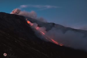
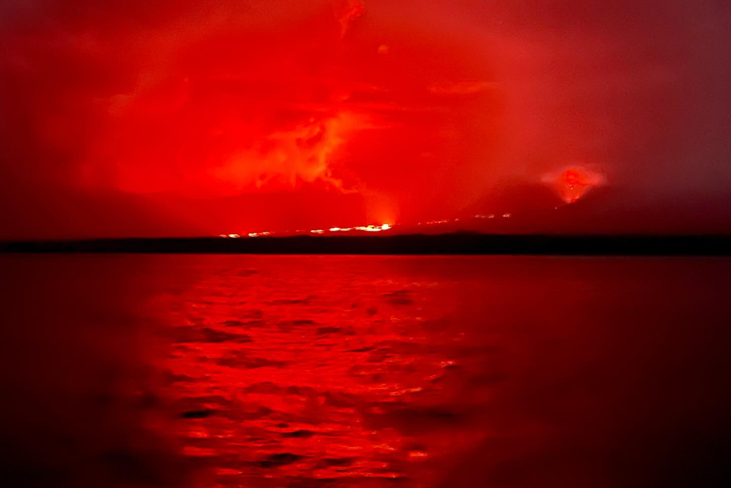
The lava flow from the eruption of the La Cumbre volcano reaches the sea
This morning, park rangers from the Directorate of the Galapagos National Park, of the Ministry of Environment, Water and Ecological Transition (MAATE), who carry out control and surveillance actions from the base of the Canal Bolívar, west of Isabela, reported that lava flows from the eruption of the La Cumbre volcano, on Fernandina Island, reached the sea, after 35 days of moderate but uninterrupted activity.
Since March 2, when the eruption began, the Archipelago Environmental Authority has been monitoring this natural event to record the changes occurring in the ecosystem; and maintains constant coordination with the Institute of Geophysics (IG), using satellite information and seismic equipment installed on the island.
For the moment, technicians estimate that the lava flow which descended the southeastern flank of the volcano affected the endemic vegetation of the area such as scalesias, palo santo and certain cacti and part of the habitable zone of the land iguana. With their arrival at the sea, through underground tunnels, it is possible that marine iguanas, fish and coastal invertebrates close to the area may be affected.
Land and marine visitation sites on Fernandina Island remain open; However, the DPNG continues to assess the situation to adopt new management measures if necessary. There is no human population on this island.
According to IG reports, Cumbre is one of the most active volcanoes in the Galapagos. Since the 1800s, it has experienced between 28 and 30 eruptions, which is the highest eruption recurrence rate in the archipelago. In recent years, similar processes were recorded in 2017, 2018 and 2020.
Gas:
The MOUNTS satellite system reported 478.4 tons of sulfur dioxide (SO2) measured on 07/04/2024 at 2:11 p.m. TL.
Other monitoring parameters:
The MIROVA-VIIRS satellite system recorded 2 high thermal anomalies, the MIROVA MODIS system recorded 4 high thermal anomalies in the last 24 hours. For its part, the FIRMS satellite system recorded 201 thermal anomalies over the last 12 hours.
Observation:
Yesterday afternoon, based on reports from park rangers from the Galapagos National Park Directorate (DPNG), Ministry of Environment, Water and Ecological Transition (MAATE), it was reported that the lava flows associated with the eruption of the La Cumbre volcano, on Fernandina Island, reached the sea. This information is also confirmed by the GOES-16 satellite system, which presents thermal anomalies along the coastal edge.
Sources : Parque Nacional Galapagos, IGEPN.
Photos : Parque Nacional Galapagos , Nancy Juan Jiang
Costa Rica , Poas :
Latitude: 10.2
Longitude: -84,233
Altitude: 2,687 meters above sea level
Activity observed:
Eruptive activity continues. However, after 9 days of continuous emission of ash, since yesterday afternoon, a decrease in it has been observed. Due to the appearance of the tremor (f = 1.5 – 4 Hz) yesterday at 12:00 p.m., it cannot be ruled out that ash emissions will increase in the future. The CO2/SO2, H2S/SO2 gas ratios as well as SO2 emissions are stable. This morning at the lookout, around 10:25 a.m., the maximum SO2 concentration was 1.2 ppm. The deformation of the volcanic building is stable.
Environmental conditions:
Cloudy weather at the summit, with southwesterly wind (4 m/s).
Activity Level: Warning (2)
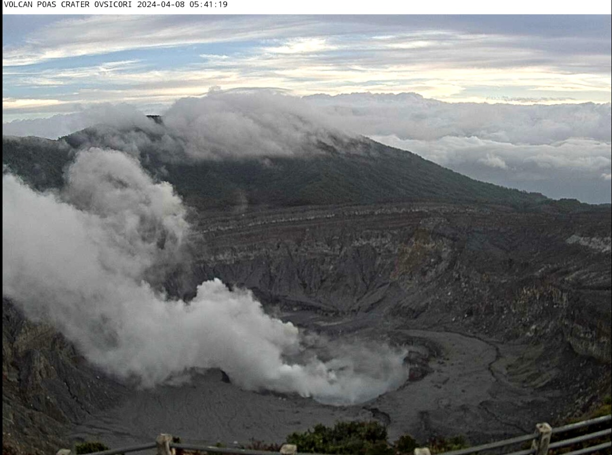
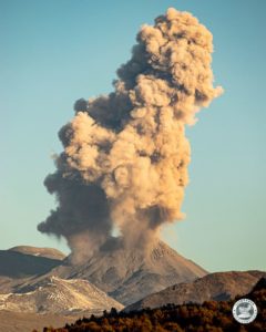
San José, April 8 (Prensa Latina) Active for several weeks, the Poás volcano in Costa Rica erupted again, this time with a plume of gas that reached 200 meters above its crater, reported today now the Observatory of Volcanology and Seismology (Ovsicori).
The eruption contains water vapor and volcanic gases, which also caused thick volcanic fog that affected several areas of the Greater Metropolitan Area. The wind pushes the ashes towards three western cantons, underlined the entity attached to the National University.
The fall of ash and the presence of gases, particularly sulfur dioxide, are causing concern among the population near the volcano.
The entrance to the park was closed until today, however we are awaiting the assessment of the authorities to determine its opening.
Last week, the National Emergency Commission (CNE) declared a green alert in six cantons in the province of Alajuela, affected by falling ash and a strong smell of sulfur.
The volcano remains classified at an alert level in which there are possible manifestations such as: small eruptions, bubbles, geysers, significant emission of acid gases, increase in temperature (incandescence) and seismic swarms/volcanic tremor, inflation-extension of the volcanic edifice.
Sources : Ovsicori , Prensa Latina
Photo : Ovsicori
New Zealand , Ruapehu :
Unusual style of earthquake activity continues at Mt Ruapehu, no changes in overall volcanic activity. The Volcanic Alert Level remains at 1.
Published: Tue Apr 9 2024 11:30 AM
Although the unusual earthquakes have continued under Mt Ruapehu, our other monitored parameters have not changed. We continue to measure low-moderate volcanic gas emissions, a slow decline in lake temperature and water level. The last gas flight, Crater Lake water and gas analysis, and visual observations show no changes. A sudden eruption at Mt Ruapehu remains very unlikely. The Volcanic Alert Level remains at 1 and the Aviation Colour Code at Green.
The uncommon style of small earthquakes recorded at shallow (1-2 km) depths under Mt Ruapehu and reported in our last bulletin, continue to occur. The number of earthquakes per day has decreased from the high seen in late March, and they remain small and difficult to identify, with only the larger events detected by our automatic systems. Over the last month, we have seen up to eight of these earthquakes a day, while now they amount to 0-6 per day.
As the earthquakes do not typically last more than 10 minutes, they do not categorise as volcanic tremor, which remains low at Ruapehu. The earthquakes are also quite different in appearance from volcanic tremor traditionally seen at Ruapehu.
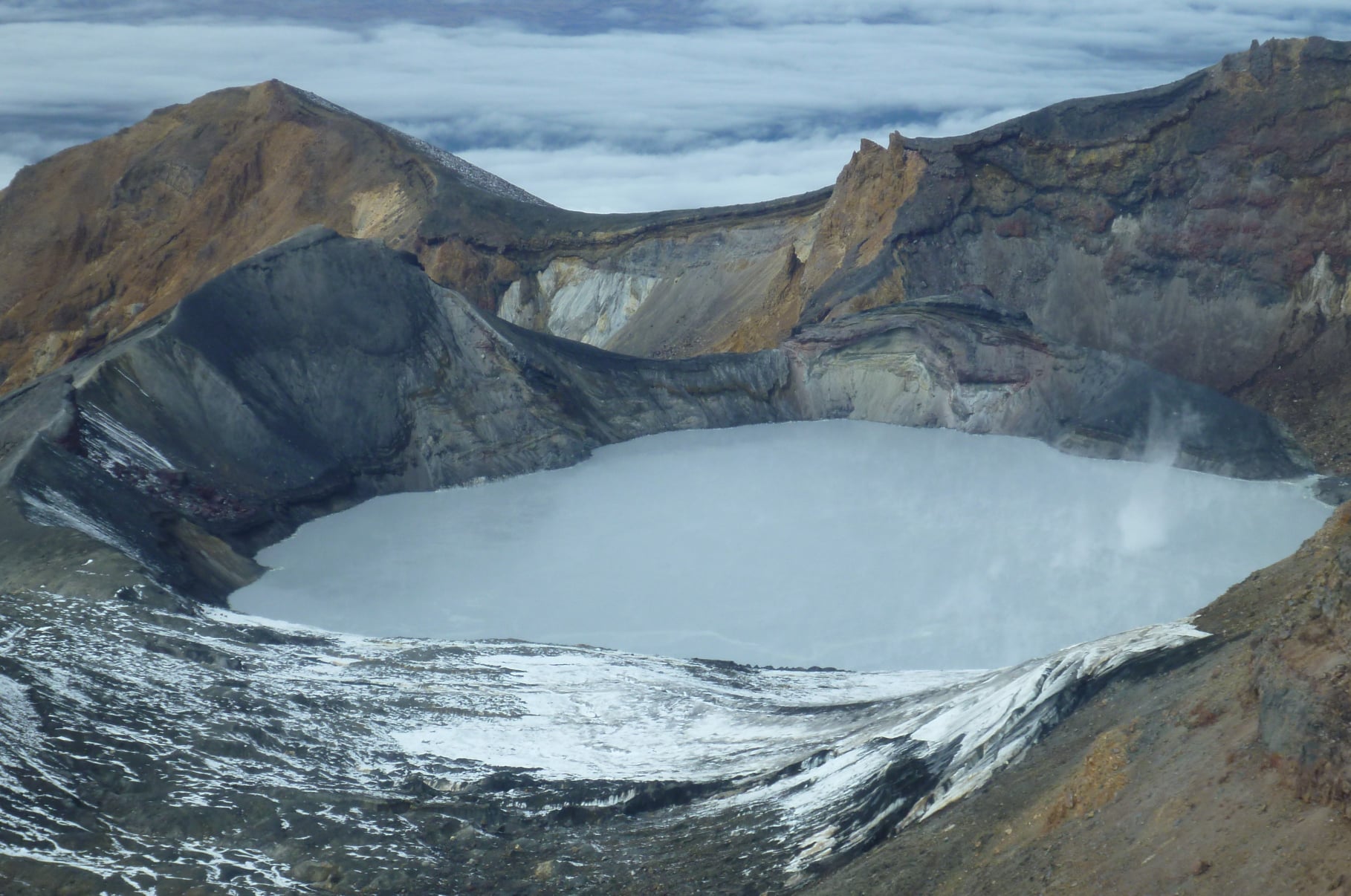
Te Wai ā-moe (Crater Lake) temperature continues a slow decline. Currently the lake temperature is 22 ºC, down from a peak of 31 ºC on February 14. The lake water level is also slowly declining, likely reflecting less melt water as air temperatures fall. The interpretation of gas and water samples from the lake show data consistent with cooling of the hydrothermal system formed by the lake and minor heating of the deeper system. The DOAS gas detection network has seen gas output increase slightly but remains in the low-moderate range for Mt Ruapehu.
In summary, earthquake activity beneath Ruapehu remains slightly higher than usual. This is influenced by the occurrence of the unusual events – noting these have decreased in number per day. Volcanic tremor levels remain low. The laboratory results from the gas samples indicate heating processes in the deeper parts of the system, and cooling within the shallow part, these being typical of the Ruapehu system. Our conceptual model has partial sealing occurring in the hydrothermal system beneath the crater lake, which in turn modulates the flow of gas and heat to shallower levels. Fracturing of the sealed area can be reflected as earthquakes and/or volcanic tremor. We are seeing low-moderate gas volumes passing through the lake presently, indicating paths are open.
Changes to the lake colour may occur if more/less disturbed sediment is suspended in the lake, leading to a change in the tone of the grey colour. The size and shape of the upwelling areas may also change. All of this is consistent with ongoing volcanic and hydrothermal processes and the overall low level of volcanic activity at Mt Ruapehu. A sudden eruption at Mt Ruapehu remains very unlikely.
Monitoring indicators remain consistent with a low level of volcanic activity. As a result, the Volcanic Alert Level remains at 1. The Aviation Colour Code remains Green.
Source : Geonet / Brad Scott / Duty Volcanologist
Photo : Geonet
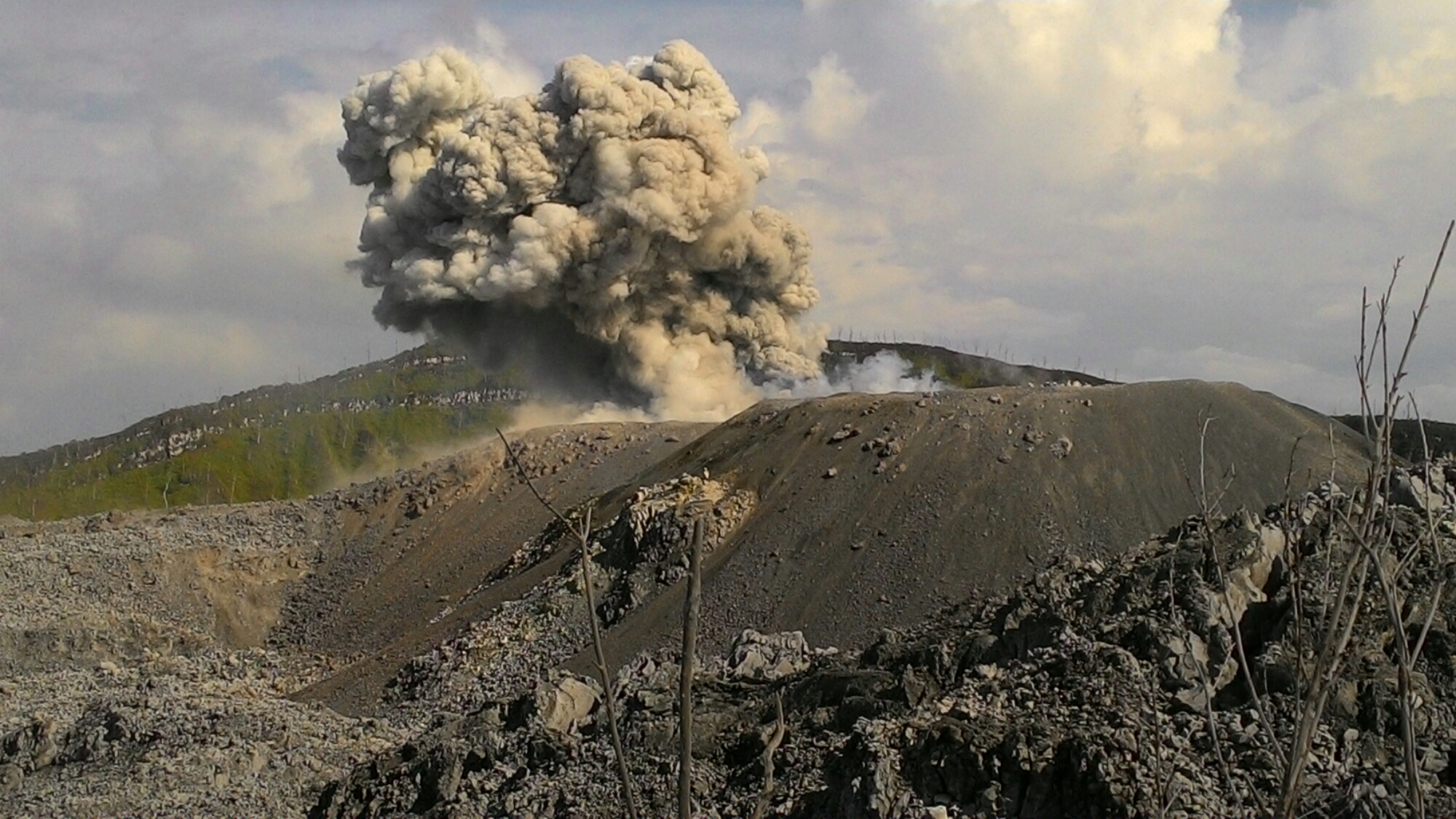
Indonesia , Ibu :
An eruption of Mount Ibu occurred on Tuesday, April 9, 2024 at 00:51 WIT with the height of the ash column observed at ±1,200 m above the summit (±2,525 m above sea level) . The ash column was observed to be gray in color with thick intensity, oriented towards the South-West. This eruption was recorded on a seismograph with a maximum amplitude of 28 mm and a duration of 120 seconds.
Observation of seismicity:
10 eruption earthquakes with an amplitude of 11 to 28 mm and a duration of 23 to 79 seconds.
74 emission earthquakes with an amplitude of 2 to 14 mm and earthquake duration of 15 to 50 seconds.
8 harmonic tremors with an amplitude of 2 to 10 mm and an earthquake duration of 74 to 495 seconds.
1 Tornillo type earthquake with an amplitude of 5 mm and an earthquake duration of 72 seconds.
404 Shallow volcanic earthquakes with an amplitude of 2 to 20 mm and an earthquake duration of 4 to 14 seconds.
4 deep volcanic earthquakes with an amplitude of 3 to 6 mm, earthquake duration of 5 to 8 seconds.
22 deep tectonic earthquakes with an amplitude of 2 to 28 mm, and the duration of the earthquake was 35 to 157 seconds.
RECOMMENDATION
1. Communities around Mount Ibu and visitors/tourists should not practice activities within a radius of 2.0 km and the sectoral extension of 3.5 km towards the opening of the crater in the northern part of the crater active Mount Ibu.
2. In the event of falling ash, people who carry out activities outside the home are advised to wear nasal, oral (mask) and eye (glasses) protection.
Source : Magma Indonésie .
Photo : John Massolo – WordPress.com ( Archive).
Guatemala , Santiaguito :
Weather conditions: Clear weather
Wind: North-East
Precipitation: 0.0 mm.
Activity:
The Santiaguito volcano observatory OVSAN reports moderate degassing on the crater which disperses towards the South-West. Weak to moderate explosions are recorded, expelling columns of gas and ash which disperse in a west and southwest direction. At night and early morning, constant incandescence was observed in the Caliente Dome crater and in the upper part of the lava flow in a West-Southwest direction.
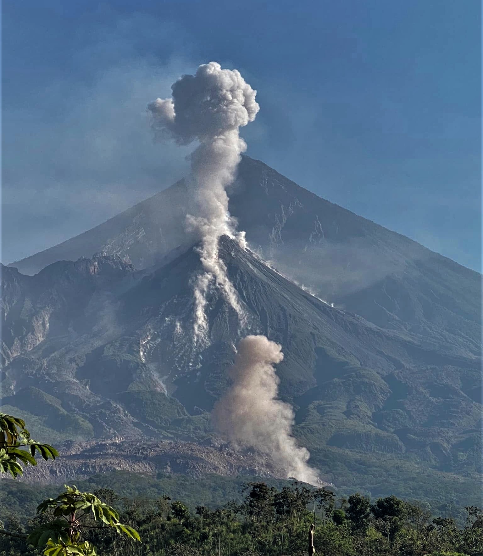
Constant avalanches of blocks, weak, moderate and some strong, are recorded on the lava flow, on the South flank and on the South-East flank. The volcano maintains high activity due to the extrusion of blocky lava into the Caliente dome in a west, southwest direction and the unstable nature of the material in the crater. There is a chance of moderate to strong pyroclastic flows, so do not stay near or in river beds near the slopes of the volcano.
Source : Insivumeh.
Photo : Armando Pineda