April 8 , 2024.
Italy / Sicily , Etna :
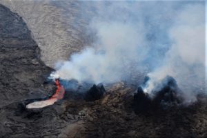
VOLCANIC ACTIVITY REPORT April 7, 2024, 1:10:36 PM (UTC) – ETNA.
The National Institute of Geophysics and Volcanology, Osservatorio Etneo, reports a strong emission of ash from the summit craters, visible by the summit crater cameras.
Press release on the activity of Etna, April 7, 2024 3:52 p.m. (1:52 p.m. UTC)
The National Institute of Geophysics and Volcanology, Osservatorio Etneo, communicates, based on the analysis of INGV-OE surveillance cameras, that a strong emission of ash from the Bocca Nuova crater was observed. This emission lasted about 4 minutes and reached an altitude of 5 km above sea level, quickly dispersing in the atmosphere towards the South. Seismically, a sequence of approximately 6 summit explosive events was recorded from 1:01 p.m. to 1:10 p.m. UTC, the most energetic of which was recorded at 1:10 p.m. UTC.
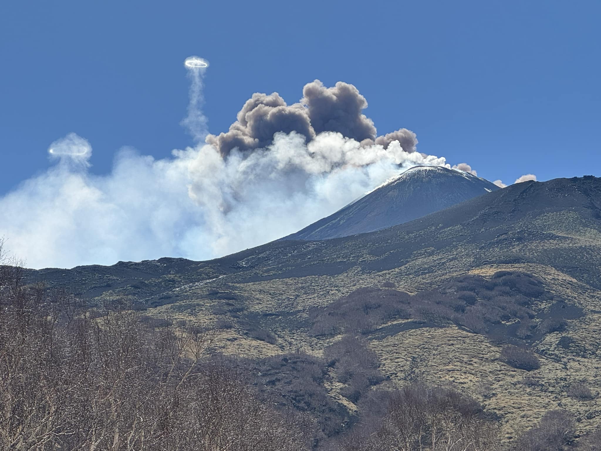
The average amplitude of volcanic tremors remains at the current state, although with some slight fluctuations, at the average level. The sources of the tremor are located under the Southeast crater, at an altitude of approximately 2,900 m above mean sea level. The infrasound signals are exclusively located at the Southeast crater. Finally, the analysis of the inclinometer signals does not reveal significant deformations.
Further updates will be communicated shortly.
Source : INGV
Photo : Fabrizio Zuccarello.
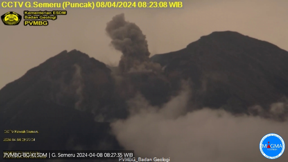
Indonesia , Semeru :
Mount Semeru exhibited an eruption on Monday, April 8, 2024 at 08:23 WIB with the height of the ash column observed at ± 500 m above the summit (± 4176 m above sea level). The ash column was observed to be white to gray in color with moderate intensity, oriented towards the South. At the time of writing, the eruption was still ongoing.
Observation of seismicity
9 eruption/explosion earthquakes with an amplitude of 11 to 22 mm and duration of the earthquake from 75 to 95 seconds.
4 emission earthquakes with an amplitude of 2 to 6 mm and duration of the earthquake from 41 to 66 seconds.
1 harmonic tremor with an amplitude of 6 mm, and an earthquake duration of 147 seconds.
RECOMMENDATION
1. Do not carry out any activities in the South-East sector along Besuk Kobokan, 13 km from the summit (center of the eruption). Apart from this distance, people do not carry out activities within 500 meters of the river bank (river boundary) along Besuk Kobokan as they may be affected by the expansion of warm clouds and lahar flows up to a distance of 17 km from the summit.
2. Do not practice activities within a 5 km radius around the crater/summit of the Mount Semeru volcano as it is subject to the risk of stone projection (spray).
Source et photo : Magma Indonésie.
Colombia , Cumbal :
Weekly activity bulletin: Cumbal Volcanic Complex
Regarding the monitoring of the activity of the CUMBAL VOLCANIC COMPLEX (CVC), the MINISTRY OF MINES AND ENERGY, through the COLOMBIAN GEOLOGICAL SERVICE (SGC), reports that:
Between March 26 and April 1, 2024, and compared to what was reported the previous week, seismic activity presented a slight decrease in its occurrence and the energy released.
The predominance of earthquakes related to rock fracture remained, scatteredly located in the volcanic region, at distances less than 16 km, with depths between 1.0 and 7.0 km from its summit (4,700 m above sea level) and magnitudes less than 1.6.
Gas emissions were recorded in the El Verde fumarole fields, northeast of the CVC; and Los Rastrojos and Boca Vieja, southwest of the CVC, with white columns, of variable dispersion direction and height depending on the wind direction. No significant variation was observed in the other geophysical and geochemical parameters of volcanic monitoring.
Volcanic activity remains in a YELLOW ALERT state: Active volcano with changes in the behavior of the base level of monitored parameters and other manifestations.
Source et photo : SGC
Ecuador , Reventador :
DAILY REPORT ON THE STATE OF THE REVENTADOR VOLCANO, Sunday April 7, 2024.
Information Geophysical Institute – EPN.
Surface activity level: Moderate, Surface trend: No changes
Internal activity level: Moderate, Internal trend: No changes
Seismicity: From April 6, 2024, 11:00 a.m. to April 7, 2024, 11:00 a.m.:
The following table shows the number of seismic events from the reference station in the last 24 hours.
Explosion (EXP) 58
Long Period (LP) 5
Transmitting tremor (TREMI) 4
Tremor harmonic (TRARM): 3
Precipitation/Lahars:
No rain was recorded in the volcano area. **Heavy rains could remobilize accumulated material and generate mud and debris flows that travel down the volcano’s flanks and flow into rivers downstream.
Emissions/ash column:
Due to weather conditions, gas and ash emissions could not be observed via surveillance cameras. The VAAC agency in Washington has not published reports relating to the activity of the volcano.
Observation:
Since yesterday, we have seen that the volcano has remained cloudy most of the time. Furthermore, during the night and early morning today, several episodes of descent of incandescent material were recorded which reached 800 meters below the level of the crater. Currently, the volcano remains cloudy
Alert level: Orange.
Source : IGEPN.
Photo : Henry Vasconez
Alaska , Atka :
Minor unrest at the Atka volcanic complex continues and a few small earthquakes were detected over the past day. Nothing was observed in cloudy satellite and webcam views of the volcano over the past day.
AVO has detected no unusual surface activity since a small explosion at the summit of Korovin volcano on the evening of March 27.
Korovin is one of the volcanoes that makes up the Atka volcanic complex.
The Atka volcanic complex is monitored by local seismic and infrasound sensors and webcam, satellite data, and regional lightning detection instruments.
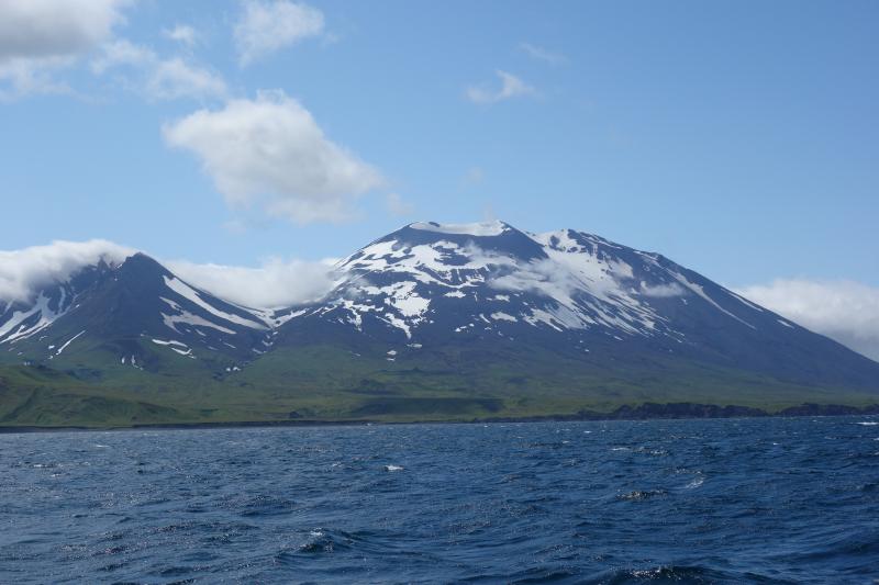
The Atka Volcanic Complex consists of a central shield and Pleistocene caldera with several post-caldera volcanoes. A major dacitic explosive eruption accompanied formation of the caldera about 500,000 to 300,000 years ago. The most prominent of the post-caldera stratovolcanoes are Kliuchef and Sarichef, both of which may have been active in historical time. Sarichef has a symmetrical profile, but the less eroded Kliuchef is the source of most if not all historical eruptions. Kliuchef may have been active on occasion simultaneously with Korovin volcano to the north. Hot springs and fumaroles are located on the flanks of Mount Kliuchef and in a glacial valley SW of Kliuchef. Korovin, at the NE tip of Atka Island, is the most frequently active volcano of the complex, and contains a double summit with two craters. The NW summit has a small crater, but the 1-km-wide crater of the SE cone has an open cylindrical vent of widely variable depth that sometimes contains a crater lake or a high magma column. A fresh-looking cinder cone lies on the flank of the partially dissected Konia volcano, located on the SE flank of the dominantly basaltic Korovin. Some late-stage dacitic lava flows are present on both Korovin and Konia.
Source : AVO , GVP
Photo : Schaefer, Janet / Alaska Volcano Observatory / Alaska Division of Geological & Geophysical Surveys