March 18 , 2022.
Hawaii , Kilauea :
19°25’16 » N 155°17’13 » W,
Summit Elevation 4091 ft (1247 m)
Current Volcano Alert Level: WATCH
Current Aviation Color Code: ORANGE
Activity Summary:
The summit eruption of Kīlauea Volcano, within Halemaʻumaʻu crater, continued over the past 24 hours. All recent activity has been confined to the vicinity of smaller active lake within the crater, and there are no indications of activity migrating elsewhere on Kīlauea. Activity was greatly diminished yesterday, with occasional injection of new lava at the surface. Tiltmeters recorded summit inflation starting around 11 pm last night, and activity resumed within the active lava lake area this morning around 2:20 am.
Halemaʻumaʻu Lava Lake Observations:
Eruption of lava from the western vent into the active lava lake surface (approximately 2.5% of Halemaʻumaʻu crater floor) was greatly diminished from yesterday morning through to around 2:20 am this morning, at which point rigorous lava effusion resumed. For much of yesterday, the active western lava lake surface of Halema‘uma‘u crater was lower than much of the last week, with occasional injections of new lava at the surface. From 2:20 am this morning the active lake level began to rise as activity resumed. Around 7 am this morning a lava flow originating from the embayment north of the western vent area started advancing northwest onto the crater floor. The highest point on the Halemaʻumaʻu crater floor has risen approximately 97 meters (318 feet) since the eruption began on September 29, 2021.
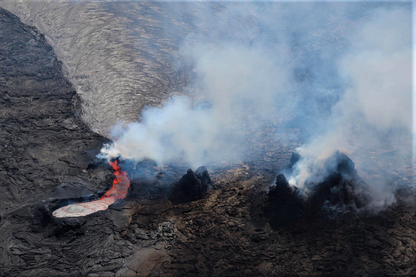
Telephoto view, looking east, of the lava source area for the active lava lake within Halema‘uma‘u at the summit of Kīlauea on March 11. The is supplied from the embayment which is just north (left) of the remnants of west cone area (center and right). From there, lava flows through a narrow spillway and then pours into the active lava lake, which has a silvery grey appearance. Over the past few weeks, the west vent cone area has broken down and lava has infilled between its craggy remnants. The tallest remnant to the south (right) rises 27 meters (89 feet) above the crater floor.
Summit Observations:
Summit tilt was flat yesterday, with inflation beginning around 11 pm last night, levelling off by 6 am this morning. Seismic data shows that the volcanic tremor was relatively low yesterday, and started increasing around 4:20 am this morning; current tremor has stabilized at a higher level than yesterday. Earthquake activity at the summit remains below background levels. A sulfur dioxide (SO2) emission rate of approximately 1900 tonnes per day (t/d) was measured on March 10.
Source : HVO.
Photo : USGS / N. Deligne.
Alaska , Semisopochnoi :
51°55’44 » N 179°35’52 » E,
Summit Elevation 2625 ft (800 m)
Current Volcano Alert Level: WATCH
Current Aviation Color Code: ORANGE
Seismic tremor and occasional small explosions were detected in seismic and local infrasound data over the past day. Clear webcam images showed low-level ash emissions from the north crater of Mount Cerberus. No ash from these explosions was observed in partly cloudy satellite images, however, possible sulfur dioxide gas emissions were detected.
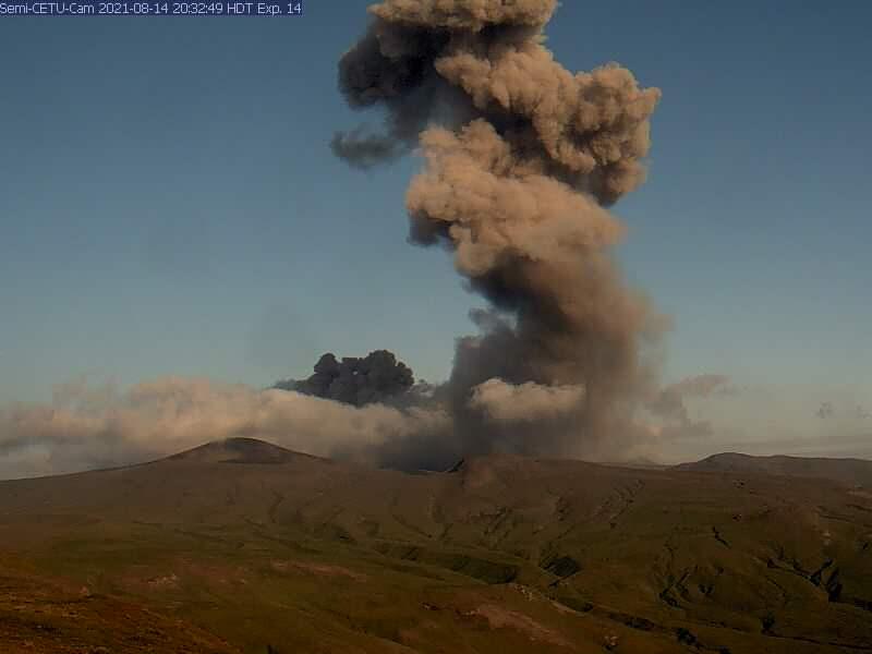
Small eruptions producing minor ash deposits within the vicinity of the active north crater of Mount Cerberus and ash clouds usually under 10,000 ft (3 km) above sea level have characterized the recent activity. Small explosions and associated ash emissions may continue and could be difficult to detect, especially when thick cloud cover obscures the volcano.
Semisopochnoi is monitored by local seismic and infrasound sensors, satellite data, web cameras, and remote infrasound and lightning networks.
Source : AVO.
Photo : AVO/USGS. (archive).
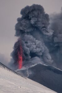
Indonesia , Semeru :
VOLCANO OBSERVATORY NOTICE FOR AVIATION – VONA
Issued : March 17 , 2022
Volcano : Semeru (263300)
Current Aviation Colour Code : ORANGE
Previous Aviation Colour Code : orange
Source : Semeru Volcano Observatory
Notice Number : 2022SMR65
Volcano Location : S 08 deg 06 min 29 sec E 112 deg 55 min 12 sec
Area : East java, Indonesia
Summit Elevation : 11763 FT (3676 M)
Volcanic Activity Summary :
Eruption with volcanic ash cloud at 23h15 UTC (06h15 local). Eruption and ash emission is continuing
Volcanic Cloud Height :
Best estimate of ash-cloud top is around 12403 FT (3876 M) above sea level, may be higher than what can be observed clearly. Source of height data: ground observer.
Other Volcanic Cloud Information :
Ash-cloud moving to west.
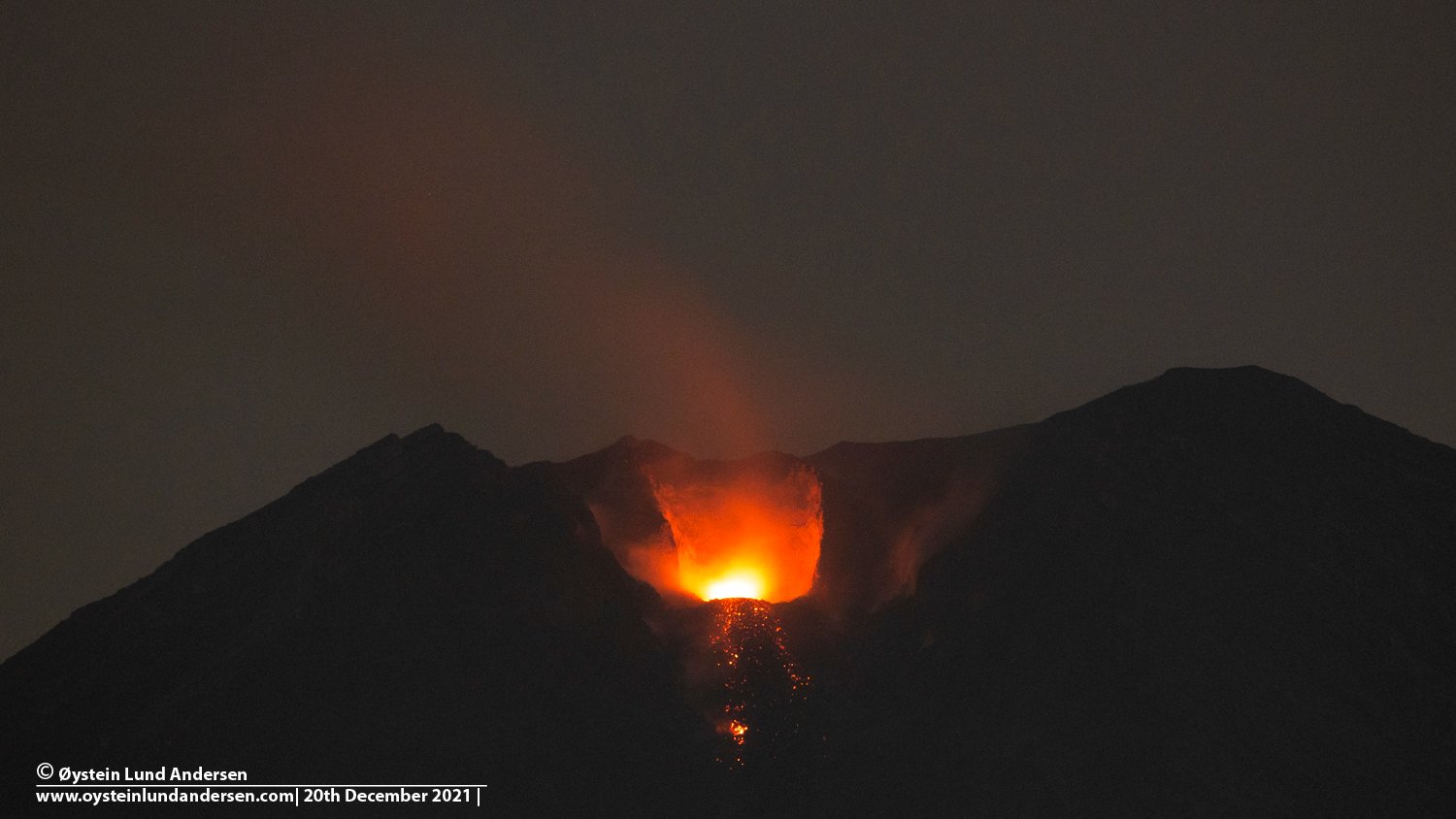
The volcano was clearly visible until it was covered in fog. Smoke from the crater was not observed. The weather is sunny to rainy, the wind is light to moderate in the North and West. The air temperature is around 21-30°C. An eruption was observed at a height of about 700 meters facing southwest.
Earthquakes are related to magma and tectonic activity. It was recorded:
– 63 earthquakes of eruptions/explosions
– 5 emissions earthquake
– 2 harmonic tremors
– 2 deep volcanic earthquakes
Sources : Magma Indonésie , PVMBG.
Photo : Oystein Lund Andersen .
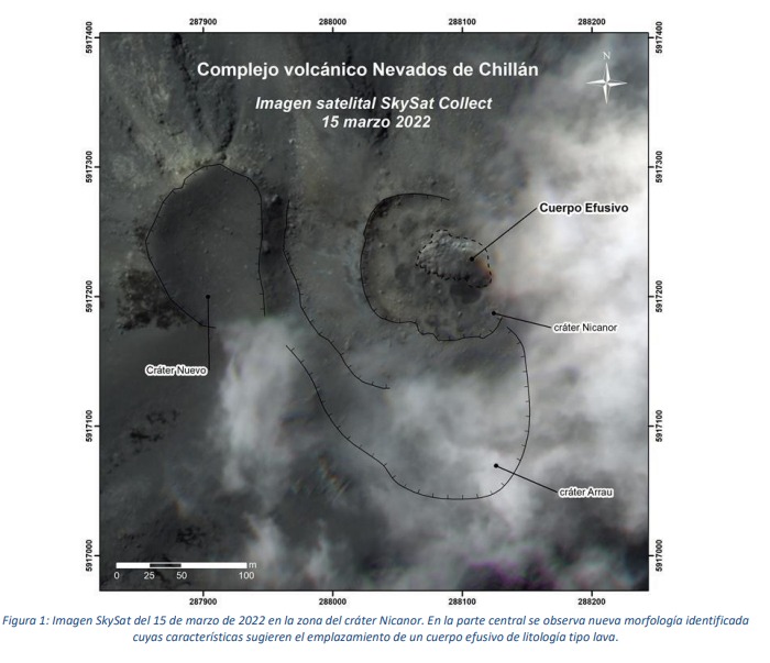
Chile , Nevados de Chillan :
Special Report on Volcanic Activity (REAV) Ñuble Region, Nevados de Chillán Volcanic Complex March 17, 2022, 7:30 p.m. local time (mainland Chile).
The National Geology and Mining Service of Chile (SERNAGEOMIN) announces the following information obtained through the monitoring equipment of the National Volcanic Monitoring Network (RNVV), processed and analyzed at the Volcanological Observatory of the Southern Andes (OVDAS) :
The eruptive cycle of the Nevados de Chillán volcanic complex (CVNCh) continues to evolve regularly and with some significant changes concerning, fundamentally, the extrusion of an effusive body inside the active crater.
Since March 1, 2022, the appearance of an effusive body nestled in the Nicanor crater has been observed from Planet satellite images, which coincides with the thermal radiation at the crater identified in Sentinel 2 L2A images. Thanks to the photo-interpretation of a very high resolution SkySat type satellite image dated March 15, 2022, the extrusion of the effusive body in the Nicanor crater is confirmed, which has a surface texture attributable to a lava-like lithology. It has an ellipsoidal shape, elongated in an East-West direction and irregular edges, with dimensions of 57 m in the major axis and 33 m in the minor axis, which covers an area of 1,665 m2 (Figure 1). The evolution of this new morphology in the next few days will allow more complete interpretations of its dynamics.
In terms of surface activity, the appearance of this new morphology is contemporaneous with a period of weak nocturnal incandescence and moderate explosive activity, whose eruptive columns are dominated by water vapor with occasional pyroclastic content, and heights below 1,500 m above the crater.
Seismic activity, since the cessation of lava extrusions and previous domes, has remained at low levels, but occasional increases in energy have been linked to specific increases in explosive activity with the generation of pyroclastic flows , however, the overall trend since January from 2022 has seen a steady decline. After the last two energetic explosions observed (February 19 and 20), the energetic trend of fluid seismicity changed, showing a slight upward trend, which suggests changes in the surface volcanic system, possibly related to extrusion. of the new surface lava body.
Data provided by the GNSS monitoring network show that the vertical positions of all stations remain stable, after a deflation observed from January to around February 12, 2022, with maximum rates below -1 cm/month for FRSC and SHLA stations . Likewise, the control lines that cross the volcano continue to shorten, with maximum rates of -0.4 cm/month. On the other hand, all the inclinometers show variations of less than 5 microradians during the last two weeks.
Sulfur dioxide (SO2) emissions data obtained using Differential Absorption Optical Spectroscopy (DOAS) equipment showed an increase in outgassing compared to February, recording an average of 454 t/ d and a peak SO2 rate on March 13. , 2,348 t/d, a value considered abnormal for this volcanic complex. The observed averages over the reported period are above baseline, showing similarities to other extrusive processes.
Two thermal alerts have been recorded in the area associated with the volcanic complex over the past 15 days, with a maximum Volcanic Radiative Power (VRP) of 6 MW on March 14, associated with the crater area, a value considered low according to the data processed by MIROVA (http://www.mirovaweb.it/). It should be noted that in previous processes of extruding effusive bodies, a similar behavior was observed in terms of the power observed in the anomalies.
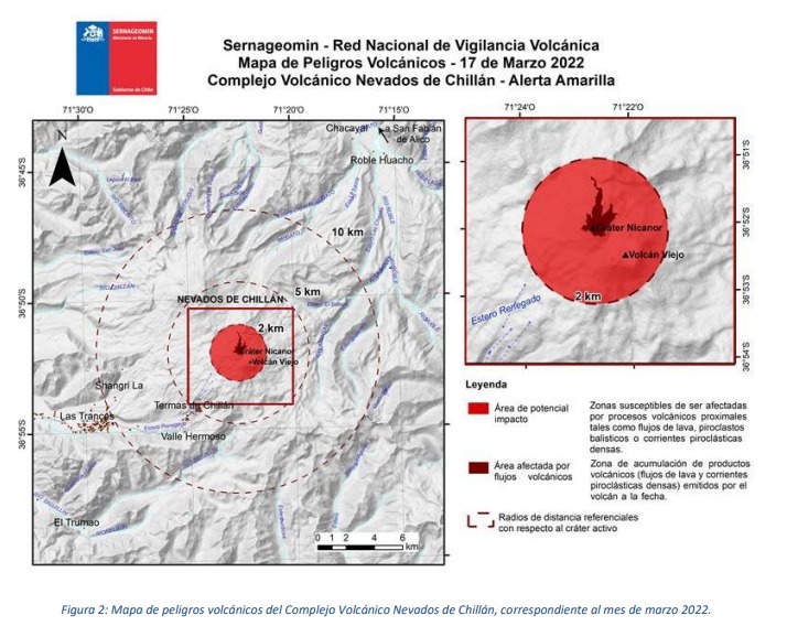
According to the exposed antecedents, the generation of a new effusive body inside the active crater is confirmed. However, according to the evolution of the monitoring parameters, it is expected that the explosive activity will present similar characteristics to what happened in the last period of the eruptive cycle, that is to say the appearance of sporadic eruptive columns at low altitude, dominated by steam, water and other volcanic gases, with variable contributions of pyroclastic material. Therefore, the zone likely to be affected by volcanic processes such as lava flows, dense pyroclastic currents and ballistic projections of pyroclasts is maintained, consisting of a radius of 2 km around the crater (Figure 2).
The volcanic technical alert remains at the Yellow level.
Source : Sernageomin
Photos : Sernageomin
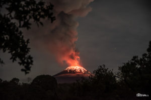
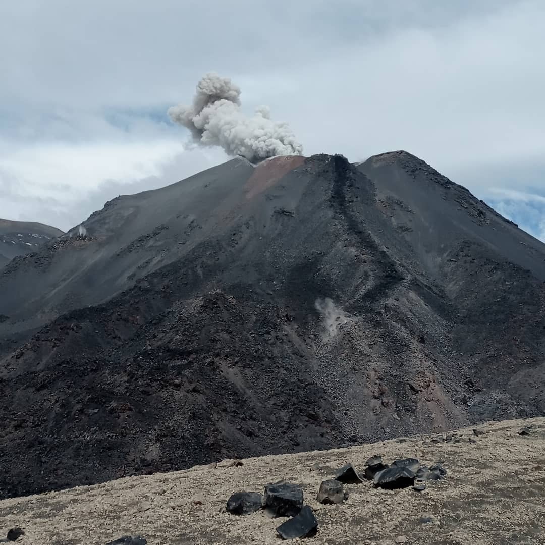
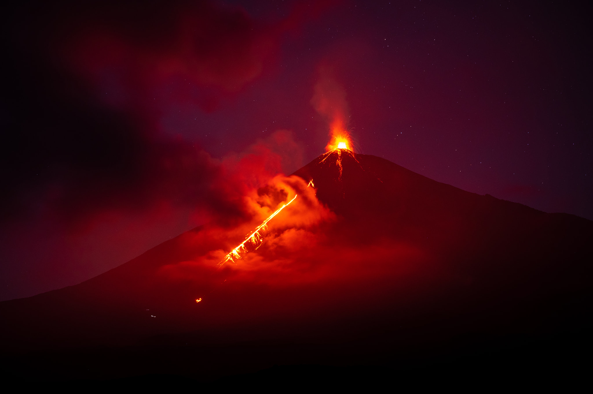
Guatemala , Fuego :
Atmospheric conditions: clear weather
Wind: northeast
Precipitation: 3.8 mm.
Activity:
It is recorded from 3 to 5 explosions per hour, with weak, moderate, strong characteristics. They expel ash from 4,500 to 5,000 m altitude (14,763 to 16,404 feet) which extends 15 to 20 km to the west, southwest and south. The explosive activity generates low to moderate rumblings with low to moderate shock waves that vibrate the roofs and windows of houses around the volcano. During the night and early in the morning, incandescent pulses are observed 100 to 200 meters above the crater. Due to the above, avalanches of weak, moderate to strong characteristics are generated. Fine ash falls are reported on the communities to the west and southwest of the volcano. The recommendations of the special bulletin BEFGO#015-2022 are still valid.
Source : Insivumeh.
Photo : Diego Rizzo .