February 24 , 2024.
Iceland , Reykjanes Peninsula :
Magma volume beneath Svartsengi reaching similar level as prior to last eruptions . Warning time could be very short or even none
Updated 23. February at 15:00 UTC
Model calculations indicate that approximately 5 million cubic meters of magma had recharged to the Svartsengi reservoir as of the 22 February. Considering the trend observed prior to previous volcanic eruptions in the Sundhnúkur crater row, the likelihood of an eruption is very high once the volume reaches between 8-13 million cubic meters (derived from joint InSAR-GNSS models). Based on the results of the model calculations, this could occur early next week if magma accumulation continues at the current rate.
It should be noted that there is a degree of uncertainty in this interpretation, and it cannot be assumed that the behaviour will be identical to the past eruptions here. Also, as the magma plumbing system evolves, we cannot rule out the possibility that the volume of magma required to trigger a new diking event and/or eruption may become reduced.
Additionally, there is a possibility that magma could migrate from that a dike intrusion occurs within this region without resulting in a volcanic eruption.
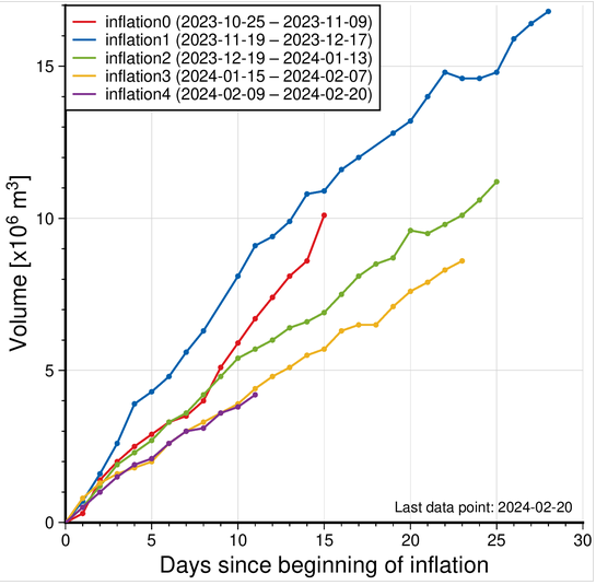
Figure: The graph displays a comparison of the volume of magma accumulated beneath Svartsengi before the magma flowed towards the Sundhnúkur crater row during the recent dike intrusions and eruptions that occurred between December 2023-February 2024. The volume is calculated by a model based on GNSS data and is subject to uncertainty. Significant variations can also be observed between consecutive days. The current magma accumulation status as of February 22 is marked by the purple line. The red line shows the amount of magma accumulated before the major diking event beneath Grindavík on November 10th.
If an eruption occurs, scientists estimate that magma will most likely propagate from the reservoir beneath Svartsengi towards Sundhnúkur crater row, resulting in lava fountaining and lava flows in the area between Stóra-Skógfell and Hagafell. The primary signal of ascending magma is a sudden increase in seismic activity with many localized, small magnitude earthquakes. Considering the previous volcanic eruptions in the area, an eruption could start with very little warning (less than 30 minutes), depending on where magma reaches the surface on the Sundhnúkur crater row.
Likely scenarios
Eruption between Sýlingarfell and Stóra-Skógfell – As occurred on December 18, 2023 and February 8, 2024.
Precursor: Sudden, localized, and intense seismic activity with small magnitude earthquakes. Deformation over the magma dike (if a dike is intruded) and the Svartsengi magma reservoir
Very short warning time (less than 30 minutes) because a new dike propagation may not be required for magma to reach the surface. -Lava reaches Grindavík road in less than 4 hours.
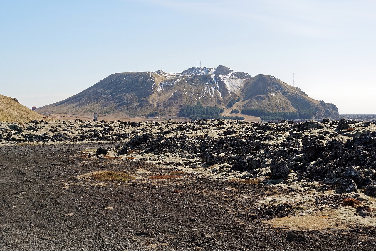
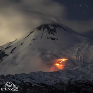
View from the north of Þorbjörn, the crater constituting the highest point of Svartsengi.
Eruption by Hagafell – As occurred on January 14, 2024.
Precursor: Seismic activity with small magnitude earthquakes on the Sundhnúkur crater row, starting near Sýlingarfell and migrating south. Deformation over the magma dike and the Svartsengi magma reservoir
Likely warning time is approximately 1-3 hours from the detection of the first earthquakes until the start of an eruption.
Lava reaches the lava barriers around Grindavík within 1 hour.
Magma intrusion, which reaches south of Hagafell, will likely cause significant fault movements in Grindavík
Eruption inside of the lava barriers around Grindavík
Seismic activity with small magnitude earthquakes on the Sundhnúkur crater row, starting near Sýlingarfell and migrating south. Deformation over the magma dike and the Svartsengi magma reservoir
Probable warning time is between approximately 1-5 hours from the detection of the first earthquakes until the start of an eruption.
It is possible that an eruptive fissure/s will open within Grindavík or the region just north of here (inside the barriers). Similar activity occurred on the 14th of January when a volcanic fissure opened just inside the outer perimeter of the town approximately 4 hours after an onset of the eruption near Hagafell.
Magma intrusion, which reaches south of Grindavík, will cause significant fault movements in Grindavík.
Although there is clear indication of uplift in the Svartsengi-Þórbjörn area (related to magma recharge of this reservoir) this does not mean that it is the most likely location for an eruption to start. This is because the magma reservoir is currently failing on its northeastern edge feeding dike propagations which are initiated between Stóra-Skógfell- and Sundhnúkur crater row. In a scenario where magma ascends towards the surface directly from the Svartsengi reservoir, it is estimated that the first signs of magma migration would be detected 4-7 hours before magma reaches the surface.
Please note that these scenarios are based on interpretations of the latest data and the observed development of the previous events at the Sundhnúkur crater row area. Uncertainty must be accounted for in this interpretation, as it is only based on few events.
Source : IMO
Photos : IMO , Jakub Hałun /wikipedia.
Russia / Kuril Islands , Ebeko :
50.69 N, 156.01 E;
Elevation 1156 m (3792 ft)
Aviation Colour Code is ORANGE
A moderate explosive eruption of the volcano continues. Ash explosions up to 6 km (19,700 ft) a.s.l. could occur at any time. Ongoing activity could affect low-flying aircraft and airport of Severo-Kurilsk.
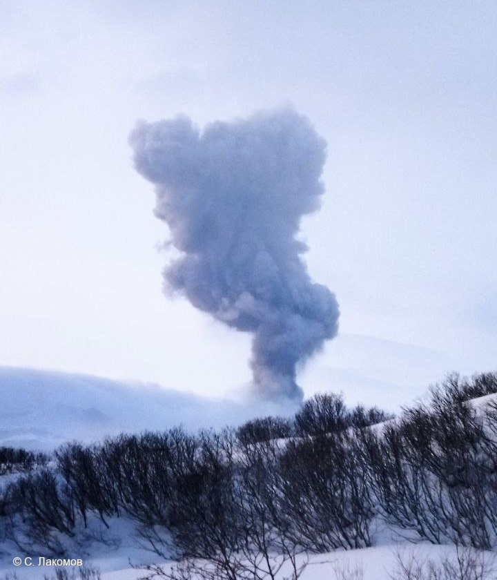
A moderate explosive eruption of the volcano continues. According to visual data from Severo-Kurilsk, explosions sent ash up to 2.5 km a.s.l. on 16 and 18-20 February; ash clouds drifted to the northwest and east of the volcano; ashfalls were observing at Severo-Kurilsk on 18 and 19 February. Satellite data by KVERT showed the volcano was quiet or obscured by clouds during the week.
Source : Kvert
Photo : S. Lakomov
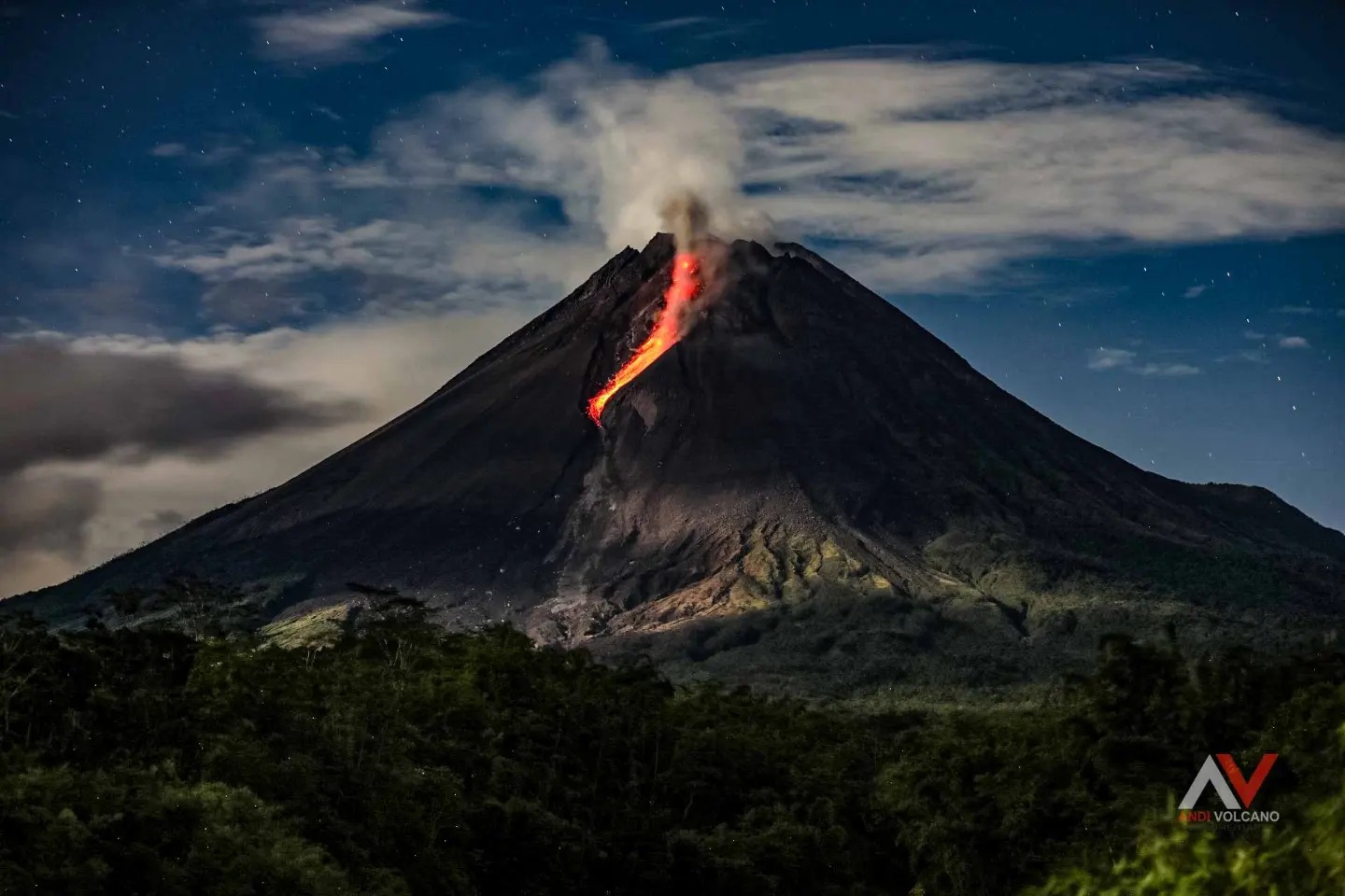
Indonesia , Merapi :
Mount Merapi activity report, February 16 to 22, 2024. Published on February 24, 2024
OBSERVATION RESULT
Visual
The weather around Mount Merapi is generally clear in the morning and night, while it is foggy from noon to evening. White, fine to thick smoke of low to moderate pressure and a height of 500 m was observed from the Mount Merapi Selo observation post on February 19, 2024 at 05:30 WIB.
This week, two warm cloud avalanches fell towards the southwest with an estimated maximum sliding distance of 1,600 m. Lava avalanches were observed 145 times in the South and South-West, including 3 times upstream of the Boyong River over a maximum distance of 1,000 m and 142 times upstream of the Bebeng River over a maximum distance of 1,700 mr. The sound of avalanches was heard 4 times from the Babadan and Jrakah posts with low to moderate intensity.
It was observed that the morphology of the southwest dome changed due to the activity of hot cloud avalanches and lava avalanches. The measured hot spot was 254.2°C, relatively the same as the previous measurement temperature. The morphology of the median dome is relatively constant. The measured hot spot was 191.3°C, which was lower than the previous measurement temperature. Based on the analysis of aerial photos from January 10, 2024, the volume of the southwest dome was measured at 2,663,300 m3 and that of the central dome at 2,358,400 m3.
Seismicity
This week the seismicity of Mount Merapi recorded:
2 warm cloud avalanche earthquakes (APG),
25 superficial volcanic earthquakes (VTB),
146 multi-phase (MP) earthquakes,
588 avalanche earthquake (RF),
15 tectonic earthquakes (TT).
The intensity of earthquakes this week is still quite high.
Deformation
The deformation of Mount Merapi monitored by EDM this week showed a shortening rate of 0.32 cm/day.
Rain and lahars
This week there was rain at Mount Merapi lookout post with a rain intensity of 49 mm/hour for 75 minutes at Jrakah lookout post on February 20, 2024. No additional flow or lahar was reported in the rivers that have their source on Mount Merapi.
Conclusion
Based on the results of visual and instrumental observations, it was concluded that:
Volcanic activity at Mount Merapi is still quite high in the form of effusive eruptive activity. The activity status is set to the “SIAGA” level.
Source : BPPTKG
Photo : Andi Volcanist.
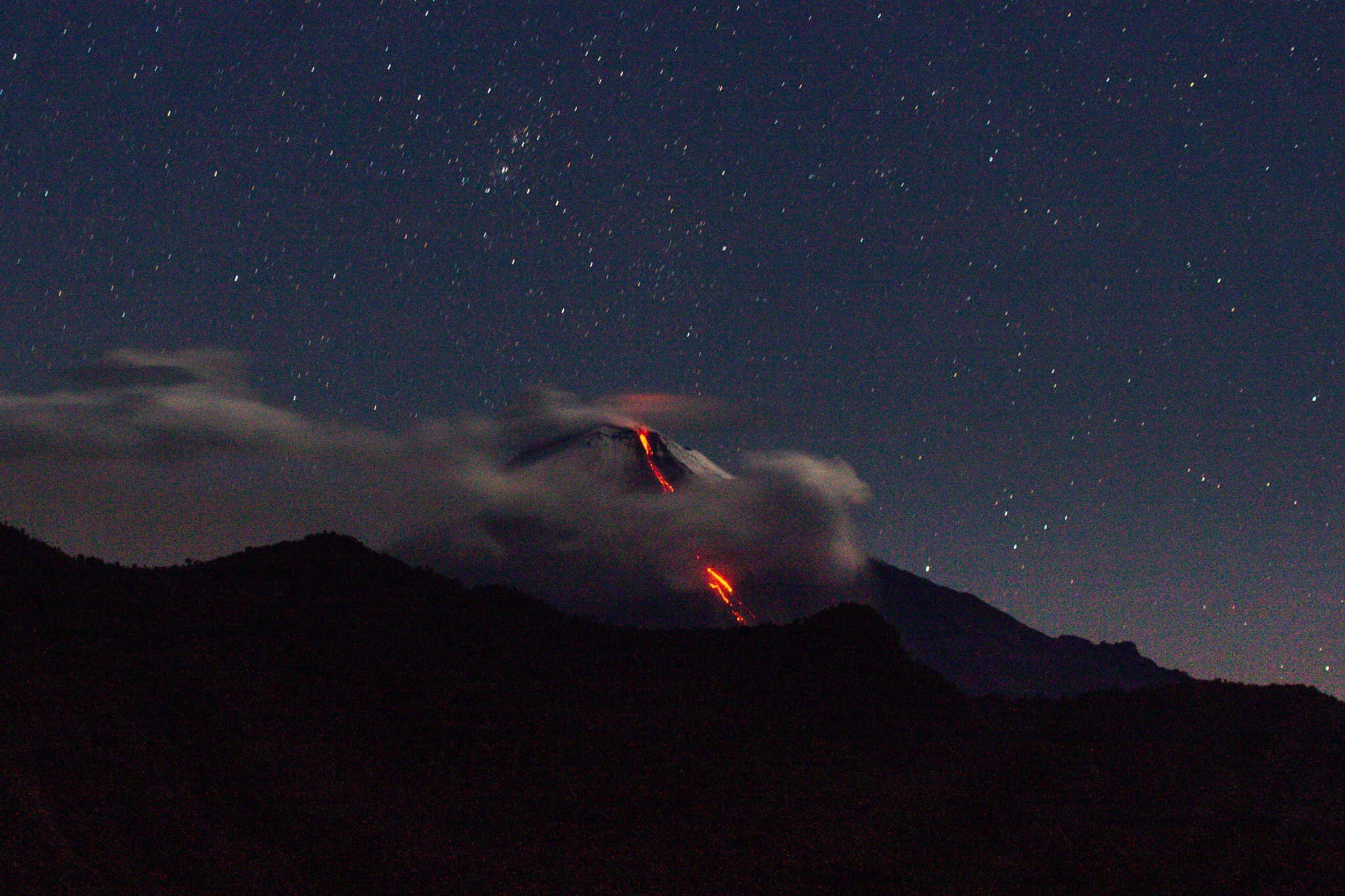
Ecuador , Sangay :
DAILY REPORT ON THE STATE OF THE SANGAY VOLCANO, Friday February 23, 2024.
Information Geophysical Institute – EPN.
Surface activity level: High, Surface trend: No change
Internal activity level: High, Internal trend: No change
Seismicity: From February 22, 2024, 11:00 a.m. to February 23, 2024, 11:00 a.m.:
The number of seismic events recorded at the reference station over the past 24 hours is shown below. The level of seismic activity of the volcano remains high.
Explosion Event (EXP): 210
Precipitation/Lahars:
Rains were recorded in the volcano area without generating mudslides or debris. *In the event of heavy rains, these could remobilize the accumulated materials, generating flows of mud and debris which would flow down the sides of the volcano and flow into adjacent rivers.
Emissions/ash column:
Due to weather conditions, it was not possible to observe gas and/or ash emissions through the surveillance camera network, nor through the GOES-16 satellite system. On the other hand, the VAAC agency in Washington has not published emissions reports in the last 24 hours.
Other monitoring parameters:
The FIRMS satellite system recorded 4 thermal anomalies, while MIROVA-VIIRS detected 1 thermal anomaly in the last 24 hours.
Observation:
Since yesterday afternoon until the submission of this report, the volcano has remained completely cloudy; However, yesterday evening, thanks to the surveillance camera system, incandescent materials were observed in the South-East ravine.
Alert level: yellow
Source : IGEPN.
Photo : TopMotor Storee.
Costa Rica , Poas :
Latitude: 10.20°N;
Longitude: 84.23°W;
Altitude: 2687 m above sea level.
Current activity level: Warning
Possible manifestations: Small eruptions, bubbling or geyser, significant gas emission, increase in temperature (incandescence), seismic swarms or volcanic tremor,
slight inflation-extension of the volcanic edifice.
The last eruption was recorded on February 8 at noon, since then the background tremor, although stable, has decreased in intensity, as has the number and amplitude of low-frequency seismic signals. Likewise, from February 8, the small eruptions and bubblings which had been frequently recorded from December 2023 to 2023 decreased in energy until disappearing over the weekend.
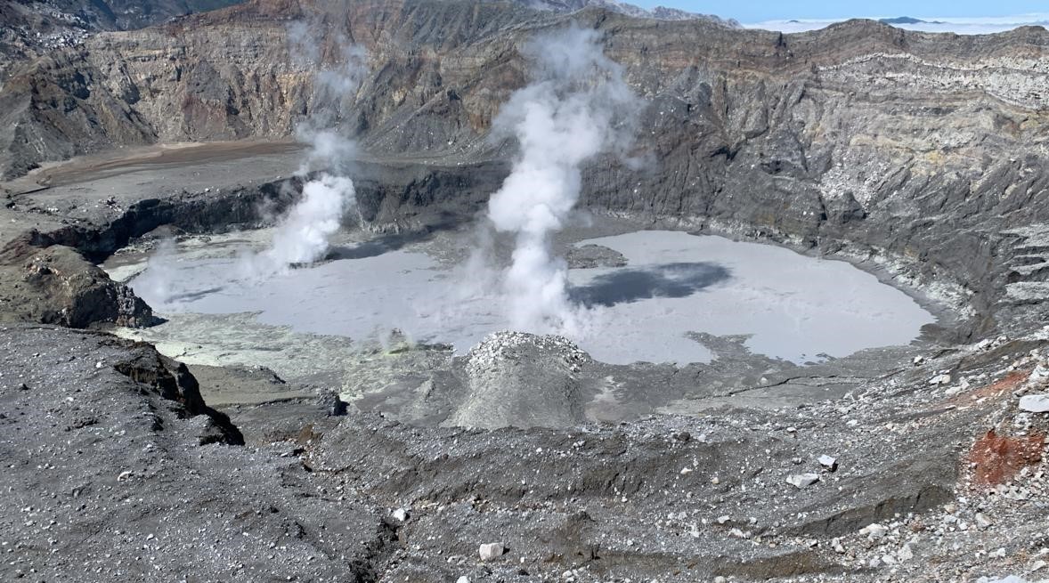
We observe low fumarolic activity and an increase in the level of the lagoon due to heavy precipitation in recent days.
Geodetic stations continue to show a contraction of the crater even if it seems to be decreasing in recent days. The SO2/CO2 ratio remains high, with a weekly average of 2.2 ± 0.7, with a slight downward trend in recent days. The H2S/SO2 ratio remains around 0.16. The SO2 concentration among visitors reached a maximum of 9.1 ppm this week, with a weekly average of 0.3 ppm. During the previous week, a SO2 flux of 243 ± 117 t/d was recorded, similar to that of three weeks ago (250 ± 118 t/d).
Source : Ovsicori
Photo : Maarten de Moor / Ovsicori.