October 19 , 2021.
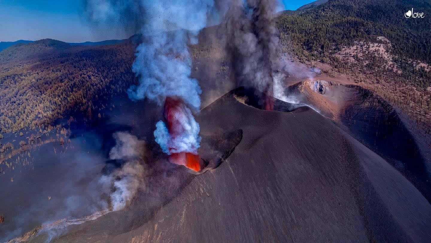
La Réunion , Piton de la Fournaise :
Press release of October 18, 2021 – 5:15 a.m.
Since 04:33 local time (00:33 UTC time) this morning, a seismic crisis has been recorded on the instruments of the Volcanological Observatory of Piton de la Fournaise. This seismic crisis is
accompanied by rapid deformation. This indicates that the magma is leaving the magma reservoir and is spreading towards the surface.
A rash is likely shortly within the next few minutes or hours.
Additional information will follow concerning the sector impacted by this magmatic propagation towards the surface.
Recommended alert level: Alert 1
Press release of October 18/2021 – 11:00 a.m.
The seismic crisis that began at 4:33 am local time (12:33 am UTC) continues. Between 04:33 and 10:50 local time, 537 volcano-tectonic earthquakes and 81 long-period type earthquakes were recorded by the OVPF. This seismicity is localized under the summit zone and under the eastern flank (between 0.6 km above sea level and 1.2 km below sea level; Figure 1).
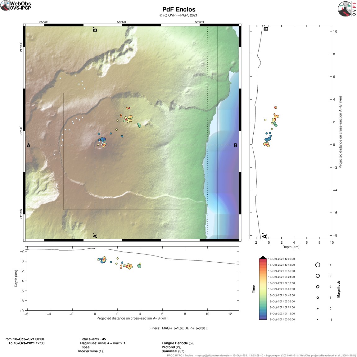
Figure 1: Location map (epicenters) and north-south and east-west sections (showing the location in depth, hypocenters) of the earthquakes recorded and located by the OVPF-IPGP on 10/18/2021 under the Piton de the furnace.
Only a few characteristic earthquakes have been located at this time (© OVPF-IPGP).
The seismicity and the source of the deformations show a migration of the magma in depth towards the north northeast flank of the volcano (Figure 1), in the Piton de Crac sector, a little further north than the intrusion of September 28-30. 2020. In 2020, the seismic crisis, which accompanied this intrusion, lasted two days and did not lead to an eruption, the magma having stopped in depth.
At present, the risk of eruptive fissure opening at low altitude is not excluded. In general at Piton de la Fournaise, the longer the seismic crises, the greater the risk of opening eruptive cracks at low altitude.
Alert level: Alert 1
Press release of October 18, 2021 – 4:15 p.m.
The seismic crisis that began at 4:33 am local time (12:33 am UTC) continues. Between 04:33 and 16:00 local time, 627 volcano-tectonic earthquakes and 176 long-period type earthquakes were recorded by the OVPF. This seismicity is located under the summit area and under the northeast flank (between 0.7 km above sea level and 1.4 km below sea level.

The seismicity and the source of the deformations show a migration of the magma in depth towards the north northeast flank of the volcano, in the northwest sector of the Piton de Crac, to the west of the Plaine des Osmondes.
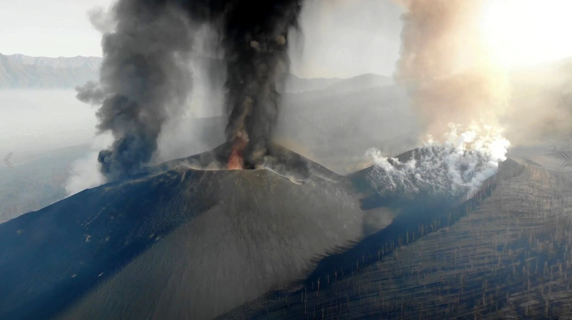
Press release of October 19, 2021 – 9:00 a.m.
The seismic crisis that began at 4:33 am local time (12:33 am UTC) gradually subsided this morning. This morning, only rare earthquakes are still recorded and their location remains
confined in the Plaine des Osmondes sector to the West – Northwest of Piton de Crac.
A total of 679 volcano-tectonic earthquakes, and 241 long-period and deep-type earthquakes were recorded by the OVPF between 10/18/2021 and 10/19/2021 8am local time. This seismicity was localized under the summit zone and under the northeast flank (between 0.7 km above sea level and 1.4 km below sea level;
Alert level: Alert 1
Source : OVPF. / Aline Peltier / Management of the Volcanological Observatory of Piton de la Fournaise.
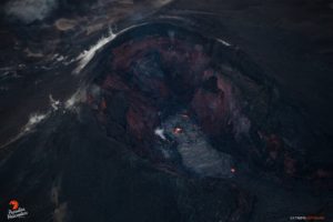
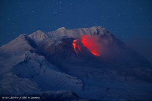
Photo : Imaz Press
Spain / La Palma , Cumbre Vieja :
October 17, 2021 09:00 UTC. Eruptive activity continues on La Palma.
Since the last declaration, 72 earthquakes have been located in the Sd part of the island of La Palma, near the current volcanic eruption.
The maximum magnitude recorded over this period is 4.3 (mbLg) corresponding to an earthquake that occurred at 03:10 UTC located 35 km deep under the central area of the island and which was felt by the population with a maximum intensity of IV (EMS).
The average amplitude of the volcanic tremor continues in a range of average values compared to the observations measured during this eruption, with some intensification pulses during the last hours, especially in the low frequency range (0.5-0 , 7Hz).

The height of the dispersion cloud measured at 08:00 UTC is estimated at 4,200 m.
The network of permanent GNSS stations on the island does not show a clear trend in the deformation of the stations closest to the eruptive centers after a reversal of that recorded in recent days in LP03.
Crucial hours for the population. The volcano of La Palma maintains its vigor in the last hours or currently predominates the emission of lava above the explosive phase, which produces pyroclastic deposits. This continuous flow of lava from the cone northwest of the volcanic cone continues to fuel the first lava flow that emerged on September 19. But, above all, it provides material for the two flows located further north, the two which most concern the volcanic emergency plan of the Canary Islands (Pevolca). The two who have shown the most activity over the past week.
The various flows of the La Palma volcano have entered a phase of « stability and slowness », even the one which until now has been more active and which is located about 160 meters from the sea. The director of the Geographical Institute National (IGN) of the Canary Islands, María José Blanco, indicated that due to the flow and speed, just two meters per hour, of this flow, which was the one that destroyed a supermarket in the district of La Laguna and which now crosses an area of banana trees, an imminent arrival at sea is not foreseeable.
Morcuende indicated that the other flow that threatens the center of La Laguna, whose population was evacuated last week, is about 200-250 meters away, but the direction it could take, because now it is practically » stopped « , would be towards the South-West and that it would end up joining the one which has advanced the farthest towards the sea. He also underlined that during the last hours » a net loss of power « of the flows lava has been appreciated, which instead of advancing increases in thickness.
18 October 2021 10:00 UTC Eruptive activity continues on La Palma
Since the last communication, 101 earthquakes have been located in the area affected by the volcanic reactivation of Cumbre Vieja, 7 of these earthquakes were felt by the population, the maximum intensity being in the epicentral zone IV (EMS98) , with the earthquakes that occurred at 11:06 am and 11:57 pm UTC on the 17th, with magnitudes of 4.0 and 4.6 (mbLg) at depths of 35 and 36 km, respectively. Moreover, this last earthquake was the most important of the period under consideration.
In total, 35 earthquakes were located at depths of about 30 km, the rest of the hypocenters of the period are located at a lesser depth, about 12 km.
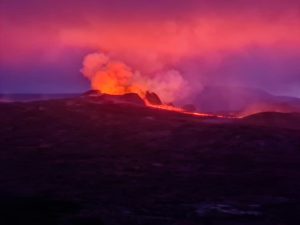
Crater of the Cumbre Vieja volcano, on the Canary Island of La Palma.
(GOVERNMENT OF THE CANARY ISLANDS)
The volcanic tremor signal maintains a high average amplitude, with intensifying pulses, since the last communication.
The height of the dispersion cloud measured at 08:00 UTC is estimated at 4000 m.
The network of permanent GNSS stations on the island does not show a clear trend in the deformation of the stations closest to the eruptive centers.
Source : IGN es , El Pais.
Carte : Copernicus.
Photos : I Love The World , GOVERNMENT OF THE CANARY ISLANDS
New Zealand , White Island :
Whakaari/White Island: Volcanic unrest continues, lower gas emission and steady active vent temperatures . Published: Mon Oct 18 2021 2:00 PM
Volcanic Alert Level remains at 2
Aviation Colour Code remains at Yellow
Recent gas and observation flights at Whakaari / White Island show lower gas emissions and low vent temperatures remain. The volcano still occasionally emits traces of volcanic ash and remains in a state of moderate to heightened unrest. The Volcanic Alert Level remains at Level 2.
Last week GNS scientists undertook a gas emission measurement flight and made visual observations and temperature measurements from a helicopter.
The gas measurements showed emissions of Sulphur Dioxide (SO2) have decreased to 267 tonnes per day from 520 tonnes per day at the end of September. The emissions in Carbon Dioxide (CO2) and Hydrogen Sulfur (H2S) also decreased to 757 and 10 tonnes per day, respectively.
Temperatures measured in the active vent area were similar in value to those measured 2 weeks ago, with a maximum 220 °C recorded.
The minor deposits from the intermittent volcanic ash emission described in previous bulletins were visible but were confined to the area close to the active vents.

Aerial view of the Main Crater at Whakaari/White Island showing the active vent and crater lakes. Taken Oct 2021
Weak ash emission was occurring during the observations made last week, and intermittent ash emission is still possible.
Seismic activity remains similar to last week, with low levels of volcanic tremor and occasional low-frequency volcanic earthquakes.
The current level of activity is consistent with moderate to heightened levels of unrest. As such the Volcanic Alert Level remains at 2 and the Aviation Colour Code remains at Yellow.
Equipment that provides real-time monitoring on the island is currently degraded and we are continuing to work on restoration options.
The Volcanic Alert Level reflects the current level of volcanic unrest or activity and is not a forecast of future activity. While Volcanic Alert Level 2 is mostly associated with volcanic unrest hazards (including discharge of steam and hot volcanic gases, earthquakes, landslides, and hydrothermal activity), potential for eruption hazards also exists and eruptions can still occur with little or no warning.
GNS Science and the National Geohazards Monitoring Centre continue to monitor Whakaari/White Island for further changes in unrest.
Source and photo : Geonet / Agnès Mazot / Duty Volcanologist
Peru , Sabancaya :
Analysis period: from October 11, 2021 to October 17, 2021, Arequipa, October 18, 2021.
Alert level: ORANGE
The Geophysical Institute of Peru (IGP) reports that the eruptive activity of the Sabancaya volcano remains at moderate levels, that is to say with the recording of an average of 34 daily explosions, with columns of ash and gas up to 3 km altitude above the summit of the volcano and their consequent dispersion. Therefore, for the following days, no significant change is expected in eruptive activity.
The IGP recorded and analyzed the occurrence of 611 earthquakes of volcanic origin, associated with the circulation of magmatic fluids within the Sabancaya volcano. An average of 34 explosions was recorded daily. During this period, Volcano-Tectonic (VT) earthquakes associated with rock fracturing were located mainly in the Northwest, Northeast and North of Sabancaya and presented magnitudes below M4 , 6.
The monitoring of the deformation of the volcanic structure using GNSS techniques (processed with fast orbits) does not show any significant anomalies. However, in general, an inflation process was observed in the northern sector (around the Hualca Hualca volcano). The visual surveillance made it possible to identify columns of gas and ash up to 3 km altitude above the summit of the volcano, which were scattered towards the South-West, South, South-East, North and North sectors – West of Sabancaya. Satellite recordings identified the presence of 6 thermal anomalies (maximum value of 9 MW) associated with the presence of a lava body on the surface of the volcano’s crater.
RECOMMENDATIONS
• Keep the volcanic alert level in orange.
• Do not approach within a radius of 12 km from the crater.
Source : IGP.
Photo : Ingemmet
Iceland , Fagradalsfjall :
The Civil protection crisis level lowered from orange to yellow for the Volcano in Fagradalsfjall
Aviation color code changed from orange to yellow

During the past month (18th September – 18th October) no lava flow from the crater has been detected at Fagradalsfjall volcano. Out gassing is still ongoing with very low concentrations of eruptive gases. Similarly, thermal anomalies continue to be detected at lower values and greater intervals between detection’s. Glow from previously emplaced lava moving is occasionally seen at night. Heat, gases and glow may continue for weeks/months even if no new lava is erupted. The seismic activity SW of Keilir which commenced on the 26th of September has significantly reduced in the past few days.
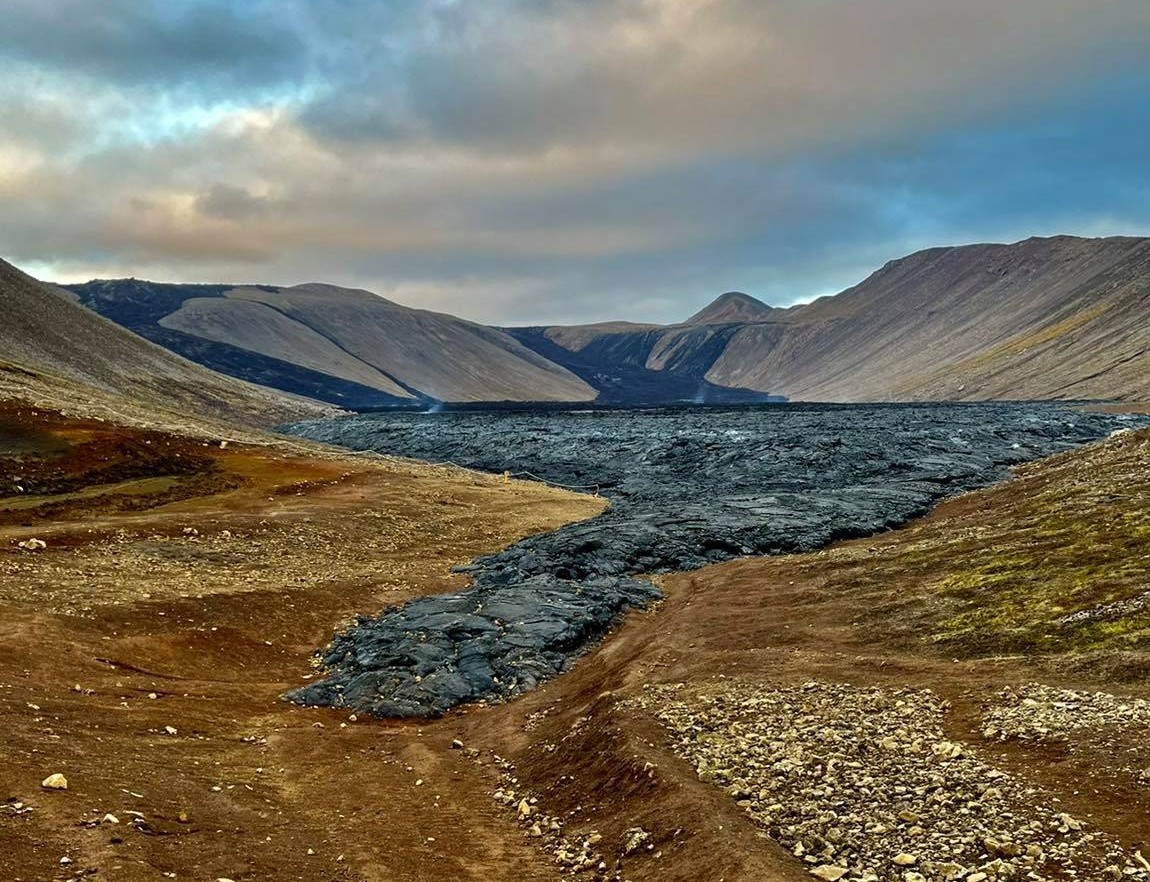
The Fagradalsfjall eruption will not be declared over until much later in the future, as the distinction between a break and a true ending is only apparent in retrospect. Activity might resume again in the near or distant future, either in the same place or at a new opening.
In light of the current observations and data available, it is assessed that Krýsuvík volcano is currently in a non-eruptive state. The activity might escalate again so the situation is monitored closely. For the time being, the aviation color code is changed from orange to yellow. The Department of Civil protection has also lowered the crisis level from orange to yellow.
Volcanic hazards persist in the area .
Source : Vedur is
Photo : Peter Moore
United-States , Mount Hood :
Several tens of small earthquakes have occurred near the summit of Mount Hood at depths are 3-5 km (1.8-3.1 mi) below the surface. This is not a volcanic event. This earthquake swarm began late on Sunday October 17. So far, the largest magnitude was a M2.5. No earthquakes have been reported as felt. Swarms at this location and depth are common at Mount Hood, and do not indicate a change in the volcanic hazard. Past swarms have lasted several days to a couple of weeks.

This is a map of earthquake activity at Mount Hood. Earthquakes that are part of the current swarm are shown in red and sized by the magnitude of the earthquake. Colors from brown to blue show the « density » of earthquakes in the past decade, from low to high, respectively. Greens and blues are areas where most earthquakes are concentrated. The base map is a digital elevation model, with highways marked by dark lines. Yellow triangles are permanent seismic stations.
Source : USGS.