January 25 , 2024.
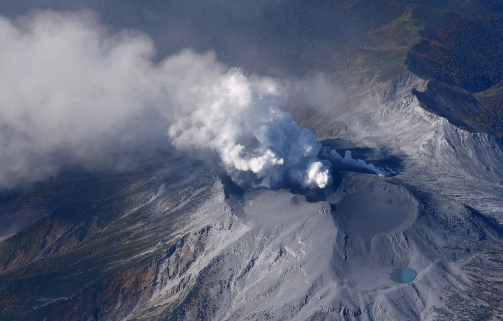
Indonesia , Merapi :
VOLCANO OBSERVATORY NOTICE FOR AVIATION – VONA
Issued : January 24 , 2024
Volcano : Merapi (263250)
Current Aviation Colour Code : ORANGE
Previous Aviation Colour Code : orange
Source : Merapi Volcano Observatory
Notice Number : 2024MER002
Volcano Location : S 07 deg 32 min 31 sec E 110 deg 26 min 31 sec
Area : Special Region of Yogyakarta, Indonesia
Summit Elevation : 9498 FT (2968 M)
Volcanic Activity Summary :
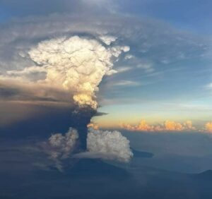
Eruption with volcanic ash cloud at 08h56 UTC (15h56 local).
Volcanic Cloud Height :
Best estimate of ash-cloud top is around 12698 FT (3968 M) above sea level or 3200 FT (1000 M) above summit. May be higher than what can be observed clearly. Source of height data: ground observer.
Other Volcanic Cloud Information :
Ash cloud moving from east to southeast. Volcanic ash is observed to be gray to brown. The intensity of volcanic ash is observed from medium to thick.
Remarks :
Eruption recorded on seismogram with maximum amplitude 51 mm and maximum duration 168 second. Ash cloud generated by pyroclastic density current (PDC). Ash rain reported at Deles/Kemalang Klaten and Jemowo/Boyolali. Run out distance PDC 1,8 km to the south-west (Kali Bebeng).
SEISMICITY OBSERVATIONS
35 avalanche earthquakes with an amplitude of 3 to 29 mm and a duration of 26.72 to 156.92 seconds.
4 hybrid/multi-phase earthquakes with an amplitude of 3 to 10 mm, and an earthquake duration of 5.6 to 8.28 seconds.
RECOMMENDATION
The current potential danger in the form of lava avalanches and hot clouds in the South-Southwest sector includes the Boyong River up to a maximum of 5 km, the Bedog, Krasak and Bebeng rivers up to a maximum of 7 km. The South-East sector covers the Woro river over a maximum distance of 3 km and the Gendol river over a maximum distance of 5 km. Meanwhile, when an explosive eruption occurs, volcanic material can reach a radius of 3 km around the summit.
Source : Magma Indonésie.
Photo : Andi Volcanist.
Japan , Suwanosejima :
JMA reported that the eruption at Suwanosejima’s Ontake Crater continued during 16-22 January and crater incandescence was observed nightly. The Alert Level was lowered to 2 at 11h00 on 19 January because the probability of material being ejected more than 1 km laterally had decreased. There were seven explosions detected from 17h59 on 19 January to 12h22 on 22 January. Details about the plumes were reported for two of them and unknown for the remaining ones; on 21 January an explosion at 16h32 produced an ash plume that rose 1 km above the crater rim and drifted SE and an explosion at 22h15 produced an ash plume that rose 600 m above the crater rim before merging into weather clouds. The public was warned to stay 1 km away from the crater.
The 8-km-long island of Suwanosejima in the northern Ryukyu Islands consists of an andesitic stratovolcano with two historically active summit craters. The summit is truncated by a large breached crater extending to the sea on the east flank that was formed by edifice collapse. One of Japan’s most frequently active volcanoes, it was in a state of intermittent Strombolian activity from Otake, the NE summit crater, between 1949 and 1996, after which periods of inactivity lengthened. The largest recorded eruption took place in 1813-14, when thick scoria deposits blanketed residential areas, and the SW crater produced two lava flows that reached the western coast. At the end of the eruption the summit of Otake collapsed, forming a large debris avalanche and creating the open Sakuchi caldera, which extends to the eastern coast. The island remained uninhabited for about 70 years after the 1813-1814 eruption. Lava flows reached the eastern coast of the island in 1884. Only about 50 people live on the island.
Source : Agence météorologique japonaise (JMA), GVP
Photo : Masanori Genko
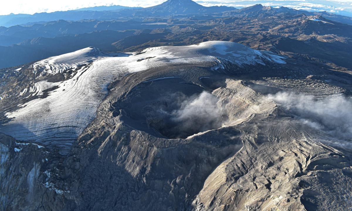
Colombia , Nevado del Ruiz :
Weekly bulletin on the activity of the Nevado del Ruiz volcano
From the monitoring of the activity of the NEVADO DEL RUIZ VOLCANO, the MINISTRY OF MINES AND ENERGY through the COLOMBIAN GEOLOGICAL SERVICE (SGC) reports that:
In the week of January 16 to 23, 2024, the volcano continued with unstable behavior characterized by low levels of activity, as evidenced by the decrease in seismic activity and the degassing of sulfur dioxide (SO2), and the persistence of thermal anomalies at the bottom of Arenas crater. Compared to the previous week, the main variations in the parameters monitored were:
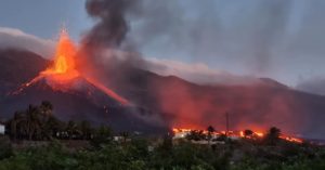
– Seismicity associated with the fracturing of rocks inside the volcanic edifice has decreased in the number of earthquakes recorded and increased in seismic energy released. The earthquakes were located mainly in the Arenas crater and on the northeast flank of the volcano, at distances less than 6 km from the crater. To a lesser extent, the earthquakes were located in the South-East and South-West sectors. The depth range of the events varied between 1 and 6 km from the volcano summit. The highest magnitude of the week was 1.2, corresponding to the earthquake of January 19 at 3:11 a.m., located approximately 3 km north of the volcanic structure, at a depth of 6 km. In addition, low-energy seismicity related to the activity was recorded on the lava dome (protrusion or mound) located at the bottom of the crater.
– Seismic activity linked to pulsatile emissions of ash and gas into the atmosphere has decreased in the number of earthquakes recorded and in the seismic energy released. Seismic signals of this type had low to moderate energy levels. Thanks to the cameras used to monitor the volcano, it was possible to confirm several emissions of ash or changes in the relative temperature of the emitted material associated with some of these seismic signals. The signal from January 20 at 8:57 p.m. stands out. because it is the one with the highest energy level and is associated with the highest gas and ash column height of the week. Regarding this signal, several reports have been published of heavy ash falls near the volcano and in the municipalities of Villamaría and Manizales.
– Sulfur dioxide (SO2) outgassing rates were variable and decreased slightly. The maximum height of the gas or ash column was 1,000 m vertical and 2,000 m dispersed.
These values were measured at the summit of the volcano on January 20, 2024 and were associated with the emission of ash recorded at 8:57 p.m. The direction of dispersion of the columns predominated towards the northwest to west flank of the volcano.
– In monitoring thermal anomalies at the bottom of Arenas Crater, from satellite monitoring platforms, the increase in the number of detections and energy levels continued as well as the maximum energy levels recorded.
In the early hours of today there was a record of the highest energy value since this parameter has been monitored on the volcano (since 2007), which shows the presence of magmatic material near the surface, such as this has been mentioned many times before.
Source et photo : SGC
Alaska , Great Sitkin :
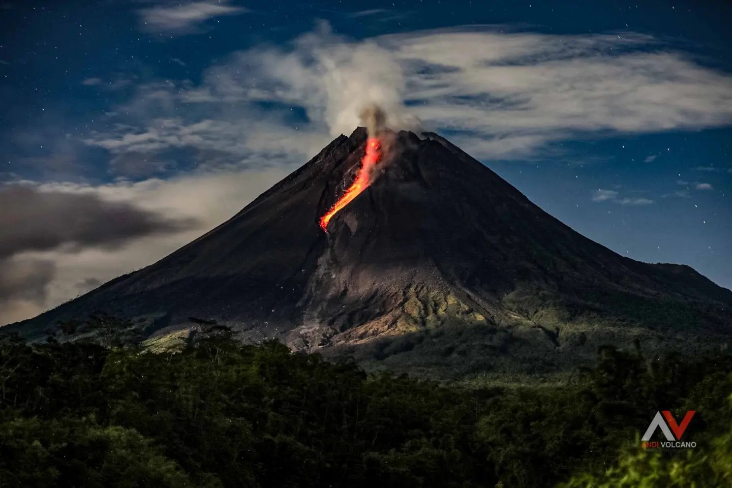
Slow eruption of lava in the summit crater of Great Sitkin Volcano continues. No notable observations were made in cloudy satellite images over the last day. Local monitoring network data feed restoration is in progress after a storm-related power failure.
The current lava flow began erupting in July 2021. No explosive events have occurred since a single event in May 2021.
Local seismic and infrasound sensors and web cameras are used to monitor Great Sitkin, when available. We are currently using regional infrasound and lightning networks as well as satellite data.
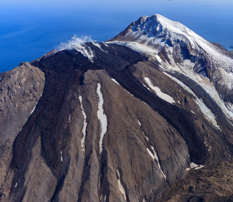
AVO reported that the eruption of lava at Great Sitkin’s summit lava dome continued during 16-23 January, confirmed by a few radar images acquired during the week. Effusion was concentrated at the center of the dome with minimal advancement at the margins of the flow. Weakly elevated surface temperatures were identified in satellite data during 16-18 January. Local webcams and seismic data communications were offline due to a storm-related power failure. The Volcano Alert Level remained at Watch (the third highest level on a four-level scale) and the Aviation Color Code remained at Orange (the third highest color on a four-color scale).
Source : AVO , GVP
Photo : Loewen, Matt
Mexico , Popocatepetl :
Activity from the last 24 hours
Eight exhalations were detected and an additional 1,217 minutes of high-frequency, low-amplitude tremors were identified; Both volcanic events were accompanied by water vapor, other gases and ash. Similarly, three volcanotectonic earthquakes were recorded today at 07:02:21, 07:02:40 and 08:51 h.
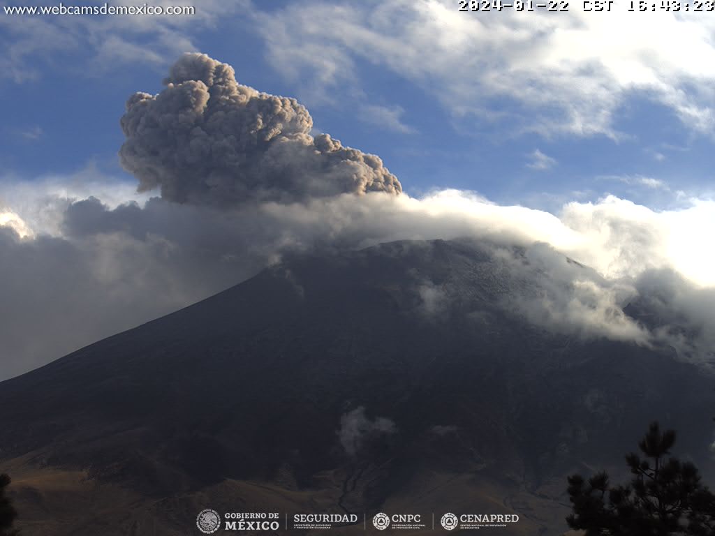
Yesterday, at 12:30 p.m. (local time), the National Center for Communication and Operation of Civil Protection (Cenacom) reported light ash falls in the municipalities of San Nicolás de los Ranchos and Nealtican, also between 12:00 p.m. and 5:00 p.m. , operations were suspended at Hermanos Serdán International Airport due to the presence of volcanic ash.
During the morning and at the time of this report, a continuous emission of water vapor and volcanic gases is observed, with dispersion towards the North-East (NE).
The Popocatépetl volcanic warning fire is in yellow phase 2.
Source et photo : Cenapred.