November 9 , 2021.
Spain / La Palma , Cumbre Vieja :
November 08, 2021, 09:00 UTC. Eruptive activity continues on La Palma.
Since the last declaration, 62 earthquakes have been located in the area affected by the volcanic reactivation of Cumbre Vieja, 7 of these earthquakes were felt by the population, having reached the maximum intensity of IV (EMS98) in the epicentral zone.
The most significant earthquake was the one which occurred at 17:07:10 (UTC) yesterday, with a magnitude of 4.6 mbLg at a depth of 37 km and felt with intensity IV on the island of La Palma. 8 seconds later, another 4.5 magnitude earthquake was located in the same area, 38 km deep, thus forming a double earthquake.
In the period considered, 7 earthquakes were located at a depth of about 30 km, the rest of the hypocenters of the period are located at a shallower depth, at about 12 km.
The amplitude of the volcanic tremor signal has significantly decreased, with low average levels and no intensifying pulse.
The island’s network of permanent GNSS stations shows that the inflation recorded on the 4th and 5th at station LP03, which is closest to the eruptive centers, has returned to a lower level than previously established. The southwest deformation recorded at the station continues.
In the rest of the stations, a slight deflation persisted, possibly linked to deep seismicity.
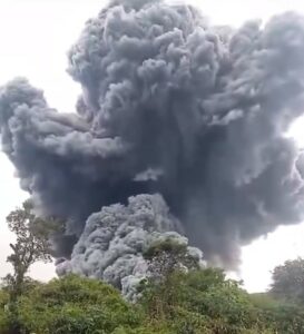
In view of the calibrated image, a column height of 2,500 m is estimated at 08:45 UTC, with a southwest direction.
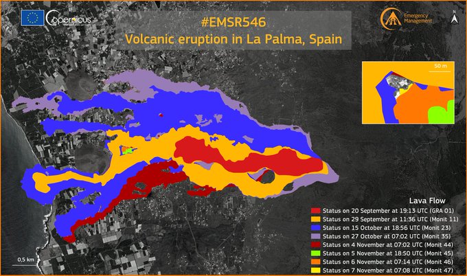
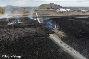
Lava flows flow over previous ones, without invading new surfaces. Almost all the flow of volcanic material goes to the main flow, which was the one that reached the sea.
The two lava flows that worry experts the most are 8, which have been in La Laguna since October 23; and 14, which would close the authorities’ current access to Puerto Naos. For the moment, the two continue to be arrested.
The maximum width of the lava flows reaches 3,100 meters.
The height of the ash plume reaches 2,500 meters in height and is scattered to the west and southwest. It is expected to continue like this, which is good for the activity at the airport.
Seismicity remains low compared to previous weeks, and is located at a depth of 15 kilometers on average. The maximum magnitude was 4.6 yesterday afternoon. A downward trend is observed.
The tremors and distortions also maintain a downward trend.
Sulfur dioxide emissions reach values between 16,600 and 23,100 tonnes per day. These levels remain high, but the evolution over time reflects a downward trend.
The magmatic contribution has a more superficial origin.
Experts from the Canary Islands Volcanic Emergency Plan (Pevolca) scientific committee are studying the signs of exhaustion of magmatic inputs at greater depths and have found that the lava coming out now has a more shallow origin. Pevolca spokeswoman Carmen López explained that all observable data (chemical composition of the plume, seismicity and deformation of the terrain) indicate that the system is « slacking off » and that the lava reserves « are getting smaller ». López abounded in the fact that « all observable data coincides with the deepest part » of this system which feeds the volcano which « is less active and has less capacity to feed in magma, to feed the eruption for longer » . One of these indications is the declining trend in sulfur dioxide emissions. The others are low seismicity and a volcanic tremor signal, as well as a downward trend in terrain deformation. Despite these indications, López said that « we have to wait a while » for these parameters to stabilize to confirm their downward trend and make it predictable that the end of the eruption is nearer.
Source : IGN es ,El Pais .
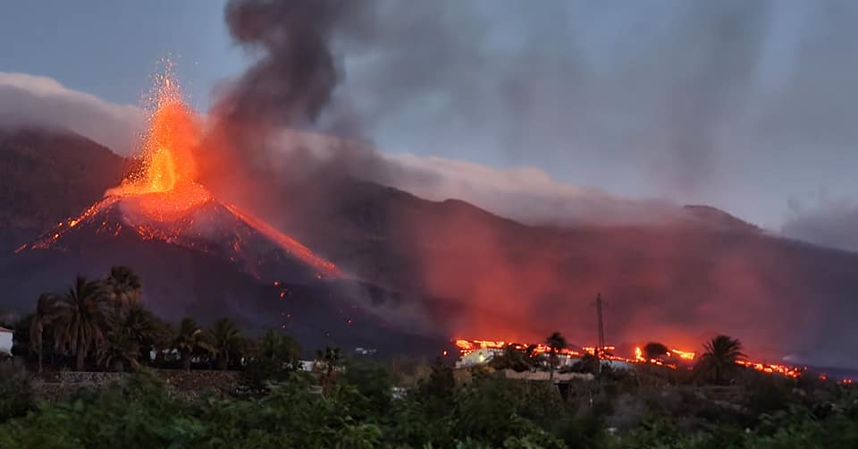
Photos : Dominic Blaser , Adriana Felker
Carte : Copernicus.
Peru , Sabancaya :
Analysis period: from November 02, 2021 to November 07, 2021, Arequipa, November 08, 2021.
Alert level: ORANGE
The Geophysical Institute of Peru (IGP) reports that the eruptive activity of the Sabancaya volcano remains at moderate levels, that is to say with the recording of an average of 64 daily explosions, with columns of ash and gas up to 2.5 km altitude above the summit of the volcano and their consequent dispersion. Therefore, for the following days, no significant change is expected in eruptive activity.
The IGP recorded and analyzed the occurrence of 817 earthquakes of volcanic origin, associated with the circulation of magmatic fluids within the Sabancaya volcano. An average of 64 explosions was recorded daily. During this period, Volcano-Tectonic (VT) earthquakes associated with rock fractures were located mainly in the Northwest, Northeast and North of Sabancaya and presented magnitudes between M 2.0 and M 3.6.
The monitoring of the deformation of the volcanic structure using GNSS techniques (processed with fast orbits) does not present any significant anomalies. However, in general, an inflation process was observed in the northern sector (around the Hualca Hualca volcano). Visual surveillance made it possible to identify columns of gas and ash up to 2.5 km altitude above the summit of the volcano, which were scattered towards the South-East, South-West, West and North sectors – East of Sabancaya. Satellite recordings have identified the presence of 11 thermal anomalies (maximum value of 30 MW) associated with the presence of a lava body on the surface of the volcano’s crater.
RECOMMENDATIONS
• Keep the volcanic alert level in orange.
• Do not approach within a radius of 12 km from the crater.
Source et photo : IGP.
Philippines , Taal :
TAAL VOLCANO BULLETIN 09 November 2021 8:00 AM
In the past 24-hour period, the Taal Volcano Network recorded one hundred eleven (111) volcanic earthquakes, including twenty-six (26) volcanic tremor events having durations of one (1) to two (2) minutes, eighty-five (85) low-frequency volcanic earthquakes, and low-level background tremor that has persisted since 7 July 2021. Activity at the Main Crater was dominated by upwelling of hot volcanic fluids in its lake which generated plume 1500 meters tall that drifted southwest. Sulfur dioxide (SO2) emission averaged 11,435 tonnes/day on 08 November 2021. Based on ground deformation parameters from electronic tilt, continuous GPS and InSAR monitoring, Taal Volcano Island has begun inflating in August 2021 while the Taal region continues to undergo very slow extension since 2020.
Alert Level 2 (Increased Unrest) prevails over Taal Volcano. DOST-PHIVOLCS reminds the public that at Alert Level 2, sudden steam- or gas-driven explosions, volcanic earthquakes, minor ashfall, and lethal accumulations or expulsions of volcanic gas can occur and threaten areas within and around TVI.
Source : Phivolcs.
Photo : Val Cuenca, ABS-CBN News
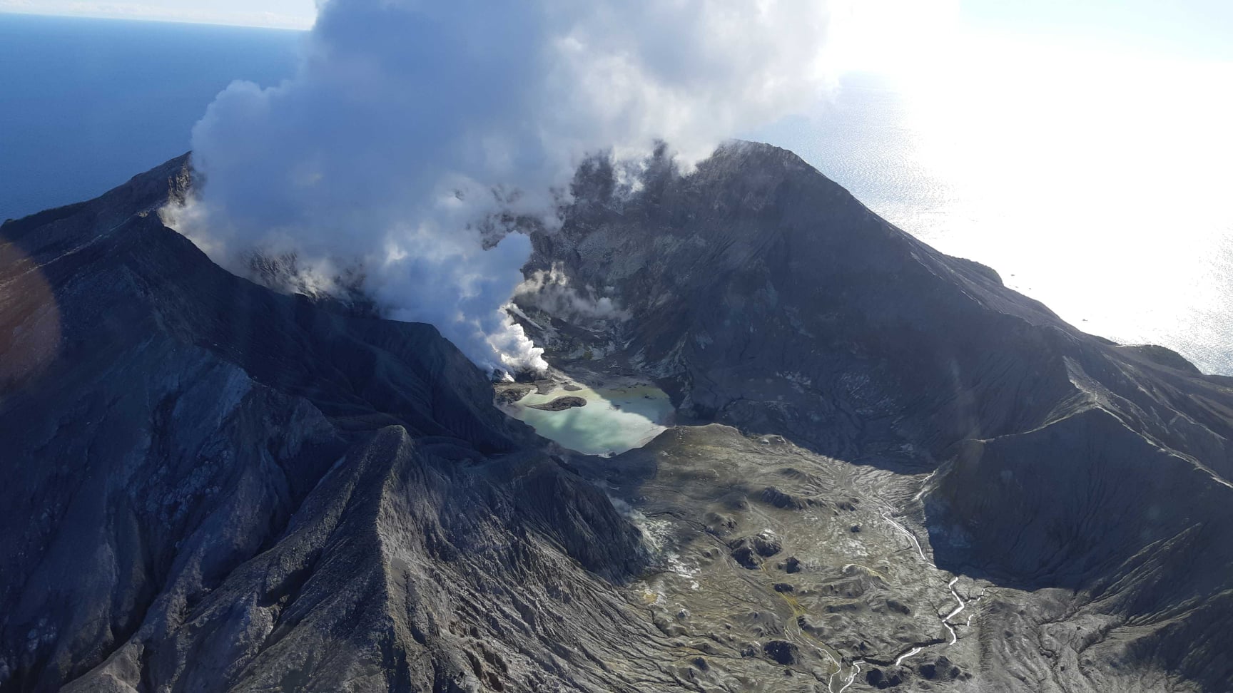
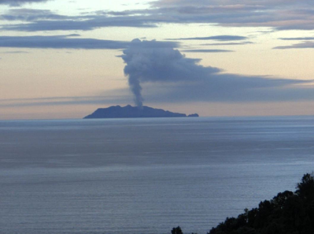
New Zealand , White Island :
Whakaari/White Island: Volcanic unrest continues, increased gas emission, steady active vent temperatures and lake level rise. Published: Tue Nov 9 2021 2:00 PM
Volcanic Alert Level remains at 2
Aviation Colour Code remains at Yellow
Recent gas and observation flights at Whakaari / White Island show increases in gas emissions and lake level. The vent temperatures remain steady around 200-220 °C. The volcano occasionally emits traces of volcanic ash and remains in a state of moderate to heightened unrest. The Volcanic Alert Level remains at Level 2.
Last week GNS scientists undertook a visual observation flight and a gas emission measurement flight. Temperature measurements of the active vent area were also made.
The gas measurements showed that emissions of volcanic gases have increased since the last measurements on 14 October. Sulphur Dioxide (SO2) has increased to 681 tonnes per day from 267 tonnes per day in mid-October. The emissions of Carbon Dioxide (CO2) increased from 757 to 2712 tonnes per day, while the Hydrogen Sulphide (H2S) also showed an increase, from 10 to 38 tonnes per day. These data show another pulse of gas escaping from the molten material at depth in the volcano.
Temperatures measured in the active vent area ranged from 252 °C to 202 °C during September-October. In July and August, the temperatures were in excess of 500-600 °C.
The level of water in the crater lake is slightly higher than we observed in late October. Nearly all of this rise is due to heavy rainfall.
Very weak ash emission was occurring during the observations last week, but the recent deposits are minor and only visible close to the active vents. Intermittent ash emission is still possible. The recent cloudy and humid weather conditions are allowing spectacular steam and gas plumes to be seen above the island, but also the weather is often obscuring views from the coast.
Seismic activity from the degraded site remains similar, with low levels of volcanic tremor and occasional low-frequency volcanic earthquakes.
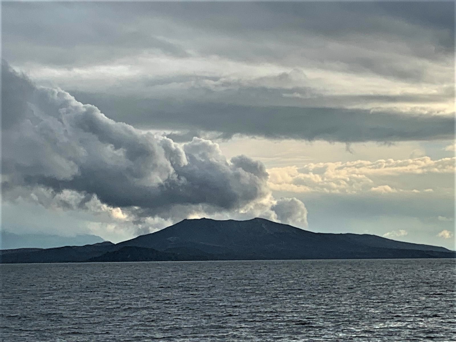
Steam and gas plume above White Island/Whakaari on Nov 7, 7.30 pm NZDT
The current level of activity is consistent with moderate to heightened levels of unrest. As such the Volcanic Alert Level remains at 2 and the Aviation Colour Code remains at Yellow.
Equipment that provides real-time monitoring on the island remains degraded. We are continuing to work on restoration options.
The Volcanic Alert Level reflects the current level of volcanic unrest or activity and is not a forecast of future activity. While Volcanic Alert Level 2 is mostly associated with volcanic unrest hazards (including discharge of steam and hot volcanic gases, earthquakes, landslides, and hydrothermal activity), potential for eruption hazards also exists and eruptions can still occur with little or no warning.
Source : Geonet / Mike Rosenberg / Duty Volcanologist .
Photos : Geonet.
Alaska , Pavlof :
55°25’2″ N 161°53’37 » W,
Summit Elevation 8261 ft (2518 m)
Current Volcano Alert Level: WATCH
Current Aviation Color Code: ORANGE
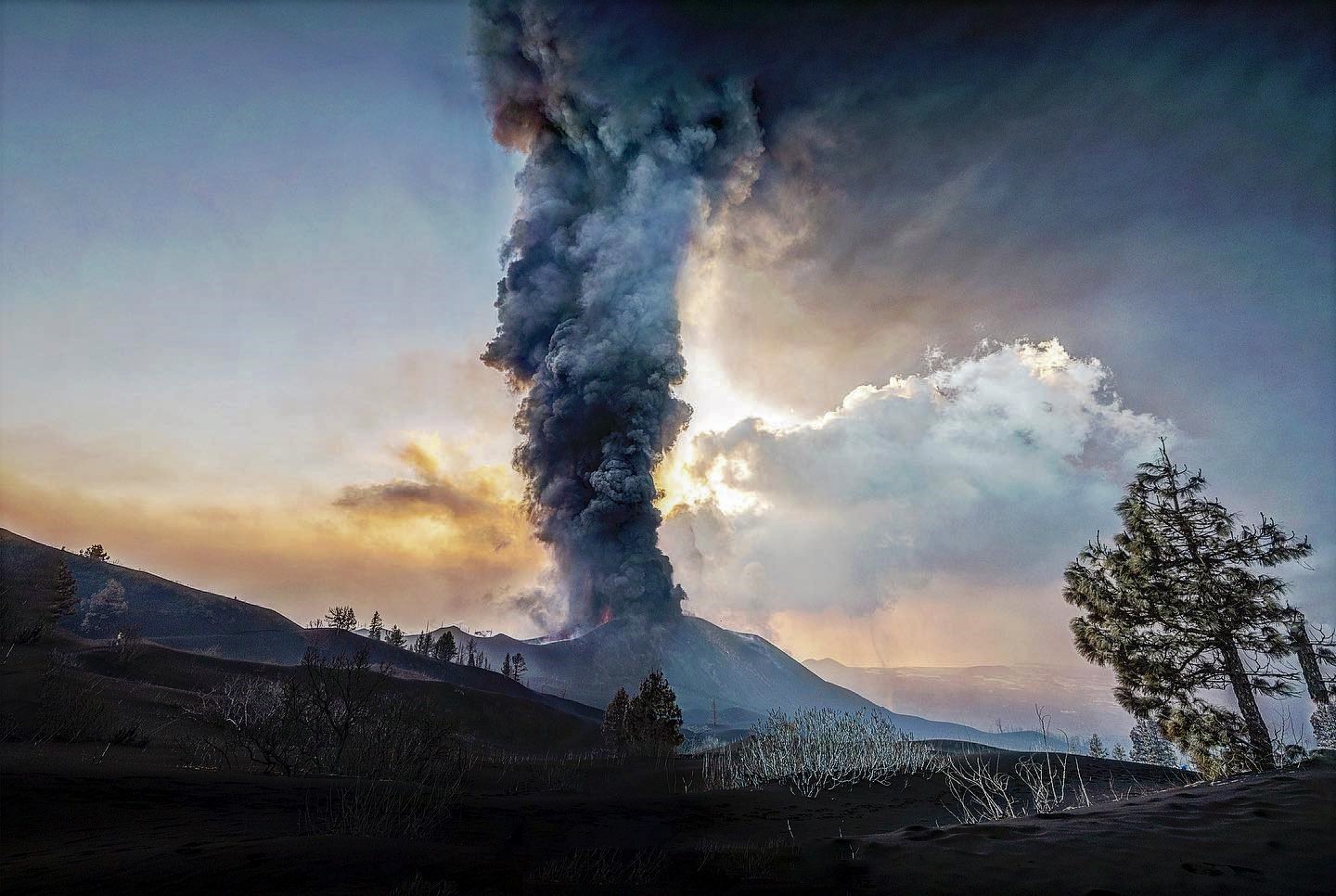
Small explosions were detected overnight and this morning at Pavlof, along with elevated surface temperatures from emplacement of a small 30 m-long lava flow from the current vent NE of the summit. No ash clouds or deposits were visible in satellite or clear webcam images over the last day, however, small ash emissions could have occurred between camera acquisitions and dissipated quickly near the vent location, similar to previous explosive events during the current eruption.
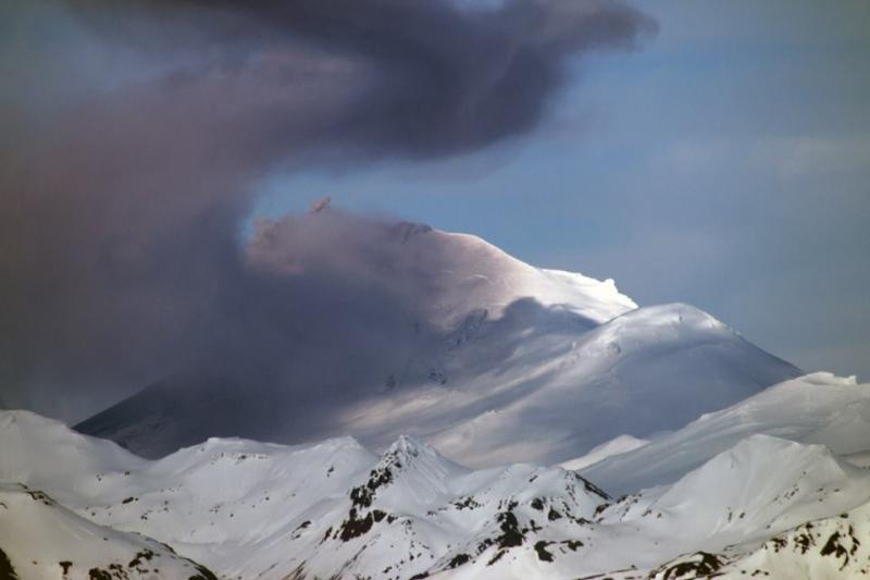
Minor ash emission from Pavlof Volcano as viewed from Cold Bay. Photo courtesy of Royce Snapp.
Small explosions accompanied by low-level ash emissions could happen at any time, and are typically a hazard in the immediate vicinity of the summit. The level of unrest at Pavlof can change quickly and the progression to more significant eruptive activity can occur with little or no warning.
Pavlof is monitored by local seismic and infrasound sensors, satellite data, web cameras, and remote infrasound and lightning networks.
Source : AVO.
Photo : Snapp, Royce / AVO.