November 10 , 2023.
Islande , Peninsule de Reykjanes :
Earthquake of M4.8 measured last night. The size of earthquakes does not necessarily mean an increased rate of magma accumulation. Around 1400 earthquakes in the last 24 hours.Updated 9. November at 12:20pm
Around 1400 earthquakes have been recorded in the last 24 hours. Seismic activity increased from midnight, and the SIL seismic network has detected seven earthquakes above M4.0 since then. The largest earthquake measured M4.8 at 12:46am. It was located west of Þorbjörn. It is the largest earthquake since the activity began on October 25th. Seven earthquakes M4.0 or larger in size were measured in the area from Eldvörp to the area east of Sýlingarfell. While the accumulation of magma continues, seismic activity can be expected on the Reykjavík Peninsula because the magma intrusion causes increased tension in the area.
According to GPS data at midnight, uplift continues in the area. The GPS data is being reviewed in relation to the seismic activity tonight. Since the beginning of the inflation until today, the uplift has been fairly even, although an acceleration of the process has been observed between days. The seismic activity last night and this morning is an example of this episodic seismic activity that can be expected while magma accumulation is in progress. The fact that there are now larger earthquakes than before in the area does not necessarily mean an increased rate of magma accumulation.
About 200 earthquakes have been measured since midnight, all under M2,0. The largest event of this swarm was on the 9th, M4.8 at 00:46 just west of Mt. Þorbjörn.
Source et photo : IMO
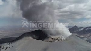
Chile , Llaima :
Special Report on Volcanic Activity (REAV), Auracania region, Llaima volcano, November 9, 2023, 9:40 a.m. local time (mainland Chile)
The National Geology and Mining Service of Chile (Sernageomin) announces the following PRELIMINARY information, obtained through the monitoring equipment of the National Volcanic Monitoring Network (RNVV), processed and analyzed at the Andes del Sud Volcanological Observatory ( Ovdas):
On Thursday, November 9, 2023 at 9:01 a.m. local time (12:01 p.m. UTC), monitoring stations installed near the Llaima volcano recorded an earthquake associated with fracturing of rocks inside the volcanic system (volcano-tectonic type).
The characteristics of the earthquake after its analysis are as follows:
ORIGINAL TIME: 09:01 local time (12:01 UTC)
LATITUDE: 38.814°S
LONGITUDE: 71.711°E
DEPTH: 6.4 km
LOCAL MAGNITUDE: 3.1 (ML)
Comments:
Following the main event, lower energy events were recorded. At the same time, it is reported that the earthquake was felt by the population near the epicenter.
The technical volcanic alert remains at the Green level.
Llaima, one of Chile’s largest and most active volcanoes, contains two main historically active craters, one at the summit and the other, Pichillaima, to the SE. The massive, dominantly basaltic-to-andesitic, stratovolcano has a volume of 400 km3. A Holocene edifice built primarily of accumulated lava flows was constructed over an 8-km-wide caldera that formed about 13,200 years ago, following the eruption of the 24 km3 Curacautín Ignimbrite. More than 40 scoria cones dot the volcano’s flanks. Following the end of an explosive stage about 7200 years ago, construction of the present edifice began, characterized by Strombolian, Hawaiian, and infrequent subplinian eruptions. Frequent moderate explosive eruptions with occasional lava flows have been recorded since the 17th century.
Source : Sernageomin. GVP
Photo : Wikipedia.
Kamchatka , Klyuchevskoy :
56.06 N, 160.64 E;
Elevation 4750 m (15580 ft)
Aviation Colour Code is YELLOW
A fumarole activity of the volcano continues. Collapses of old pyroclastic material from the sides of the Apakhonchich chute are possible with ash rising up to 6 km a.s.l. Ongoing activity could affect low-flying aircraft.
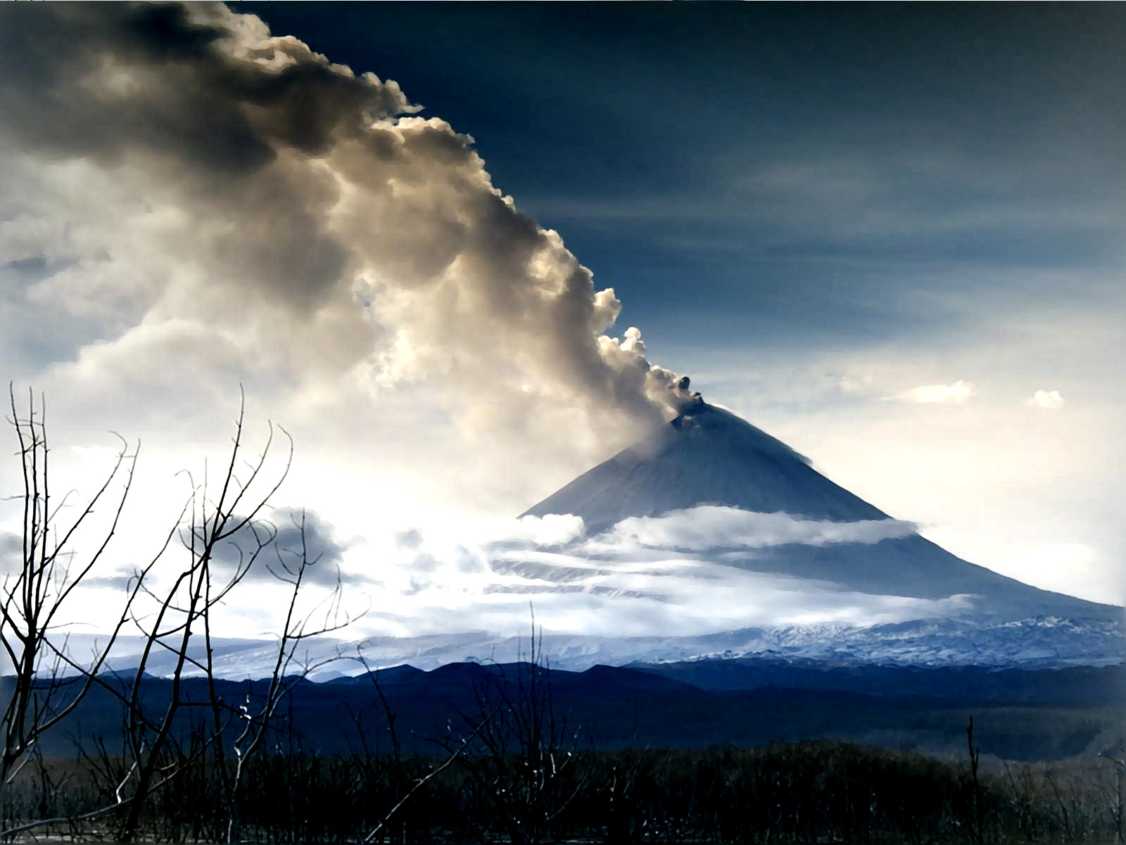
The volcanic eruption, which lasted from 22 June to 05 November, has ended, only fumarole activity of the summit crater is observed. However, a large hot lava flow lying in the Apakhonchichsky chute, continues to provoke the collapses of old pyroclastic material from the sides of the chute. Satellite data by KVERT showed a thermal anomaly over the volcano associated with the cooling of lava flows all week; on November 04-05 and 08-09, ash plumes associated with the collapses of old pyroclastic material from the sides of the Apakhonchichsky chute (resuspended ash) extended for about 260 km, respectively, to the northeast and southeast of the volcano.
Source : Kvert
Photo : Andrew Matseevsky ( 25 Octobre)
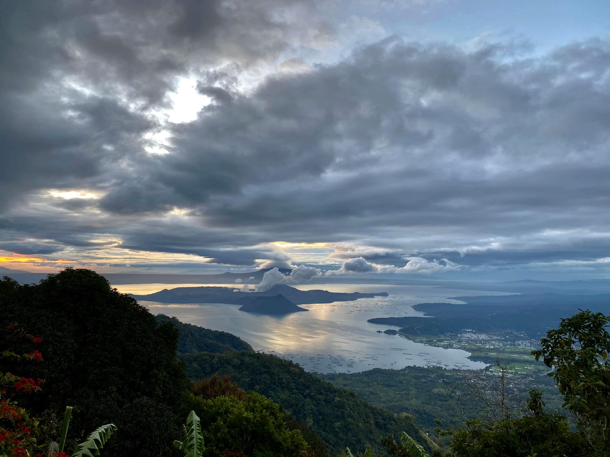
Philippines , Taal :
TAAL VOLCANO ADVISORY , 09 November 2023 , 03:00 PM
This is a notice of increased and continuous degassing activity from Taal Volcano.
A total of 11,499 tonnes/day of volcanic sulfur dioxide or SO2 gas emission from the Taal Main Crater was measured today, 09 November 2023. This is the highest recorded SO2 emission from Taal for the year. Visual monitors show continued pronounced upwelling of volcanic fluids in the Main Crater that generated rather short and weak- to moderate-volume degassing plumes. Strong winds drifted the plumes to the southwest. No volcanic smog or vog over Taal Caldera was observed by visual monitors throughout the day. Nonetheless, PAGASA wind forecasts indicate a probable weakening of wind later in the day and tomorrow, 10 November 2023, which may lead to potential SO2 accumulation and vog formation over the Taal Region. Taal has been continuously degassing high concentrations of volcanic SO2 since March 2021; emissions since September 2023 have averaged 5,019 tonnes/day. Moderate seismicity has been recently exhibited by Taal; of the 415 volcanic earthquakes recorded since 1 September 2023, 362 were weak volcanic tremors associated with volcanic gas activity.
As a reminder, vog consists of fine droplets containing volcanic gas such as SO2 which is acidic and can cause irritation of the eyes, throat and respiratory tract with severities depending on the gas concentrations and durations of exposure.
DOST-PHIVOLCS reminds the public that Alert Level 1 prevails over Taal Volcano, which means that it is still in abnormal condition and should not be interpreted to have ceased unrest nor ceased the threat of eruptive activity. At Alert Level 1, sudden steam-driven or phreatic explosions, volcanic earthquakes, minor ashfall and lethal accumulations or expulsions of volcanic gas can occur and threaten areas within TVI. DOST-PHIVOLCS strongly recommends that entry into TVI, Taal’s Permanent Danger Zone or PDZ, especially the vicinities of the Main Crater and the Daang Kastila fissure, must remain strictly prohibited. Local government units are advised to continuously monitor and assess volcanic SO2 and vog exposure of, and potential impacts on, their communities and undertake appropriate response measures to mitigate these hazards.
Source : Phivolcs
Photo : Raffy Tima ( archive).
Colombie , Nevado del Ruiz :
Manizales, November 9, 2023, 8:50 p.m.
From the monitoring of the activity of the NEVADO DEL RUIZ VOLCANO, the MINISTRY OF MINES AND ENERGY through the COLOMBIAN GEOLOGICAL SERVICE (SGC) reports that:
Today, November 9, from the sulfur dioxide (SO2) measuring stations, a notable increase in the degassing rates of this gas was observed, reaching values that have not been recorded since June 2022. Likewise, in the monitoring of satellite monitoring platforms, a thermal anomaly was recorded at the bottom of the crater with a moderate energy level.
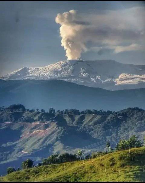
These two simultaneous changes in volcano activity show greater instability of the volcano in recent days compared to previous weeks.
Additionally, as noted in the latest weekly bulletins, other monitored parameters have shown greater variations in recent weeks.
It is important to emphasize that these increases and variations in the activity of the volcano are considered within the framework of the yellow alert state. However, you should not get used to this behavior since, as we have mentioned, the volcano can quickly destabilize, which would cause it to go into an Orange alert state or even into a Red alert state.
The community is recommended to remain calm and pay attention to the information provided by the Colombian Geological Service on the evolution of the state of the volcano.
The alert status of the volcano remains at YELLOW ALERT: ACTIVE VOLCANO WITH CHANGES IN THE BEHAVIOR OF THE BASE LEVEL OF MONITORED PARAMETERS AND OTHER MANIFESTATIONS
Source : SGC
Photo : wilfred Hernandez