January 22 , 2024.
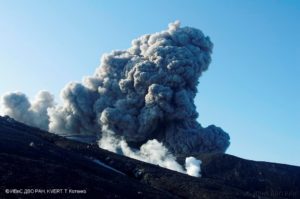
Alaska , Kanaga :
Satellite images over the past this week show no change at the volcano’s summit following the December 18 (December 19 UTC) steam-driven explosive event.
Local monitoring data have been off-line since January 2 due to a storm-related power failure.
This new unrest indicates a possibility for sudden explosions to occur at any time. These explosions may produce ash clouds exceeding 20,000 feet above sea level.
Prior to the current activity, the last unrest at Kanaga Volcano was in February 2012 when a steam-driven explosion occurred together with the opening of a large fissure on the southern crater rim.
Kanaga Volcano is monitored by local seismic and infrasound sensors (when operational), regional infrasound and lightning networks, and satellite data.
Source : AVO
Photo : Loewen, M. W./ AVO / U.S. Geological Survey
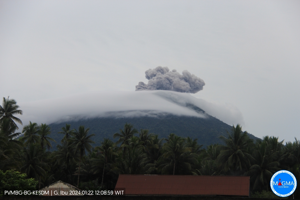
Indonesia , Ibu :
Mount Ibu erupted on Monday, January 22, 2024, at 11:57 p.m. WIT. The height of the eruptive column was observed to be ±500 m above the summit (±1,825 m above sea level). The ash column was gray in color with a thick intensity, oriented towards the South-East. The eruption was recorded on a seismograph with a maximum amplitude of 28 mm and a duration of 73 seconds.
SEISMICITY OBSERVATIONS
32 eruption earthquakes with an amplitude of 15 to 28 mm and a duration of 21 to 129 seconds.
56 emission earthquakes with an amplitude of 2 to 14 mm and earthquake duration of 15 to 50 seconds.
11 harmonic tremors with an amplitude of 2 to 14 mm and an earthquake duration of 35 to 335 seconds.
171 shallow volcanic earthquakes with amplitude of 2 to 14 mm and duration of 4 to 14 seconds.
6 deep volcanic earthquakes with an amplitude of 3 to 10 mm, and an earthquake duration of 5 seconds.
14 distant tectonic earthquakes with an amplitude of 2 to 17 mm, the duration of the earthquakes was 36 to 115 seconds.
RECOMMENDATION
Communities around Mount Ibu and visitors/tourists are advised not to carry out activities within a radius of 2.0 km with a sectoral extension of 3.5 km towards the opening of the crater in the northern part of the crater active Mount Ibu.
Source et photo : Magma Indonesie.
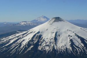
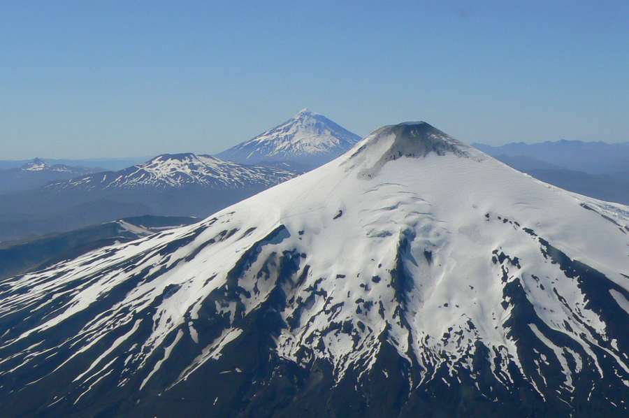
Chile , Villarica :
Special Report on Volcanic Activity (REAV), La Araucanía and Los Ríos regions, Villarrica volcano, January 22, 2024, 02:48 local time (mainland Chile)
The National Geology and Mining Service of Chile (Sernageomin) announces the following PRELIMINARY information, obtained through the monitoring equipment of the National Volcanic Monitoring Network (RNVV), processed and analyzed at the Southern Andean Volcano Observatory (Ovdas):
On Monday, January 18, 2024, at 02:21 local time (5:21 UTC), monitoring stations installed near the Villarrica volcano recorded an earthquake associated with the fracturing of rocks (Volcano-tectonic) inside the volcanic system.
The characteristics of the earthquake after its analysis are as follows:
ORIGINAL TIME: 02:21 local time (05:21 UTC)
LATITUDE: 39.421°S
LONGITUDE: 71.875°E
DEPTH: 5.2 km
LOCAL MAGNITUDE: 3.9 (ML)
Observation :
In the hours preceding the event mentioned in this report, an increase in the occurrence of volcano-tectonic seismicity was recorded, which remains sustained for the moment.
Reports have been received from localities in the vicinity of Pucon mentioning the perception of this earthquake.
No changes in the behavior of the fluid-type seismic activity of the volcano have been recorded, nor any associated surface activity observed.
The technical volcanic alert is maintained at YELLOW level.
Source : Sernageomin.
Photo : ameriquedusud.org.
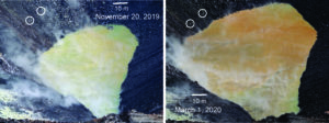
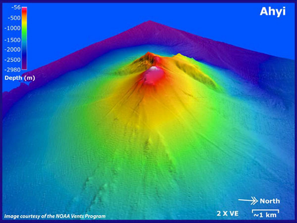
Northern Mariana Islands , Ahyi Seamount :
NMI/USGS Volcanic Activity Notice
Current Volcano Alert Level: ADVISORY
Previous Volcano Alert Level: UNASSIGNED
Current Aviation Color Code: YELLOW
Previous Aviation Color Code: UNASSIGNED
Issued: Sunday, January 14, 2024, 8:50 AM ChST
Source: U.S. Geological Survey
Notice Number: 2024/N5
Location: N 20 deg 25 min E 145 deg 1 min
Elevation: -259 ft (-79 m)
Area: Northern Mariana Islands
Volcanic Activity Summary:
Signs of unrest at Ahyi Seamount have been observed in satellite data over the past few weeks. Plumes of discolored water were observed drifting 1.5–6.2 miles (2.4–10 km) away from the volcano in satellite images on December 24 and 31, 2023 and January 4 and 10, 2024. Nothing significant has been detected from the direction of Ahyi in hydroacoustic array data at Wake Island; however, submarine plumes have been observed at Ahyi in the past without clear hydroacoustic signals. Due to the increased likelihood of an underwater eruption occurring at Ahyi Seamount, the Aviation Color Code and Volcano Alert Level are being raised to YELLOW and ADVISORY. We will continue to monitor satellite and distal hydroacoustic data for additional evidence of volcanic activity.
An undersea eruption at Ahyi Seamount was last detected starting mid-October 2022. The activity appeared to pause beginning in early April 2023 but briefly resumed in late May 2023.
Hazard Analysis:
[Other hazards] Shallow submarine eruptions may present hazards to mariners in the water above the vent.
Remarks:
Ahyi seamount is a large conical submarine volcano that rises to within 450 ft (137 m) of the sea surface about 11 miles (18 km) southeast of Farallon de Pajaros (Uracas) Island in the northern Marianas, about 370 miles (600 km) north of the island of Saipan. In the past, discolored water has been observed over the submarine volcano. In 1979, the crew of a fishing boat felt shocks over the summit area and then observed upwelling of sulfur-bearing water. On April 24-25, 2001 an explosive submarine eruption was detected seismically from a seismic station on Rangiroa Atoll, Tuamotu Archipelago. The event was well constrained (+/- 9 miles or 15 km) at a location near the southern base of Ahyi.
Source : U.S. Geological Survey
Photo : Susan Merle (Oregon State University/NOAA Vents Program). GVP.
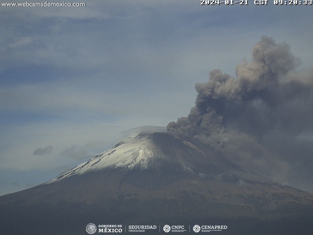
Mexico , Popocatepetl :
January 21, 11:00 a.m. (January 21, 5:00 p.m. GMT)
Activity from the last 24 hours
1255 minutes of high frequency, low amplitude tremors (20.91 h) were recorded, in addition to 27 low intensity expirations. Both volcanic events were accompanied by water vapor, other gases and ash.
During this morning, a continuous emission of water vapor, volcanic gases and ash was observed, which dispersed towards the North.
The Popocatépetl volcanic warning fire is in yellow phase 2.
The scenarios planned for this phase are:
A few small to moderate explosions
Appearance of tremors of variable amplitude
Light to moderate ash rain in surrounding towns and some more distant towns
Ejection of incandescent fragments within the exclusion radius of 12 kilometers
The occurrence of lahars can be expected to descend into the ravines, due to the accumulation of ash on the slopes and its interaction with the rains expected in the coming weeks.
Possibility of pyroclastic flows not reaching populations
Source : Cenapred.