January 07 , 2024 .
Indonesia , Merapi :
Mount Merapi Activity Report, December 29, 2023 – January 4, 2024. Published on January 5, 2024
OBSERVATION RESULTS
Visual
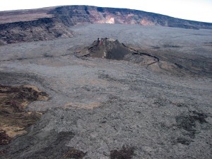
The weather around Mount Merapi is generally clear in the morning, while it is foggy from midday to evening. White smoke, weak to thick, low to moderate pressure and 100 m high was observed from the observation post on Babadan’s Mount Merapi on January 4, 2024 at 05:42 WIB.
This week, 2 warm clouds descended in the South-West (upstream of the Bebeng River) with a maximum sliding distance of 1,800 m. Lava avalanches were observed 83 times in the South and Southwest, including 6 times upstream of the Boyong River over a maximum distance of 1,400 m and 77 times upstream of the Bebeng River over a maximum distance of 2,000 m. mr. The sound of avalanches was heard 7 times from the Babadan post with low to moderate intensity.
Based on the analysis of aerial photos dated December 20, 2023, the volume of the southwest dome was measured at 2,948,100 m3 and that of the central dome at 2,358,400 m3.
Seismicity
This week, Mount Merapi seismicity recorded:
2 warm cloud avalanche (APG) earthquakes,
79 multi-phase (MP) earthquakes,
617 avalanche earthquakes (RF)
15 tectonic earthquakes (TT).
The intensity of earthquakes this week is higher compared to last week.
Deformation
The deformation of Mount Merapi monitored by EDM and GPS this week did not show significant changes in deformation.
Rain and lahars
This week there was rain around the summit of Mount Merapi which was recorded from the Pasarbubar rain station with the highest intensity of 39 mm/hour for 33 minutes on December 31, 2023, then additional flow was reported in the Senowo and Gendol rivers. On January 4, 2024, rainfall around the peak was also recorded at 14 mm/hour for 199 minutes and then additional flow was reported in the Gendol River.
Conclusion
Based on the results of visual and instrumental observations, it was concluded that:
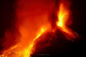
Volcanic activity at Mount Merapi is still quite high in the form of effusive eruptive activity. The activity status is set to the “SIAGA” level.
Source : BPPTKG
Photo : John Bamforth / FB.
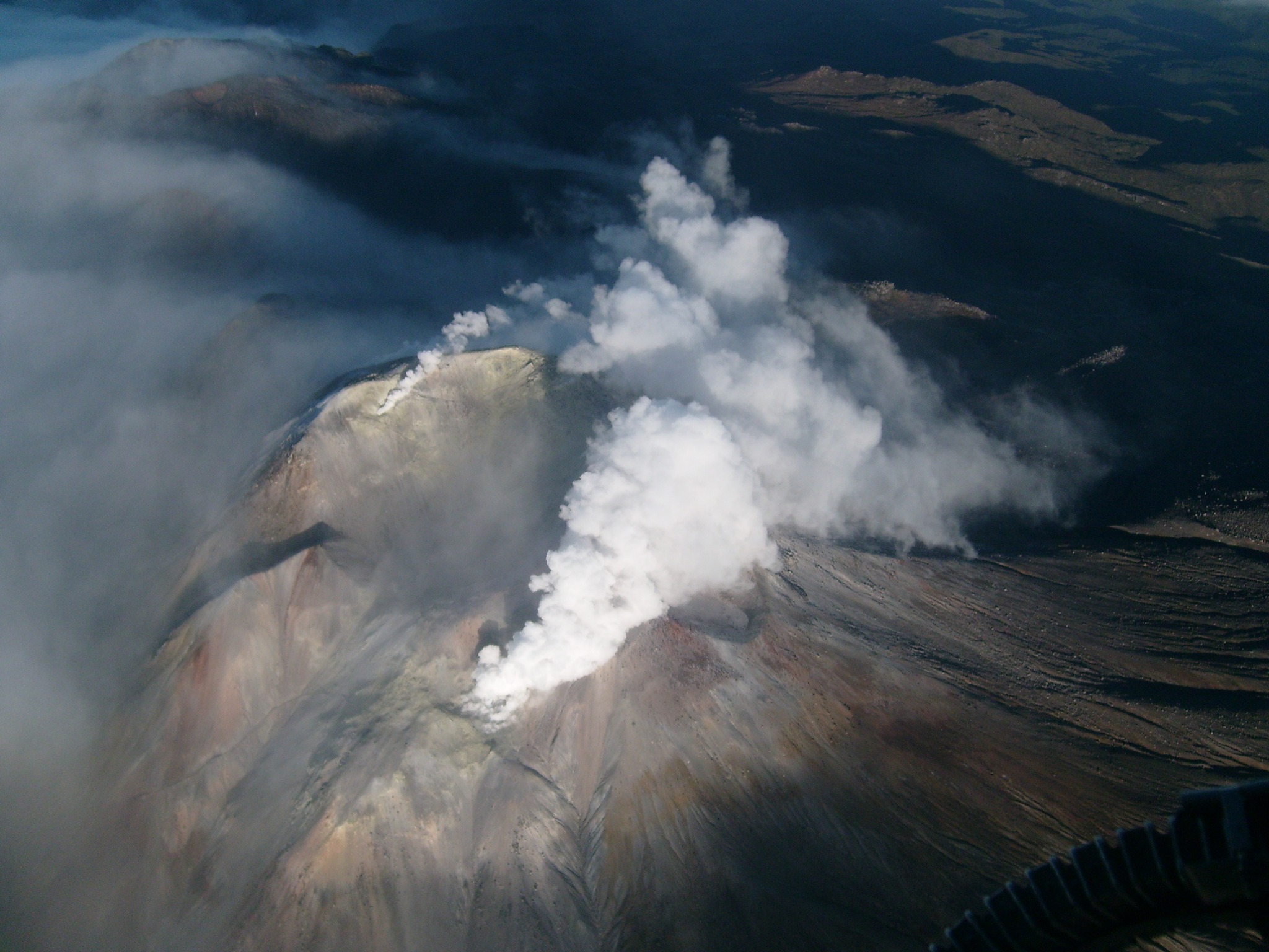
Chile , Laguna del Maule :
Seismology
The seismological activity of the period was characterized by the recording of:
1492 seismic events of type VT, associated with the fracturing of rocks (Volcano-Tectonics). The most energetic earthquake had a Local Magnitude (ML) value equal to 3.6, located 0.7 km north-northwest of the volcanic edifice, at a depth of 7.7 km from the crater .
17 LP type seismic events, associated with fluid dynamics inside the volcanic system (Long Period type). The size of the largest earthquake evaluated from the Reduced Displacement (RD) parameter was equal to 80 cm2.
2 HB type seismic events, associated with both rock fracturing and fluid dynamics within the volcanic system (Hybrid type). The most energetic earthquake presented a Reduced Displacement (DR) value of 38 cm2 and a Local Magnitude (ML) value equal to 2.6, located 14.5 km South-South-East of the volcanic edifice. , at a depth of 3.6 km in reference to the crater.
Fluid geochemistry
No anomalies have been reported in emissions of sulfur dioxide (SO2) into the atmosphere in the area near the volcanic complex, according to data published by the Tropospheric Monitoring Instrument (TROPOMI) and the Ozone Monitoring Instrument (OMI) .
Satellite thermal anomalies
During the period, no thermal alerts were recorded in the area associated with the volcanic complex, according to the analytical processing of Sentinel 2-L2A satellite images, in combination of false color bands.
Geodesy
From the 4 GNSS stations operating on the volcanic complex, we observe that the inflationary process continues. The maximum vertical deformation rate for this period is 1.12 cm/month, slightly higher than the previous period, which was considered high. In turn, horizontal deformation rates have a maximum of 0.75 cm/month, considered of medium magnitude.
On the other hand, from radar interferometry (Terra2 platform), the uplift of the volcanic complex area is partially observed, without substantial changes compared to what was observed during previous periods.
The volcanic complex remains at high levels of volcanotectonic seismicity occurrence.
The locations of the VT earthquakes obtained are distributed among three sources located in the East, North and Center sectors of the lagoon, in relation to the latter. The process of cortical deformation remains active with uplift rates within the historically recorded average. These conditions allow us to deduce that the volcanic system is still above its base threshold and therefore, its technical alert is maintained at:
YELLOW TECHNICAL ALERT: Changes in the behavior of volcanic activity.
Source : Sernageomin
Photo : auteur inconnu
Colombia , Cumbal :
Weekly activity bulletin from the Cumbal Volcanic Complex
Regarding the monitoring of the activity of the CUMBAL VOLCANIC COMPLEX (CVC), the MINISTRY OF MINES AND ENERGY, through the COLOMBIAN GEOLOGICAL SERVICE (SGC), reports that:
For the period between December 26, 2023 and January 1, 2024, and compared to the previous week, seismicity in the CVC showed fluctuations in both the number of earthquakes and the seismic energy released while remaining at low levels. Earthquakes associated with fracturing of rocks within the volcanic complex predominated. The earthquakes were located near the complex, northwest of the La Plazuela crater and west of the Mundo Nuevo crater.
During the week it was possible to observe columns of gas emissions originating mainly from the fumarole fields of El Verde and Los Rastrojos (respectively to the Northeast and Southwest of the CVC). These presented columns of white color, of varying height and dispersion depending on the predominant wind direction. No significant variation was observed in the other geophysical and geochemical parameters of volcanic monitoring.
Volcanic activity remains on YELLOW ALERT Status: Active volcano with changes in baseline behavior of monitored parameters and other manifestations.
Source et photo : SGC
Indonesia , Marapi :
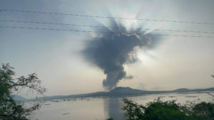
The Geological Agency of the Ministry of Energy and Mineral Resources (ESDM) said that Mount Marapi, located in West Sumatra, experienced another eruption on Friday (05/01/2024). The last eruption occurred at 12:18 WIB with an eruption amplitude of 8.3 mm and an eruption duration of approximately 36 seconds.
Volcanology and Geological Disaster Mitigation Center (PVMBG) Volcano Observation Team Leader Heruningtyas Desi Purnamasari revealed that Mount Marapi still frequently emits ash. Volcanic ash from Mount Marapi has temporarily forced the closure of Minangkabau International Airport (BIM).
« Volcanic ash reaching the airport depends on the wind direction. However, our recommendation remains in line with the activity level of Marapi, namely Level II (WASPADA), » he told CNBC Indonesia, Friday January 5, 2024.
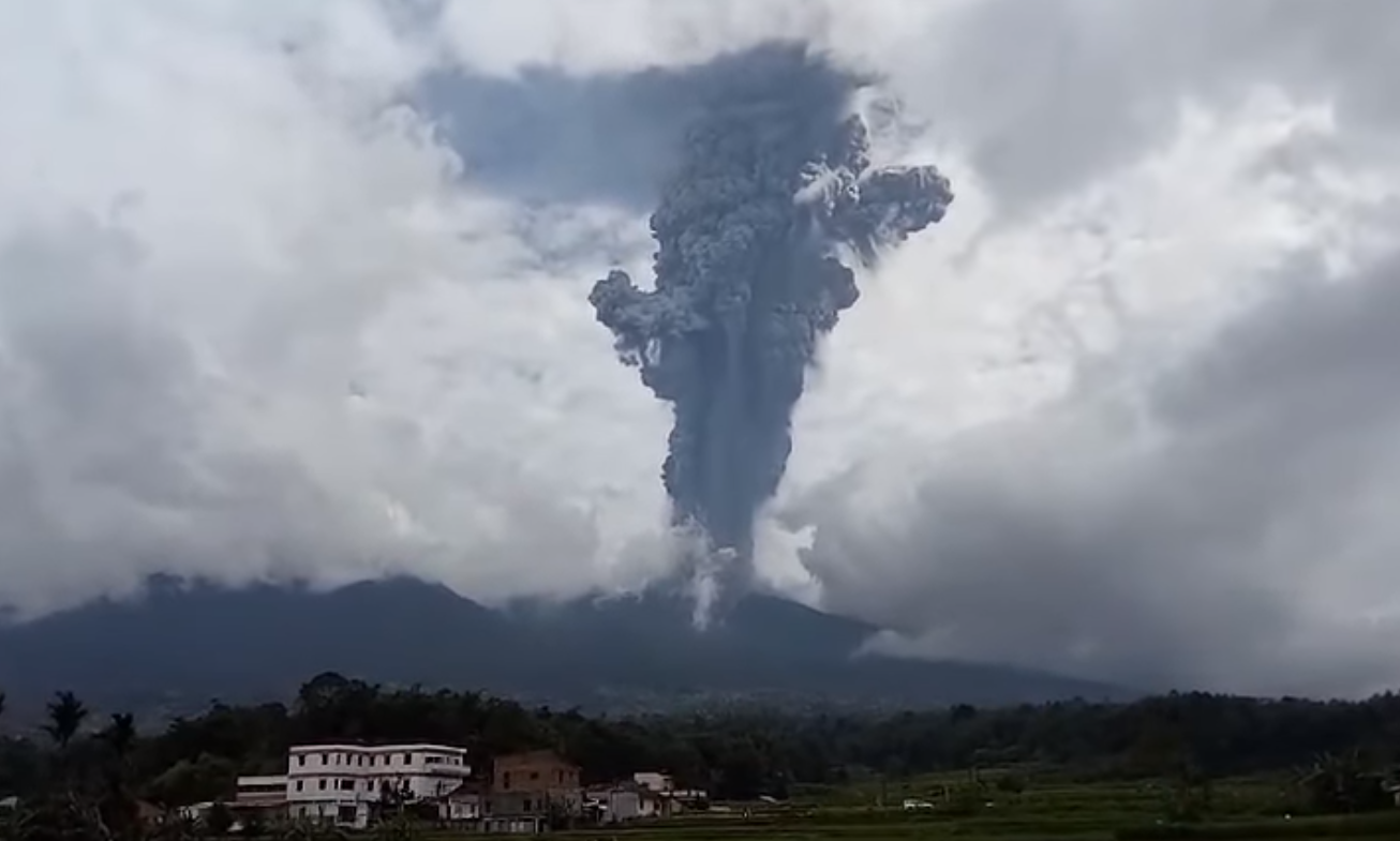
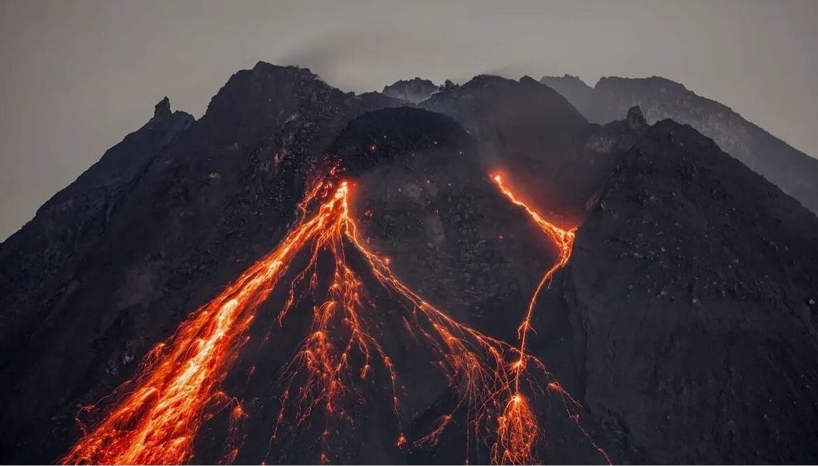
The PVMBG reported that eruptive activity at Marapi (in Sumatra) continued from December 27, 2023 to January 2, 2024, although fog and rain sometimes prevented visual observations of the summit. On December 27 at 12:05 p.m., a dense plume of gray ash rose 1.5 km above the summit and drifted southwest and west. The ash plumes rose 500 to 700 m above the summit and drifted towards the South, South-West and West between December 31, 2023 and January 1, 2024. The alert level remained to 2 (on a scale of 1 to 4) and the public was warned to stay 3 km from the summit crater.
Source : CBNC Indonésia. GVP.
Photo : Buya Khalifah
Hawaii , Kilauea :
Saturday, January 6, 2024, 9:11 AM HST (Saturday, January 6, 2024, 19:11 UTC)
19°25’16 » N 155°17’13 » W,
Summit Elevation 4091 ft (1247 m)
Current Volcano Alert Level: ADVISORY
Current Aviation Color Code: YELLOW
Activity Summary:
Kīlauea volcano is not erupting. Over the past day seismicity has been low in the summit region, upper East Rift Zone, and Southwest Rift Zone. Unrest may continue to wax and wane with fluctuating input of magma to the area, and eruptive activity could occur in the near future with little or no warning. No unusual activity has been noted along the middle and lower sections of Kīlauea’s East Rift Zone.

Summit Observations:
Over the past 24 hours, seismicity has remained low in Kīlauea’s summit region with approximately 11 small-magnitude earthquakes (less than M2) recorded beneath the caldera. The region south and southwest of the caldera remains quiet. Periods of increased shallow seismicity can be expected to continue during repressurization of the summit magma reservoir, which has been ongoing since the end of the September 2023 eruption. Seismicity has not reached the levels that immediately preceded recent summit eruptions at Kīlauea.
Kīlauea’s summit region remains at a high level of inflation; relative tilt is above the level reached prior to the most recent eruption in September 2023, and it is higher than at any time since the 2018 eruption. Over the past 24 hours, summit tilt was mostly inflationary, with a switch to deflation just before 6 a.m. HST this morning, likely as part of a DI (deflation-inflation) event.
Source et photo : HVO