October 22 , 2022.
Philippines , Taal :
TAAL VOLCANO ADVISORY ,21 October 2022
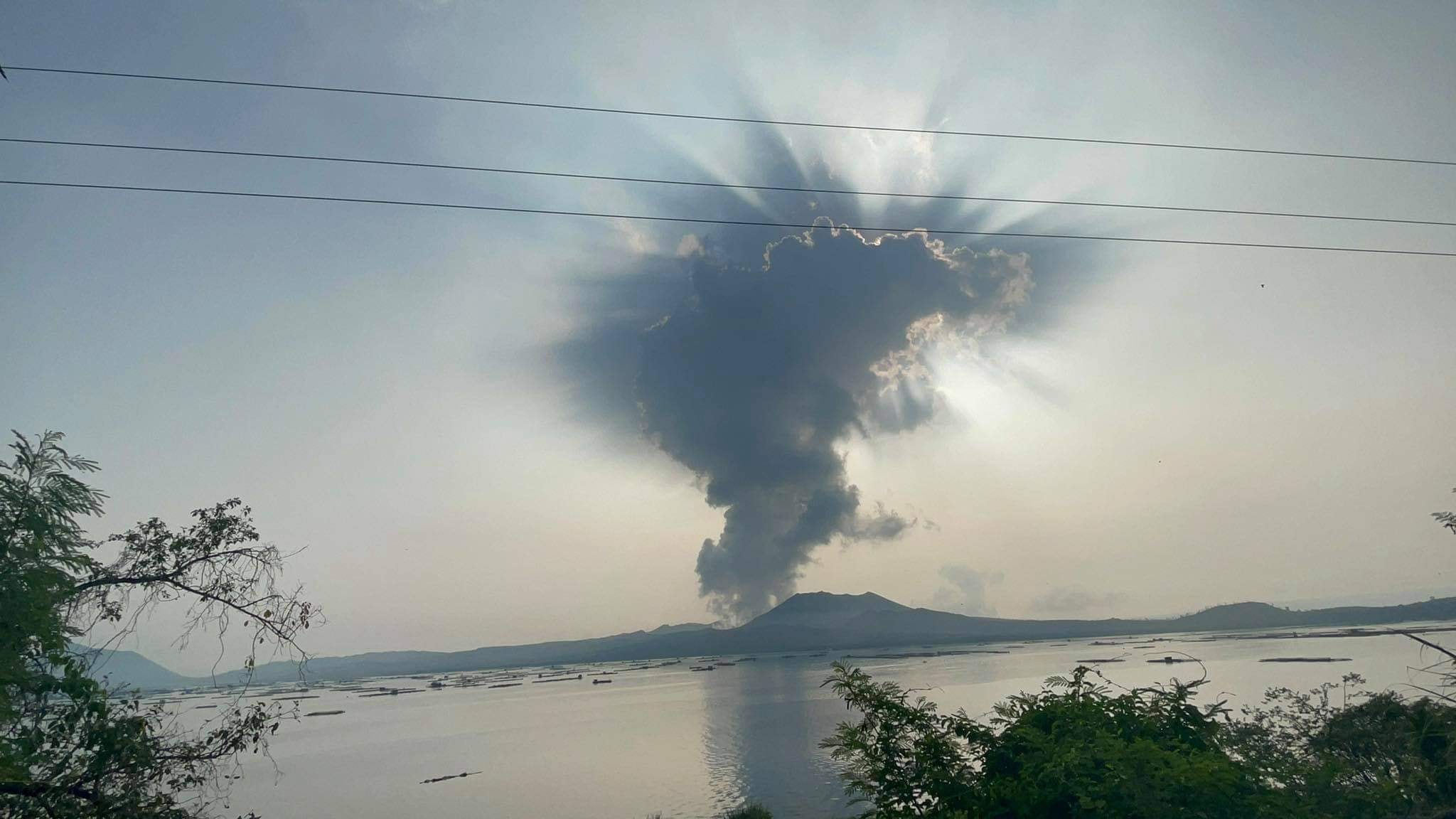
This is a notice of low-level phreatomagmatic activity in Taal Volcano.
A total of nineteen (19) very weak phreatomagmatic bursts have been detected by remote camera monitoring of the Taal Main Crater between 8:50 AM and 1:30 PM today, 21 October 2022, all emanating from a vent on its northeastern side. Some of these events produced 200-meter-tall steam-rich plumes with a few emanating from very short dark ash plumes that immediately collapsed into the Main Crater Lake (MCL). Many of the bursts were obscured by ongoing upwelling of hot volcanic gas in the MCL, while all events did not generate detectable signals in the seismic and infrasound records. Presently, Taal MCL has an acidity of pH 0.76 and temperatures reaching 65.1 ºC based on measurements on 12 October 2022. SO2 flux averaged 6,702 tonnes/day yesterday, 20 October 2022.
DOST-PHIVOLCS reminds the public that Alert Level 1 prevails over Taal Volcano, which means that it is still in abnormal condition and should not be interpreted to have ceased unrest nor ceased the threat of eruptive activity. Should current phreatomagmatic activity worsen or pronounced changes in monitored parameters forewarn of increasing unrest, the Alert Level may be raised to Alert Level 2. At Alert Level 1, sudden steam-driven or phreatic explosions, volcanic earthquakes, minor ashfall and lethal accumulations or expulsions of volcanic gas can occur and threaten areas within TVI. DOST-PHIVOLCS strongly recommends that entry into TVI, Taal’s Permanent Danger Zone or PDZ, especially the vicinities of the Main Crater and the Daang Kastila fissure, must remain strictly prohibited. Local government units are advised to continuously assess previously evacuated barangays around Taal Lake for damages and road accessibilities and to strengthen preparedness, contingency and communication measures in case of renewed unrest. People are also advised to observe precautions due to ground displacement across fissures, possible ashfall and minor earthquakes. Civil aviation authorities must advise pilots to avoid flying close to the volcano as airborne ash and ballistic fragments from sudden explosions and wind-remobilized ash may pose hazards to aircrafts.
DOST-PHIVOLCS is closely monitoring Taal Volcano’s activity and any new significant development will be immediately communicated to all stakeholders.
Source : Phivolcs
Photo : Seys Marasigan / Seys Channel.
Indonesia , Merapi :
Report on the activity of Mount Merapi from October 14, 2022 to October 20, 2022, Published on October 22, 2022
RESULTS OF OBSERVATIONS
Visual
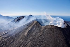
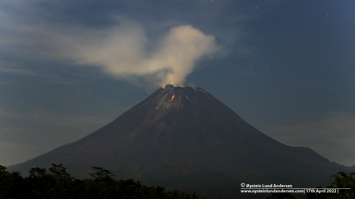
The weather around Mount Merapi is usually sunny in the morning and afternoon, while the evening is foggy. White, thin to medium thickness, low pressure, 600m high smoke was observed from Babadan’s Mount Merapi observation post on October 19, 2022 at 06:57 WIB.
This week, 5 lava avalanches were observed in the Southwest, descending the Bebeng River with a maximum sliding distance of 1800 m. The sound of avalanches was heard from Pos Babadan 10 times with medium intensity
On the southwest and central dome still growing, but no significant morphological changes are observed. Based on photo analysis, the volume of the dome is calculated at 1,626,000 m3, and for the central dome it is 2,772,000 m3.
Seismicity
This week, the seismicity of Mount Merapi showed:
286 Deep Volcanic Earthquakes (VTA),
102 multi-phase earthquakes (MP),
411 avalanche earthquakes (RF),
41 emission earthquakes (DG),
8 tectonic earthquakes (TT).
1 Tremor (TR)
2 Low frequency earthquake ( LF)
The intensity of this week’s seismicity is still quite high.
Deformation
The deformation of Mount Merapi that was monitored using EDM and GPS this week shows no significant changes.
Rain and lahars:
This week, there was rain at Kaliurang observation post with a rain intensity of 37 mm/h for 270 minutes on October 20, 2022. It is reported that there is an increase in flow in Gendol rivers , Woro and Boyong.
Conclusion
Based on the results of visual and instrumental observations, it is concluded that:
-The volcanic activity of Mount Merapi is still quite high in the form of effusive eruption activity. The state of the activity is defined at the « SIAGA » level.
-The current potential dangers are lava avalanches and hot clouds in the South-South-West sector including the Boyong River up to 5 km, the Bedog, Krasak, Bebeng Rivers up to 7 km. In the South-East sector, they cover the Woro River with a maximum of 3 km and the Gendol River for 5 km. While the ejection of volcanic materials during an explosive eruption can reach a radius of 3 km around the summit.
Source : BPPTKG.
Photo : Oystein Lund Andersen.
Chile , Laguna del Maule :
Special Report on Volcanic Activity (REAV), Maule Region, Laguna del Maule Volcanic Complex, October 21, 2022, 2:10 p.m. local time (mainland Chile)
The National Geology and Mining Service of Chile (Sernageomin) announces the following PRELIMINARY information, obtained through the monitoring equipment of the National Volcanic Monitoring Network (RNVV), processed and analyzed at the Volcanological Observatory of the Andes del Sud ( Ovdas):
On Friday, October 21 at 1:57 p.m. local time (4:57 p.m. UTC), monitoring stations set up near the Laguna del Maule volcanic complex recorded an earthquake associated with both rock fracturing and fluid dynamics inside the volcanic system (hybrid type).
The characteristics of the earthquake after its analysis are as follows:
ORIGINAL TIME: 1:57 p.m. local time (4:57 p.m. UTC)
LATITUDE: 36.17°S
LONGITUDE: 70.443° W
DEPTH: 0.2 km
LOCAL MAGNITUDE: 3.7 (ML)
REDUCED TRAVEL: 530 (cm*cm)
COMMENTS:
There is no recording of surface activity thanks to the IP camera installed in the area. After the reported event, no significant change in seismic activity is recorded.
The volcanic technical alert remains at the Green level.
Source : Sernageomin.
Photo : Segemar.
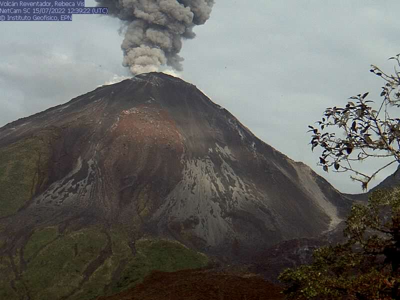
Ecuador , Reventador :
DAILY REPORT OF THE STATE OF THE REVENTADOR VOLCANO, Friday October 21, 2022.
Information Geophysical Institute – EPN.
Surface Activity Level: Moderate, Surface Trend: No change
Internal activity level: Moderate, Internal trend: No change.
Seismicity: From October 20, 2022, 11:00 a.m. to October 21, 2022, 11:00 a.m.:
There are no seismicity data.
Explosion (EXP): 9
Long Periods (LP): 2
Emission Tremors (TREMI): 12
Harmonic tremor (TRARM): 2
Rains / Lahars:
No rain was recorded in the area.
Emission / ash column:
There were 3 reports of ash emission by the Washington VAAC, with heights of 1,338 meters above crater level in a westerly direction.
Other Monitoring Parameters:
The WORLDVIEW system records 13 thermal alerts over the past 12 hours.
Gas:
The Mounts satellite system reported 82.8 tonnes of sulfur dioxide (SO2) for yesterday at 1:59 p.m. TL.
Observation:
During yesterday night an incandescence was observed at the level of the crater. At the moment, the volcano is cloudy.
Alert level: Orange.
Source : IGEPN.
Photo : IGEPN ( archive).
Alaska , Great Sitkin :
52°4’35 » N 176°6’39 » W,
Summit Elevation 5709 ft (1740 m)
Current Volcano Alert Level: WATCH
Current Aviation Color Code: ORANGE
Slow eruption of lava from the summit crater of Great Sitkin Volcano continued this week. Cloudy conditions obscured most satellite and webcam images through the week, but a few clear satellite images indicated elevated surface temperatures overnight on October 17 and continued slow growth of the lava flow field to the south and east. Low-level seismic activity consistent with slow, continued lava eruption was observed over the past week.
The terrain is steep near the terminus of the lava flow lobes, and blocks of lava could detach without warning and form small rock avalanches in these valleys. These avalanches may liberate ash and gas and could travel several hundred meters beyond the lava flows; they would be hazardous to anyone in those areas.
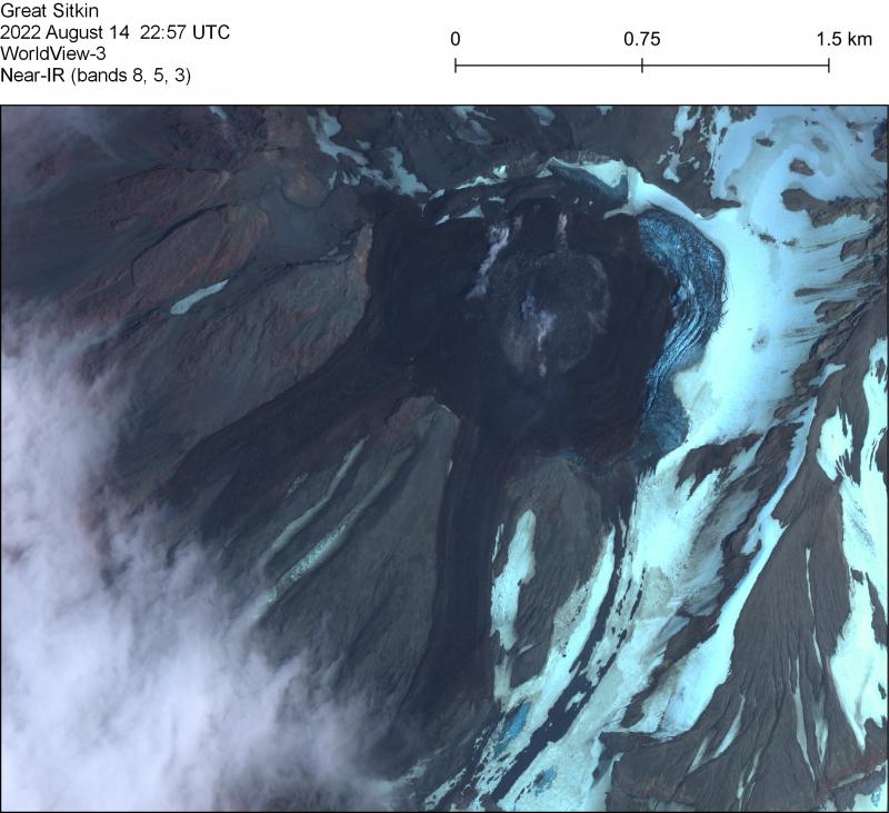
WorldView-3 satellite near-infrared image of the lava flow field at Great Sitkin on August 14. Current dome growth is focued in the gray region in the center of the summit dome.
Great Sitkin is monitored by local seismic and infrasound sensors, satellite data, web cameras, and regional infrasound and lightning networks.
Great Sitkin Volcano is a basaltic andesite volcano that occupies most of the northern half of Great Sitkin Island, a member of the Andreanof Islands group in the central Aleutian Islands. It is located 26 mi (43 km) east of the community of Adak. The volcano is a composite structure consisting of an older dissected volcano and a younger parasitic cone with a 1.5 km-diameter summit crater. A steep-sided lava dome, emplaced during the most recent significant eruption in 1974, occupies the center of the crater. That eruption produced at least one ash cloud that likely exceeded an altitude of 25,000 ft (7.6 km) above sea level. A poorly documented eruption occurred in 1945, also producing a lava dome that was partially destroyed in the 1974 eruption. Within the past 280 years a large explosive eruption produced pyroclastic flows that partially filled the Glacier Creek valley on the southwest flank.
Source : AVO.
Photo : Loewen, Matt